Although we are branded as an Atlantic hurricane site, we here at The Eyewall feel Hurricane Hilary deserves special attention, given that it could produce some very significant impacts to parts of the Southwest U.S., where many of our readers have friends or family. Thus, we will be covering Hilary extensively into next week. Feel free to spread the word.
One-sentence summary
Major Hurricane Hilary is rapidly intensifying off the coast of Mexico, and although it will weaken as it comes north, it is setting up to bring a potentially extreme rain and flooding event to parts of the deserts and/or mountains in California and Nevada.
Happening now
Hurricane Hilary has exploded since yesterday, now classified as a major, category 3 storm, with maximum sustained winds of 120 mph.
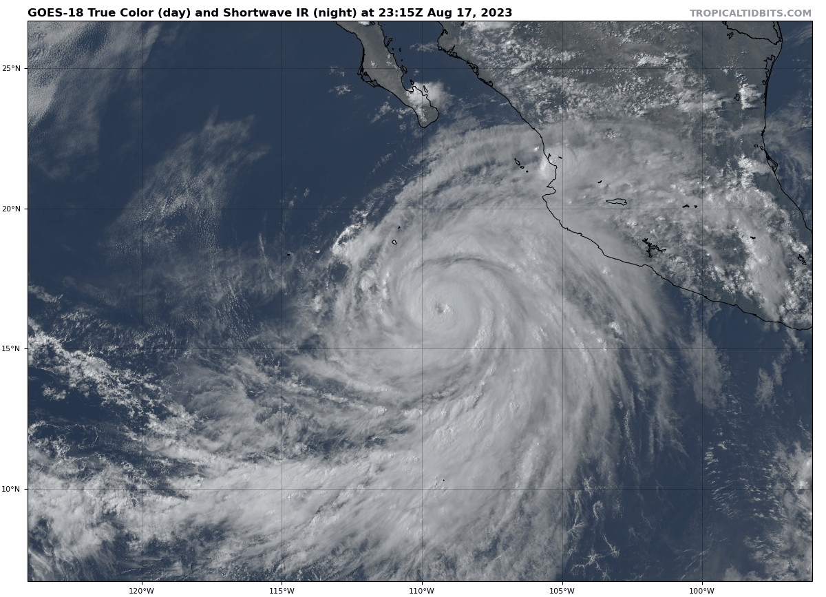
Additional strengthening is likely, and Hilary is expected to become a category 4 storm by tomorrow. Hilary has been able to tap into an exceptionally favorable environment for rapid intensification, and that will allow the storm to peak at a high end. Warm water and low shear will do that.
Hilary’s trek toward Baja
Tropical storm watches and warnings are posted for Baja, including Cabo with tropical storm conditions beginning at Cabo tomorrow night. If you know anyone visiting Cabo (or any southern Baja locations), my guess is that they are well prepared to handle a tropical storm type impact. Models are in high confidence that Hilary will pass safely offshore to keep impacts moderate there. The main threat may be heavy rain that causes flash flooding, as well as very rough surf at the coast.
Hilary will begin to weaken as it encounters cooler waters off Baja, and it is expected to make landfall in the north or just scrape the northern coast of Baja before coming ashore in California. Hurricane force winds are possible in northern Baja but they may come up just short.
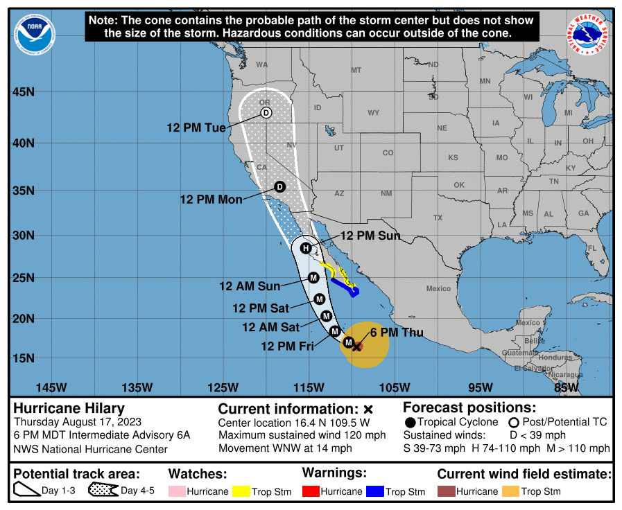
That being said, interests along the Baja Peninsula should continue to monitor Hilary’s progress as it comes north.
The main event: Rain and flooding in the desert
For those of you living in the Desert Southwest, particularly interior California, you hear “hurricane” and you may think wind. Yes, winds may be part of the issue, particularly along eastern facing slopes of the mountains in SoCal. But take it from someone who lives in Houston and helped get people through Hurricane Harvey: Heed the warnings about rainfall.
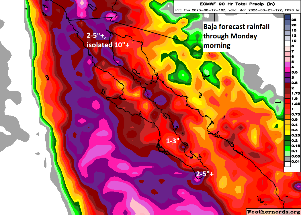
The current rainfall forecast for the Southwest shows anywhere from 2 to 6″ over a broad area, with locally higher amounts, perhaps up to 10″ or even more in parts of California and Nevada.
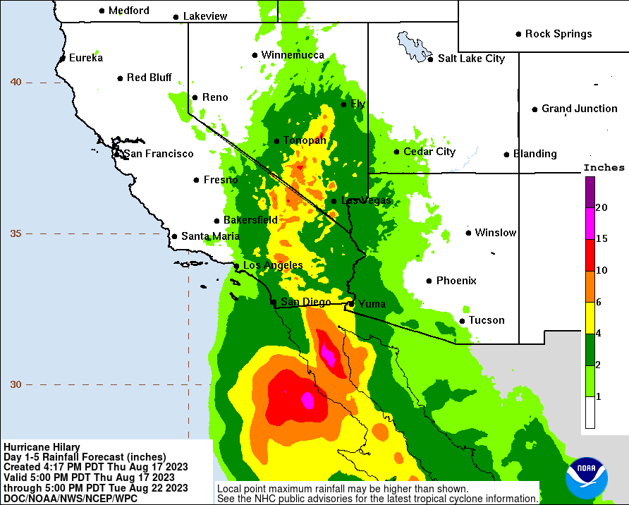
How much rain is this? Death Valley averages a bit over 2″ of rain a year, and they’re currently forecast to receive anywhere from 2 to 5 inches with Hilary. You can do the math. Rain like this comes down harder than usual and can quickly lead to flash flooding, arroyo flooding, and potentially longer-term issues in some spots from too much rain.
Put simply: This has the potential, if not the likelihood of being one of the most significant rain events in recent years in the deserts of southeast California and southern Nevada. For folks in Phoenix, this probably is not your storm. But for folks in Vegas and over the passes from LA and San Diego, this has potential to cause significant and severe disruption Sunday and Monday into early next week.
In addition to the rain, there will be significant marine issues along the coast from swells and rough seas. Tropical storm force winds are possible down to lower elevations in spots and along the coast, and stronger winds are likely in the mountains. We’ll get a better read on specifics of that once Hilary’s final track comes into view.
Anyone with interests in SoCal, Nevada, along the Colorado River in western Arizona and even north into parts of Idaho and Montana will want to be ready for Hilary’s arrival and plan to deal with some disruptions, if not significant ones Sunday and Monday. Folks just west of these locations, into the Central Valley and Central Coast of California and the Sierra will want to monitor forecast progress as well. A shift west could change impacts from Tahoe down through Santa Barbara.
All in all, this is looking like a high impact storm. We’ll keep you posted.
Thank you so much for your updates, Atlantic and Pacific. All always appreciated. Read them everyday.
Thanks for the update. Any impacts to Reno, in your estimation? I grew up there, and still have friends living in the area.
NWS Vegas showed probability cone of Reno having the storm center overhead by Monday.
There is certainly a chance for some rain in and around Reno. The heaviest rain probably misses them to the south, but if it holds together better or comes in at a different angle or something, that could shift that around some. I don’t think the impacts there will be as significant as in southern Nevada, but a good idea to pay attention.
Thanks! I will be paying close attention.
Slippery slope, fellas. I have a distant relative in Hawaii and am concerned about wildfires.
I do not remember ever hearing Hurricane and Southern California mentioned together…
Thank you for covering Hilary, guys! We have Houston ex-pat family and friends in both SoCal and Las Vegas who will appreciate your help. Thanks again!
Thank you for covering Hurricane Hillary. Our daughter lives in LA, and a hurricane is the last thing they expect. I appreciate the way Space City Weather and The Eyewall explains weather events and provides the facts. Thank you.
I sent your latest to my cousin in San Diego. Her response: “Thanks – I signed up for the Eyewall newsletter and checked out the website – great information, the best I’ve seen here. Have shared with my neighbors and friends out in the desert.”
Thanks for your good work!
I sent your latest to my cousin in San Diego. Her response: “Thanks – I signed up for the Eyewall newsletter and checked out the website – great information, the best I’ve seen here. Have shared with my neighbors and friends out in the desert.”