One-sentence summary
A tropical wave in the Gulf offers a slight development chance and some beneficial rains for south Texas, and of the three tropical storms in the Atlantic this morning, only Franklin needs watching for land impacts in Hispaniola.
Tying a bow around Hilary
We hope that all our new readers in California and the Southwest are doing ok this morning after Hilary’s rains yesterday. It sounds as if the mountains and some parts of the desert were particularly hard hit overnight with numerous debris flows, mudslides, and road washouts reported. A better assessment of the damage should emerge today.
While we are a tropics-focused site, we hope you’ll find our information interesting to share with your friends and family. And we may cover more than just hurricanes here eventually, in which case California would be a focus of ours. We are happy to have you here.
Gulf system & Texas rain
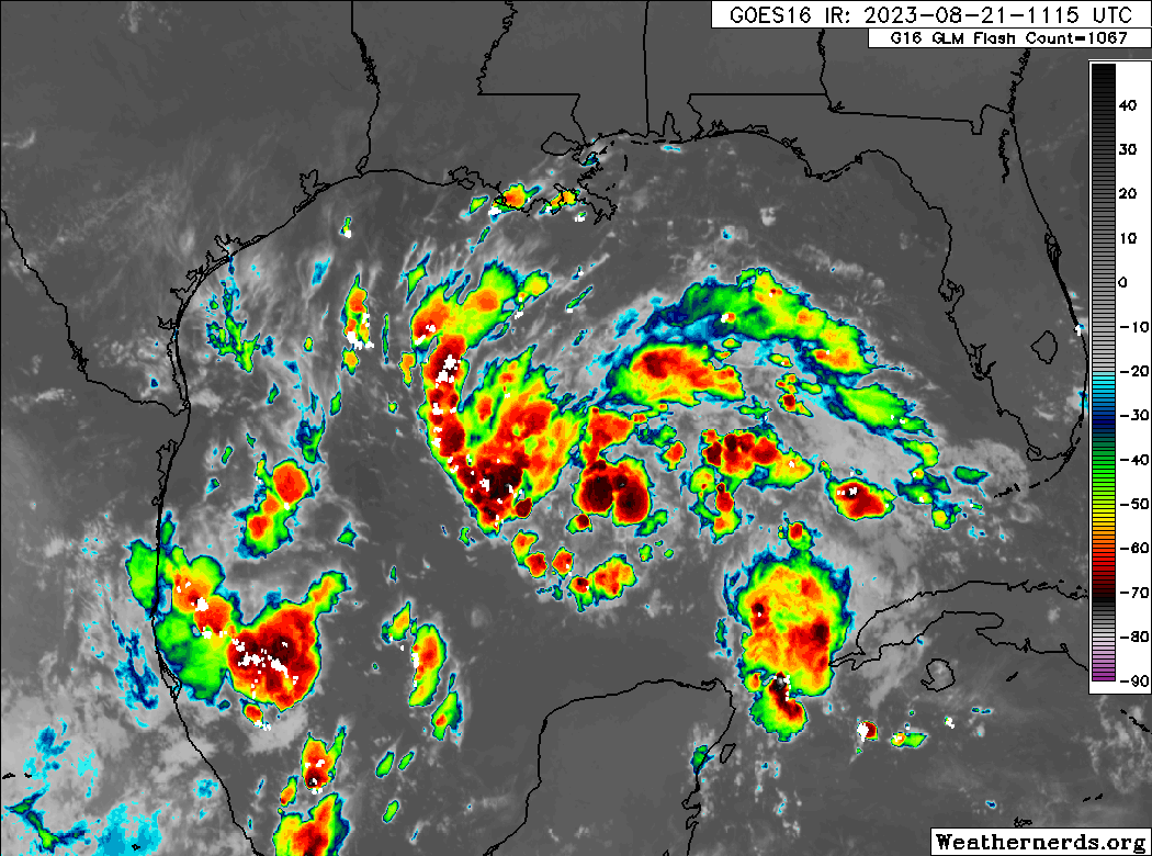
First up today, let’s talk about the Gulf of Mexico. We have seen no real progress toward better organization overnight from the tropical wave, Invest 91L in the eastern Gulf.
Just as a quick reminder: Invests are really just meteorological classifications given to tropical disturbances so extra data can be compiled about them; literally “an area of investigation.” There’s no strict definition, but they go from 90 to 99 and then recycle again. In the Atlantic we use “L” as an identifying abbreviation. The East Pacific is “E,” West Pacific “W,” etc.
Anyway, 91L has a broad circulation this morning but does not appear to be tightening up any as of yet. The good news is that this system has about 24 hours left over water before it comes ashore in South Texas. The most likely outcome at this point is an approach just south of Corpus Christi or north of Brownsville.
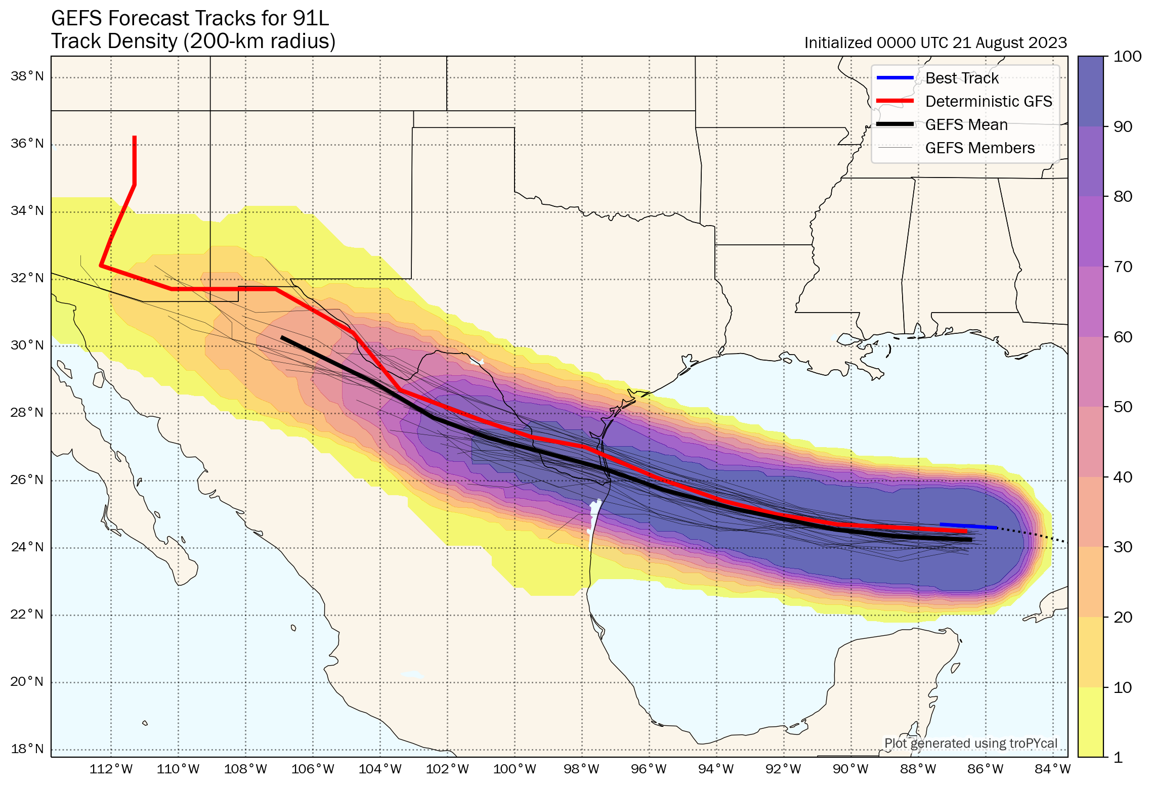
Given that we have 24 hours left and given how this thing looks on satellite, my hunch is that if we see this upgraded we may skip the formalities and go right to a tropical storm. The next name on the list would be Harold. At worst, this would probably become a low-end tropical storm (45 to 55 mph maximum sustained winds, mostly in heavier rain bands and over water).
More importantly, this will be a rainmaker for Texas. The entire state desperately needs rain.
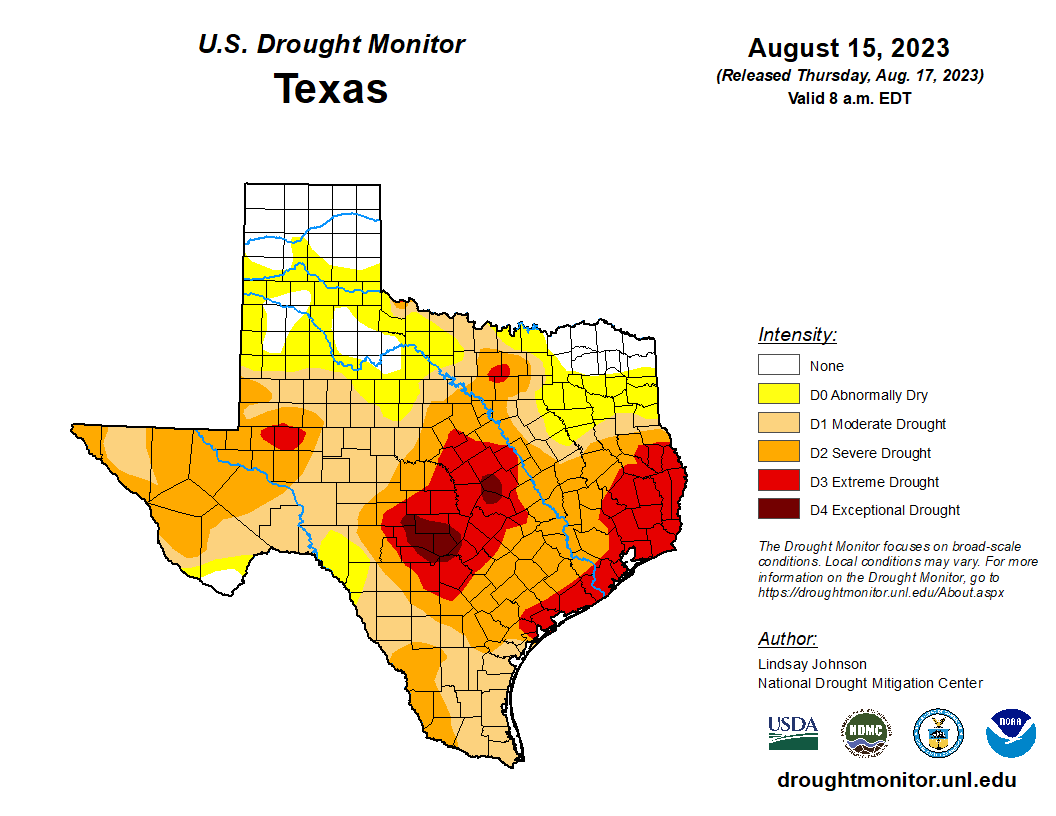
East Texas and the upper Texas coast are in extreme drought, with pockets of exceptional drought in Hill Country northwest of San Antonio. A quick moving tropical system would be virtually 100 percent positive in Texas right now. This will help. Rain totals of 1 to 3 inches with higher amounts are expected for South Texas, mainly south of Corpus Christi into the Rio Grande Valley and west toward Laredo. Northern Mexico will also receive healthy rains from this.
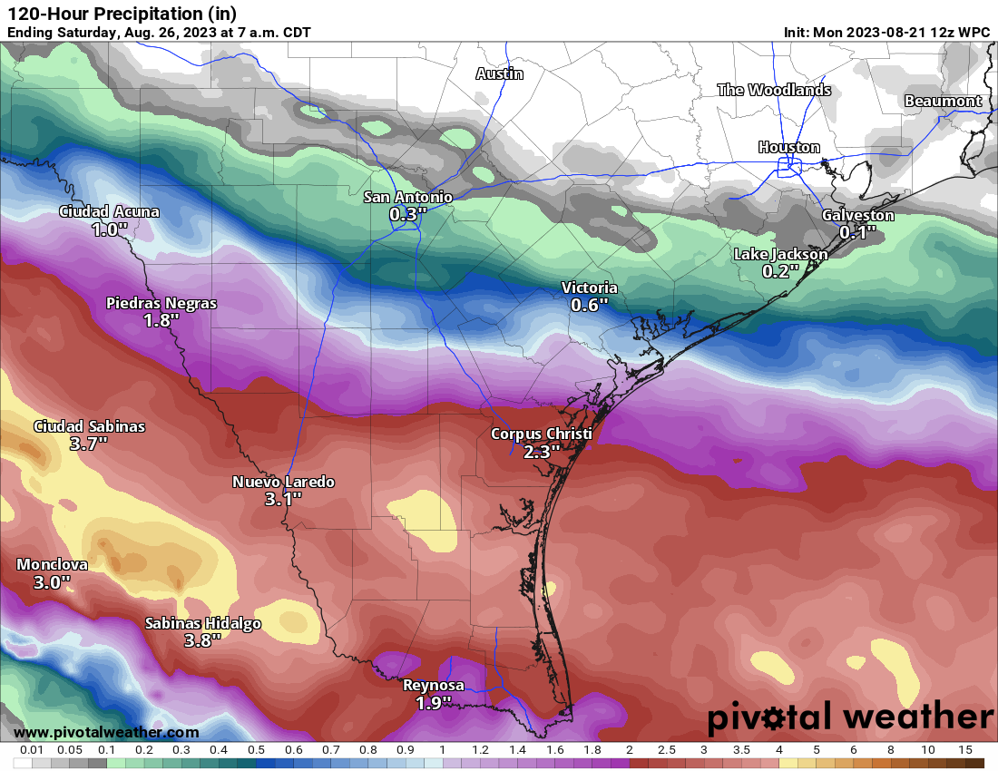
While this will not end drought for South Texas, it will greatly help. Unfortunately, the hardest hit parts of the state are expecting little to no rain this week, meaning drought and fire danger will worsen. See our companion site, Space City Weather for more on that.
Franklin to turn toward Hispaniola
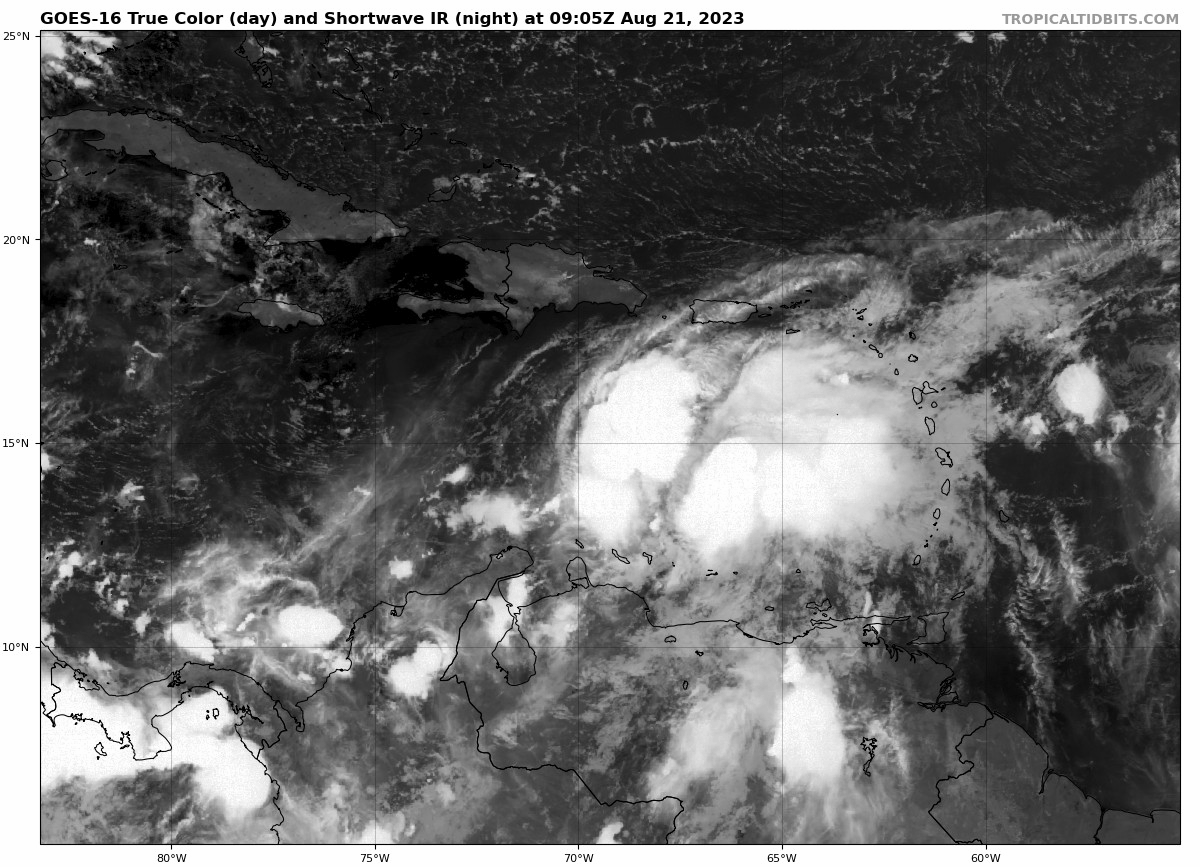
Yesterday afternoon, Invest 90L in the Gulf was upgraded to Tropical Storm Franklin. Franklin is impressive looking this morning, less so for organization and more for how much moisture it is carrying.
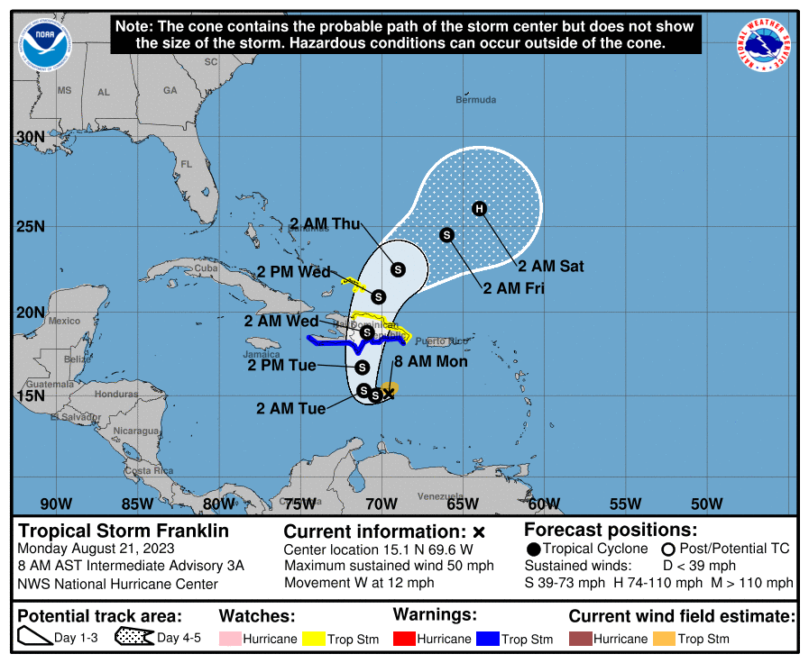
Franklin is expected to turn to the north, almost like something you’d see in autumn. Why? An upper level low and a fairly deep trough for August over the western Atlantic will act to scoop it up, as high pressure over the southern Plains effectively acts as a “block” to letting this come west.
So Franklin will make a hard right toward Hispaniola tonight or tomorrow. Exactly where this turn happens will determine where on Hispaniola Franklin comes ashore. This will have implications on specific rain totals for both Haiti and the Dominican Republic. As of now, the heaviest rains from Franklin are poised to hit on the Dominican Republic side of Hispaniola, where upwards of 8 to 12 inches or more will be possible, especially in the eastern part of the country.
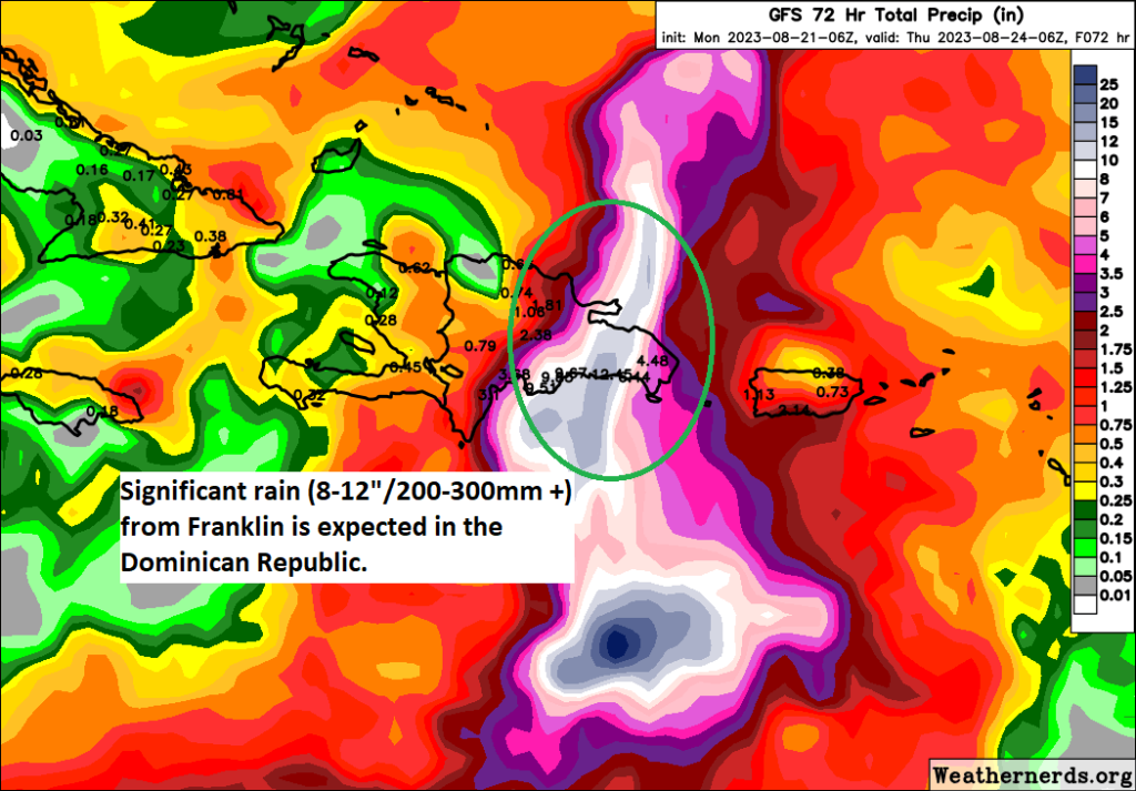
Flooding is possible there, and some of it could be relatively significant, in addition to tropical storm conditions. For Puerto Rico, you’ll be on the eastern flank of Franklin’s circulation, which should allow for occasional bands of rain to push north into the island, and this too could lead to some more localized heavy rain or flash flooding issues with totals of 3 to 6 inches possible in the worst cases.
Franklin will likely hit Hispaniola as a moderate to strong tropical storm. The island will weaken it somewhat as it emerges to the north, but then it may find a more hospitable environment out ahead of it to gain strength. There is a good chance we could have Hurricane Franklin by the end of the week over the open Atlantic. Initially, Franklin will turn north or northeast. Except there’s a bit of a problem. Models indicate a ridge in the eastern Atlantic may try to build west enough to bump Franklin back off to the northwest, which means there is at least some chance Bermuda will be in play for this as it goes north. Eventually Franklin will turn back out to sea, but where that happens relative to Bermuda is impossible to say right now. So interests in Bermuda will want to follow Franklin’s progress closely in the coming days.
Additionally, if Franklin can get its act together in the Atlantic, there may be some rough surf and rip tide conditions possible on the U.S. East Coast next weekend.
The rest of the Atlantic
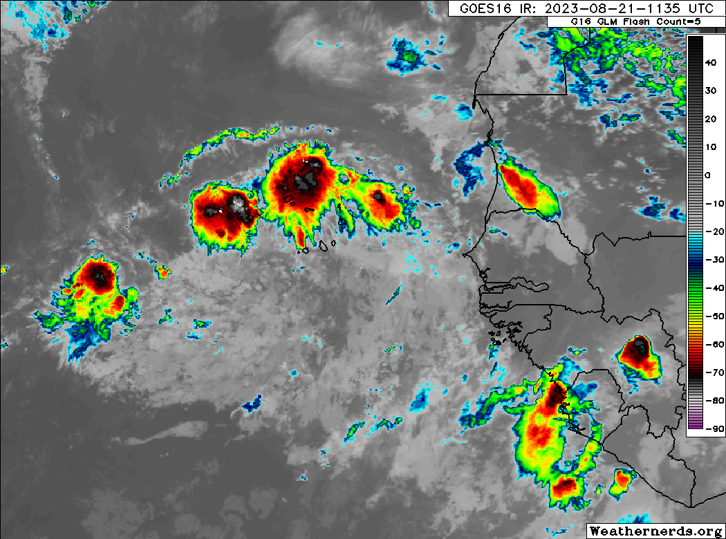
Tropical Depression 6? Now Tropical Storm Gert and soon to be history. Tropical Storm Emily formed yesterday from Invest 98L, and that should dissipate today. It is no threat to land. Behind Emily, we have Invest 92L, which has a solid chance at becoming a named storm in the next few days.
It will likely also turn out to sea.
What’s next?
Looking out in time, once we unclog the Atlantic of the current logjam of systems, we can focus our attention more on two areas. One will be the potential that a system can spin off a potential “gyre” circulation over Central America, but that is looking a bit less impressive today than it did last week. The other area will be off Africa, where additional waves may emerge and threaten development in the next couple weeks. In truth, nothing looks especially concerning right now as we head into the start of September. Obviously, we’ll keep you posted.
Additionally, if Franklin can get its act together in the Atlantic, there may be some rough surf and rip tide conditions possible on the U.S. East Coast next weekend.
Another great job. Thanks for your efforts in educating/informing the public.
A minor nit from the quote above…. the correct term is rip current. See the NWS glossary or AMS Dictionary for complete definition.
All the best.
Why do the meteorologists name a disturbance so quickly. A TS gets a name once sustained winds are at 39 miles an hour for one minute. Seems it should be longer, at least 5 minutes if not 30 minutes. To me it seems they do it, so to legitimize their predictions.
There’s no agenda. The data is the data, and when it says it’s that, they go with it. Is it perfect? No, not at all, and sometimes there is periodically too much “rigor” put into determining if it is what it is IMO, but the process works for the most part.
I actually like seeing what’s going on on the west coast too, especially since we are entering an era of chart toppers and firsts. I love what you guys do, and you are the first thing I open in the morning since our weather is so mercurial.
Thank you! We may expand this to go beyond tropics, as noted. We know people love their weather. I will say that if the response to Hilary is any indication, we will find an audience for other stuff.
great coverage ☺️
looks like beautiful CC will get some relief 🌬 🌧
always grateful ⚘
Thank you!
I’d like to thank you so much for presenting facts and not screaming hype! For months the “experts” have been raving about the boiling Atlantic and the equally hot GOM and how this is going to override the developing el nino. If memory serves, we’ve had exactly ONE hurricane. Don was a hurricane for less than a day out in the middle of the Atlantic.
Today, we are being told elsewhere that we’re having a “historic outbreak” in the Atlantic. A few of the puniest cyclones ever seen qualify for names and aren’t even expected to last through the day. Not questioning the NHC – the storms meet the parameters, but anyone who could make a “historic outbreak” out of this obviously has an agenda that doesn’t interest me.
This is getting too long for a “comment”, so I’ll just say THANKS again.
Thanks for the kind words! There are notable aspects of what’s happening, and I think that forecasts for this season were mostly prudent, but we try to present it all in a manner that’s pretty straightforward and not over the top. Glad it’s resonating!
Why did Franklin get named after Hilary? F comes before H and I thought they went down the alphabet.
They do go alphabetically, but there are different lists depending on where they form – Atlantic vs Eastern Pacific vs Central Pacific. Based on the number of storms so far this year, the Pacific reached letter H before the Atlantic. The full list for 2023 is here: https://www.nhc.noaa.gov/aboutnames.shtml
The Atlantic name list is separate from the Eastern Pacific name list.
I swear by your local weather and hurricane forecasting, and, as you mentioned today, would love for you to branch out into other types of disasters!
Thank you, Judy!