One-sentence summary
Tropical Depression 9 will move into South Texas, where tropical storm warnings are now posted, with gusty winds and heavy rain tomorrow.
TD, TD Number Nine
The National Hurricane Center upgraded Invest 91L in the Gulf to Potential Tropical Cyclone 9 this morning and since its potential has been realized, it is now Tropical Depression 9. Despite these changes, they were mostly expected, and not much has changed from our morning post in terms of expected impacts in Texas and Mexico.
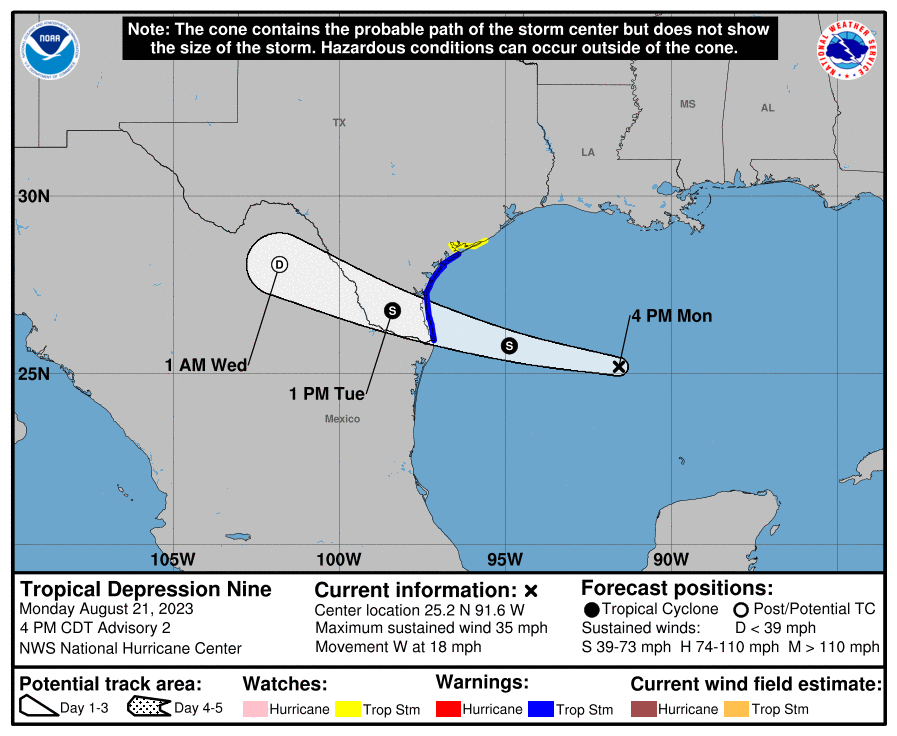
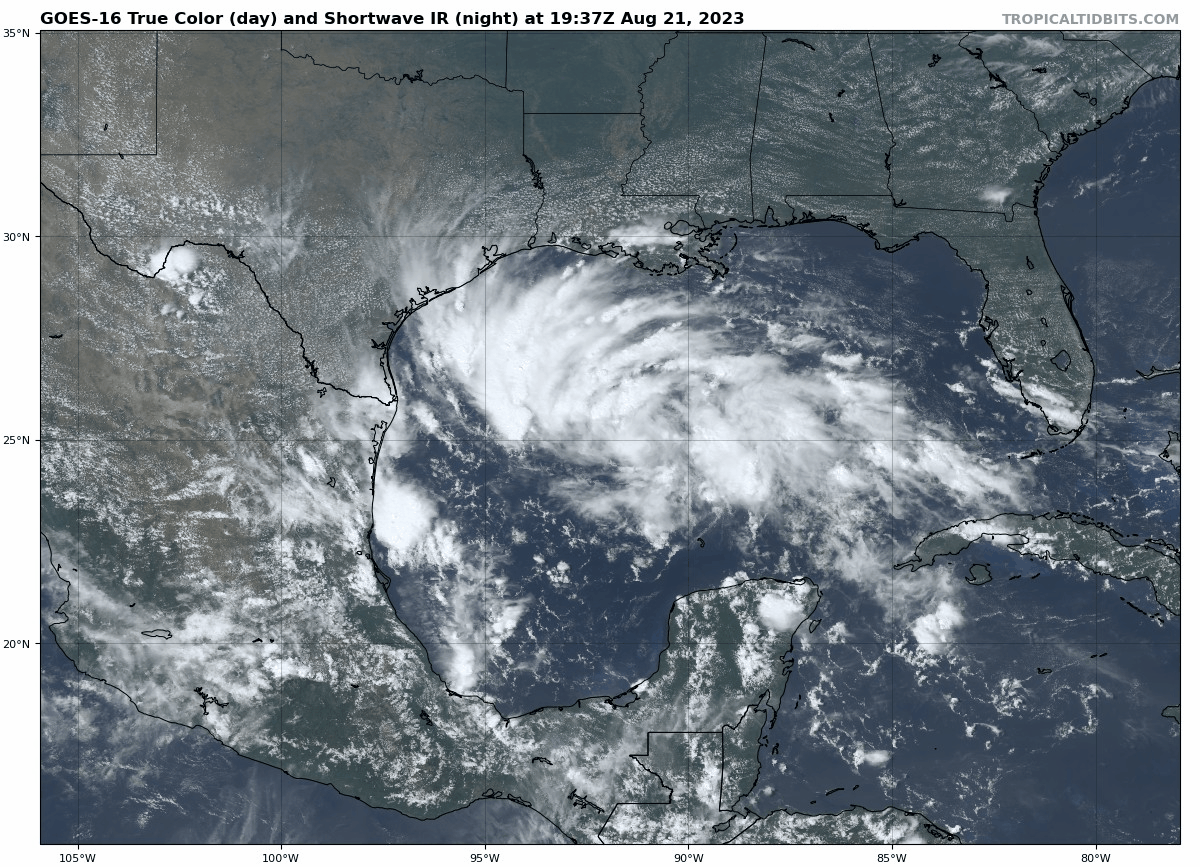
Tropical Storm Warnings are posted along the Texas coast from the Rio Grande River north past Corpus Christi to Port O’Connor. A Tropical Storm Watch extends north from there to Sargent, TX. Looking at TD 9 on satellite this afternoon shows a whole lot of storms. I said it this morning, and I’ll say it again. We are fortunate that this thing has a limited amount of time left over water.
It has all the ingredients you need in place to blow up into a big storm, except the most critical thing: Time. The depression is racing west at 18 miles per hour, which means it will be ashore in Texas by Tuesday morning. Impacts will be minor to moderate in South Texas, with the potential for some gusty winds to tropical storm force, mainly south of Corpus Christi and offshore. Meanwhile, beneficial rain will fall in South Texas, where generally 1 to 3 inches will fall. There will likely be a few pockets of 4 to 5 inches in Brush Country and more into the mountains of Mexico.
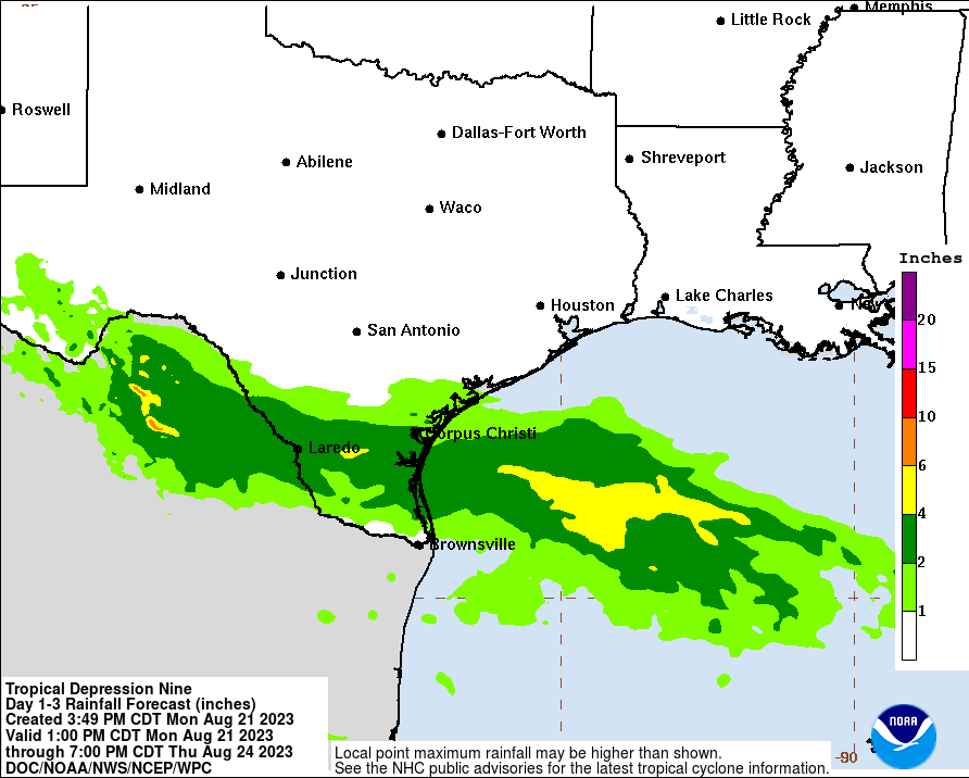
Rainfall impacts will be minimal north of there, with Houston and San Antonio mostly missing out on anything. In fact, with a bit of a breeze in between the heat ridge to our north and TD 9 to our south, we may have a slightly enhanced risk of fire danger in parts of Texas again on Tuesday. When it fails, it fails hard.
In addition to heavy rain in South Texas, there is also a chance for isolated tornadoes, as is often the case with landfalling tropical systems. But the main issue to impact your daily life in that area will be heavy rain.
By Wednesday, TD 9 or Harold will make its way across Mexico, and a piece of its remnants may actually find its way into the monsoon flow in New Mexico and Arizona, which would bring some beneficial rain to those areas that mostly missed out on Hilary’s rainfall this past weekend. Rare is the tropical system that is mostly a net positive, but PTC 9 may very well be just that. We’ll keep an eye on rain totals tomorrow to make sure things stay under control.
Elsewhere: Franklin looks to be a big rainmaker in Hispaniola
Franklin’s forecast is mostly unchanged over the next couple days, except for rainfall. There was a bit of a healthy shift west in the highest forecast totals over the next 3 days, which brings the heaviest rainfall a little farther west in Hispaniola, closer to the Dominican Republic border with Haiti.
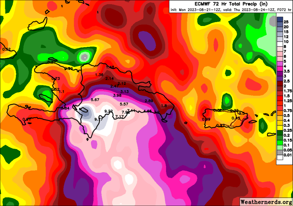
Flooding is likely in the southern portion of Hispaniola. Obviously this area is occasionally susceptible to bad bouts of flooding, so hopefully preparations are being made to manage this as best as possible.
Franklin is still expected to come ashore as a tropical storm, though I suppose the odds of a low-end hurricane are not zero. Regardless, the impacts will be similar. As much as 10 to 15 inches of rain may fall on parts of Hispaniola, particularly in the southern Dominican Republic. There’s a good deal of uncertainty on what happens beyond Hispaniola as it lifts north into the Atlantic, something we’ll try to hone in more on in the coming days.
We’ll have more on both of these systems in the morning.
With Hilary about to land on the West Coast, I reached out to a brother-in-law in Ridgecrest, CA. Your forecast anticipated 40 mph gusts and 4.4″ rain. He texted me back to report winds and 5.19″ of rain. I was glad you gave him a “spot on” heads up in advance. Great job!
Glad it worked out!