One-sentence summary
Tropical Storm Harold will make landfall soon near South Padre Island, TX bringing rain and storms to Texas and Mexico, while Tropical Storm Franklin is struggling in the Caribbean but still aiming to bring heavy rain to Hispaniola.
Tropical Storm Harold
Tropical Depression 9 was upgraded to Tropical Storm Harold overnight. In a twist of minor irony, Harold will make landfall about 100 miles south of the storm whose name it replaced (Harvey) on the Texas coast in about 4 to 6 hours.
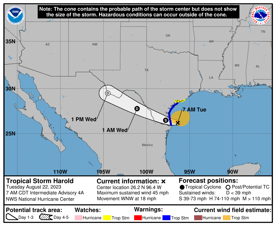
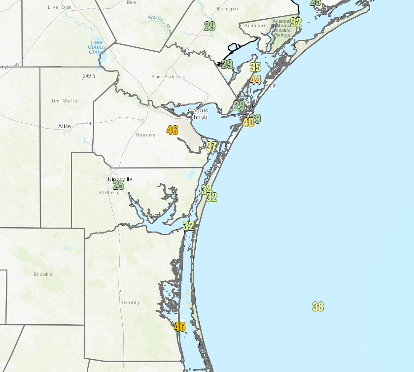
Harold is struggling a bit this morning in terms of organization. It has 45 mph maximum sustained winds, but it is clearly dealing with a hostile environment for quick organization. There have been wind gusts as high as 46 mph in Corpus Christi and south of there, mostly in heavier showers.
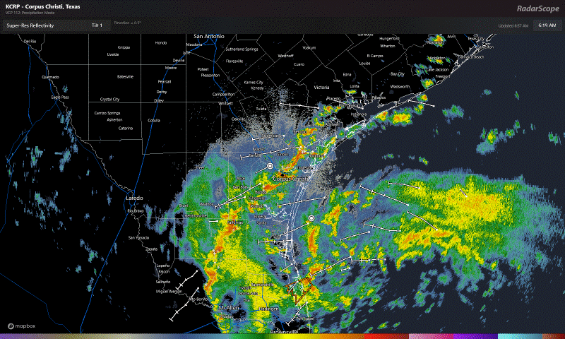
Showers and storms are pushing across South Texas this morning and into Mexico. Steadier rain is waiting offshore and looks as if it will push into Corpus Christi and points south for the later morning. The Valley may see more intermittent rain and thunderstorms.
Within these thunderstorms, as occasionally occurs with tropical storms, isolated tornadoes are possible. Even some of the more intermittent and isolated showers well north of the center (toward El Campo or Victoria or just south of San Antonio) could produce an isolated, brief spin up. Something to be aware of in South Texas today.
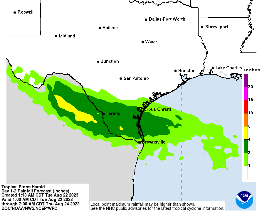
Total rainfall will be on the order of 1 to 4 inches in South Texas, with the highest amounts just west of the Lower RGV back toward Laredo and into Mexico, where totals in isolated spots will approach 6 to 10 inches. Some of the rain may be heavy enough to produce isolated landslides in the mountains of Mexico, and flash flooding is possible in northern Coahuila and northern Nuevo Leon.
Harold will quickly move inland today and tomorrow, and it should be into the Desert Southwest, aiding in some rainfall by tomorrow evening.
Tropical Storm Franklin
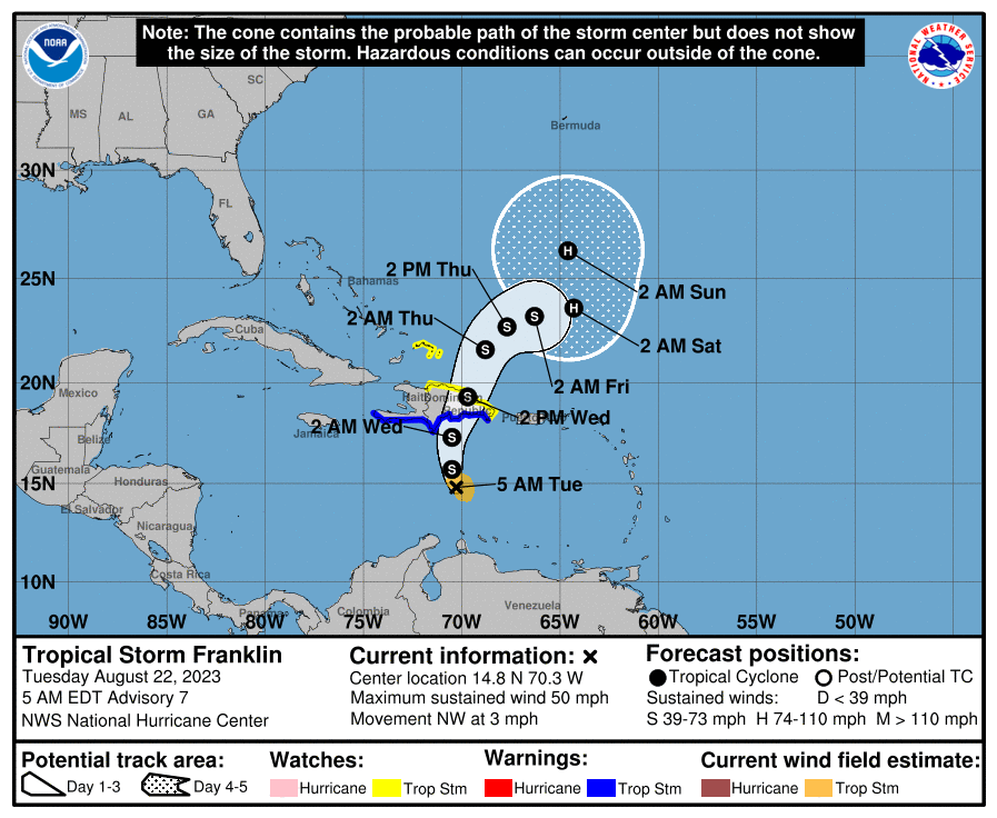
We’re all having a bit of a difficult time finding the exact location of Franklin’s center this morning, as it is presumed to be drifting northwest in the Caribbean.
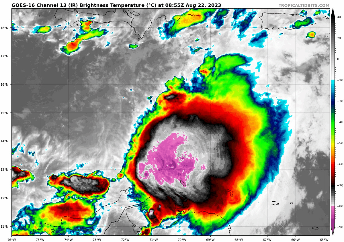
If you look at the satellite image above, you can just see South America’s coast at the bottom and Puerto Rico at the top right. Hispaniola is in the middle near the top. The bright colors indicate deep, intense thunderstorm activity. If you look closely, you’ll notice that the main area of storms is actually being pushed south. There are also a bunch of lighter looking clouds moving left to right toward those storms. That indicates a whole lot of wind shear in the atmosphere. Tropical storms do not like wind shear, as it inhibits their development. Overall, Franklin is a moisture-laden but extremely disorganized tropical storm. It’s not clear that Franklin will get much better organized over the next couple days as it moves north toward Hispaniola.
Overall, Franklin’s main concern for people will be heavy rainfall, capable of producing flooding over Hispaniola, particularly in the Dominican Republic. The models differ on exactly where the heaviest rain will be, but they all put it in the southern Dominican Republic. The greatest uncertainty may be in southeast Haiti, where models have waffled a bit between manageable rainfall and some higher totals closer to 10 inches.
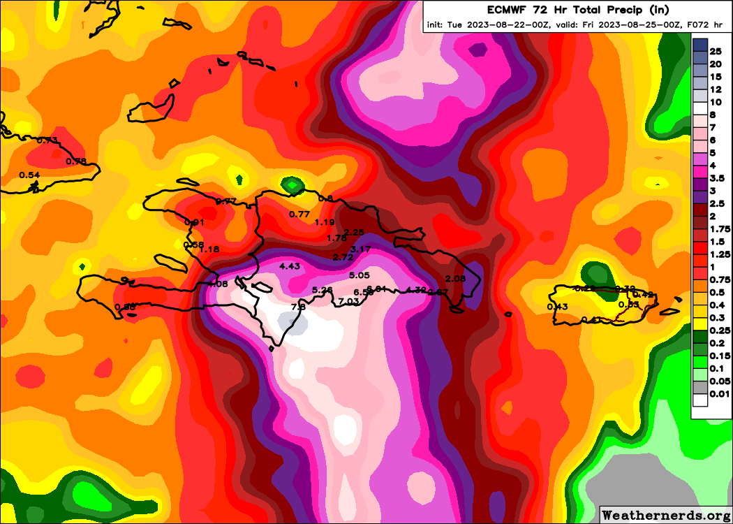
Flash flooding and mudslides are possible across the Dominican Republic as Franklin passes by. Beyond Hispaniola, Franklin’s future remains up in the air. Modeling suggests it will likely become a hurricane over the open Atlantic. Exactly how close this gets to Bermuda on its way north is to be determined. There are even a couple model solutions now suggesting that Franklin comes even a bit farther west toward the Southeast coast a bit. I don’t want to speculate too much on this, particularly given that it’s currently tough to even figure out where Franklin’s center is. Bermuda should monitor Franklin’s progress closely, and folks on the U.S. East Coast should at least keep tabs on what’s happening in a couple days.
Other Atlantic systems
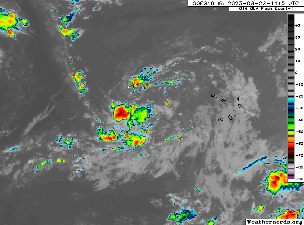
Tropical Depression Gert, east of the islands should dissipate today. Tropical Storm Emily dissipated yesterday. That is still on the big board, however, with a 20 percent chance of redeveloping in the open Atlantic as it curves out to sea.
The next system, Invest 92L, continues to plod along west of the Cabo Verde Islands. Development odds are down to 50 percent this morning, as a very slow organizational process may occur with this system. I think if it’s like most Atlantic systems this year, there’s something likely to act against it and who knows if it can truly get off the ground. We’ll see.
That covers all the noise out there right now.
Fantasyland (beyond day 10): Mired Gyre
The only other area really showing up at all on modeling as a development risk is off the Yucatan at some point on a few models (not the majority). We’ve discussed this whole gyre thing for several posts now, and maybe it comes to fruition, maybe it doesn’t. There’s enough signal in the model noise to say there’s a meaningful chance it could happen. But exactly what that looks like, I’m not sure. The overall background state of the Atlantic may actually become more hostile to tropical development in the early days of September, perhaps allowing us to catch our breath before the season finale and/or curtain call. The 2023 season to date has thus far been an example of quantity over quality which hopefully continues to be the case.
By now i don’t agree with your last statement.. I am ready for a high quality tropical storm
SMH
Can’t you just go play in a storm simulator to get your “quantity”
Those of us with empathy are thrilled with as much “quantity over quality” as we can get
Why is the eastern atlantic wave not developing? It seems to be in a good environment, why are there hardly any thunderstorms with it?
There’s definitely some inhibition out there. I’m not sure if it’s sinking air or just some dry air surrounding it or what. But as has been the case with most Atlantic systems in 2022 and 2023, there’s something holding it back.
quantity over quality is a great description
I hope it stays that way 🌬 🌧
It seems like a waste of good names when low-quality storms reach that minimum threshold to obtain one. There should be a “B” list of names for these tiny, non-destructive storms like “Snoopy”, “Pikachu”, or “Bevo”. Ya know, non-threatening, cute names.
I like this thought!
Wouldn’t the CAG storm be less than ten days?
The looks like a huge model conflict with it. Euro and it’s ensemble likes it, the GFS doesn’t. Is the Euro being too aggressive.
Really don’t want another Ida.
Really seems a bit tricky right now. Seems like we’re targeting 7-9 days at the moment now. You are correct that the ensemble support is mixed…GFS meh, Euro bullish. The Euro has been too aggressive all season everywhere I think. It has shown a lot of disturbances that just don’t form. Or really struggle. So, I’d watch it closely for obvious reasons, but I have my doubts.