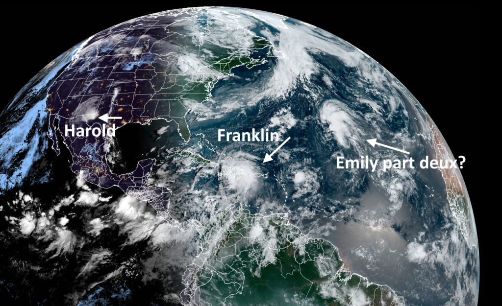
Between August 19 and 21 we saw the formation of a flurry of tropical storms—Gert, Emily, Franklin, and Harold. The first two storms remained at sea and did not affect any landmasses, although Emily may be resurrected later this week. Harold moved inland into South Texas, bringing largely beneficial rains to the Rio Grande Valley, and is now rapidly dissipating over Northern Mexico.
That leaves Tropical Storm Franklin, which is presently near Hispaniola and is a threat to bring heavy rainfall there and in other Caribbean locations. We’ll start with Franklin, and then look at what else might be lurking out in the Atlantic tropics.
Tropical Storm Franklin
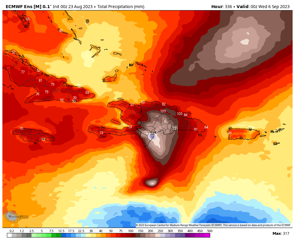
The system has improved its circulation overnight, and as of 8 am ET packed sustained winds of 50 mph. This is probably the top end of its strength for now. For the rest of today it will slowly move north, across Hispaniola, brining heavy rainfall and potentially mudslides to the Dominican Republic and Haiti. By tonight, it could also bring tropical storm conditions to Turks and Caicos.
Franklin is likely to weaken somewhat today as it interacts with the landmass of Hispaniola, and also struggles with wind shear. The intensity forecast is complicated later this week, as the system moves north of the Caribbean Sea. Sea surface temperatures are plenty hot, but wind shear could put a damper on the system. The National Hurricane Center predicts that Franklin will become a Category 1 hurricane this weekend, but my confidence in such a forecast is low.
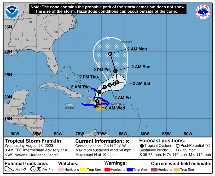
By early next week we’re going to have to watch the track of Franklin closely, as the system may come near Bermuda as it starts to meander north. Like with the intensity forecast, I would not place high confidence a in track forecast for the storm after this weekend.
Emily, zombie-fied
Do you remember Tropical Storm Emily? It’s OK if you don’t. The storm produced some gale force winds for several hours on Sunday, in the middle of the Atlantic Ocean, and then succumbed to dry air. However, the remains of Emily have started to show signs of organizing as the storm finds more favorable conditions over the central Atlantic. It has a pretty decent chance of regenerating in the days ahead.
Nevertheless, this system is not something to get worked up about. It may noodle about the Northern Atlantic as a fish storm, but I don’t think it’s going to pass near land. Certainly, we won’t see this Emily in Paris.
What else is out there?
We’re watching a few other problematic areas, but there’s nothing that gives me too much concern. Frankly, this is a pretty good place to be in as we approach the end of August and early September.
For several days we have mentioned the possibility of a system spinning up in the Western Caribbean Sea and then moving north into the Gulf of Mexico, but there’s still not a whole lot of model support for that. In fact, my concerns are lessening there. The second watch area lies in the eastern Atlantic Ocean, where we will see new tropical waves moving off the coast of Africa. Those may eventually become a threat, but as of now there’s no concrete concerns to point to.
Eric, My family and I are in southwest end of Providenciales in Turks and Caicos staying at a house. How bad would it get here? is franklin moving slow? Looks like we are on the “cleaner” side of the storm and just outside of the cone, butI know this does not mean we are out of the woods.
I look at wind map and see 5-10mph winds in light green. What about rainfall? My interpretation is we have little to worry about but I’m not sure I’m reading this correctly.
Things here appear to be very normal.
Any thoughts would be appreciated.
Hi Oscar: You should be good there. Most of the impacts should stay toward the eastern islands. Still, some locally heavy rain and gusty winds and rough surf are likely. But in terms of any preparations or anything, you should be fine as is. It’ll move off to the east/northeast tomorrow.
It’ll be interesting to see what Harold’s rain did to drought conditions in S TX and the El Paso area (and maybe NM?).
I don’t think there’s any way it’ll be reflected in tomorrow’s Drought Monitor update, so we’ll probably have to wait until August 31 to see.
To some extent. Tomorrow’s drought monitor update should factor in all precip through yesterday. Anything overnight or this morning won’t be included.
Thank you.. Appreciate your response. the winds and rain are actually nice compared to the Hell we left in Houston a few days ago.