One-sentence summary
While the Gulf or northwest Caribbean may see action next week, Tropical Storm Franklin is on its way away from the Caribbean islands and will meander north over the next few days.
Tropical Storm Franklin maneuvering north
Franklin has exited Hispaniola and is on its way north today. It is slowly trying to get its act together.
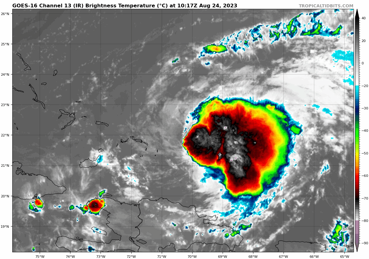
Maximum sustained winds are 50 mph, and you can see from satellite that there’s a pretty healthy burst of convection (or thunderstorms) indicated by the deep red cloud tops showing up north of Hispaniola. That said, Franklin is not yet really organized, as almost all of these thunderstorms are to the east of the center of circulation.
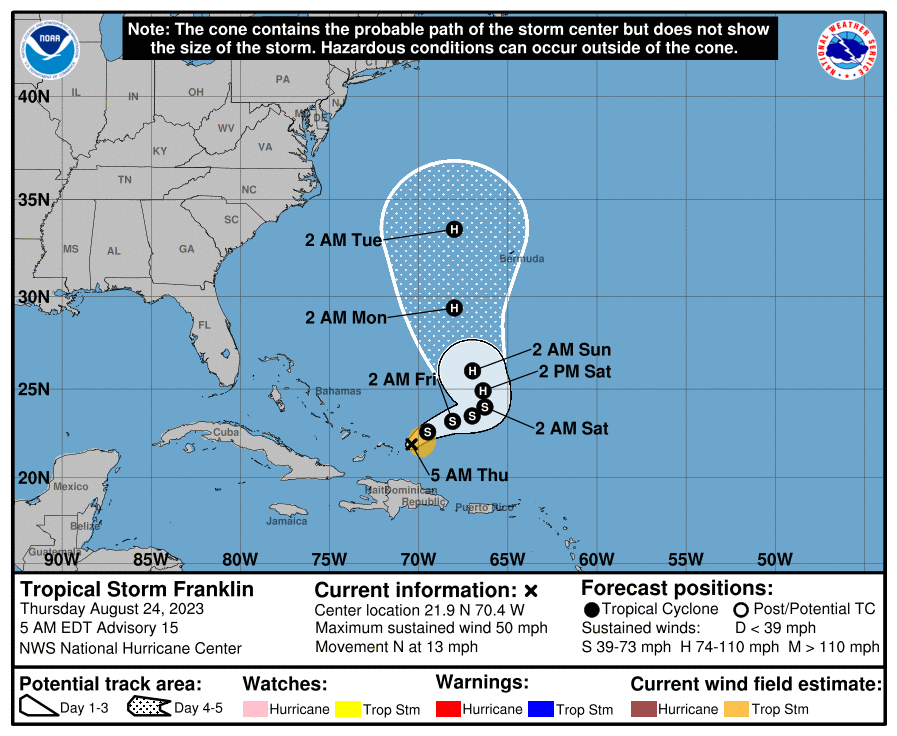
Franklin’s track is interesting but makes meteorological sense. It will continue north and turn northeast, but as high pressure builds west a little over the Central Atlantic, Franklin will slow down and turn back northwest or north, before continuing north and northeast and eventually out of the picture. The challenge regarding Franklin is that exactly where this maneuvering occurs will determine what sort of impacts are experienced on Bermuda — and for that matter, Atlantic Canada. Model consensus overnight shifted Franklin’s track a little farther west; good news for Bermuda. Folks in the Maritimes will want to monitor Franklin’s progress as it comes north next week. Anyone on the East Coast should probably expect a bit of rough surf and rip currents to become an issue later this weekend or next week as well.
We’ve seen most storms struggle this year, and Franklin has been no exception to date, but as we go into the next few days, Franklin should find a more hospitable environment in which to organize, which should lead to it becoming the season’s second hurricane.
Gulf & western Caribbean mischief
Yesterday evening, the National Hurricane Center dropped a lemon (20% development odds) on the map for the potential of development in or near the Gulf of Mexico next week. Today, that’s an orange, with a 50 percent chance of development over the next week.
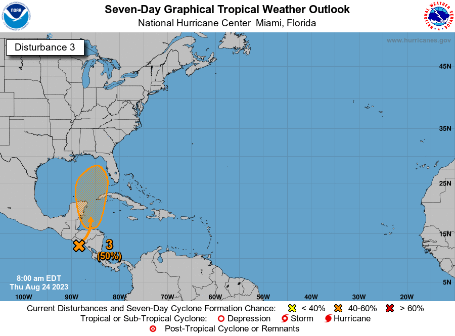
As noted in the caption, it’s important to remember that when the NHC posts these hatched development regions, they are showing what region they believe a system may form, not where it will track.
Models have been oscillating back and forth on this area for days now. The overnight GFS operational run delivered a sheared, disorganized batch of moisture to Cuba and Florida. No organization. The overnight operational European model brought a tropical storm-type system north of Tampa.
A look at the ensembles this morning shows some decent consensus that is not that different from the operational guidance: The GFS ensemble is unenthused overall, while the European ensemble is excited, though generally low-end on intensity. Remember, ensembles run each model 30 to 50 different times with some tweaks to produce a more realistic “spread” of outcomes. We need them because single deterministic (operational) models give us no real forecast uncertainty gauge. You need that, especially with tropical storms. The map below shows the two ensemble groupings and their spreads so you can get a sense of what we’re looking at.

Based on those maps, what we see in operational guidance, and what we know about the Gulf and northwest Caribbean, what can we say today?
Well, for one, we are fairly confident that whatever happens will track north and/or northeast. The weather pattern next week favors west to east or south to north moving winds over most of the central and eastern Gulf of Mexico. This should steer whatever develops (if anything) to the north and/or the northeast. So for folks in Texas and Mexico outside the Yucatan, keep tabs, but this is probably not going to be a big concern. For folks from eastern Louisiana eastward and especially in Florida, it is a good idea to continue watching. Perhaps it’s just an uptick of rain chances instead of an organized tropical system that you see next week, but it’s far too early to say which outcome is more likely right now. We will keep you posted.
Elsewhere
The good news is that there are no other items of concern for land anywhere on the board right now. Emily’s remnants continue to look likely to regenerate into a tropical storm over the open Atlantic, west of the Azores. Invest 92L still has an outside shot at developing over the next 5 to 7 days.
Hey Matt, any chance of posting a rainfall accumulation map for Harold? Thanks!
I will try to dig one up. Thanks for the reminder!
I’m surprised we didn’t see any effects on today’s Drought Monitor map. Seems like nearly 5 inches in Corpus, and 4 inches in Laredo (where their monthly normal is only 1 inch) ought to have done something. Unless it just wasn’t in time for this week’s update?
Is there any projection of when Disturbance 3 might make landfall? We are going to Orlando for Labor Day weekend so need to plan ahead. Will be watching closely.
It appears that it will occur sometime mid to late next week, likely before the weekend.
>>The good news is that there are no other items of concern for land anywhere on the board right now
With the level of drought in Texas and southern Louisiana right now, is that really good news?
Well, yeah, but given the hazards that come with hurricanes, no one should be rooting for one.
A full hurricane, sure, but I would think a depression or even a Harold-style tropical storm (as opposed to an Allison-type one!) would probably do more good than harm at this point…