One-sentence summary
We continue to expect a system to try and develop in the eastern Gulf of Mexico next week, but it will face some difficulties getting there.
Gulf development chances
The National Hurricane Center is now giving the area that’s predicted to form in the northwest Caribbean or Gulf next week about 70 percent odds of development today.
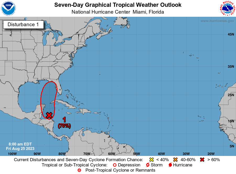
We are beginning to see a little model consensus today on this area. What are we seeing? A quick moving system that form off the Yucatan next Tuesday-ish and comes north toward the Panhandle or west coast of Florida by Wednesday. I think there are some notable questions beyond that for folks on the East Coast, whether this system goes up the coast or hooks a right out to sea. At this point, it seems like it will turn out to sea off the Carolinas, though it may sit offshore for a few days. We’ll see about that. But in terms of the first phase (a generally modest tropical system heading toward Florida), that seems to be the preferred forecast solution right now.
Much like Harold, this system will probably move fairly quickly, so it may only get 48 hours or so over water. Granted, it’s extremely warm water, but there are three issues. First, that limited time over water. Second, there will be dry air (and potentially a lot of dry air) in the vicinity of the system as it moves into the northeast Gulf. Tropical systems do not like dry air, as they can disrupt intensification and organization, especially early on. Last, wind shear is not expected to be completely shut down, so this will also be battling a bit of that as well.
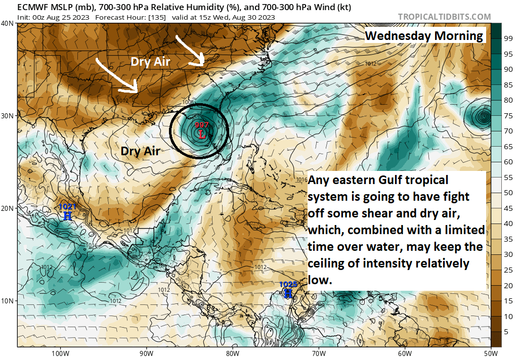
The combination of all these factors may (should?) help cap the intensity potential of this system and hopefully keep it a disorganized, steady moving rainmaker for parts of Florida and the Southeast. Given that we still have about 5 days or so before this really starts organizing, we should obviously keep an eye on it for these areas. But our initial read on this one has us optimistic it will not be a very serious storm. We’ll keep you updated this weekend.
Tropical Storm Franklin
Meanwhile, out in the Atlantic, Tropical Storm Franklin continues to struggle with substantial wind shear.
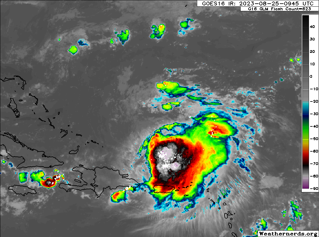
If you look closely enough, you can actually see the wind shear impacting Franklin. Despite a robust area of thunderstorms north of Puerto Rico, the center is almost completely exposed on the northwest side of all this. In other words, this is not a healthy storm. Franklin is expected to continue dealing with this shear today and tomorrow before things relax. Thereafter, it will have a chance to become our second hurricane of the season.
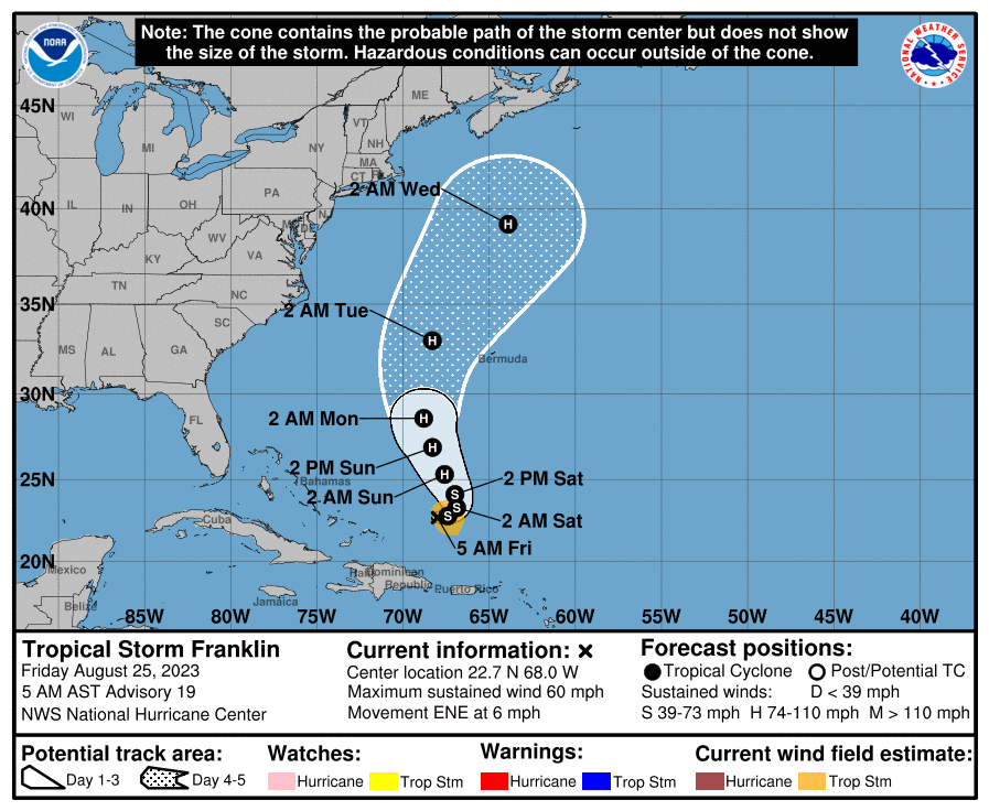
Franklin will continue to fester into tomorrow before turning back northwest, passing west of Bermuda and heading off to the northeast next week. Folks in Atlantic Canada will want to continue monitoring Franklin’s forecast, particularly in Newfoundland I think. Though Franklin is expected to weaken as it comes north, there is still some uncertainty on the exact track and intensity of it as it comes that way.
Elsewhere
Emily’s remnants are now *not* expected to develop, with odds down to 20 percent. Invest 92L still has about a 50/50 shot at development. Neither will impact land. Heading deeper into next week, we do not see anything of any real concern or note. We’ll see if any signals start showing up, but for now, it seems as if we are and remain in a fairly hostile pattern for healthy tropical systems. Good news in most cases.
Are we in a favorable for storms MJO pattern right now? Is it supposed to be more unfavorable soon?
Yes, we are technically in a favorable MJO/background state setup over the next week or so. We should then turn unfavorable for early to mid September it seems. But we’ll see how that shakes out.
Wishing everyone a safe & peaceful weekend
🌻