One-sentence summary
Invest 93L near the Yucatan is expected to develop and intensify over the coming days before lifting north or northeast toward Florida on Tuesday or Wednesday, and all interests on Florida’s west coast and Panhandle should monitor the situation.
Invest 93L should be watched on Florida’s west coast & Panhandle
Yesterday afternoon, the tropical disturbance near the Yucatan was dubbed Invest 93L, allowing meteorologists to access some new details and information on the progress of this system. This morning, Invest 93L looks disorganized but coherent near the Yucatan.

There’s no true low-level center yet it seems, but there’s enough thunderstorm activity over the Yucatan Channel off the coast to have me at least slightly concerned we could see development start sooner than later. At the moment, 93L is in a decent spot for development, with its proximity to land being the only real inhibiting factor. Over the next few days, this environment should remain fairly healthy for organization. If this can get off the ground later today or tomorrow, it will have a chance to become a formidable system as it comes northward. One big reason why? Water temperatures. All summer we have discussed how warm the Gulf is, and this remains the case today.
As 93L comes north, it will have this water to utilize for strengthening. We need more than warm water for tropical systems, but this is a key ingredient. If it becomes an organized entity sooner than later, there’s a chance it will be able to more effectively use this warm water. If it stays disheveled coming north, it may not be able to use this as considerably. That’s why the next 36 hours or so are important.
In terms of track, Invest 93L will basically just percolate for the next 36-48 hours off the Yucatan. There’s nothing right now to really move it along. So that’s one reason we’re concerned about strengthening. By the time we get to Monday and Tuesday, it will finally get a push north and, broadly, it will move north or north-northeast toward Florida.
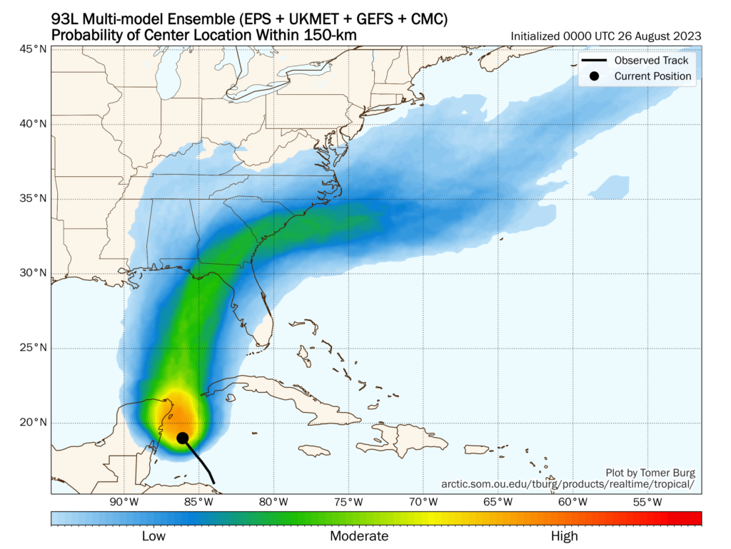
The current highest odds aim toward the Big Bend region of Florida or toward Apalachee Bay. However this is going to likely maneuver around some in the coming days as we see what 93L’s intensity does.
So we don’t know a whole lot other than, broadly, what 93L should do: Steadily strengthen and work toward the west coast or Panhandle heading into next week. What we do know is that 93L looks coherent this morning, it’s over some of the warmest, deepest warm water in the Atlantic Basin in and environment that should be conducive for strengthening if it can avoid too much land interaction. I am a bit less skeptical of this system today, and it really does bear close watching for anyone on the west coast or Panhandle of Florida. Interests in western Cuba as well as the Mobile/Pensacola area should also be keeping an eye on this one as well. We’ll see how things go today and have more either later or on Sunday morning.
Quick note: We know some people have travel in or will be traveling to Cancun or Cozumel or in this general area. No serious impacts are currently expected there beyond rough surf and some added rain. If, however, 93L can catch a heater and develop quickly, some more impacts may occur on the immediate coast. We’ll keep tabs.
Hurricane Franklin
Franklin just became the second hurricane of the 2023 season this morning. Since yesterday, it has gotten its act together quite nicely.

Franklin has 75 mph winds and is moving north-northwest around 7 mph. Franklin should pass comfortably west of Bermuda before turning back northeast. As it turns out to sea, there is still some chance it clips Newfoundland on the way out, so interests there should monitor Franklin’s progress over the next 2 to 3 days.

Franklin should become a major hurricane tomorrow or Monday as it passes southwest of Bermuda. No direct land impacts are expected from Franklin, but rough surf and rip currents are likely along the East Coast and in Bermuda this week as Franklin passes offshore. Please use caution if you’re getting a jump start on Labor Day Weekend.
Otherwise, we’re good for now, and the majority of our attention will remain on the eastern Gulf of Mexico. More later or tomorrow. Check our social sites for a video update later today.
The GFS has been showing a tropical system heading west in the Caribbean next weekend. Should we be concerned or is this noise?
Long range model runs are not always reliable TGR, it will change each day
Noise at this point.
Yeah, it doesn’t match the GEFS models, but the 12z ECENS and the uptick in ensembles for it does make me think we need to watch this wave in the Caribbean.
looks like the heat dome helps deflect another one from TX
*sending good thoughts to NE Gulf*
🌺