One-sentence summary
Invest 93L was upgraded to Tropical Depression 10 this afternoon, and it is likely to impact the west coast or Panhandle of Florida as a hurricane on Tuesday or Wednesday.
Tropical Depression 10
As of Saturday evening, Tropical Depression 10 was spinning in or just south of the Yucatan Channel and off the coast of the Yucatan.

TD 10 has a well defined center it appears and a pretty healthy circulation about it as it spins, mostly in place due to the absence of any real steering currents in this area. Heavy thunderstorms are displaced well east of the center over western Cuba and the Isle of Youth.
At present, we have tropical storm warnings from Rio Lagartos through Cancun and Cozumel south to Tulum on the Yucatan, and there are tropical storm watches in effect for the Isle of Youth and Pinar del Rio in Cuba. Warnings mean tropical storm conditions are likely, while watches mean they are possible. We are still a day or so away from watches being issued in Florida I believe.
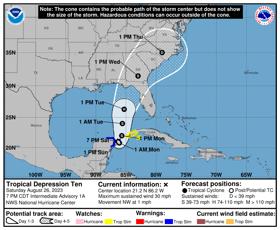
Tropical Depression 10 will stay in place much of tomorrow before drifting northward on Monday and then picking up the pace Tuesday. Broadly, it still is expected to track toward Florida, be it the Panhandle or the west coast. Modeling is focused on this tracking close to the NHC map above, near the Big Bend of Florida. However, given that there is a bit of uncertainty in terms of how the center behaves in the next day or two, everyone from the Alabama coast through the Keys and Cuba should be monitoring Tropical Depression 10’s progress. The next name on the list is Idalia.
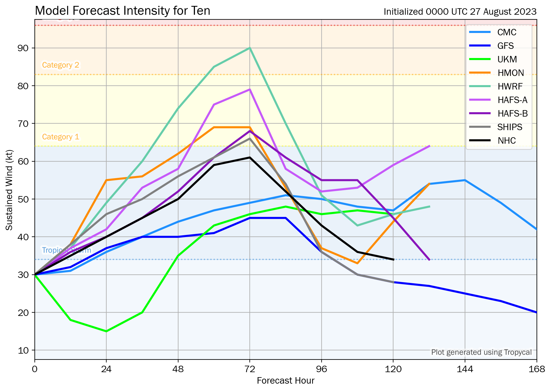
In terms of intensity, the NHC forecast above explicitly shows a 75 mph category 1 storm heading into the Panhandle or Big Bend. However, there is reason to believe that modeling and forecasts may be somewhat underdone. Water temperatures along the path of TD 10 will be very, very warm and that warm water is very deep as well, so this will have much fuel to feed off of. If wind shear or dry air get involved, this could limit the storm’s intensity some, but probably not entirely. Land interaction is also a wild card over the next day or so near the Yucatan, so the intensity forecast is a bit uncertain. I would anticipate at least a low-end hurricane, however, on the Florida coast by Tuesday night or Wednesday morning.
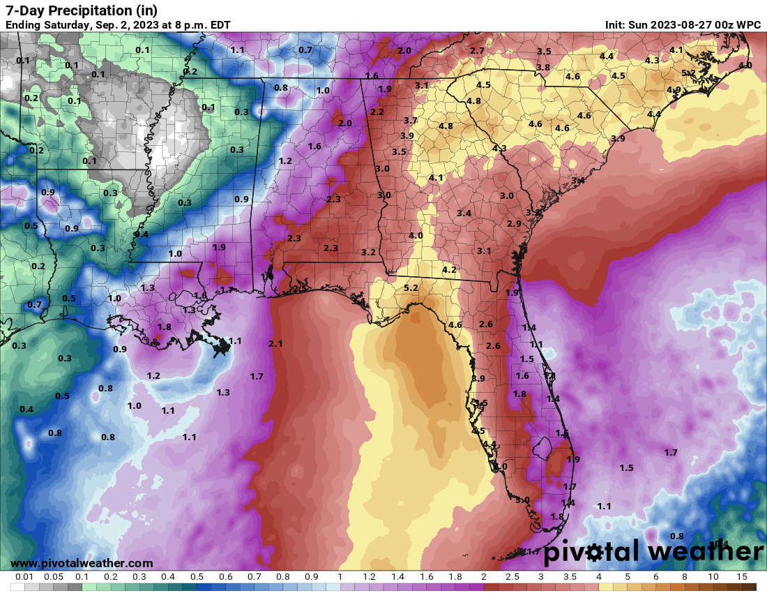
In addition to tropical impacts on the Florida coast, this is looking like a healthy rainmaker for Florida and the Southeast. Anywhere from 4 to 6 inches of rain are possible along and to the east of the path of TD 10 in Florida, and higher amounts are likely in some places depending on exactly how things play out. The rainfall distribution may change some once the storm ends up in the Southeast, with a widespread heavy rain possible, if not likely for parts of Georgia and the Carolinas. Details on this will get ironed out in the coming days.
Again, like much of everything regarding TD 10, you can anticipate forecast changes to the above map.
The bottom line:
- Tropical Depression 10 is forecast to impact the Florida Panhandle, Big Bend, or west coast as a hurricane this coming week.
- The intensity of TD 10 at landfall is highly uncertain, but folks in Florida in the cone should be preparing for at least category 1 type hurricane impacts.
- The exact landfall and track remain uncertain.
- Heavy rain will likely follow TD 10 northward, potentially leading to some flooding issues in parts of the Southeast from Florida into Georgia and the Carolinas.
We will have another update on Tropical Depression 10 and the rest of the tropics by about midday Eastern time on Sunday.