We’re a couple days late this week, but that’s ok. It’s Wednesday, November 18, only 8 days til Thanksgiving, so let’s take a look at what’s interesting in the world of weather. And it is interesting
Florida flooding
Hurricane season doesn’t always end with a whimper. Sometimes it ends on a sloppy note. And this may be one of those years. The National Hurricane Center has been latching onto a potential area of development near the Florida coast in a couple days.
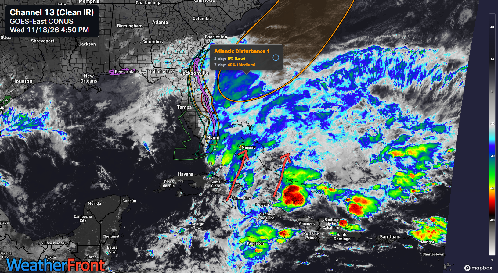
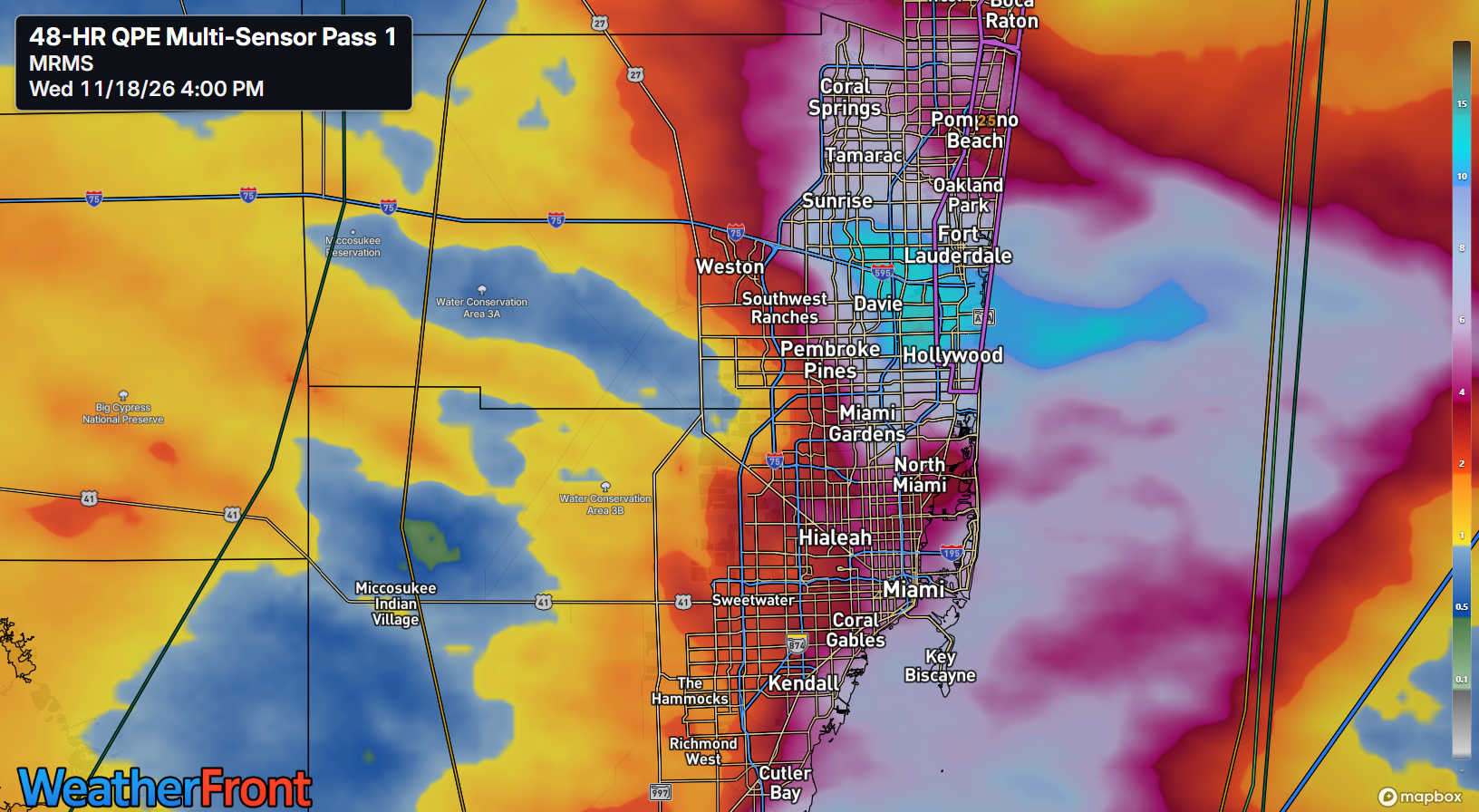
This has already caused problems. Onshore flow has been piling in moisture from hundreds of miles out in the Atlantic to Florida, and it’s only going to become more prominent in the coming days as the Florida equivalent of what is basically an atmospheric river takes shape. Here’s how it unfolds. First, easterly flow into Florida builds up moisture. This has already caused issues with localized heavy rain between Miami and Fort Lauderdale that has piled up to 10 inches or more in spots near Hollywood.
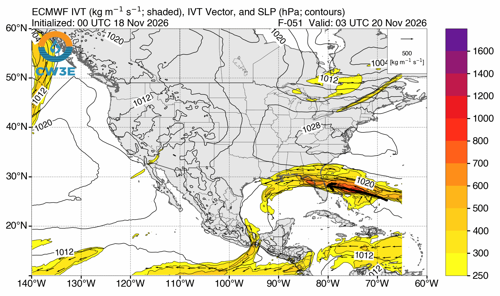
This easterly “fetch” as we call it in meteorology will continue. In fact, by the time we get to tomorrow night, you can look at one of our key tools for forecasting Western U.S. atmospheric rivers, a vertically integrated water vapor transport map, and you can see that broad fetch of moisture coming in from way out in the subtropical and tropical Atlantic.
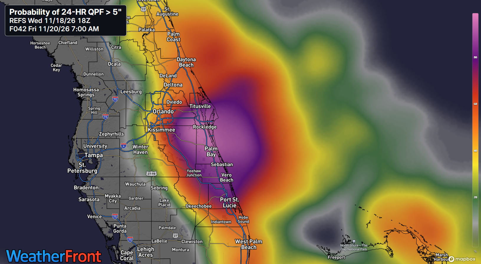
Low pressure at the surface should begin to spin up tomorrow night near the Bahamas and drift northward Friday. As this occurs, we’re going to see what probably ends up being a somewhat narrow but intense band of rainfall setup over the Florida Peninsula somewhere south and east of Orlando. The latest REFS ensemble mean probability of 5 inches or more of rainfall in the 24 hours ending at 7 AM Friday (so, tomorrow) is centered on Melbourne and Palm Bay, but there’s decent odds anywhere between St. Augustine and West Palm Beach if we’re being honest.
Either way, tomorrow looks extremely wet. Flood Watches are posted from Jacksonville through the southern tip of the Peninsula, and the WPC is highlighting that Space Coast area for a moderate risk (level 3 of 4) of excessive rain and flash flooding on Thursday. By Friday, additional heavy rain is likely, perhaps farther up the coast toward Jacksonville.
It’s from this point that questions sort of develop with respect to the low pressure off the coast. If it develops into a more organized tropical or subtropical storm, we could see moisture linger more over the open ocean Saturday and Sunday before that system drifts northward to the Carolinas. If this remains a strung out mess, we could see a “spray” of heavy rain and flooding risk expand up the coast into Georgia, South Carolina, and perhaps even North Carolina. Google Deep Mind is less enthused about this organizing into a formal tropical entity than some other modeling, the Euro in particular.
(As an aside, this will be an interesting test for the Google WeatherNext model, as this is basically the first out of season system we have had since the model took over the tropical world. Sometimes weather models don’t perform the same in transition seasons as they do during the primary season, and if we’re looking at a particularly out of sample event like a stronger tropical storm off the Florida coast in late November, there’s some inherent risk that it will “miss” this. But we’ll see.)

When all is said and done, we’re probably looking at about 4 to 8 inches of rain along Florida’s east coast, with pockets of 8 to 12 inches possible. These rains have potential to be quite torrential in spots and slow moving, so this is a relatively higher end rain and flooding event for Florida, even by Florida’s normally high standards for these things.
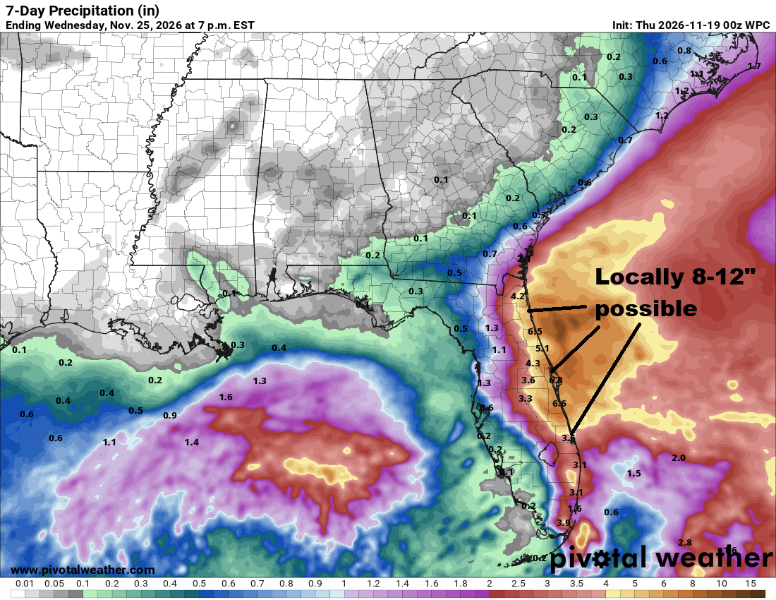
Farther up the coast, the rain should not cause as many problems, but if a tropical system does indeed develop offshore, this could be problematic for the Outer Banks, where Route 12 is in the news and is likely to stay in the news throughout this likely active winter.
Beyond this? A parade of additional storms is likely on the East Coast between Thanksgiving and early December. How these impact Florida, if at all, remains to be seen, but there is no sign that an active pattern is going to slow down anytime soon.
We’ll check in on the West Coast later.