One-sentence summary
Hurricane and storm surge watches are now posted along much of Florida’s west coast and parts of the Panhandle as Idalia is expected to bring impacts by Tuesday.
Tropical Storm Idalia
Tropical Storm Idalia (pronounced “ee-DAL-ya” for those that were not sure) formed this morning, and quite frankly it looks no better organized now than it did then. So in essence, not a whole lot has changed from our morning post.
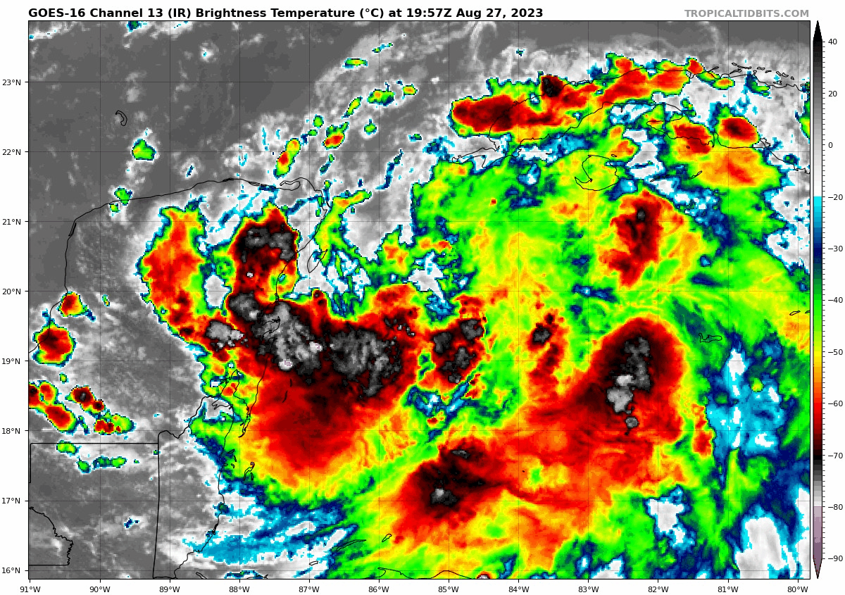
This was mostly expected. Idalia is unlikely to really get moving in terms of intensity until it start getting a lift north, meaning a lot of the intensification we see from this storm may not occur until it’s rather close to land. Idalia is not exactly a small system, with thunderstorms extending from the Yucatan to east of the Isle of Youth in Cuba, which is about 400 to 500 mile wide swath of unsettled weather. To underscore, while the track of Idalia does matter, one need not be close to the center to feel the impacts of this storm as it comes north.
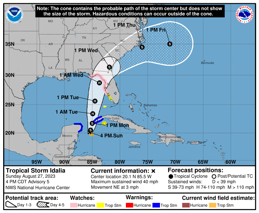
The track forecast today has not seen any dramatic changes, so, broadly we still expect a hurricane approaching the eastern Panhandle, Big Bend, Nature Coast, or Tampa area by Tuesday night. Again, given the size of Idalia and the geography of Florida, hurricane impacts may touch the coast well south of wherever Idalia comes ashore. So, it’s entirely conceivable that (hypothetically) Idalia makes landfall, say, near Cedar Key, while producing hurricane impacts as far south as Sarasota.
Indeed, the biggest change this evening is that we now have a broad swath of the Florida coast under Hurricane Watches and Storm Surge Watches.
Storm Surge Watch: Indian Pass on the Panhandle south to Chokoloskee on the southwest coast.
Hurricane Watch: Indian Pass south to Englewood, between Sarasota and Fort Myers
Tropical Storm Watch: Englewood south to Chokoloskee and for the Dry Tortugas.
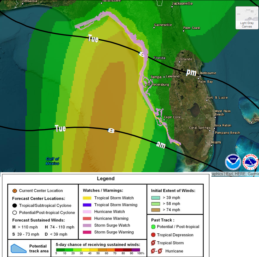
On the map below I have overlaid the watches for Florida, in addition to the probability of 60 mph winds and the most likely arrival time of those tropical storm force winds. You can see how wide the berth is for potential strong wind.
The storm surge forecast from the NHC is somewhat aggressive, and it seems warranted given Idalia’s current forecast intensity. The map below shows the reasonable maximum surge above ground level in the impacted areas.
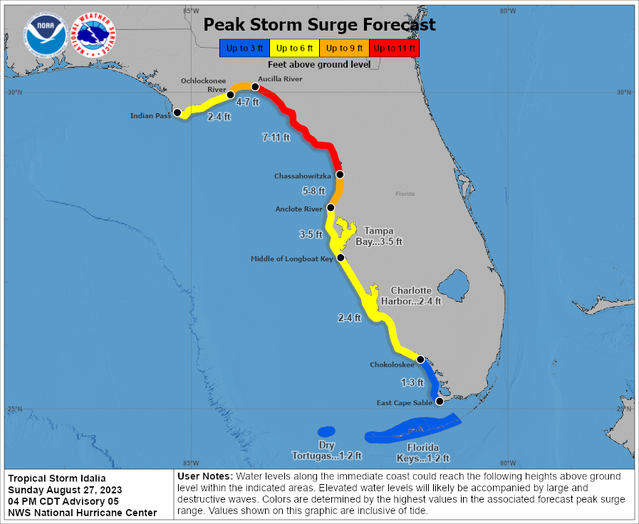
One important note: During Irma and last year during Ian, because of the wind direction, surge was directed out of Tampa Bay. With Idalia currently forecast to pass west and north of Tampa, this would direct surge *into* Tampa Bay. So please don’t go storm chasing this to see a dry Tampa Bay. Another important note: As Idalia’s forecast is revised, this forecast will be revised too, and you should be following forecast progress closely. Florida’s geography and the unique interaction with storms coming from this direction can lead to some substantial forecast impact changes with surge in particular.
So, for folks along Florida’s west coast, the Big Bend, and parts of the eastern Panhandle: You will need to be ready for potential hurricane impacts, regardless of exactly where Idalia comes ashore.
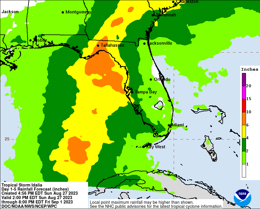
The rainfall forecast has not changed a ton. Idalia keeps moving at a good clip once it gets north of Florida. While this will by no means prevent flooding in spots, it does help to probably limit flooding concerns a bit. We’ll watch the situation in Carolinas a bit closely, as some heavy rain will front run Idalia today and tomorrow, and flood watches are already posted in eastern North Carolina. If I were watching some place closely for flooding risk, it would be there right now.
So, to summarize:
- Idalia is still forecast to become a hurricane as it comes north into Florida Tuesday night.
- Storm surge and hurricane watches are posted along much of Florida’s west coast indicating that surge and hurricane conditions are possible.
- The forecast storm surge will be contingent on exactly where Idalia comes in but a substantial surge event is possible for the Nature Coast and Big Bend. Folks in Tampa Bay should watch this closely as well.
- While portions of SW Florida impacted so badly by Ian last year are unlikely to take a direct hit from Idalia, there will likely be impacts there from high water, rough surf, and some gusty winds and some vulnerable portions of the waterfront still not fully recovered may see some issues.
- Heavy rain will follow Idalia inland and North Carolina may be in line for the greatest inland flooding risk as it stands right now.
- The forecast IS going to change in the coming days so check back for more.
We will have our next update for you as usual on Monday morning.