One-sentence summary
Hurricane Lee is on track to impact New England and Atlantic Canada this weekend, a significant storm capable of a serious storm surge and widespread winds.
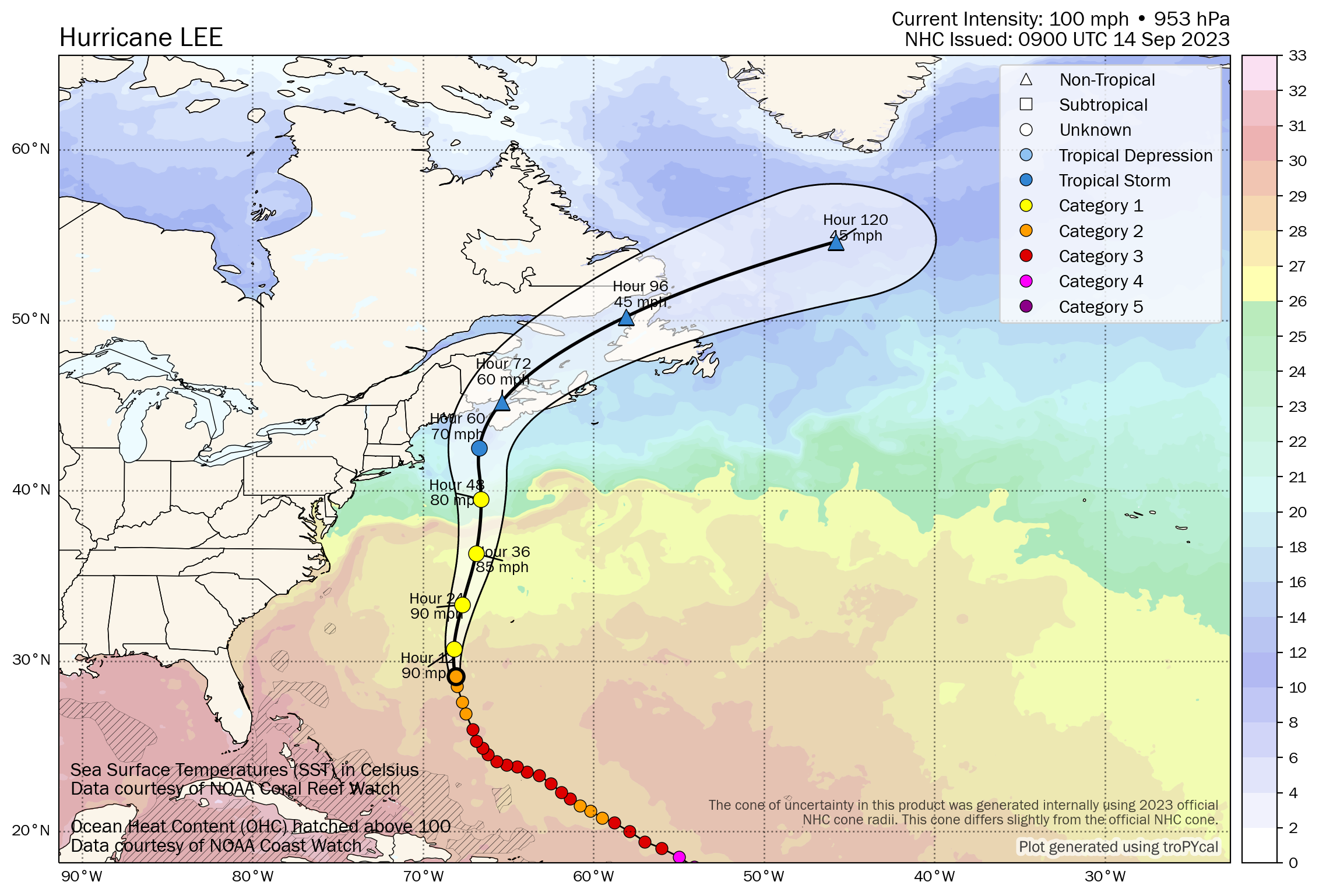
Hurricane Lee: 100 mph, moving N 9 mph
What’s changed since Wednesday evening?
A Hurricane Watch is now in effect for portions of extreme southwestern New Brunswick, as well as southwestern Nova Scotia. Tropical Storm Watches connect the two Hurricane Watches and also extend east across Nova Scotia past Halifax.
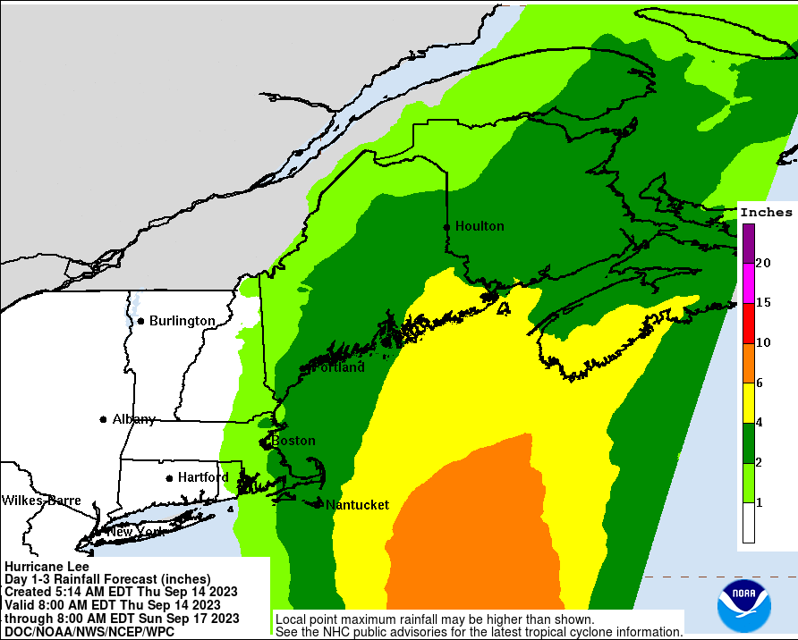
The rainfall forecast was nudged up a little for southeast Maine, southern New Brunswick, and southwest Nova Scotia.
Lee’s forecast track
For the most part, the track forecast is now baked in up to landfall. There may be some wobbles in terms of exactly where Lee ends up, but it’s narrowed to most likely between Eastport, ME and about Cape Sable Island.
Atlantic Canada surge impacts update
For Canada, we continue to worry most about surge, particularly with a storm that would come right into the Bay of Fundy, without making landfall on Nova Scotia. Essentially, large amounts of water would be funneled into the Bay. Saturday’s low tide in the bay is around 7:30 local time, with the subsequent high tide at 1:45 AM Sunday. That high tide may be the worst tide of the event for the Fundy coast of New Brunswick. Surge will extend far to the east of the center though, and a substantial surge may occur along much of Nova Scotia’s coast as Lee comes in.
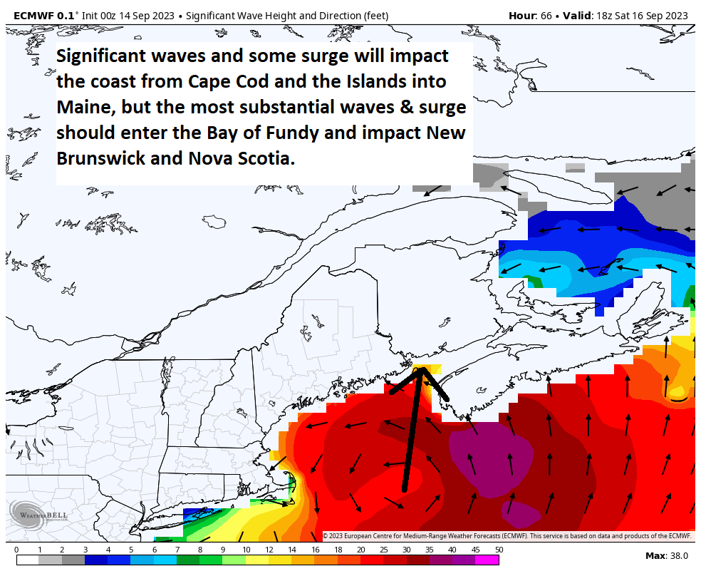
Again, it’s important to note that the most significant hazards will differ from those of Fiona last year, which tracked into eastern Nova Scotia. And the surge impact from this storm and the wind field of this storm will be broader and wider spread than most storms. This is a serious storm and should be treated as such.
Massachusetts outlook
Yesterday we noted that the one primary area of uncertainty may have been Cape Cod and the Islands, as the approach of Lee from the southeast would determine how much wind, rain, and surge we saw there. Lee is now expected to pass about 100 miles or so east of the Cape and Nantucket. This should offer up tropical storm force wind gusts, as well as at least some heavy rainfall to those areas.
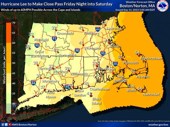
The strongest winds should stay offshore, and aside from the 2 to 4 foot surge and moderate coastal flooding, this will likely behave more like a strong nor’easter than anything for southern New England.
Still, folks in these areas should continue to monitor forecast changes, particularly around the surge forecast to ensure that they’re up to speed on the latest. We’ll have a little more detail on the Maine and coastal New Hampshire outlook later this afternoon.
Lee’s wind and rainfall outlook
Changes to the wind and rainfall sections of our post yesterday were minimal. We are still expecting broadly the same outcomes from those regardless of whether Lee is a hurricane, tropical storm, or post-tropical. The rainfall forecast was nudged up a bit, however, with some areas now seeing more like 4 to 6 inches of rain.
We will have another post with the latest on any changes late this afternoon or evening.
Elsewhere in the tropics
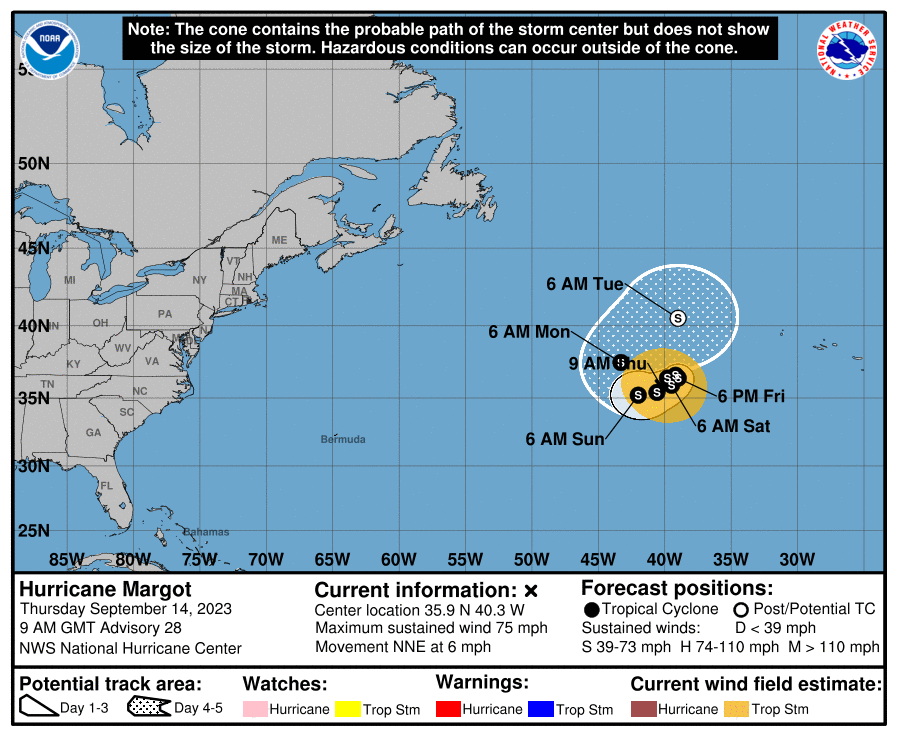
Hurricane Margot has had a bit too much Sauvignon blanc and is basically doing loops southwest of the Azores. It remains no real threat to land for some time, though at some point I suppose it could approach the Azores.
Invest 97L continues to look poised to soon develop and track out over the open ocean. Perhaps eventually Bermuda will need to watch this one, but that’s a long way off yet.
There are no other concerns beyond those systems.
Y’all are the bomb!!
Thank you for the great updates!!
Keep ‘em comin’!!
Thanks!
Sauvignon Blanc. Good one!!
The pattern continues to be closed for west gulf activity. It looks like 2023 is an off year for our area. When we get our first good front to come on down,we can pop the corks on skating this season unscathed.
Amen, though I don’t know when that first front is coming! And that makes me bummed.