One-sentence summary
Hurricane Idalia is expected to make landfall in the morning as a category 4 major hurricane, bringing catastrophic storm surge to the Florida Big Bend region and Apalachee Bay, an unprecedented storm in modern history for this region.
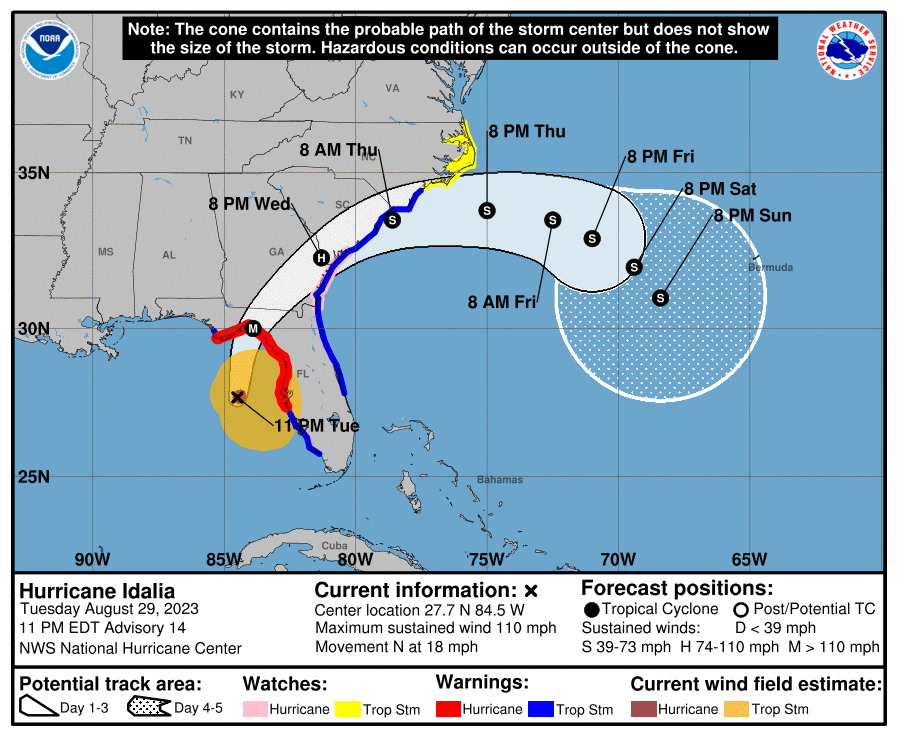
Hurricane Idalia: 110 mph, moving North at 18 mph
As of the 11 PM ET advisory, Idalia is on the cusp of becoming a major category 3 hurricane. Idalia is beginning to take on “the look” when you look at satellite imagery. Unfortunately, if you’ve watched the Gulf since 2017, when a storm takes on “the look,” it usually means the forecast of a major storm with major impacts will verify. We’re in that boat tonight.

What’s changed since late afternoon?
A few notable changes: First the storm track has shifted the landfall point even a little farther west, now in the middle of Apalachee Bay. This has implications on Tallahassee discussed below.
Second, storm surge heights have increased. They are now as high as 12 to 16 feet above ground level in the eastern portion of Apalachee Bay and the Big Bend. Basically St. Marks to Yankeetown is likely to be completely inundated with deep water. Surge heights are slowly being trimmed back on the southwest coast of Florida up through Tampa as Idalia accelerates north.
Surge forecasts have been added for North Carolina now, with perhaps as much as 2 to 4 feet in some of the mainland shores of Pamlico Sound, as well as near Cape Lookout.
Surge update
Catastrophic surge is expected in the Florida Big Bend. Not much else to say here. There’s been little change since earlier this evening in terms of this impact. The forecast has shuffled a bit with 12 to 16 feet of surge now as far west as the Wakulla/Jefferson County line, just east of St. Marks. We continue to believe this will come into an area with no real modern historic precedent of this level of hurricane hitting (best comp perhaps being in the late 1800s).

This is the last warning folks in the relatively rural Big Bend have to get out. These smaller communities will need a lot of help in the days ahead.
Wind update
The core of strongest wind is expected to be just east of Tallahassee across much of the Big Bend into much of north-central Florida and far south Georgia. Live Oak, Lake City, Alachua, and Valdosta may all see significant hurricane-force winds. Considerable wind will also be possible as Idalia moves into Georgia, so communities like Waycross, Kingsland, or even Brunswick could see strong winds.
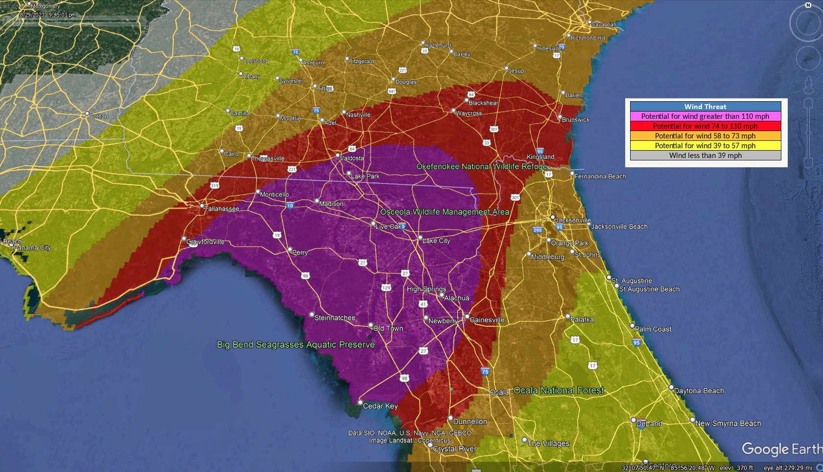
The exact location of these strong winds may maneuver a little west if Idalia’s track shifts any farther that direction.
Tallahassee
For the city of Tallahassee, the track of Idalia has not trended kindly today. The slight nudge west today has kept Tallahassee in play for the western eyewall of Idalia as it comes ashore. What does this mean? It means that most of the city will either see generic damaging winds (hurricane-force gusts, mostly) or sustained hurricane-force winds and widespread damage potential. There may even be a relatively noticeable east to west gradient of damage, with more of it on the east side and less to the west. We’ve gotten no real additional clarity tonight on exactly how close that will come, but suffice to say, it will be close.
Rainfall from Idalia
Idalia is expected to be a pretty healthy rainmaker as it comes north. Flood watches extend from Florida into North Carolina now. There will be corridor of 6 to 10 inches of rain up the coast, just inland, basically along and west of I-95, depending on exactly how Idalia tracks.
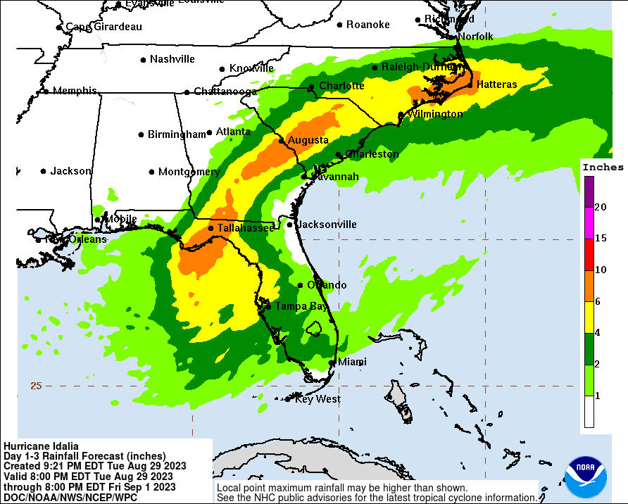
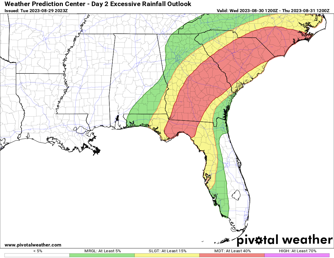
I think North Carolina bears some watching, as there is a sign in some modeling for an area of enhanced rainfall from about Cape Hatteras south and west onto the mainland near New Bern where amounts toward the higher end of the forecast range are possible. The Weather Prediction Center has a “moderate” risk (level 3/4) for this region for excessive rainfall and flooding for Wednesday.
Thankfully, Idalia should be moving offshore by Thursday morning, ending the rain threat in the Carolinas and Georgia.
As is always the case, isolated tornadoes do occur with landfalling tropical cyclones, and Idalia should be no different. The highest chances of a tornado would be in North Florida, coastal Georgia or coastal South Carolina.
Charleston, Savannah, and Jacksonville
We continue to monitor the risk of storm surge and coastal flooding in some of the larger metro areas on the Atlantic coast, in particular Charleston, Savannah, and Jacksonville.
For JAX, this should be hopefully mostly a nuisance event, with wind gusts to 50 mph and about 1 to 3 feet of surge. This would produce mostly minor to moderate flooding in the Jacksonville area.
In Savannah, winds could be stronger, as it will be closer to Idalia’s center when it comes by, so gusts of up to 70 mph are possible there. In addition, up to 4 feet of water above ground level is possible.

The 10.3 foot forecast at the Fort Pulaski tide gage would be the highest since last November’s 10.41 foot level. This is associated with moderate coastal flooding.
In Charleston, the Harbor is still forecast to get to 8.3 feet, which qualifies as “major” tidal flooding. Of course, coastal flooding is a scourge in Charleston, and this level was achieved as recently as June of this summer.

Charleston should see wind gusts as high as 60 mph with Idalia as it passes by, which may in combination with heavy rain complicate drainage of water a bit, making this tidal level a little worse than what would normally be expected with 8.3 foot tides.
The second act
Once again, I just want to close out on this: Don’t worry about the second act of Idalia, as some models show it looping back toward Florida heading into next week. It’s simply not a relevant concern at the moment and the storm would likely be a shell of itself if it happened that way. We are not concerned right now about this coming to fruition in a serious manner. The focus should be on impacts tonight and tomorrow.
Our next post will aim to come at you around 7:30 AM ET Wednesday.
Guys, you do such a great job! Love SCW and think the Eyewall is awesome for the Gulf Coast. I’ve shared this site with family and friends in Louisiana and Florida. I have a FL friend who has stayed tuned in here for Idalia coverage, and her only comment was that she wished there had been a few more updates in the lead up. No criticisms, just comments / suggestions as you grow the site. Thanks for all of the hard work.
Thank you!! We agree. We probably needed to post a couple more times yesterday and Monday. But we’re learning too! Thanks to you and all for reading!
I just wanted to say, thank you! I moved from Houston to Florida this year and was thrilled that you all expanded your coverage. I have been recommending you to all of our family here. Your assessment of Idalia was critical for us. God Bless you all and we are hoping you all get some rain over there soon!
Thanks, James!