One-sentence summary
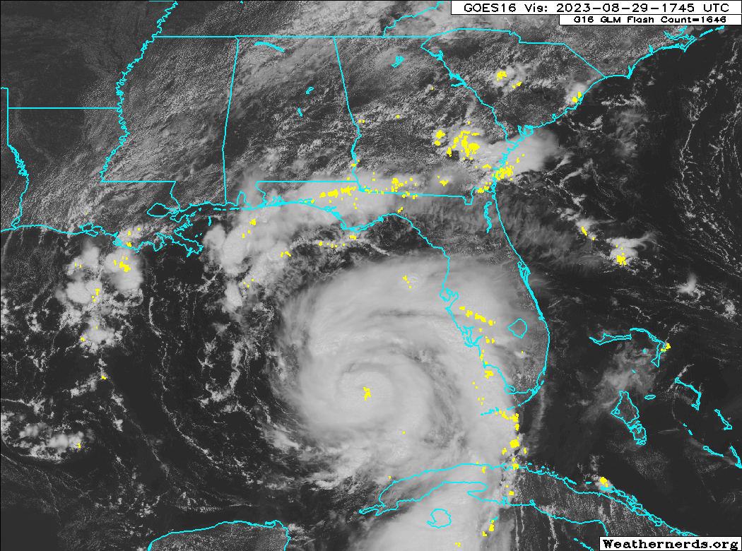
Idalia is steadily strengthening today and is expected to come ashore as a major hurricane tomorrow morning somewhere in the Big Bend of Florida or Apalachee Bay with catastrophic storm surge and damaging wind potential increasing for Tallahassee.

Hurricane Idalia: 100 mph, moving N 16 mph
The bottom line on Idalia this evening: A catastrophic storm surge impact is expected in the Big Bend and Apalachee Bay from a major hurricane tomorrow morning. In addition, strong winds will buffet the west coast of Florida along with surge up through Tampa to the Big Bend as well. Tallahassee is now going to come close to getting into the western eyewall of Idalia as it moves inland, which could lead to wind damage and widespread power outages. Idalia will continue producing wind and rain impacts into south Georgia with coastal flooding up the Georgia and South Carolina coasts as well.
What’s changed since this morning?
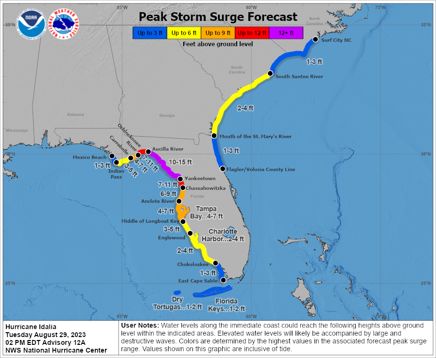
A few things. First, the general forecast remains on track. The landfall point has nudged a bit farther to the west, which introduces the risk of catastrophic surge to a wider portion of Apalachee Bay. We are now looking at 3 to 7 feet on the west side of the bay and 10 to 15 feet on the east side into the Big Bend.
More on surge in a moment.
Tropical Storm Warnings extend up into North Carolina (Surf City) now with TS Watches posted north of there to the Virginia border. Hurricane Watches remain for the coast of Georgia and South Carolina up to Edisto Beach. Hurricane Watches were dropped on the west coast from Englwood to Longboat Key, and the Storm Surge Watch was dropped south of Bonita Beach, FL.
Another big change today has been the westward nudge likely putting Tallahassee in play for potential eyewall winds tomorrow morning as Idalia comes ashore. Using the GFS operational model as our guide, we can annotate roughly where the strongest winds *should* go at present.
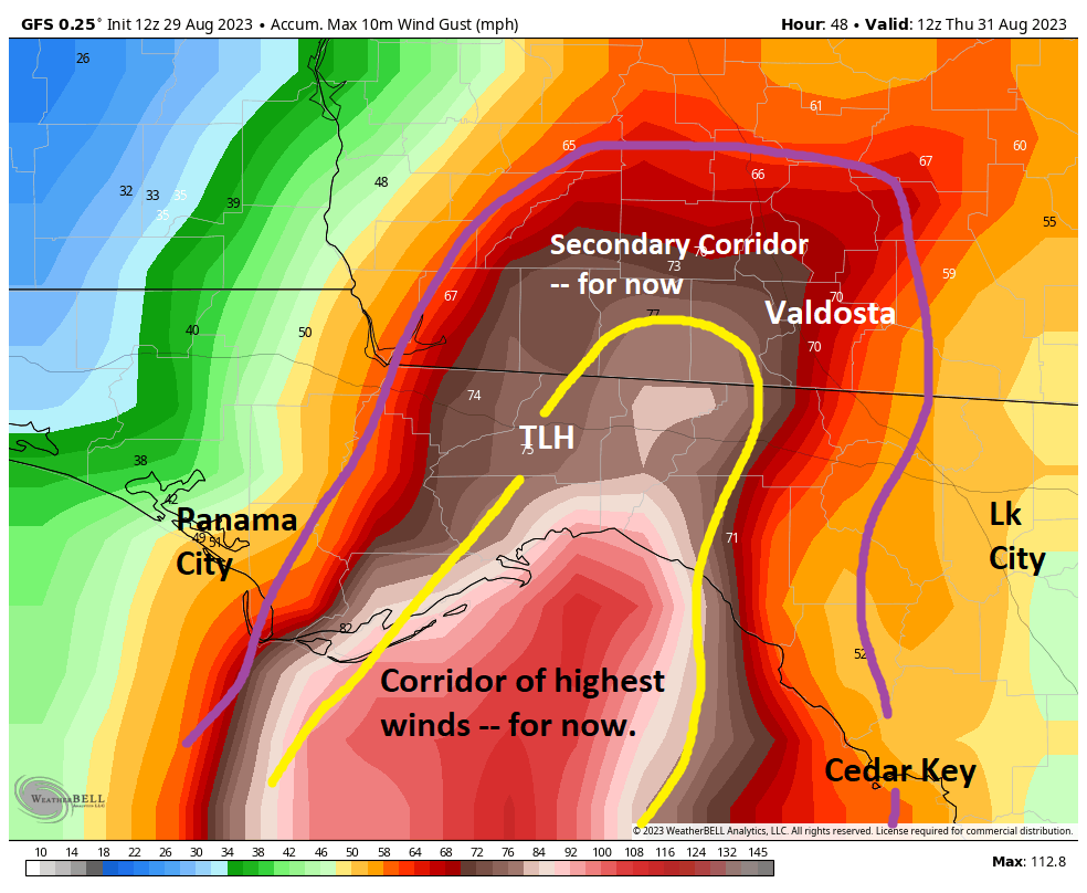
Tallahassee is currently right on the edge of the stronger winds as Idalia comes ashore. This will probably be a close call between hurricane-force gusts and widespread hurricane-force winds with significant damage. Prepare accordingly. Anywhere that sees the strongest wind could see multi-day power outages.
Other notes on Idalia in Florida and South Georgia
We discussed Tallahassee above. Tampa Bay will likely see 4 to 7 feet of surge and at least tropical storm force winds. This will cause serious flooding around the bay and along the coast. Please heed the advice of local officials tonight and tomorrow.
For interior and eastern Florida, this actually looks a bit less impactful now. We are seeing bands with isolated tornadoes and gusty winds. But for places like Orlando and Miami, it should not get too much worse. For Jacksonville, that area will see winds pick up tonight and tomorrow as Idalia passes by to the north and west. Wind impacts will be most significant west toward Lake City and north toward Waycross, GA and Brunswick, GA. Minor surge impacts are possible on the First Coast, with slightly higher surge impacts in Georgia (2 to 4 feet).
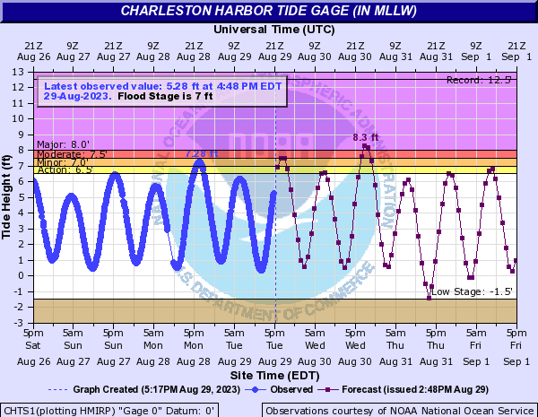
For Savannah moderate flooding is expected, but for Charleston, SC major flooding is forecast.
Along the Georgia and South Carolina coasts, as well as near where Idalia comes ashore in Florida, water levels could be locally higher than forecast due to heavy rainfall as Idalia comes in, preventing water from being able to drain.
More on surge
The amount of water that is expected to inundate portions of Citrus, Levy, Dixie, and Taylor Counties is catastrophic. The National Hurricane Center spends a lot of time deliberating when to use that word, but they chose it for this storm. Given that there is no modern history of a storm of this magnitude coming ashore in this area, there is no precedent for what is going to occur here. That’s a terrifying inundation map from this morning, which shows surge possibly going *well* inland from the coast in the Big Bend.
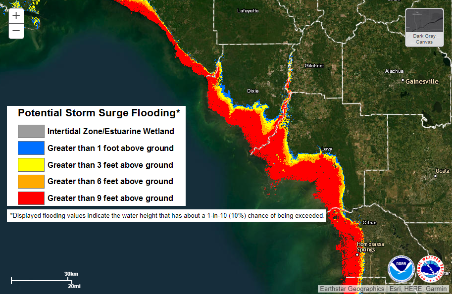
The map above shows the scenario that has a 10% chance of being exceeded. This is somewhat of a worst-case scenario type map, but it gives you the right idea. You do not want to be on the coast or a few miles inland in the Big Bend. Surge impacts west of here will also be bad for Apalachee Bay, but less severe than this. Regardless, this is truly catastrophic surge coming to the Big Bend and east side of the bay.
Idalia’s exit
We still anticipate that Idalia will weaken to a tropical storm over Georgia and South Carolina, and it should exit the coast somewhere between Wilmington, NC and Savannah, GA depending on the exact track of the storm. From there, all bets are off in terms of track. We do expect wind shear to become a severe issue off the East Coast, so that should keep any reintensification of Idalia in check. I would not spend much time worrying over a second act of Idalia at this time. We’ll keep you posted. We’ll update once more later this evening and again in the morning. Look for a video update on our social channels this evening.
Editor’s Note:
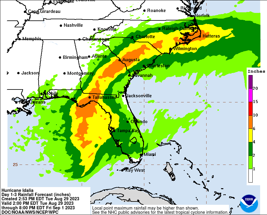
I neglected to discuss rain before hitting publish. Here’s the latest rain forecast. Our late evening post will take a closer look at this.
Is the storm surge predicted to be so bad due to the surrounding geography? That water has nowhere else to go…
most of Florida is flat as a pancake, unfortunately.
Yes, and it funnels right in there too, so it’s a little extra vulnerable to begin with.
You nailed this one when first noting the “gyre” a few weeks ago. Hope our friends in Florida stay safe in this one!