One-sentence summary
Idalia make landfall near Keaton Beach, Florida, at 7:45 am ET this morning as a Category 3 hurricane with sustained 125-mph winds. The hurricane will continue to produce significant impacts on Florida and other southern states for about the next 24 to 36 hours before it exits into the Atlantic Ocean.
Storm surge
Let’s start with storm surge, which has been considerable in Florida’s Big Bend area. This part of the state has a relatively low population, but Idalia has still been flooding villages and knocking down trees in northern Florida. Peak storm surge levels were about 10 feet, or higher, in the Keaton Beach areas and further south down the coast, toward Yankeetown. As expected, Idalia came in far enough north of the Tampa region on Florida’s Gulf coast to spare that large metro area from its worst effects.
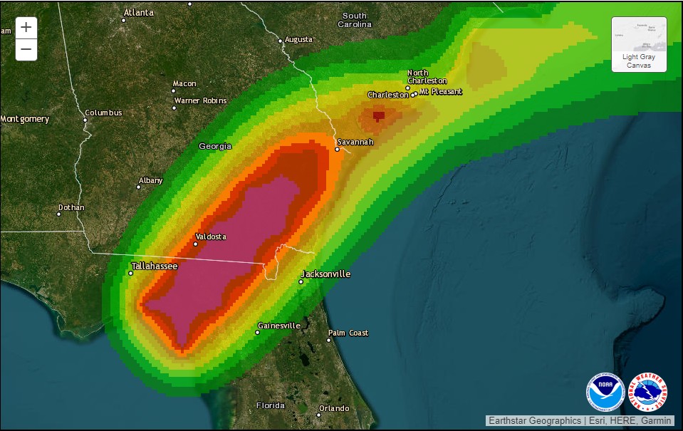
The other area of concern, in terms of surge, is along the coast of South Carolina, particularly near Charleston. Moderate to major flooding is expected in coastal South Carolina later this afternoon when Idalia’s storm surge combines with high tide.
Damaging winds
Idalia briefly reached Category 4 status this morning, but started weakening just before landfall early on Wednesday. This weakening was due to the storm undergoing an eyewall replacement cycle, a process by which an older eyewall weakens and a new one forms. After coming ashore, as storms typically do, this interaction with land has rapidly reduced Idalia’s maximum sustained winds. As of 11 am ET, the National Hurricane Center says they have fallen to 90 mph.
This is still strong enough to uproot trees and down power lines, however. This will be a significant problem in northern Florida, and southern Georgia and South Carolina. Idalia is expected to weaken to just below hurricane strength before moving into the Atlantic Ocean on Thursday morning.
Inland rainfall
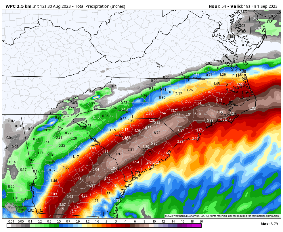
Despite Idalia’s relatively rapid forward movement, it is still expected to produce a significant amount of rainfall along its track across the Southeastern United States, including North and South Carolina. Some areas may see as much as 6 to 10 inches of rainfall in total, and a major concern is rainfall rates.
Tropical storms can produce some of the most explosive rainfall rates, which quickly back up drainage systems. Already, this morning, there have been reports of 5 inch-per-hour rainfall rates in Southern Georgia, which will cause significant inland flooding.
A rare location for such a storm
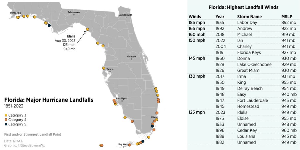
Meteorologist Steve Bowen has plotted the 21 known hurricanes, since 1851, to strike the Florida peninsula. Many of these storms were clustered in Southern Florida, with only a small handful in the Big Bend region of Florida. The strongest of these, Hurricane Michael, made landfall in 2018 with 160 mph winds.
Our next update will be today by around 5 pm Eastern.
Have y’all heard anything about it turning after it gets out in the Atlantic and coming back towards Florida?
That will probably not happen.
Tampa skates yet again. Good for them!!!
Hey Eric!
I followed Space City Weather up until I left Houston about 6 years ago to move to the Blue Ridge Mountains, right after that jerk Harvey smacked into us. (Remember that guy???) I remember when you first brought Matt on board. I remember the post you wrote when you knew you had to tell us just what misery and destruction Harvey was going to bring.
Now I’ve found myself living on the coast again, this time in Myrtle Beach in a place less than a mile from the shore. Been here less than 3 months and already a hurricane. Geez.
Even though this isn’t Houston, I went to Space City Weather. There I learned about The Eye Wall. I can’t tell you how happy and relieved I am to see that you and Matt have a dedicated hurricane site. This is awesome.
Thanks so much for all that you do.
Thank you for the kind words!!
Hey Eric,
Minor correction suggested. You referenced 21 hurricanes have hit Florida but based on the chart, I think you might mean 21 major hurricanes.