One-sentence summary
Tropical Storm Calvin will bring impacts to Hawaii later today and tomorrow, while Don stirs in a slowly awakening Atlantic.
Happening now: Hawaii readying for impacts from Tropical Storm Calvin
This is typically going to be an Atlantic-focused tropical blog, but truth be told, when something interesting or notable is happening elsewhere, it behooves us to offer some insights. Enter: Calvin. We discussed Calvin yesterday, and today we will watch for a close pass near the Big Island of Hawaii.
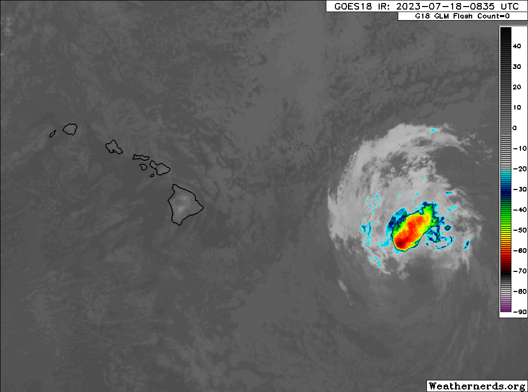
A Tropical Storm Warning was issued yesterday for the Big Island. From the satellite image above, you can see that Calvin is not greatly organized but it clearly has a lot of moisture as indicated by the bright colors on satellite. Right now, maximum winds are 45 mph, making Calvin a minimal tropical storm. But the combination of a weakening tropical storm, high pressure to the north, and some terrain will likely lead to a healthy wind event over many of the Hawaiian Islands, even those not under TS Warnings.
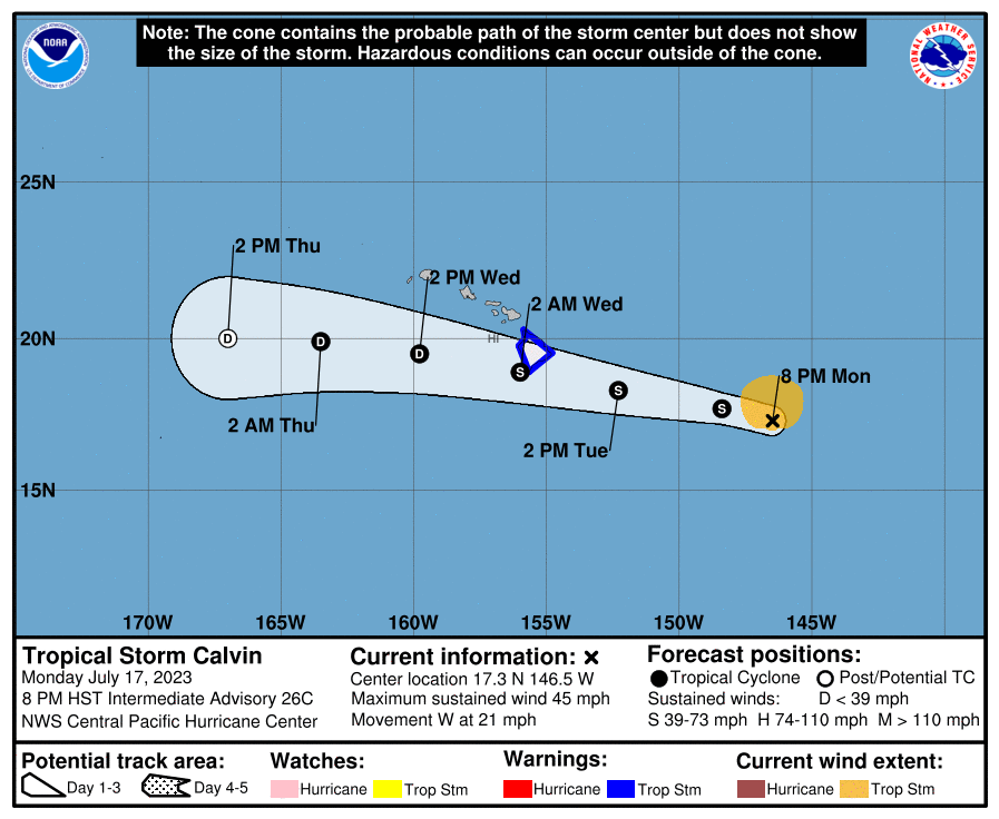
As the storm approaches Hawaii today, we’ll see rain pick up this evening (island time). Rain will be heavy at times on Tuesday night and Wednesday morning before slowly winding down Wednesday afternoon and evening. This will be a quick storm. For most populous locations, it will be a bit breezy with periods of rain. The heaviest rain and strongest winds will impact the Big Island and Maui. Wind gusts on Mauna Loa and Mauna Kea, as well as around Haleakalā on Maui are expected to be 50 to 65 mph, while at Hilo winds should gust to 40 mph. The Kona side of the Big Island will gust to about 30 mph. Elsewhere, we will see winds of wind advisory or high wind warning criteria in Maui County, as well as perhaps even in Oahu.
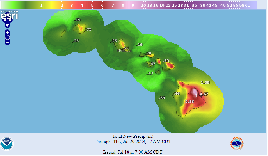
Rain totals are expected to peak in the 4 to 8 inch range on the windward slopes of the Big Island and the North Shore and eastern portions of Maui, with lesser amounts on the other islands. Hilo will probably see 4 to 6 inches of rain, while the Kona side of the Big Island will see 1 to 2 inches or a bit less. Flooding is likely in spots, particularly on east and southeast facing slopes, and a Flood Watch is posted for Maui, Molokai, Lanai, Kahoolawe, and the Big Island. Conditions will calm some on Thursday and beyond.
Shifting back to the Atlantic, Subtropical Depression Don reformed into a Tropical Storm on Monday evening. It continues to meander in the open waters between Bermuda and the Azores, with maximum winds of 40 mph.
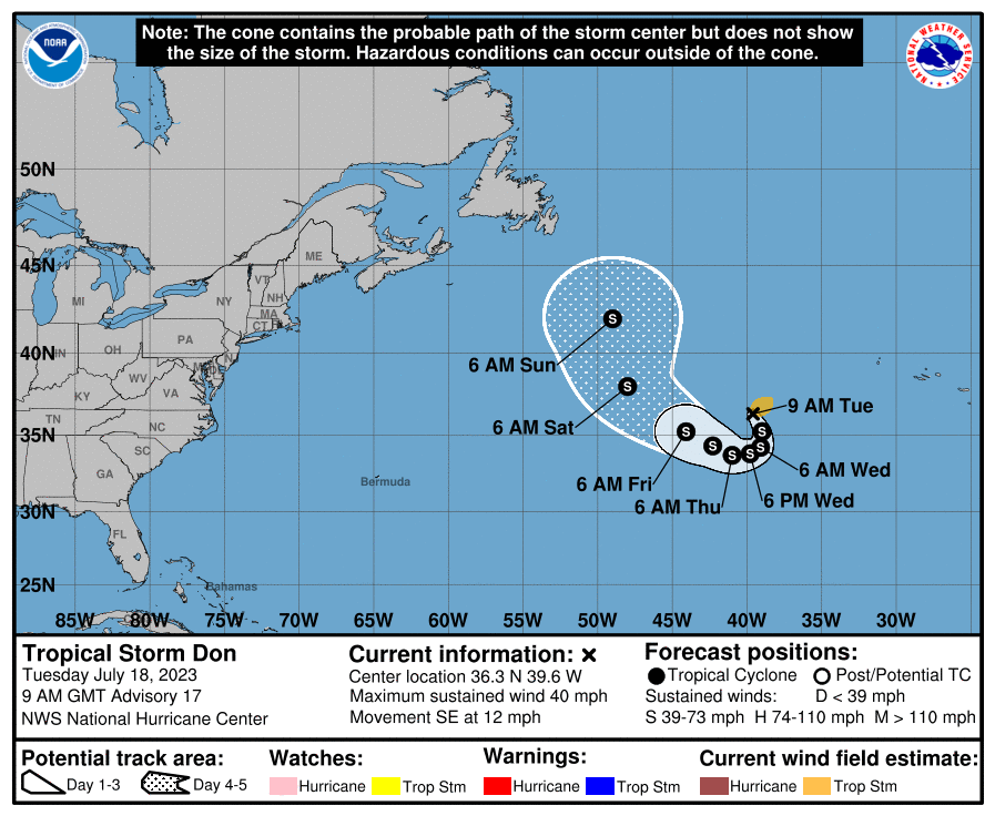
It remains no threat to land.
The medium range (days 6 to 10): Keeping an eye on the Main Development Region
Yesterday, we discussed the potential for a tropical wave emerging off Africa to maybe, possibly develop as it came west over the next week or so. There remains a bit of model support for this outcome, albeit not a ton. One thing that this or any wave right now will have to manage is Saharan dust.
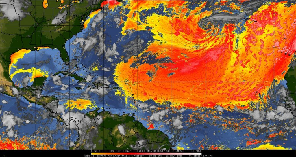
I believe this is our biggest dust outbreak of the season, and it will really hamper things a bit. So while I believe we should continue watching the MDR, and this wave near Africa in particular, it seems that this will be a bit of an uphill battle, especially over the next week or so. Also of note, this Saharan dust is going to overspread the islands in the Caribbean the next few days, arriving in South Florida by late tomorrow or Thursday and lingering into next week, as dust also works toward the U.S. Gulf Coast and Mexico.
Fantasyland (beyond day 10): Some stirring but no substance
We continue to see things stirring in the extended range, but there are no specific storms to hang our hat on in the modeling, with the exception of the wave mentioned above. That could perhaps be an issue if it develops for the day 10 or later period. But that’s really the only game in town right now, or at least the only one we can coherently point to at this time.
Love the posts! What is the relationship between Saharan dust and tropical system development? I’ve seen in a few posts that the dust can hamper systems but it would be great to better understand how that works.
Hey Josh: Saharan dust is usually a sign of dry air (it comes from the Sahara Desert after all!), so tropical systems do not care for dry air. Basically, it won’t necessarily prevent a system from developing, but it can act to limit a system’s potency. This is partially why June and July tend to be less active months; they are also peak months for Saharan dust, which declines in August and September. The dust also does a lot of other things globally from an ecology perspective…it’s actually kind of cool to play with a search on what this sand/dust does to soil, etc. around the world.
A worrisome aspect of the hot tub that is the Gulf of Mexico this year is even if we do not have a bona fide hurricane landfall, a tropical storm or just a nice upper level disturbance can draw on the 85+ degree waters and set up some serious training rainbands.
Can anyone say 4″ an hour rainfall rates?
Between more available moisture and more available “rocket fuel,” correct, this is not a great setup. Hopefully we can skate through the season with limited issues, but hope is not a strategy, of course.