One-sentence summary
We are all clear for the foreseeable future in the Atlantic!
Happening now: The Atlantic is sheared and the Gulf is rather dry
A one-two punch of factors in addition to climatology is inhibiting tropical development across the Atlantic basin at the moment. Across most of the ocean, you have wind shear. That is also present in the Caribbean today. Wind shear acts to minimize tropical system organization in most cases.
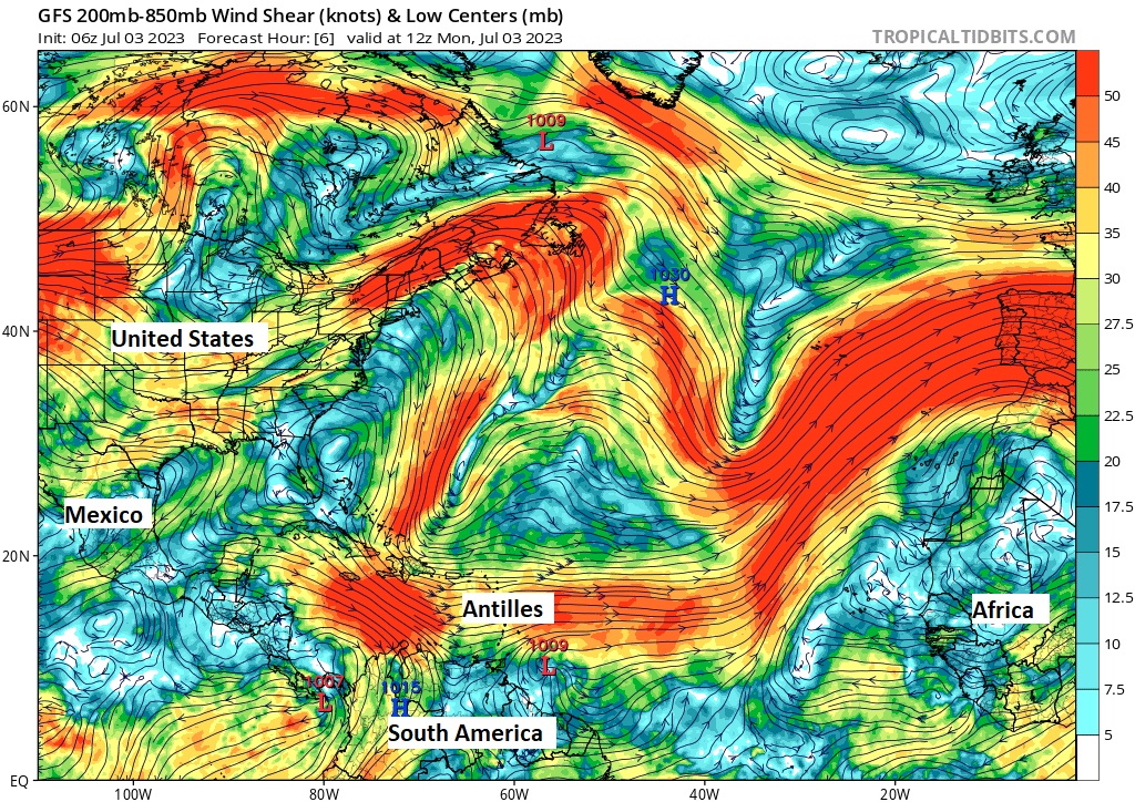
The Gulf? Not a ton of shear! However, the Gulf is loaded up with dry air right now, so any development would be hindered substantially by that. There will be moisture reloading into the Gulf this week, but nothing organized should come from that occurring.
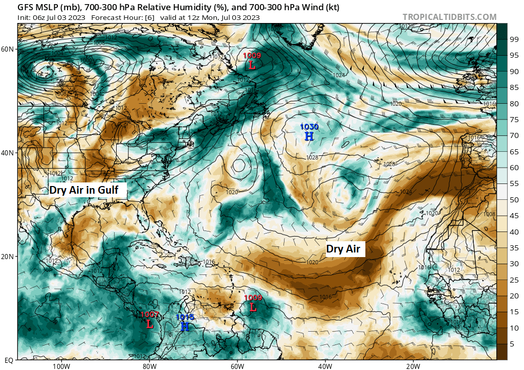
These factors are helping to keep any chance at activity in the Atlantic virtually non-existent this week.
The medium-range (days 6 to 10): Shear and dry air continue
The combination of wind shear and dry air will continue to likely impede any development in the Gulf, Caribbean, or Atlantic through day 10. The Pacific will likely continue to stay a bit busy.
Fantasyland (beyond day 10): Slumber party?
We continue to slumber in the Atlantic. The GFS operational model, the 4-times daily deterministic guidance that often produces false alarm storms can’t even really latch on to much of anything out into fantasyland, so we’ll continue expecting a quiet outlook for now. I would not be entirely shocked to see something lower-end or close to home try to form in this period, but really, that’s me going on gut and some high-level model data. But it would seem we may be shaping up for a fairly quiet July.
July climatology & June review
Through the end of June, we have amassed a total of 9.8 Accumulated Cyclone Energy (ACE) units. ACE is a way to gauge individual storm or season intensity. Units are accumulated by summing how long a storm stays at a particular intensity. We can tally those up by storm or by season to get a number to compare to past storms or seasons. Unfortunately, ACE is not perfect, as you are merely looking at wind speed and duration of wind speed. Hurricanes and tropical storms are more complex than that alone. However, it counts for something.
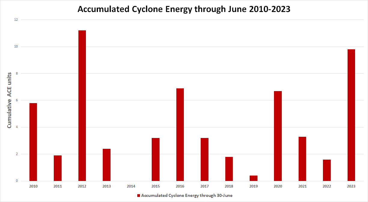
9.8 units of ACE is actually pretty impressive through the end of June. We should be at about 2.5 units. However, that said, an average season has something on the order of 122 ACE units, which argues that we have about 97 to 98 percent of hurricane season still ahead of us from an intensity perspective. Junes are variable and never usually too crazy, and they don’t mean much in terms of what may be coming the rest of the season. June of 1934 was a particularly big month with 19.5 ACE units from one slow moving hurricane off Central America. That hurricane season ended up near average. 1886 was another pretty wild June with 20.6 ACE units when 3 hurricanes developed, one of them hitting Texas and the other two hitting Florida. That season was active. So again, don’t read into these numbers too much.
So what of July? Well, as you read above, we currently expect a mostly quiet month. We will see how that holds up. But, historically, July is often a quieter month in terms of landfall risks.
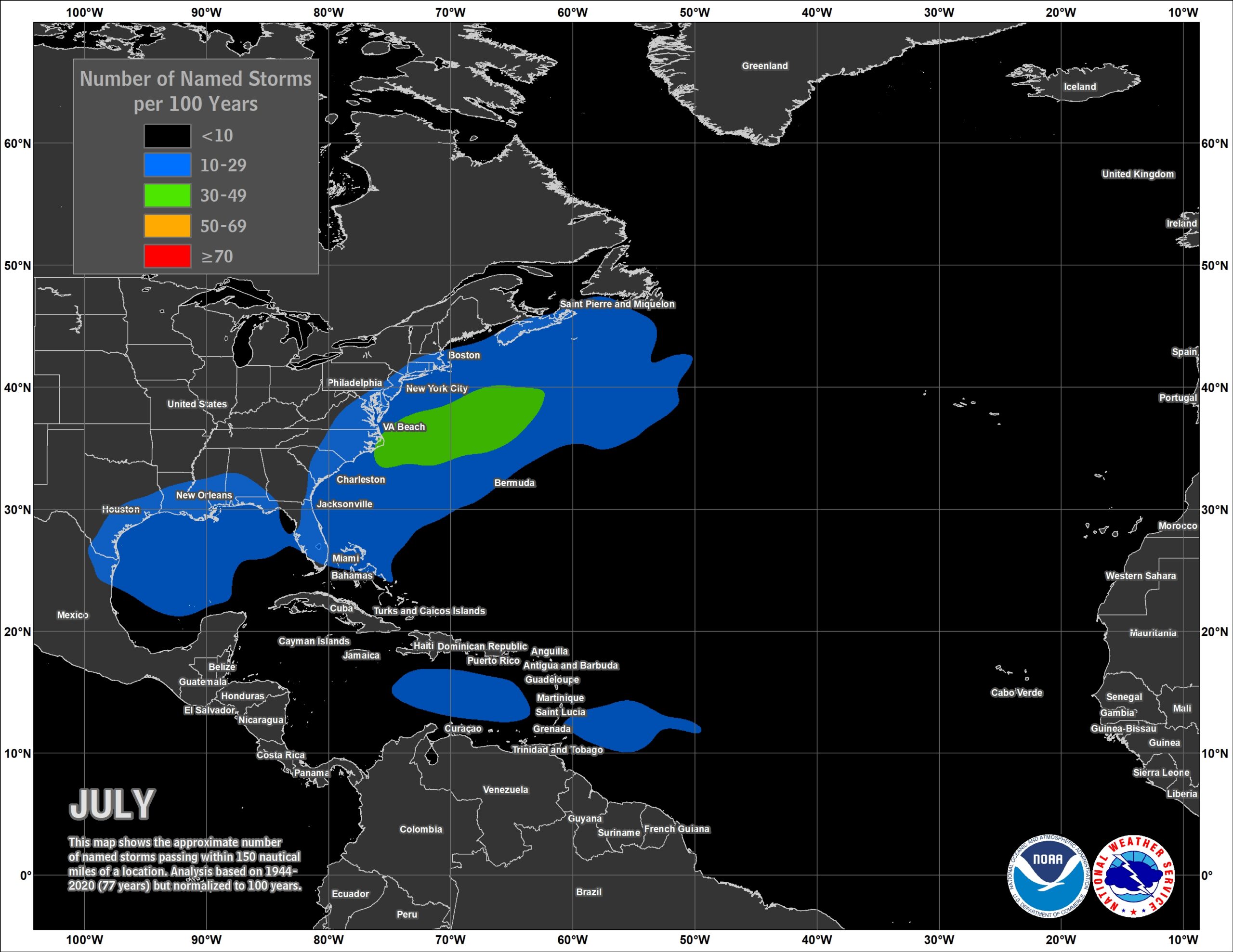
July is actually a bit quieter on net in parts of the Gulf of Mexico relative to June. There tends to be a little more action in the Caribbean and near the Lesser Antilles. But the main area of activity appears to be off the Mid-Atlantic coast, with storms that tend to form near the Carolinas and shoot out to sea. So if you want to know where you should be watching, there you go. It’s not really until August that things get going, and the second half of August at that. So, we still have some time. It’s as good a time as any to review your personal situation and prepare in case things do get active.
We will take tomorrow off in observance of Independence Day in the U.S., and we’ll be back with you on Wednesday morning!
Thank you for the info and for explaining everything so clearly. Our hurricane season is not nearly so scary with you guys in our life. 😊
Exactly what she said ☺️
🌬⚘⚘⚘
Thank you!
Happy 4th of July Matt.
Happy 4th of July💥!