One-sentence summary
A pair of tropical systems have a chance to develop in the Atlantic, but both will scoot out to sea and not be a direct impact land.
Happening now: Invests 96L and 97L
As expected, the tropical wave in the middle of the Atlantic Ocean is on its way to potentially developing later today or tomorrow. This wave is now tagged Invest 96L. Meanwhile, off the North Carolina coast, we have Invest 97L, which is a vigorous area of thunderstorms with a lesser chance of developing in the next day or so.
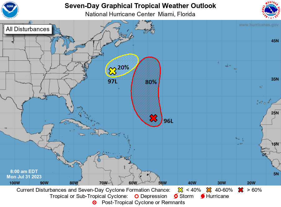
Regardless of development, both systems will move out to sea, and neither is a threat to land. Even Bermuda should see only fringe effects at worst.
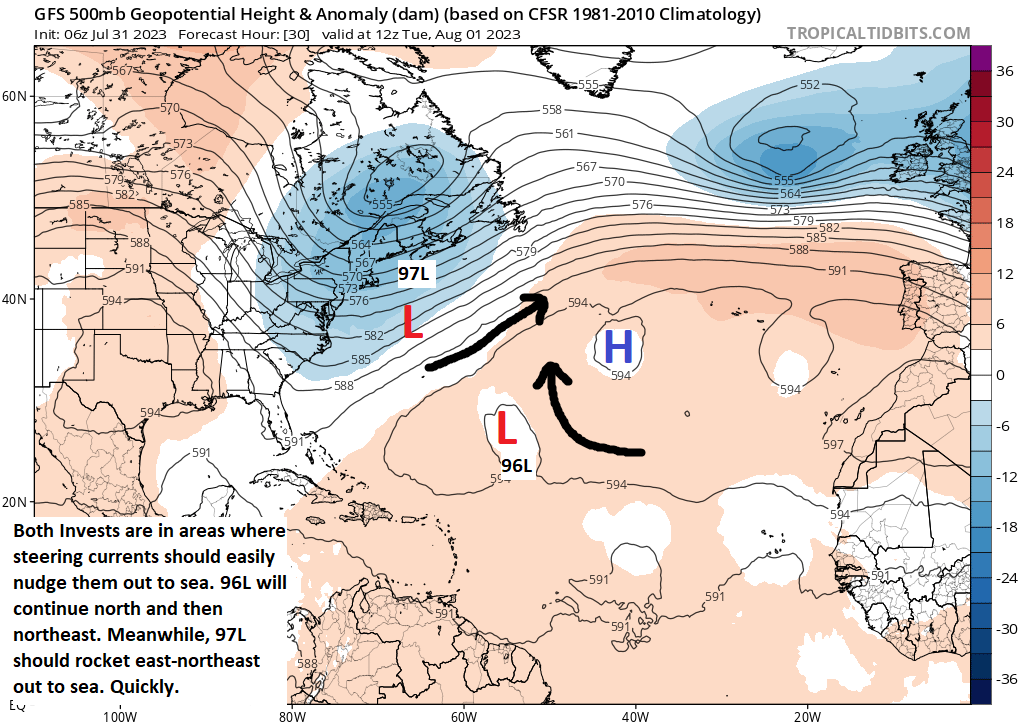
Why are we confident that both systems will turn out to sea? A quick look at the upper levels of the atmosphere shows that both systems have a pretty easy exit path away from land.
Invest 96L
The area we’ve been watching since last week out over the open Atlantic took on the Invest 96L tag over the weekend, meaning it became an area to investigate and we got some additional model data on it to look at. This really just confirmed what we already had confidence in, that this system was likely heading out to sea.
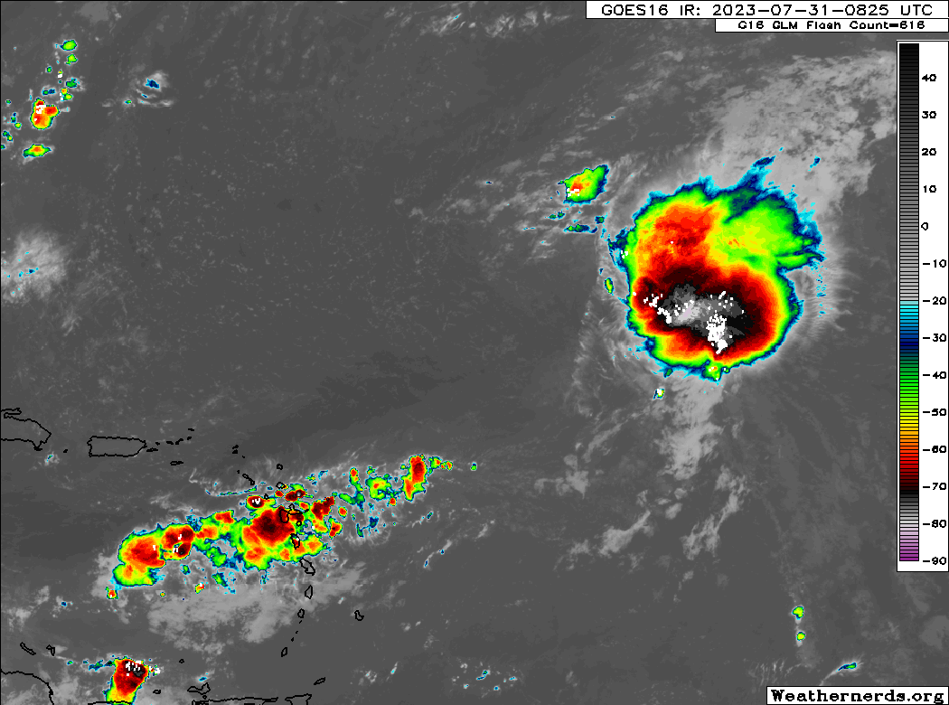
On satellite this morning, 96L doesn’t exactly look exciting, though I’ve seen worse looking storms upgraded, so we’ll see what the NHC finds in the next day or two. The 80% probability from the NHC seems perfectly fine here, because there’s a good chance it will develop, but it’s definitely not a guarantee. The ceiling on this system looks like lower-end tropical storm so not a huge deal. It will struggle due to wind shear and sinking air. It has about 3 or 4 days before it’s outta here.
Invest 97L
Admittedly, it’s 97L that looks most interesting this morning.
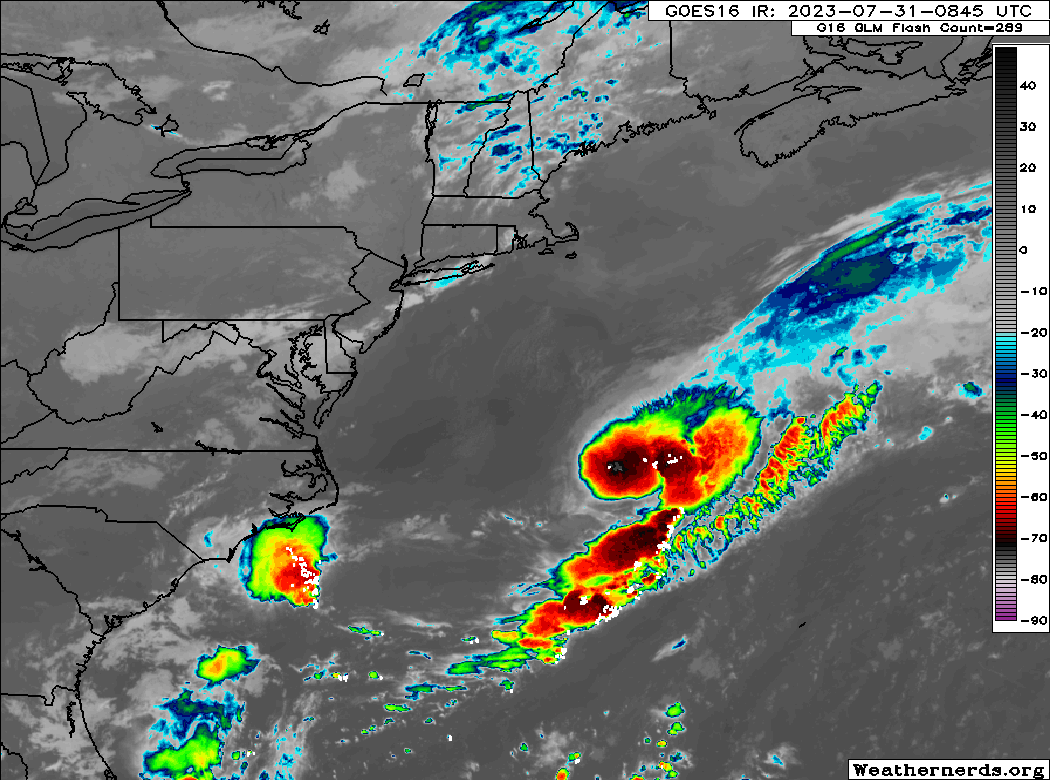
There’s a hint of spin to it as it moves northeast, but this is more like a nor’easter than a tropical system in terms of how it’s developing (the formation process is being driven more by fronts and atmospheric dynamics than warm waters and heat). While that’s primarily a technicality, it’s all moot as this is heading out to sea. This could graze Bermuda with some thunderstorms as its trailing cool front approaches and stalls near the island. Aside from that? Not much to this.
The medium range (days 6 to 10): Pressing reset
A period of calm is expected to take control of most of the Atlantic basin this weekend and early next week, and we do not expect any storm activity as the atmosphere sort of presses the “reset” button. For the most part, this calm is expected to last into…
Fantasyland (beyond day 10): Still calm? Perhaps.
We don’t see anything of note right now on any modeling that indicates things will pick up at the end of the 10 to 14 day period. Last week, we were hinting at a potential ramp in activity for mid-August. Some of the support for a more conducive background state seems to have faded some, as the Pacific side heats up. There would be two primary ways to generate activity should that be the case, since an active Pacific generally means a quieter Atlantic. First, you’d have to watch close in for something, say, in the Gulf or just off the coast. Second, with a good bit of storminess ongoing in Africa, that could potentially get something to flare up in the far eastern Atlantic in time. But we have plenty of time to watch.
Early August and everything after
Which brings me to what I wanted to touch on more today. Where do storms usually form in the first third of August?
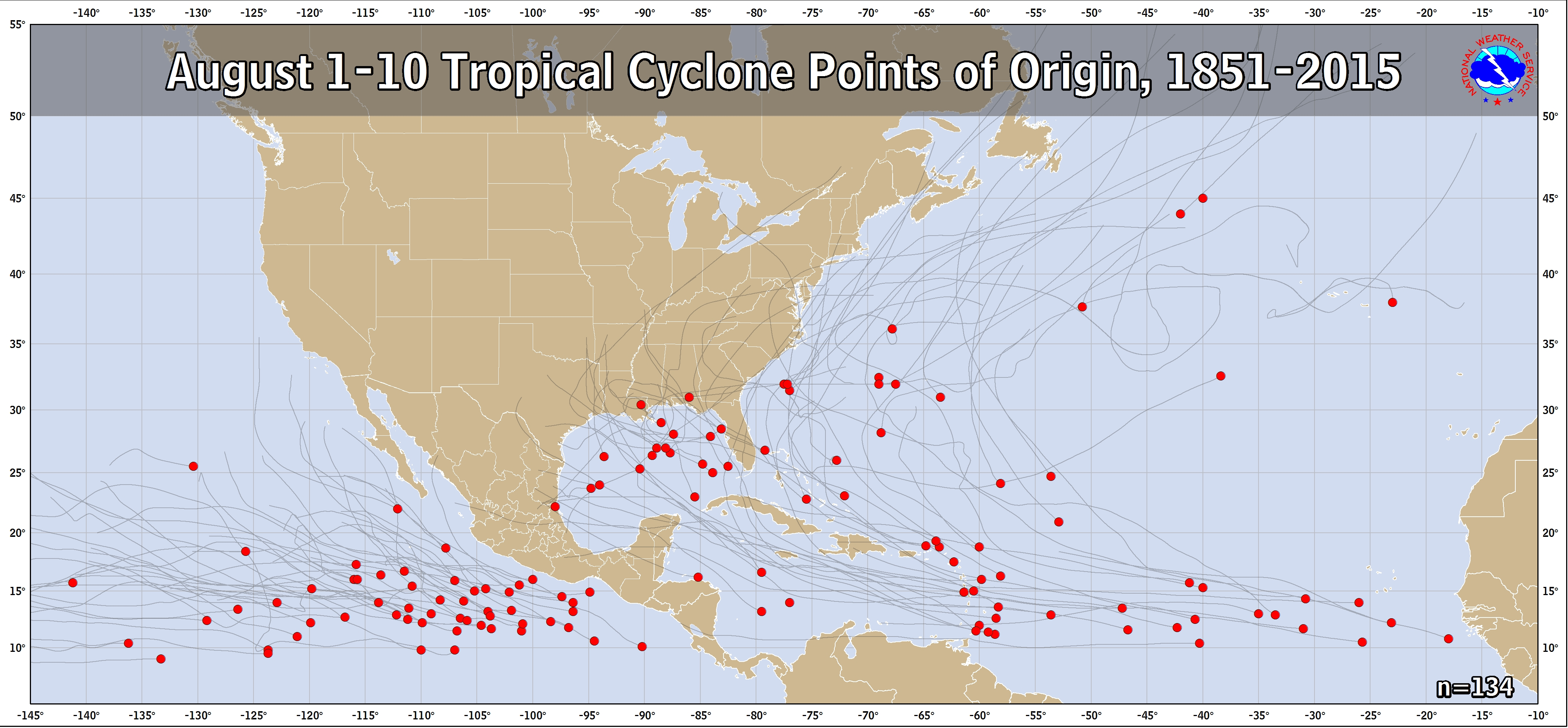
The Gulf is a hotspot in early August, with numerous storms historically forming there. We also tend to see flare ups near the Lesser Antilles, as well as a peppering of storm origins across the Atlantic. So where do you look in early August? The Gulf, the Leeward & Windward Islands, and across the Atlantic.
We are entering the ramp up of hurricane season. Accumulated cyclone energy (ACE) for the season to date is quite high, thanks mostly to Hurricane Don. We’re over 16 units of ACE right now for 2023, which is almost twice as much as normal for the end of July. Remember, ACE is a stat that factors in the wind speed of tropical systems and for how long they maintain that intensity, and we sum it over the season (hence: accumulated). Far from perfect, but it gives you a sense of where the season compares to prior seasons in terms of activity.
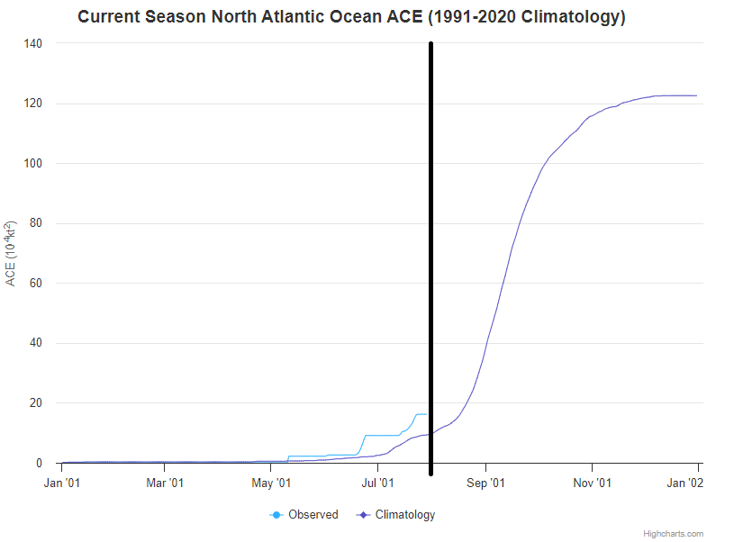
But, it’s important to note that we still have about 92 percent of hurricane season from an ACE standpoint still in front of us. It remains early. That said, by the end of August, we jump from today’s 8 percent of the season climatologically complete to 30 percent. We ramp things up in a big way after the first third of August. So, the fact that it’s looking fairly calm to start August is great news, but we’ve got a long way to go. Fingers crossed!
ACE evaluations during La Niña cycles, is there much data on that?
ACE is usually higher during La Niña events and lower during El Niño events, such as the one we’re currently experiencing.
That’s very interesting how if the Pacific revs up, the Atlantic tends to quiet down; like a see-saw effect between the two? Almost like an energetic transference.
Where can I go to learn more about that/does it have a name? Does it happen between other large bodies of water as well?
Cool stuff 🌊
There’s no name, but if you do some googling for Madden-Julian Oscillation (MJO) and hurricanes or Kelvin waves and hurricanes, you can occasionally find explanations as to what causes the Atlantic to become more active. In general, if the Pacific is active, a lot of what we call the “forcing,” rising air that helps support and nurture thunderstorms is co-located over there. Similar to the idea of “what goes up must come down,” downstream from there, in the Atlantic, there would be more sinking air or less supportive conditions that help keep tropical activity more in check. It doesn’t always work perfectly, but at scale it sometimes can work well.
The Atlantic as downstream makes a lot sense 😊
Ty 🌬⚘
*of sense
☺️
Looks like El Nino is taking effect?
Certainly not hurting!