One-sentence summary
Bret’s center has cleared the islands, but heavy rain remains behind it, as Tropical Storm Cindy scurries about over the open Atlantic.
Happening now: Bret about to enter the Caribbean graveyard, Cindy doing its own thing
Tropical Storm Bret
Bret is not the first storm, nor will it be the last storm to enter the eastern Caribbean and be devoured by wind shear. We call this part of the Atlantic a hurricane graveyard. And that’s actually rooted in science. Many storms enter this part of the basin and fizzle out. It has to do with a low level jet (strong winds about 5,000 feet up) and wind shear that is particularly enhanced during El Niño summers such as this one. Bret is feeling that now, and the feeling will grow in the coming days.
Bret has a lot of storms associated with it, but it looks very disheveled at the moment.
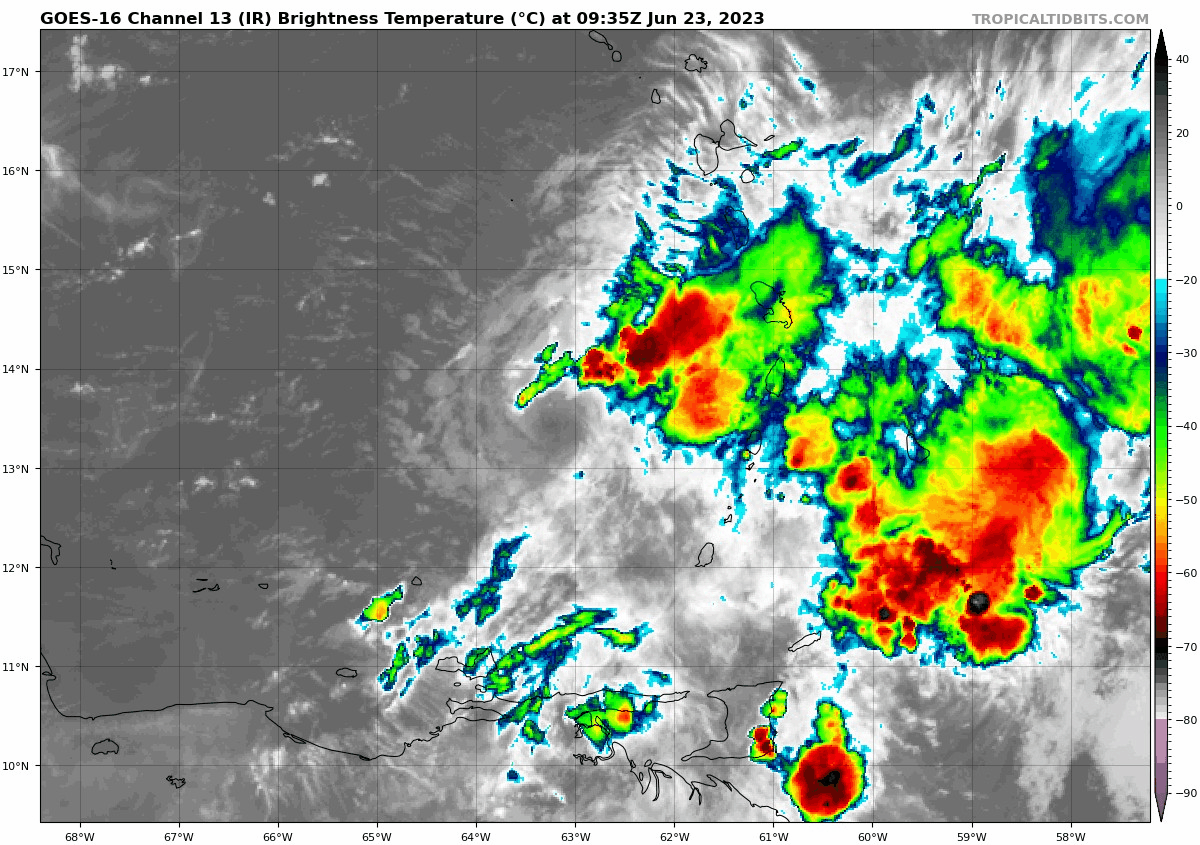
But, just looking at that satellite loop above, you aren’t thinking 60 mph tropical storm. For all intents and purpose, Bret will be lucky to survive into tomorrow.
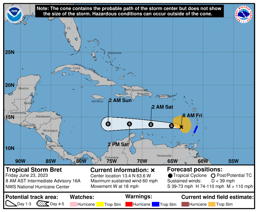
Bret will continue due west until it degenerates into an open tropical wave sometime before it gets south of Jamaica.
Impacts from Bret will be in the form of rainfall and choppy seas, neither of which look especially serious at this time. Another 1 to 3 inches of rain are possible from Dominica south through St. Vincent and the Grenadines or Grenada. Some downpours may even clip Bonaire, Curacao, or Aruba on the way out, but nothing serious is expected there.
Otherwise, we can say bye to Bret.
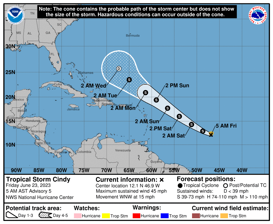
Tropical Storm Cindy
To the east of the islands, Tropical Depression 4 developed into Tropical Storm Cindy late last night, our third named storm and fourth overall of 2023. Thankfully, Cindy is not a threat to land, and it will experience a relatively quick demise in the days ahead.
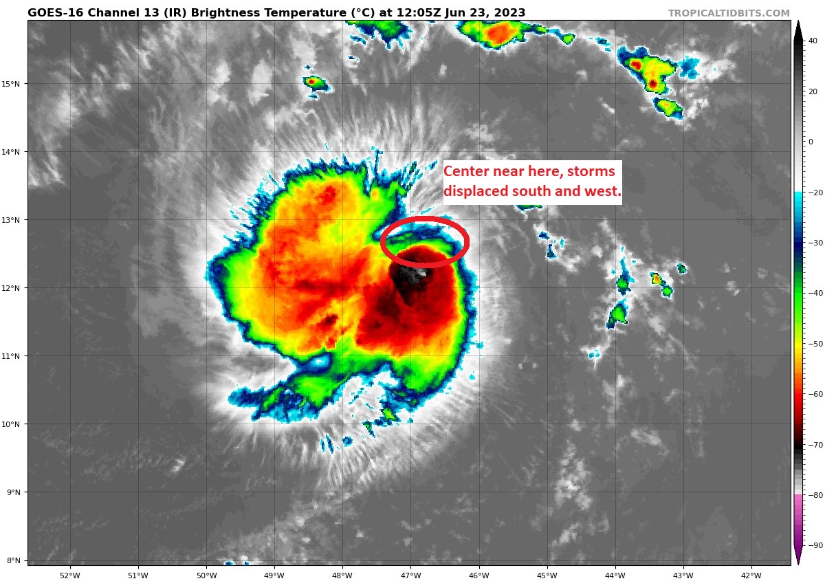
Cindy looks like a blob this morning, clearly fighting wind shear. The thunderstorms are displaced to the south and west of the center.
Over the next couple days, Cindy will gradually turn northwest, likely struggling a bit the whole way. Shear and dry air will take a toll, and Cindy will degenerate into an open wave next week, north and east of the islands. It is no threat to land at this time.
The medium-range (days 6-10): Quieting down
Cindy’s remnants will turn northward and probably remain disorganized in some capacity possibly near Bermuda at some point. But it could bring a bout of unsettled weather to the island. That third tropical wave behind Cindy is unlikely to develop. Elsewhere, there’s nothing to speak of, and we should enter July on a quiet note.
Fantasyland (beyond day 10): Nothing expected
At this time, nothing is expected to cause issues through July 10th or so. I do think we’ll begin to see moisture return to the western Gulf as high pressure that’s been baking Texas and Mexico begins to shift away. But from this distance at least, it does not appear anything will develop.
Incredible how winds near a mile up can affect a storm. Here’s hoping E. Texas can get a little relief from the heat as a result of the remnants of this storm. Really like this daily format. Keep up the informative info.
Thanks!
Have you ever thought about writing a Hurricane 101 article and maybe pinning it in the webpage somewhere? You could go over what makes a hurricane, the different ways a hurricane forms, the different kinds of impacts on a hurricane, the different categories, the different speeds, the different impacts from TD, TS and hurricanes. What determines the season, etc., etc. That would be a lot of writing, but if you work on it a little each day, you might have it finished before next season.
Long-term goals for sure. There are a few for this site. None are easy, but we’ll get there eventually I hope. Appreciate the suggestion!
I’m glad Bret will be shredded in the carribbean! But can you confirm it’s not forecast to cross into the gulf of Mexico and possibly regenerate?
Yes, I can confirm.