Good morning. Welcome to the first full week of The Eyewall, now a true tropical site since we had our first storm. A quick reminder, you can subscribe to our daily emails or reach our social media sites at the right on a desktop. If you’re on your phone, scroll down to the bottom of the page, and you’ll see the sign up form, as well as links to our social media sites just above the bottom. Facebook, Twitter, and the Gram are fully functional now. Still some work to do with TikTok. We’ll get there.
We’ll start this week by tying a closure ribbon around Arlene. It’s somewhat instructive to just look at how much rain has fallen over Florida for the last week.
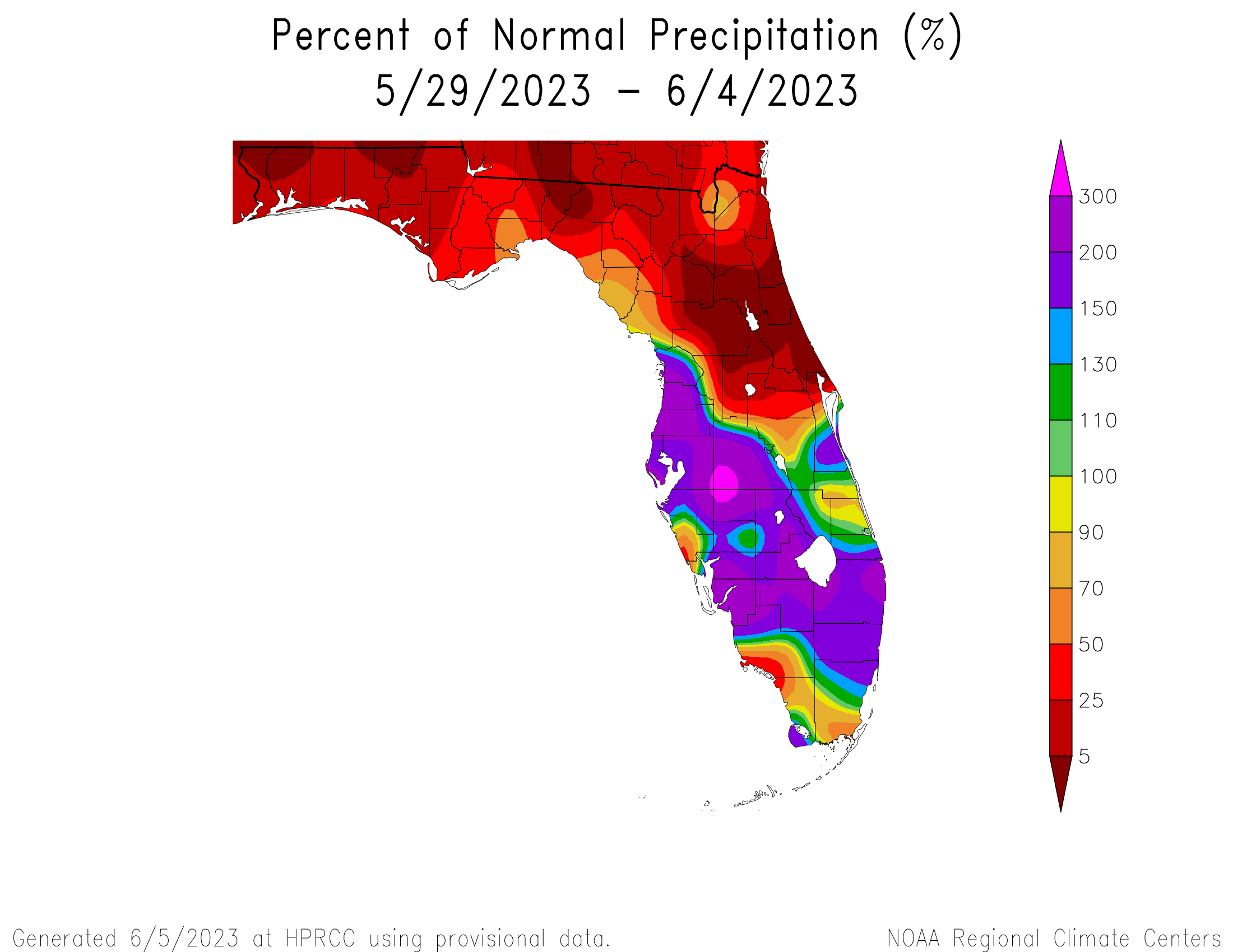
A nice reminder for hurricane season that impacts from storms are not always straightforward. While there has not been any real widespread flooding in Florida, there have been a few wild storms and certainly some localized flooding over the last week tangentially associated with Arlene. The highest June 1 through June 4 rain total I found in Florida as of yesterday morning’s CoCoRaHS reports was just shy of 8 inches of rain near Parrish, FL, which is just southeast of the Tampa Bay area in Manatee County. It should hopefully be a bit of a calmer week across Florida this week.
One-sentence summary
The tropics look fairly inactive over the course of this week, with little to watch.
Happening now: Not much
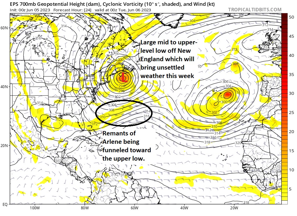
It’s quiet out there. Whatever is left of Arlene is getting funneled east and north toward a rather beastly upper level low that’s expected to pester coastal New England and Atlantic Canada through the week with rain chances and cooler than average temperatures. This is not a tropical feature, but it’s nonetheless interesting.
The National Hurricane Center has also tagged an area way, way out in the Atlantic south of the Azores for a 10 percent chance of development. That would be bizarre, but as of now it’s not a high probability risk. Aside from that, there’s nothing out there that’s a candidate for development this week.
The medium range (days 6-10): Still expected quiet
Not a lot to speak of for the next forecast period from the weekend into next week. The New England upper level storm exits, and another may try to follow suit for the Mid-Atlantic. The basin itself looks pretty quiet, which begs the question: Where should we be looking for development in June anyway?
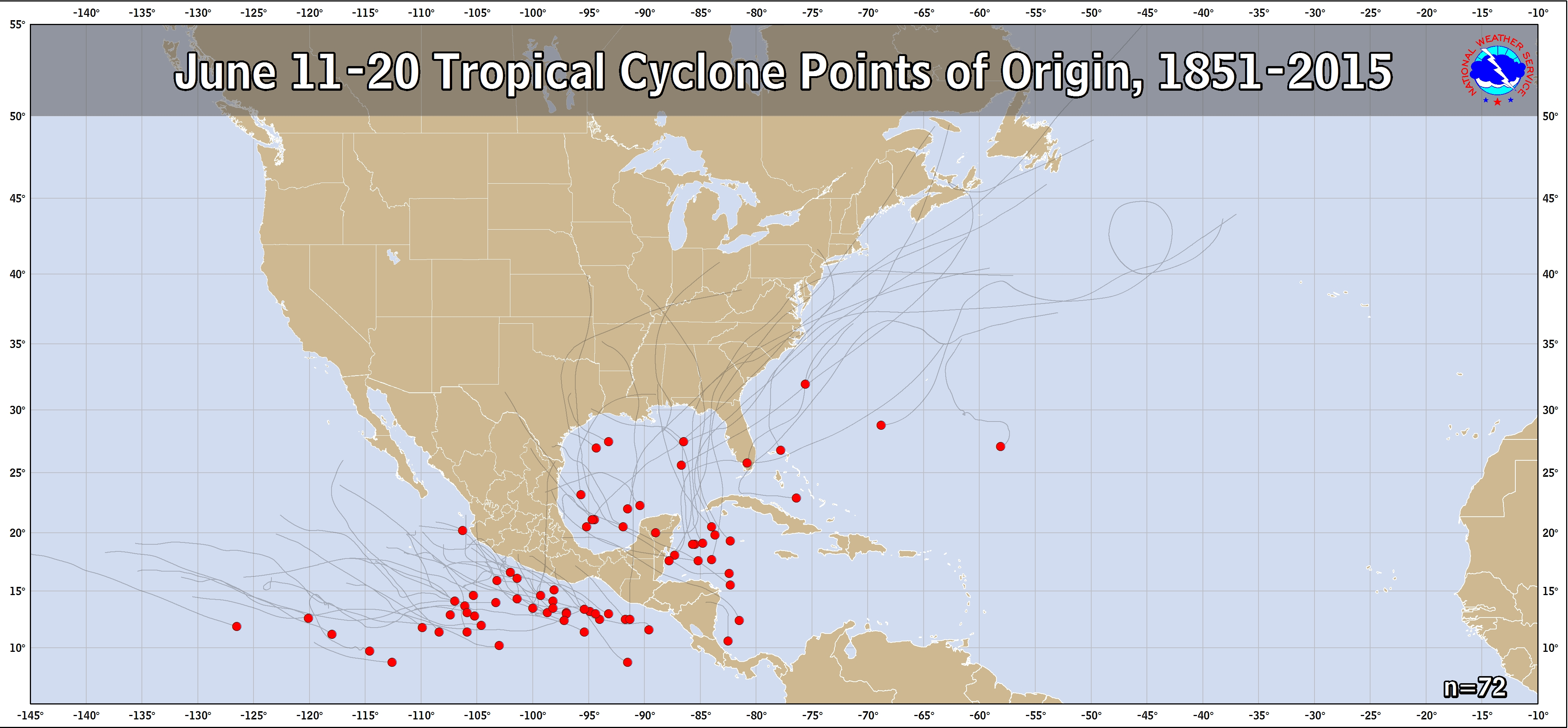
When we think about early to mid June, we think about two areas mostly: The Gulf and the northwest Caribbean. Though the map above cuts off in 2015, you get a pretty good idea of what history favors. In that sense, Arlene was not exactly abnormal. By far, the highest density of development in mid-June, however is the northwest Caribbean. So if you want to look for something, look there. Which brings us to…
Fantasyland (beyond day 10): Maybe watching the northwest Caribbean
So, if you are an avid model watcher, you may have noticed the last few runs of the GFS operational model picking up on what I derisively refer to as a “scareicane” on days 14-16 of the model run. The reason I call it that is because the GFS model in particular is notorious for taking relatively minor disturbances on day 10+ and inconsistently blowing them up into scary looking Gulf or Caribbean storms. In other words, if it looks crazy on day 15 or 16, it probably is.
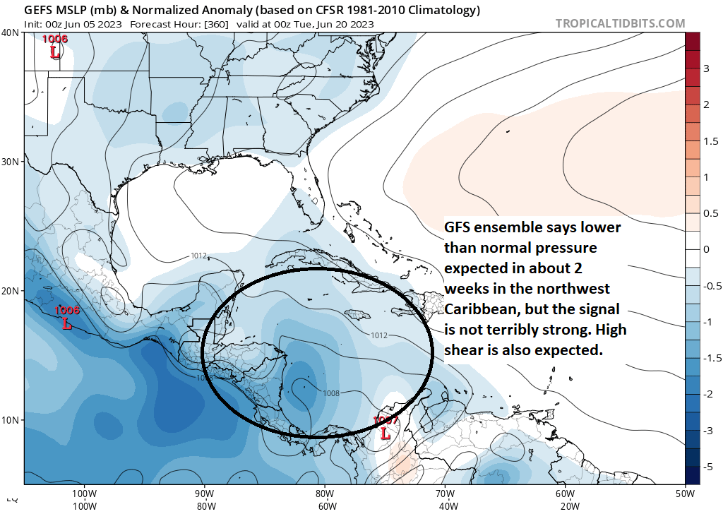
That said, if you dig a bit deeper, there is some reason to at least pencil in the June 20th (or later) period as one to perhaps watch for our next development window. As you can see above, there is support for lower than average surface pressure in the northwest Caribbean in about 2 weeks, but nothing that exactly stands out. However, we’re going to have a pattern more favorable for rising air, an ingredient tropical systems like, begin to move toward the eastern Pacific and perhaps far western Caribbean, or so it seems, around that time. Usually, when I see these signals in the modeling, it means that there may be something to come, but the GFS operational model is probably a solid 7 to 10 days too quick showing it out there. Judging by the potential for some of these better ingredients lagging the end of the run by a few days, that makes sense here. So that pushes us out closer to June 25th, give or take. A somewhat better signal appears to show up in the Pacific, so we’ll probably see something attempt development there before our next chance on the Atlantic side. That said, wind shear looks to remain quite strong, so as of now, all of this falls very much under “curiosity” more than concern.
In sum: Conditions may begin to get a bit more favorable for some sort of tropical system by late June, but it’s best to ignore any operational models showing rogue day 14+ hurricanes right now, as that is a very unlikely outcome. We’ll be back with more tomorrow.
In the meantime, please feel free to comment or drop us a feedback form to tell us what you like or dislike about these daily outlooks. You can expect this sort of update each weekday morning through October or November, with more frequent updates when there are storms threatening land. Feedback is always valued, but especially so right now as a new site. Thanks for your early support!
Now that we live in Florida, I am so glad to still benefit from the wise and hype-free weather observations of Matt and Eric! Keep up the good work guys, we’re still counting on you.
Really enjoying your posts. Very straightforward and to the point. Keep up the good work.
Regards,
Former Floridan
I’m enjoying my hurricane education. Not too much goes over my head!😁
Is the Sargassum seaweed hitting the Florida coast indicative of a lack of activity? Appreciate the updates.
So there’s mixed news on that front: https://www.miamiherald.com/news/local/environment/climate-change/article275992461.html While the sargassum belt saw a reduction in size last month (which is odd), it generally tends to thrive in warmer oceans. So in reality a more hospitable environment for tropical storms actually also can aid in sargassum. If that makes sense. However, there is no direct relationship between the two.
Thank you for developing this new Eyewall site. It gives me the information I need in a concise, efficient manner. I love the fact that I don’t have to navigate through a bunch of useless junk to get to what is actually relevant. Wishing you great success with this!
Really appreciate the new dedicated storm season content and I’m sharing the site with all friends and family on the gulf coast.
I do wonder if every day is going to prove the best fit. I don’t want y’all to get burned out having to say “nothing new” every day until something interesting comes along.
Of course, if you feel that you’ve got the content for daily updates, even if it is getting into trends and history, I’m all for it.
Thank you! Hey, if it’s quiet and we don’t have much to say, we’ll say that. Most people just want to make sure nothing’s changed this time of year, and we’re good with keeping it short if we have to.
I am really liking what I see in the Eyewall! It has all of the information that I need in one concise and informative format that is easy to access and use. Thank You! for SCW and the Eyewall, as I thoroughly enjoy both.
The only recommendation I would make is maybe adding anchor links to jump down to specific sections. Otherwise, this is great content and very helpful!
Love SCAREACANE
I know!
Really like the quick summaries for folks!
Absolutely 💕love💕 the explanations: lucidity ☺️
Love the new site and if I didn’t know this was your site, I would know just by reading it. Keep up the great work! “Happening now – Not much”. Simple and direct.
What are your thoughts on the ECMWF (Euro) model predicting an above average year for hurricanes? Seems to think that the warmer than normal Atlantic and gulf temps will win out over the El Niño that should form, which typically has below average hurricane forecast, due to the high wind shear.
The question of questions. I’m actually going to address this to some extent tomorrow. In a nutshell: It’s complicated. The warmer than normal temps are reason for concern. But wind shear is tough to outdo in +ENSO years. That said, if there were a years where that has a possibility of happening, it may be this one. So it poses a difficult seasonal forecast.
Could it be a case where the season is far more active in some areas, like the mid-Atlantic, and far less active in other areas, like the Gulf and Caribbean?
This newsletter is great! Although I wouldn’t expect anything less as you guys do an amazing job dispersing the facts. I am so happy that at least one aspect of the news is not overly dramatized. Thanks for the no hype weather.
Fantastic job on this site as well as your Space City Weather site! You guys are a treat to read and we are very thankful for your sharing your weather wisdom with the rest of us. The quick summaries are my favorite spot thus far…until the first seriously severe weather system heads our way and then I’m going to be all over the details. Either way, y’all are generous in your willingness to perform this service for the rest of us. Keep up the great work!
I’m loving this new platform dedicated to hurricanes. Growing up in Houston metro and experiencing the stillness of the eye of Hurricane Alicia in 1983 along with numerous other storms I like to be fully informed without the fear factor/sensationalism. Thanks for also explaining the reasoning behind some of the models getting too aggressive with forecasting storms.
Great work. And if you’d like a sponsor let me know and I may be available to help sponsor the site with my small company.
I’ve been looking for something like this since Jeff Masters retired! I’m on the East Coast so I like to keep an eye on things, and there’s nothing better than an in-depth science discussion and the “no hype” approach. Good stuff!