Happy Tuesday to all. It’s very early in hurricane season, but at the very least, we’re trying to make sure you have a reason to check us out each day with something interesting. Today we’ll have the first of four parts on the seasonal forecasting challenge for this particular hurricane season. We’ll discuss the forecast today, El Niño tomorrow, water temperatures in the Atlantic on Thursday, and then the risks regarding the season on Friday.
One-sentence summary
No meaningful tropical development is expected over the next week or so, though a system near the Azores Islands has a very low chance to briefly become something before the weekend.
Happening now: Strange system swirls near Azores
The fact that we’re even discussing the Azores in June is pretty ridiculous. Storms simply do not form here this early in the season. There’s an argument to be made that maybe 40 or 50 years ago, in this same scenario, we actually would not be talking about the Azores because the technology to monitor these things has improved so much. So in 2023, we can tag disturbances and even name lower-end systems that would not have had that done “back in the day.”
Regardless, it’s impressive and looking at satellite this morning, it’s evident that we have a system out there, however when you go “under the hood,” this is technically not a tropical or subtropical system at this point.
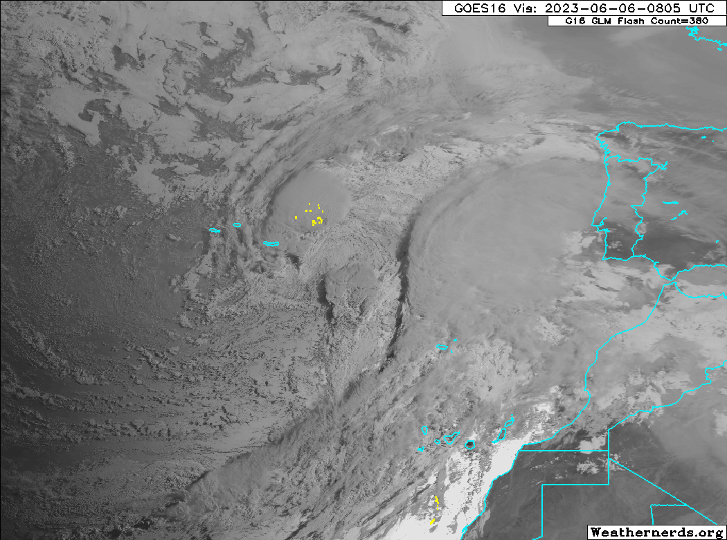
In a future post, we’ll get into the technicalities of these things; what is subtropical versus tropical versus extratropical or cold core versus warm core and why all these things matter meteorologically. The bottom line on this particular disturbance is that it has about 24 to 36 hour window to develop some warm core (tropical) characteristics, as it is moving over an area with sea surface temperatures that are anywhere from 2°F to 5°F above normal.
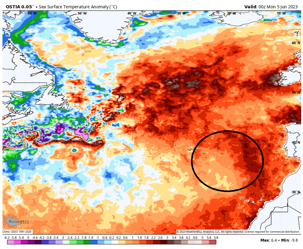
That said, the current 10 percent probability offered by the National Hurricane Center seems fair, as the water is still fairly cool for true tropical development here.
The medium range (days 6-10): Still quiet
There’s nothing new to add in this period today, so we’ll keep this simple. All’s quiet.
Fantasyland (beyond day 10): No changes in thinking
Yesterday’s post discussed why things may become more favorable for something later in the month. Nothing has changed today regarding that topic. The GFS operational model continues to spit out a somewhat spurious looking system around days 13-16. It continues to be mostly on its own bringing it northward toward the Gulf, lacking any real meaningful ensemble (multiple runs of the same model with tweaks) support for that at this time. We will get into the operational versus ensemble model differences sometime soon.
The 2023 seasonal outlook Part 1: The forecast
Alright, let’s talk the seasonal forecast. We will break this out into four parts over the coming days so as to not inundate you with too much stuff at once. Today, we’ll explore the forecasts. Tomorrow, we’ll discuss El Niño. On Thursday we’ll look at water temperatures across the Atlantic basin. We’ll wrap things up on Friday by putting this all together and discussing the risks.
The caveat I have to start with: Seasonal forecasts are mainly scientific research exercises. You should prepare each season as if it will be the one where a storm strikes. Below average seasons can be bad ones too. Last year was near average and produced Hurricane Ian. 1992? A pretty quiet season, but it produced a storm named Andrew. 1983? One of the quietest hurricane seasons on record. It produced a storm named Alicia for Houston. So whatever you see with respect to seasonal forecasts, it’s honestly not exactly useful information. Fun information? Sure. Useful? Not so much. Got it? Great.
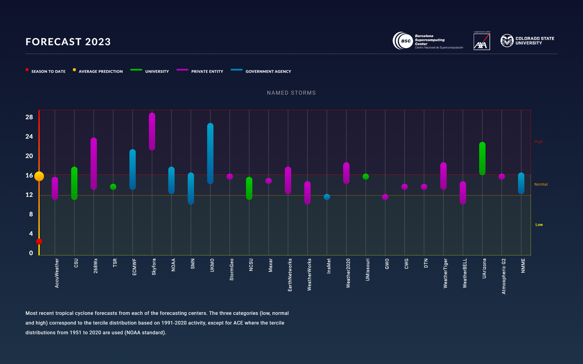
The consensus for the upcoming season is “near average.” What does that mean? A consortium of AXA XL (a reinsurer), Colorado State University, and the Barcelona Supercomputing Center have been aggregating seasonal hurricane forecasts for a few years now. These forecasts come from the private sector, government agencies, seasonal models, and universities. They have a great site where we can get almost a consensus forecast for the upcoming season, as well as see the outliers (what we refer to as an “ensemble forecast” in meteorology). The consensus for this season (which is two storms deep as of today) is for roughly 16 named storms, 7 hurricanes, and 3 major hurricanes, which is near what an “average” season would produce.
I personally tend to put a bit more weight on Colorado State and NOAA’s outlooks because they’ve been at it for a long time, and they offer a good deal of insight into their processes. I will also speak highly of Weather Tiger, run by Dr. Ryan Truchelut. He also has a tropical newsletter, focused on Florida a lot but no less interesting that you may want to add to your repertoire. In my work in the energy industry, I have also crossed paths with CWG (Commodity Weather Group), Maxar, and Atmospheric G2 who all do good work in this space. You do this long enough, and you can find reasons to like or dislike any given forecast. Whatever the case, feel free to explore the individual forecasts there, but the consensus (16/7/3) is about as good as it gets right now.
That said, it’s complicated. Tomorrow, in part 2, we’ll talk about El Niño, and what it may mean for the season ahead.
This is great stuff, Matt. Kudos!
Thanks. Live in Florida, near Tampa, and appreciate information from reliable sources. Keep up the good work!
Dang…makes my “head hurt”…my problem, not yours…lot of good stuff…Matt, really appreciate your work…thanks…