One-sentence summary
Tammy will impact the Lesser Antilles with gusty winds and heavy rain this weekend, while Norma clips Baja tomorrow as a fading hurricane.
Tropical Storm Tammy will scrape the northern Lesser Antilles before heading out to sea
Tammy remains a 60 mph tropical storm this morning, and it is one that is struggling a bit to really get itself in a mode to intensify quickly. That’s good news for sure, but a slow intensification remains likely, so Tammy is expected to still become a hurricane over the Leeward Islands tomorrow.
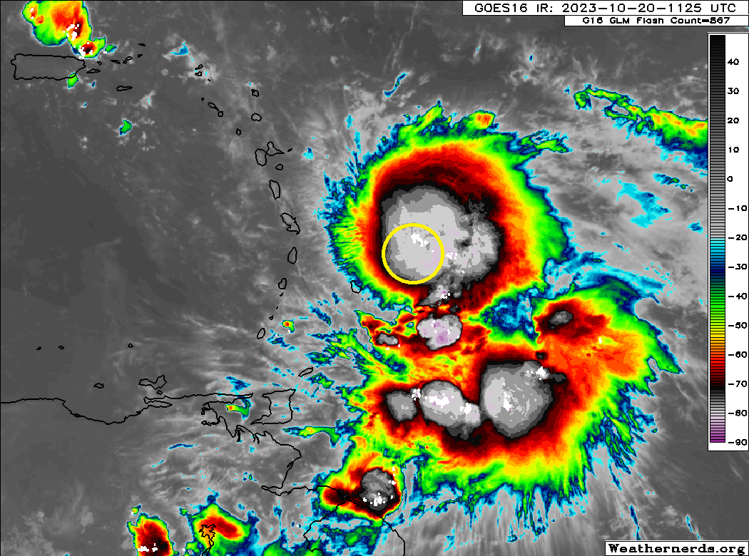
You can see from the satellite image above that the majority of Tammy’s storms are displaced somewhat to the east of the center. This spares most areas for now, but that will likely change as Tammy creeps northwest.
Numerous watches and warnings are posted for the Lesser Antilles and conditions are expected to be at their worst over the next 36 to 48 hours before Tammy lifts north enough to start pulling away.
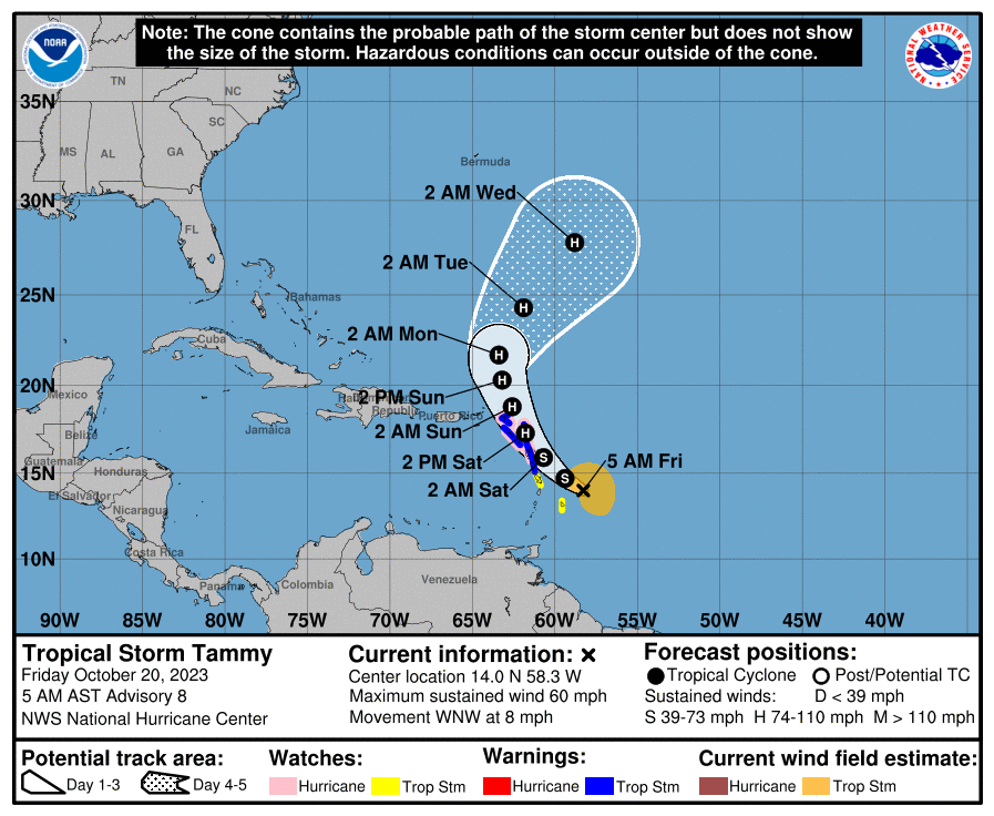
What to expect in the northern half of the Lesser Antilles? Obviously you’ll see rough surf and some high tides there. Tropical storm force winds will approach from the south and east into tonight and tomorrow. At this time, I don’t necessarily expect much wind to get any farther west than Anguilla or St. Kitts and Nevis. Obviously, continue monitoring Tammy this weekend in Puerto Rico and the Virgin Islands, but for now any direct wind impacts seem minimal to unlikely.
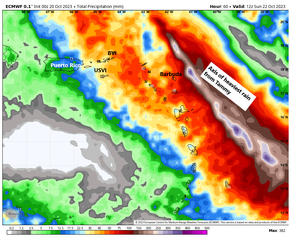
With Tammy’s thunderstorm activity a bit lopsided to the east and a track taking the center near or just east of the Lesser Antilles, the heaviest of the rain will also probably stay east of most of the islands. Still, locally heavy rain is likely with flash flooding a possibility across the northern islands and even perhaps into Puerto Rico and the Virgin Islands as well. There is an elevated risk of excessive rainfall across Puerto Rico today from isolated to scattered thunderstorms. That risk may continue this weekend even with Tammy staying comfortably east of the region.
Tammy will exit north of the islands by the end of the weekend. While it’s expected to slowly head out to sea, Tammy might get left behind well north of the islands, allowing it to meander over the open Atlantic. Tammy will intensify further north of the islands until shear begins to enact a toll on Tammy next week. Despite being comfortably away from land, Tammy may continue to produce rough surf on the north-facing shores of the Caribbean islands.
Hurricane Norma has peaked but it will deliver impacts to Baja and Sinaloa
Norma has peaked in intensity and is now slowly weakening. That said, it’s still a category 3 hurricane with 115 mph maximum sustained winds.

Despite this downward trend in intensity, Norma is still expected to be a hurricane as it approaches Baja on Saturday. Norma will come close to making landfall in Baja before curving to the east toward mainland Mexico and coming ashore there as a tropical storm or depression.
Heading to Cabo this weekend? Check ahead to make sure everything is copacetic, but impacts there should be moderate with gusty winds and heavy rain.
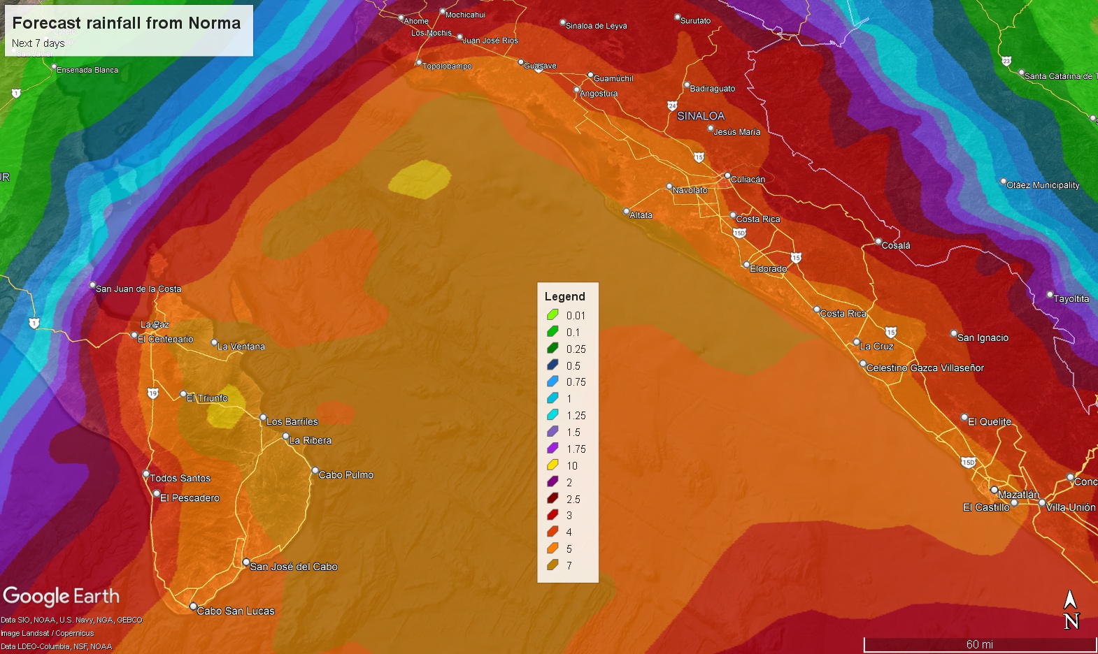
Rain totals are shown above for Mexico, with the heaviest rain on the southeast tip of Baja and in coastal Sinaloa.
Winds of hurricane-force are possible in Baja as Norma passes but mostly tropical storm type impacts are expected from wind.
What weather is on our radar for next week?
Next week looks a little more active across the U.S., but the tropics should settle down. Here are the things we’ll be watching.
Tropics: What exactly does Tammy do in the Atlantic? We expect Tammy to go north and out to sea, but as noted above, a handful of models do “trap” it between the Caribbean islands and Bermuda. This would not impact land at all, but it might inject some forecast uncertainty into the picture. Beyond that, we don’t expect any other real notable systems in the Atlantic or Pacific.
Rainfall: There should be a substantial amount of rain with a cold front and some moisture from Norma and the Pacific across portions of Texas into the Plains early to mid next week.
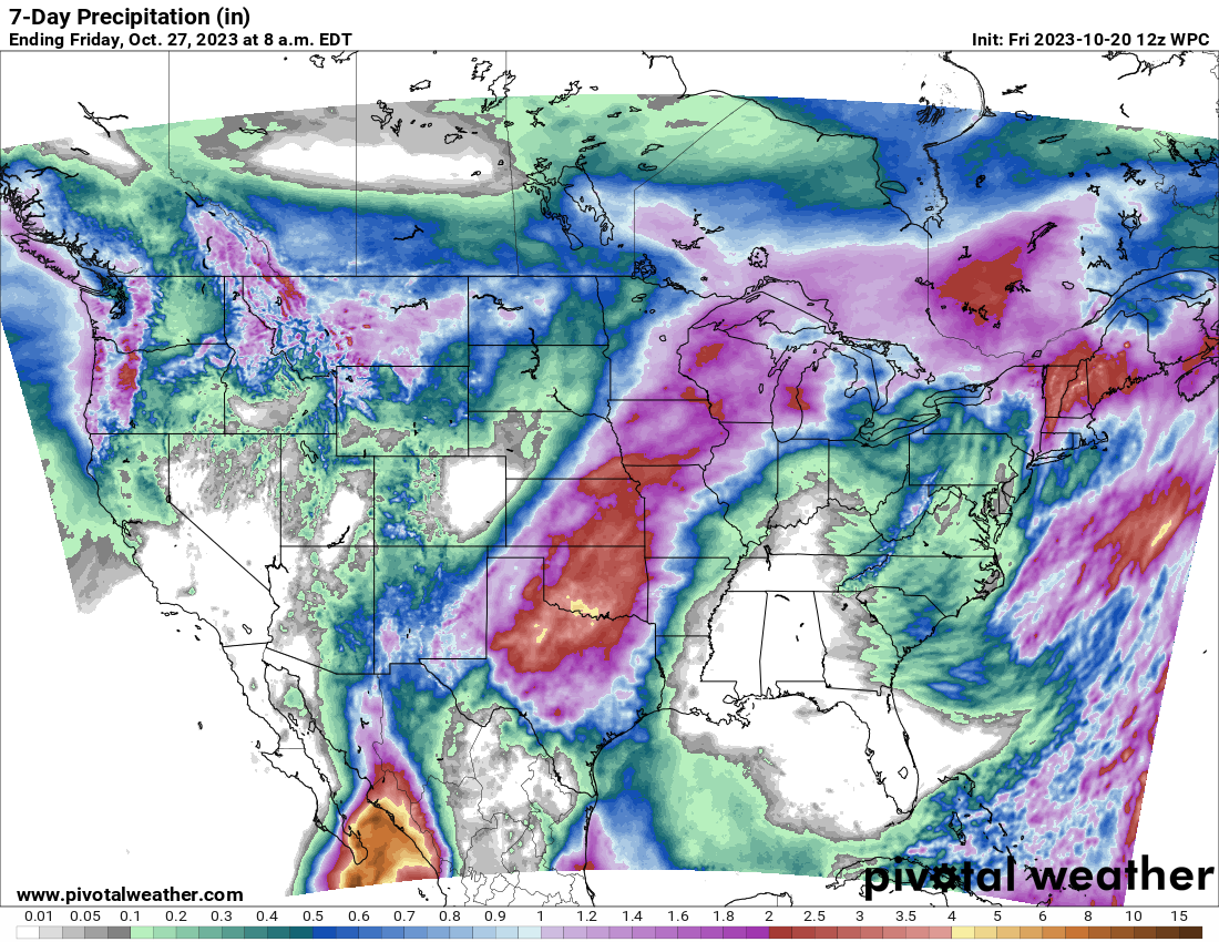
Totals of 1 to 4 inches with isolated higher amounts seems reasonable.
Severe storms: Significant severe weather is not expected next week, but we will keep tabs on the Plains for some isolated potential with a stalled out front in the area.
Snow: There is some potential for a healthy dose of snow in portions of Montana’s mountains, specifically near Glacier National Park and the Lewis Range next Wednesday and Thursday. There’s a slight chance some of that will expand into other high terrain south and east of Glacier late next week.
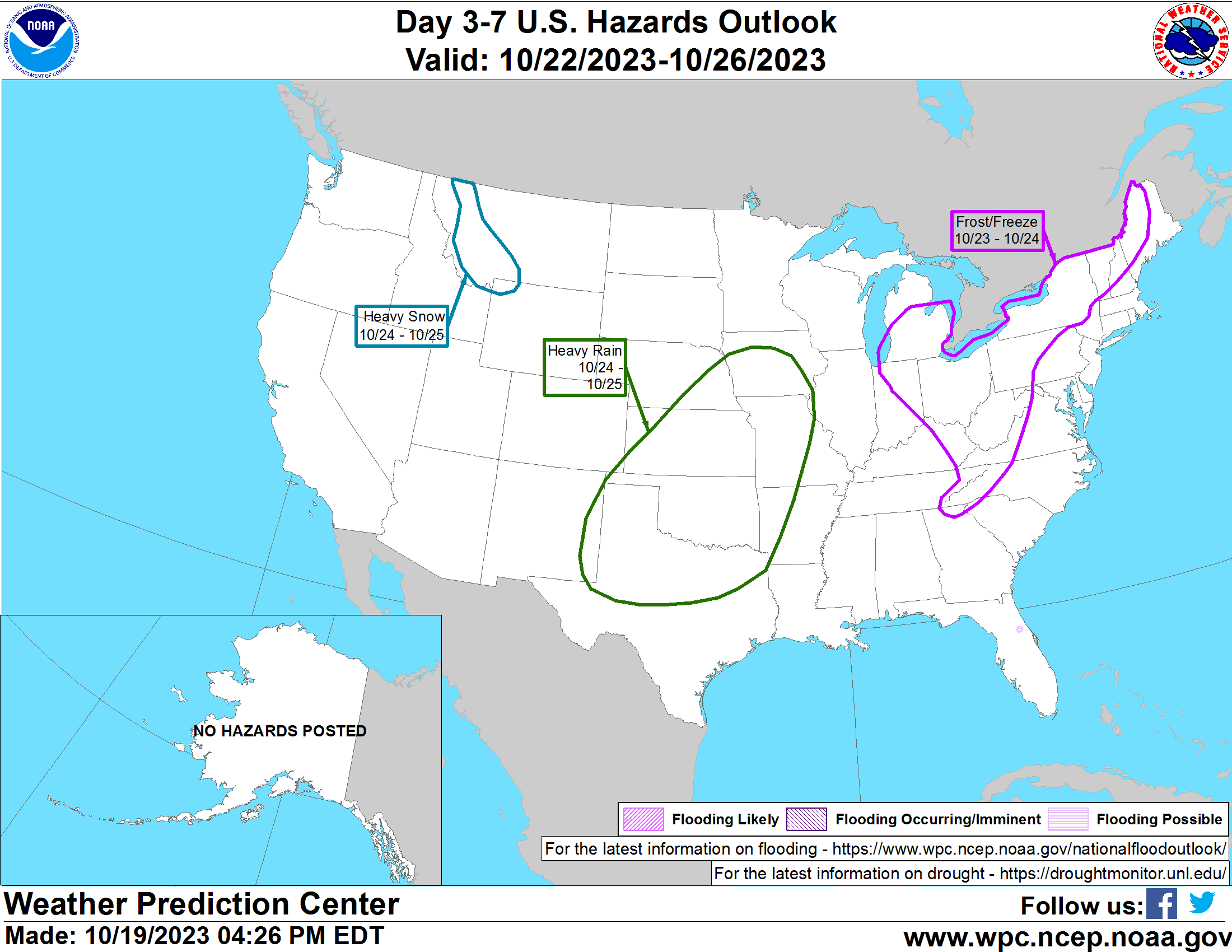
Temperatures: Ahead of the cold front next week, we have the potential to set some record warm minimum temperatures in the Central U.S. into Texas. Nothing too extreme, but it will not feel like autumn everywhere.
Thanks for the great information! I always learn so much here 💜
🌬🍂🍂🎃🍂🍂
How does the forecasted number of tropical storms & hurricanes compare to what has developed this season?
What is Houston’s current drought rating?
Houston is still in significant drought, but the city has improved a lot, and the most extreme drought is generally west of Katy and Cypress now. The number of storms appears to be near the higher end of forecast ranges, if not above them. I believe 20 storms is more than most anticipated. A couple were throwaways, but in general, you can assuredly describe this season as active.