One-sentence summary
The tropics refuse to go away quietly, with Pilar in the Pacific and a potential Caribbean system later this week that bears watching in Central America.
Atlantic update: Invest 96L unlikely to do much, but the Caribbean bears watching later this week
We are watching two areas in the Atlantic at the moment: Invest 96L near the Bahamas and a yet-to-develop system in the Caribbean. Let’s run through them.
Invest 96L
Though this is the most immediate item on the menu, it’s not the most notable. 96L was found with gusty winds but no real circulation to hone in on yesterday, so it remains just a disturbance. But it’s about to get smacked in the face by dry air and wind shear, as the much discussed significant U.S. cold front comes sweeping offshore tomorrow.
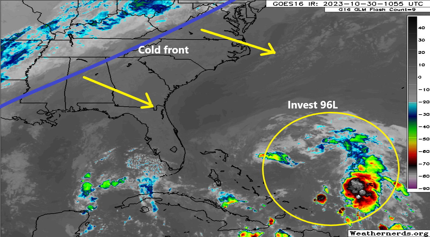
This should knock 96L out to sea and probably prevent any real development at all.
Caribbean
Despite their noisy operational guidance shows, both the GFS and European models are in decent agreement right now that a surface low pressure system is going to form in the Caribbean around midweek. It will drift west in the coming days toward Central America. Both sets of ensembles (which run the models 30 to 50 different times) show a favorable setup for development, but the GFS is tending to run “hot” right now, developing it slowly but intensely as it comes west. The Euro? Not so much. But this has been an issue throughout hurricane season. The GFS does tend to overcook Caribbean systems this time of year, and the Euro has tended to have an underforecast bias when it comes to intensity. To me, that argues for some type of developing tropical system in the western Caribbean by the weekend.
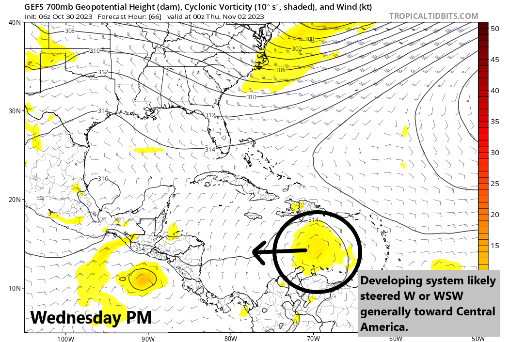
In general, I would expect this system to be steered generally west, if not even a little south of west around the periphery of sprawling high pressure that will extend from south of Bermuda across the Bahamas toward Cuba and the Yucatan this weekend. Exactly how far west this gets, how strong it gets, and where (if) it makes landfall is to be determined, but interests from the Yucatan and Belize south into Honduras and Nicaragua should probably be watching this rather closely in the meantime. We’ll update with the latest tomorrow.
Pacific Update: Pilar will likely bring heavy rain to El Salvador
Tropical Storm Pilar formed last night in the eastern Pacific. Over the next couple days it will drift toward El Salvador and Honduras. Tropical Storm Watches are posted there and Nicaragua. Pilar is not currently expected to become a hurricane, and it will primarily bring tropical storm conditions and heavy rain to the Pacific coastal communities between Guatemala and Nicaragua. Heavy rain could cause flooding and mudslides in some of these areas.
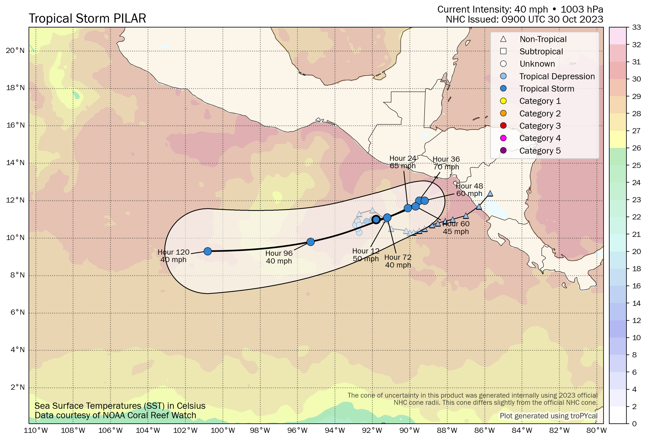
Elsewhere in the East Pac, we don’t expect any significant development through the week.
U.S. Weather: Frost & freeze & Santa Ana winds in California
If you look at a National Weather Service hazards map of the U.S. right now, one thing sure stands out: Frost and freeze alerts all over the place. Freeze warnings extend from the Mexico/New Mexico border up into Ohio and Pennsylvania.
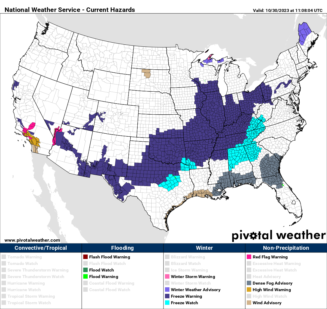
Some cold nights are ahead this week with the first true wintry-type air mass of the season across the Lower 48.
And as is often the case, when cold air dumps into the Rockies and points east, Santa Ana winds are kicking up in California, leading to warm weather and critical fire danger today, particularly in the higher terrain around Los Angeles and into Ventura County.
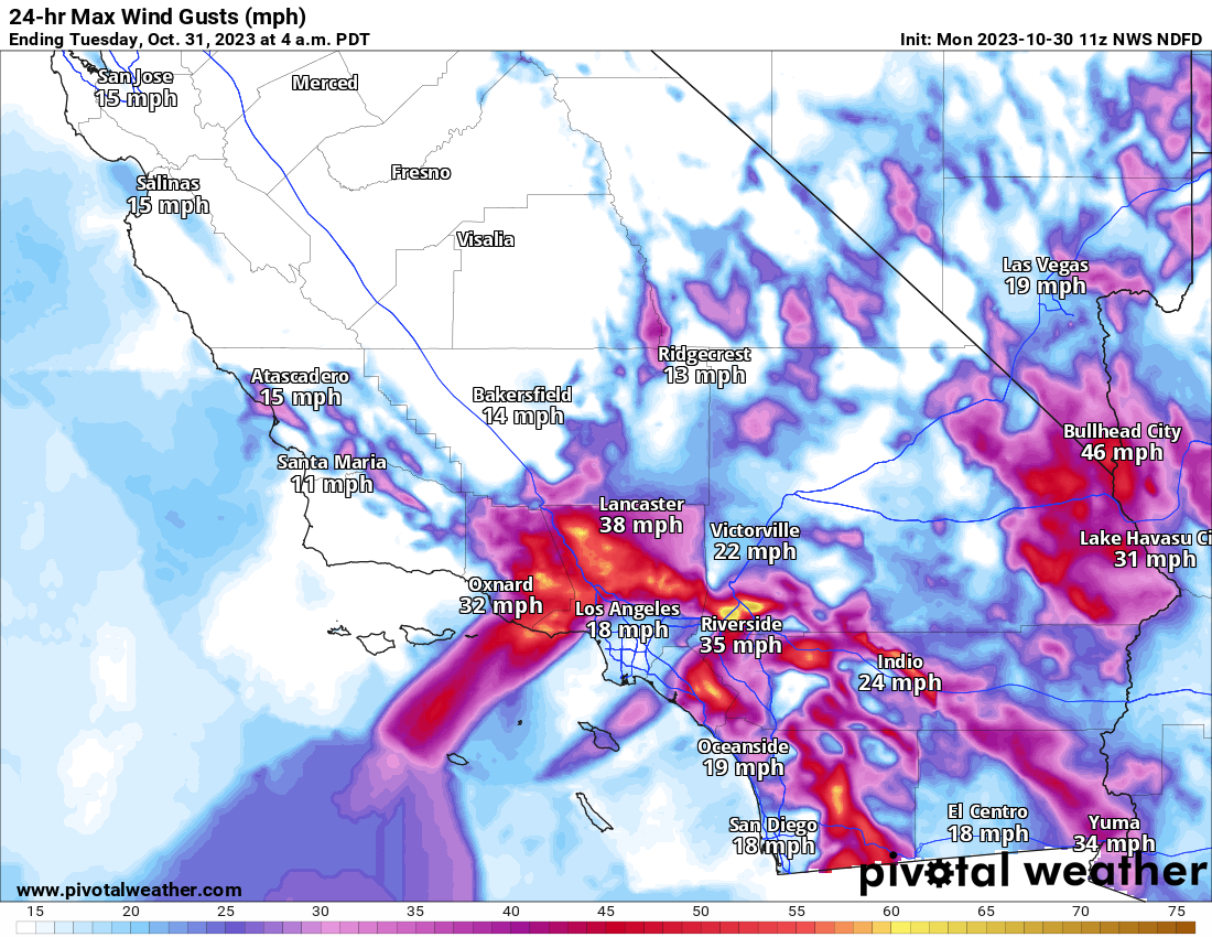
We’ll hope for nothing serious in that part of the country. Winds should settle down on Tuesday.
Otherwise, it looks like a relatively quiet week nationally. A storm will enter the Pacific Northwest around Thursday, bringing heavy rain and mountain snow. Snow levels will be relatively high with these storms. That may be followed by a second or third system this weekend.
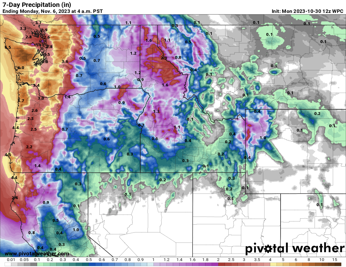
We’ll keep tabs on all that as well.
Are there any maps on the internet that show temperatures in Texas or even the US?
I am partial to this one that’s interactive. https://www.wrh.noaa.gov/map/?&zoom=9&scroll_zoom=false¢er=29.803709563173605,-95.34210205078126&boundaries=true,true,false,false,false,false,false,false,false&tab=observation&obs=true&obs_type=air_temp&obs_popup=false&obs_density=40&obs_provider=ALL
Very nice map. Thanks very much.