As a meteorologist, weather in general fascinates me. I worked two years in California about 15 years ago, and when I took that job, everyone teased me, saying the weather was “so easy” to forecast. And, yes, about 80 percent of the year, conditions are pretty stable overall. There is nuance to that. Most people may not realize a minor difference in temperature from day to day, but it’s something that can be reflected in power usage. Same goes for wind or solar output in terms of forecast weather for wind farms or solar facilities. But what always kind of fascinated me about the West was water.
So far, 2025 has been a mixed year in the Western U.S. On the one hand, California snowpack is doing great.
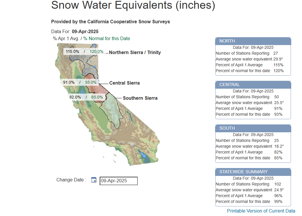
It’s been a late season bonanza up north, with snowpack levels sitting at 120 percent of average north of Lake Tahoe. The central Sierra are a little less well-off but still close to normal. The southern Sierra have not had their best winter ever, but even still snow water equivalent is around 85 percent of normal. There have certainly been worse years in California.
It’s when you get into the interior West that the problems start. Take Colorado. Their peak snowpack is likely to be the lowest since 2018. The northern part of the state has done well with near average snowfall this year.
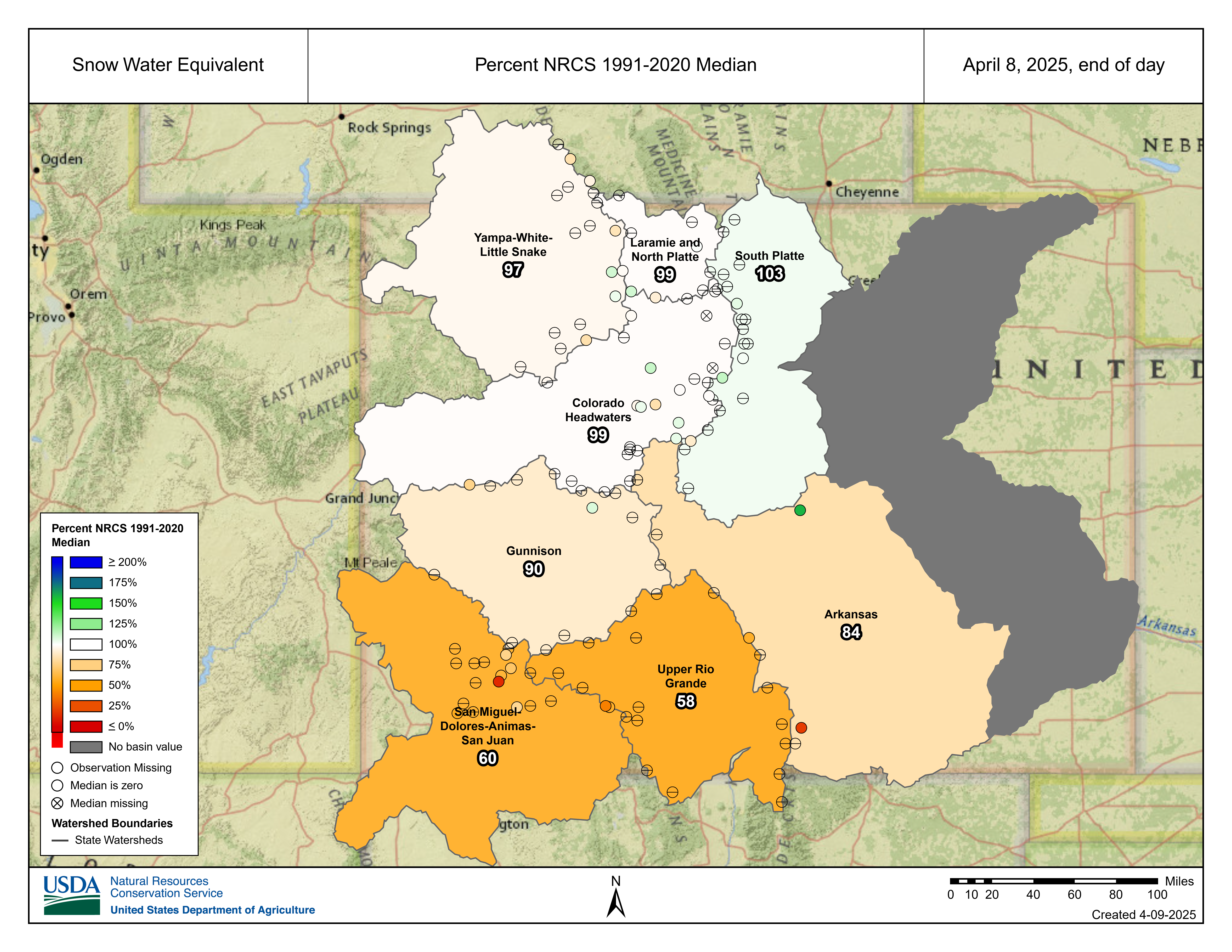
The Colorado River headwaters are also running near average, but southern Colorado, particularly the San Juan and Upper Rio Grande basins are in bad shape. Snow water equivalents are running about 60 percent of the median right now, or well, well below average.
The story improves some in Utah, where the basins are a little noisier, but in general not in bad shape outside of southern Utah. Similar story in Wyoming and Idaho. Not great, not terrible. Oregon? Fantastic winter. Washington? Less so. But for Arizona and New Mexico, it was a dreadful winter.
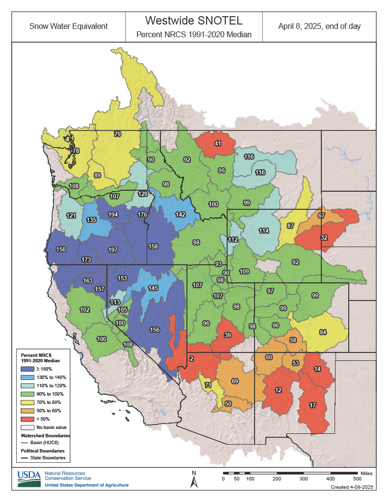
Flagstaff, Arizona has seen 51 inches of snow this winter, compared to a normal of 86 inches typically. In Albuquerque, they’ve had 1.68 inches of rain since October 1st, compared to 3.38 inches on average. It’s turning out to be pretty bad. Snowpack is particularly important because as the seasons change, that snow melts and it feeds the rivers of the West and subsequently the reservoirs, farms, and hydroelectric power that is scattered about. The relationship is not 1-to-1, where 100 percent of snowpack means streamflow of 100 percent. Even though the upper Colorado Basin saw decent snow, with nearly 100 percent of normal, the forecast streamflow from CLIMAS is only 84 percent of normal.
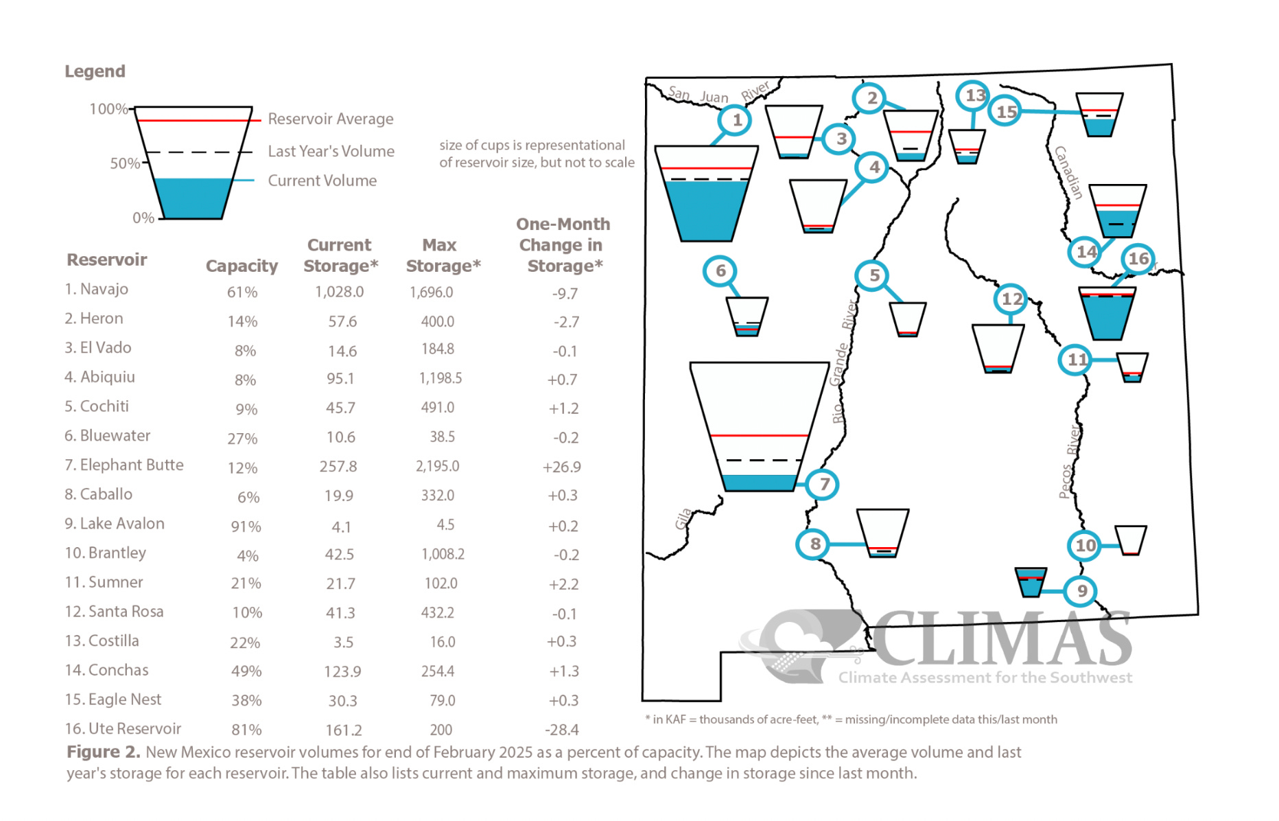
For the Rio Grande it’s even worse, with the CLIMAS streamflow forecast being only 52 percent of normal! Laura Paskus, who writes an excellent blog focused on New Mexico recently shared the image above from the CLIMAS March report showing reservoir levels in New Mexico. They are not good. At all.
Suffice to say, there have been glimmers of hope in recent years from some strong winters — but the underlying problems are not going anywhere in the West. There is still a shortage of water, and there is high risk that this will only get worse in future years. Absolutely reckless and illogical decisions like releasing water in California earlier this year may not seem like a huge deal on the surface, but every single drop is precious in the West. As it is, the situation regarding water is already tense. The states that utilize the Colorado River are up against a clock to come to an agreement on a joint management proposal by May. A quasi-handshake agreement that had been in place with Mexico for a shift in water delivery to Tijuana from the Colorado was rejected for the first time in 80 years this year because of complaints that Mexico is not supplying enough treaty-mandated water to Texas from the Rio Grande.
All this underscores the very, very tenuous situation in the West. I hope to include some additional coverage or words on this topic in the future here because this problem is not going to go away anytime soon, and if anything, it’s going to continue to worsen. Water doesn’t recognize borders of states or countries, which makes it an especially challenging and precious commodity to wrangle.