Headlines
- Tropical Storm Oscar will continue to dump heavy rain on parts of Cuba and the Bahamas as it exits out to sea this week.
- We take a look at why we wrote Invest 94L off on Friday before it became Oscar, and in our Monday morning quarterbacking, we look at hints we could have missed.
- Conditions may become favorable for further tropical development next week in the western Caribbean; we discuss who is usually still on the hook in early November.
Tropical Storm Oscar’s route to surprising us
Oscar is still lashing parts of the southwest Atlantic with heavy rain and gusty winds today. According to Michael Lowry, Oscar was indeed the smallest known Atlantic hurricane on record. He also accurately described Oscar’s development pathway as “nightmare fuel” for forecasters, and this forecaster could not agree more. Oscar went from nothingness to probably a category 2 or even 3 microstorm over the course of hours. This has happened in the Pacific as recently as this past summer with Hurricane John. To a lesser extent, we saw Otis last season defy forecasts and go ballistic to a category 5 storm. But every so often these storms serve as a reminder that modeling is imperfect, very imperfect.
Here’s an animated loop of Invest 94L’s forecast from the GFS model last Friday morning. You can see it takes 94L/Oscar to the west over the Turks and Caicos Islands north of Hispaniola but never develops the system and has it fall it apart rather quickly.
The European model from Friday morning offered a somewhat more realistic outcome, but even it did not look foreboding at the time and probably justified somewhere between a 10 and 30 percent chance of tropical development.
Still, a minimum pressure of around 986 mb was reported over the weekend from Oscar, well under the minimum of about 1003 mb shown here on the Euro. Somewhat surprisingly, the European AI model did fairly well here, or at least was somewhat similar in nature to the Euro shown above. The ICON model did not do well, which marks one of its worst forecasts of the season.
I am somewhat intrigued by the European performance though. Small storms are tough to forecast, and we’ve noted in the past that model resolution has a lot to do with this. You simply cannot capture a hurricane that is basically the size of a typical thunderstorm complex. However, there remains something of an “art” to forecasting where one can paintbrush in some accents to improve on an otherwise finished canvas. This is a situation where looking at the Euro probably would give most of us some pause at least for writing something off. Perhaps that’s something I should have noticed more back on Friday. There are whispers of 2007’s Hurricane Humberto in cases like this. I think it just goes to show you never to take anything for granted in the tropics. You’re constantly humbled in this world.
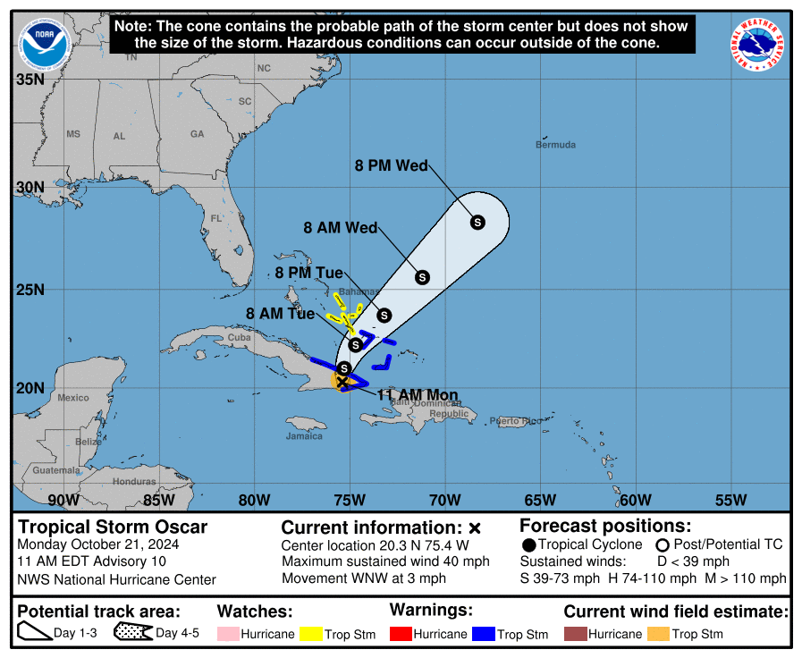
Anyway, Oscar will turn back away from Cuba and head out to sea over the next day or so. But it will dump extensive rainfall over Cuba and the southeast Bahamas.
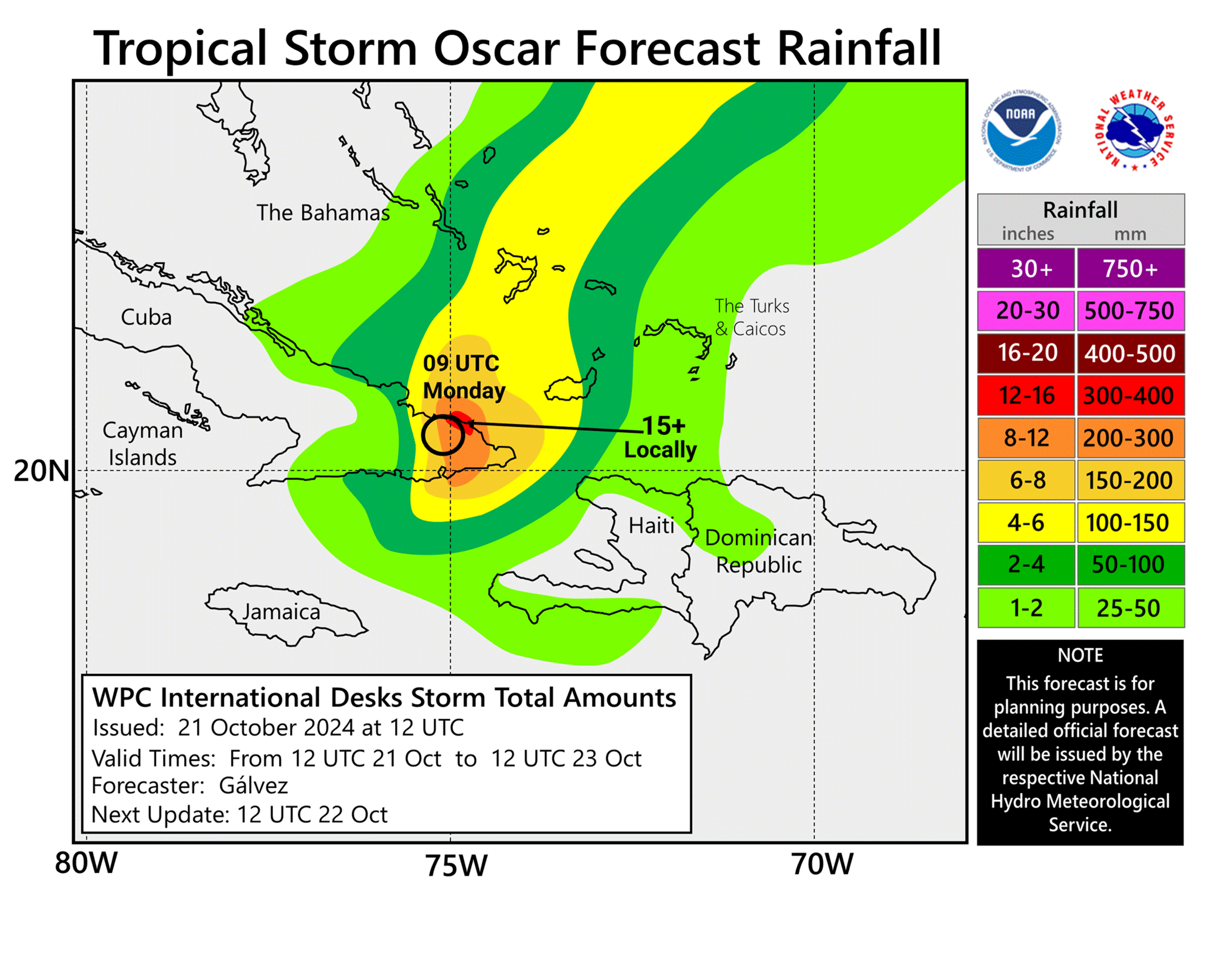
Rains in excess of a foot (300 mm) are possible for small portions of southeast Cuba and up to 150 mm in the southeast Bahamas.
Beyond Oscar: Quiet, then what?
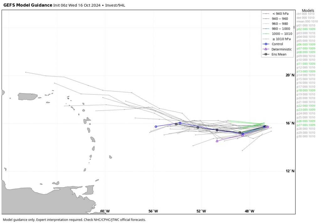
No additional tropical development is expected across the Atlantic for the rest of this week. Typically, we would begin talking about the season shutting down around now. While November storms do happen at times, they tend to be infrequent, and on an ACE basis, hurricane season is now 90 percent over. And after this week it will be about 93 percent over. But that said, the background state of the Atlantic appears as if it is going to get more favorable for development again just as we head toward November. Where would you expect storms to form in November?
Typically, you’d look in the open Atlantic north and east of the Caribbean or in the Caribbean, just east of Central America. The latter area is the one to watch heading into November, as numerous ensemble members are beginning to pick up on activity there. Where it goes is TBD, but the water in that area remains very, very warm, which could more than support a significant storm for portions of the western Caribbean, perhaps including Central America. These storms typically get brushed off to the north and east relatively quickly by wind shear and cold fronts, so the western Gulf is probably off the hook. The eastern Gulf should still keep an eye on things, but the Caribbean should definitely keep tabs on anything that tries to develop next week. For now it’s just speculation and model hints. We’ll keep you posted as things clear up some closer in.