One-sentence summary
Idalia is expected to become a tropical storm again as it approaches Bermuda, while multiple other systems out there are of no land concern at the moment.
Post-tropical Idalia
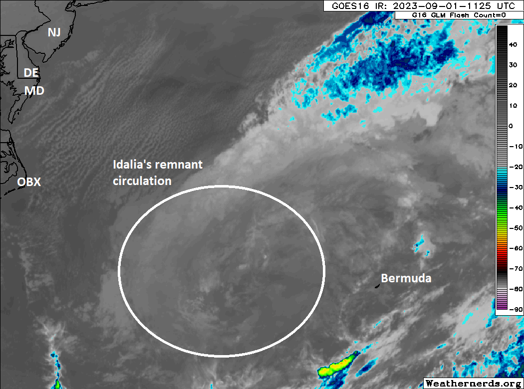
Idalia is in a post-tropical phase currently, meaning it’s no longer a “warm core” system feeding off of warm water. Basically, Idalia is an “extratropical cyclone” without thunderstorms and with fronts, akin to a broad nor’easter off the East Coast.
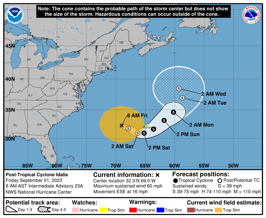
Over the next couple days, Idalia will wander toward Bermuda, eventually probably feeding off the warmer water near the island, which could (should?) allow it to regain tropical characteristics and become a tropical storm again. As Idalia does this, there could be periods of heavy rain and gusty winds on Bermuda. Tropical Storm watches are posted for the island. This is probably not going to be a damaging storm there, but frankly if you have a trip planned to Bermuda over the next few days, I have to apologize.
One other note on Idalia: Because it has grown quite large in size, it will likely continue to churn up rough seas off the U.S. East Coast. This will probably keep rip current risk high for the holiday weekend, so if you are beaching it there this weekend, please use caution in the water. Rip currents can be very dangerous.
Lastly, what does Idalia do beyond Bermuda? Yes. That’s the answer. Yes.
In all seriousness, there is a huge disparity in model guidance regarding Idalia’s track forecast after about day 4 (Monday/Tuesday).
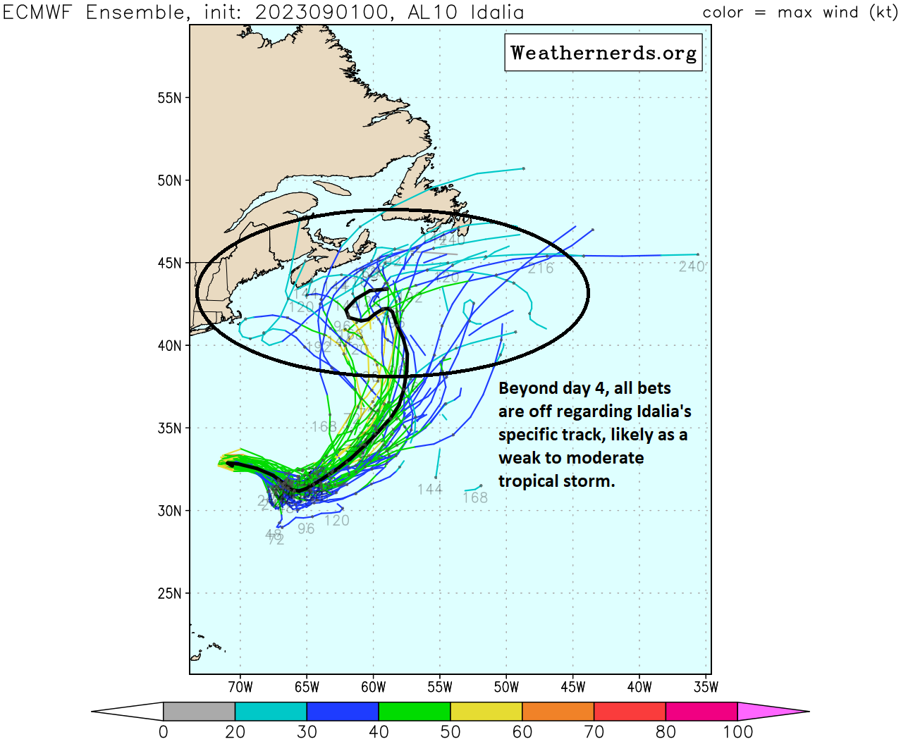
Once Idalia passes Bermuda it will be subject to the whims of building high pressure in the central Atlantic and whatever steering flow is present in the northwest Atlantic. Because there is a lot of action in the Atlantic right now, it makes the pattern forecast into next week a little challenging to decipher with specificity. We’ll call it convoluted. Could Idalia turn left and head to New England? Certainly. Could it head out to sea? Certainly. Could it just meander and eventually fall apart? Certainly. Anyone speaking with confidence on this right now is not serious. We’ll watch it through the weekend and see how this evolves. We’ll keep you posted this weekend as well.
Franklin and Jose and Gert and 94L
Franklin, Jose, and Gert need to learn a thing or two about personal space. Because right now, they’re not really giving any of that to each other.
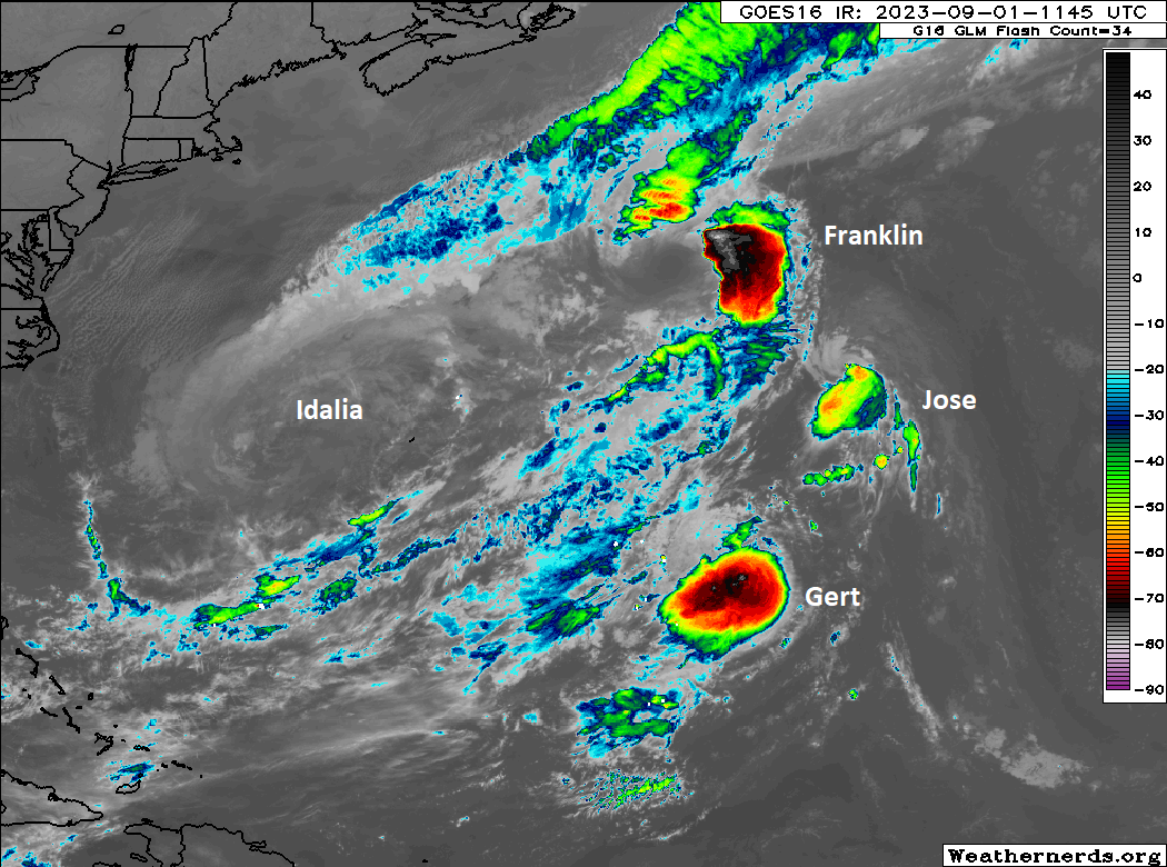
Remember Tropical Storm Gert? Of course you don’t. It formed a couple weekends ago, then dissipated, and managed to fester long enough to regenerate this morning back to Tropical Depression Gert. It’s just southwest of Tropical Storm Jose, which is just southeast of Hurricane Franklin. Neither of these is a threat to land. All of these will have some impact on the broader pattern in the Atlantic. Alas.
Meanwhile, east of all this, occupying its own personal space is Invest 94L, which should become Tropical Storm Katia today or tomorrow. It is also of no threat to land.
Next week’s next wave
Lastly, we continue to have visibility in modeling on the next tropical wave which may develop by mid to late next week in the central Atlantic. Given the potential location of this wave, it probably is worth keeping tabs on in the islands for next weekend or late next week.
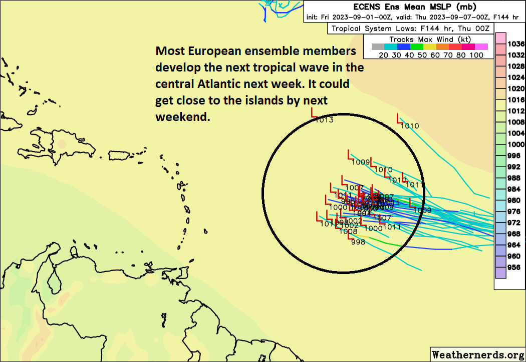
Modeling seems to be in good agreement on this area developing and potentially getting close to the islands by next weekend or so. Its track will ultimately be determined by exact placement of features in the Atlantic and how strong the system itself can get. These are questions we can’t answer right now. We’ll watch it through the weekend and update with more once we get some clarity.
I know this sounds more like Hollywood movie material but could the three storms next to each other merge?
Nope. They would actually repel each other and probably create destructive interference.
Oops! That was Franklin, Jose and Gert, not Juan. Was this a test?
You passed the test! I made a typo. It’s fixed now. Thank you!
THANK YOU for this continuous coverage of the hurricane season. I love your humor and human side of reporting!
Thank you!
I think there is a typo in the first sentence after the header “Franklin and Jose and Gert and 94L”. Who’s Juan?
Thank you! Corrected. Juan was a 1985 storm I happened to look at recently and for some reason I can’t shake it.
If Katia pops up while the other four are still churning, that would make five named storms at once. Would that be a record?
I don’t know for sure but I think it would be close.
I’m pretty sure you can find images of 5 storms marching across the tropical Atlantic from the 1995 season…..also note, far more impressive storms, too. I would imagine a few other active seasons had similar images, too.
It’s going to be interesting watching them and what they do given the extreme warm waters of the Atlantic.
Good news is that the wind shear in the Gulf is supposed to increase next weekend according to models and the CFS Weekly suggests that this will continue in the coming weeks.