One-sentence summary
While the final forecast for Lee is no clearer today than it was previously, there are some signs that we can begin to hone in on a region more likely to see Lee eventually.
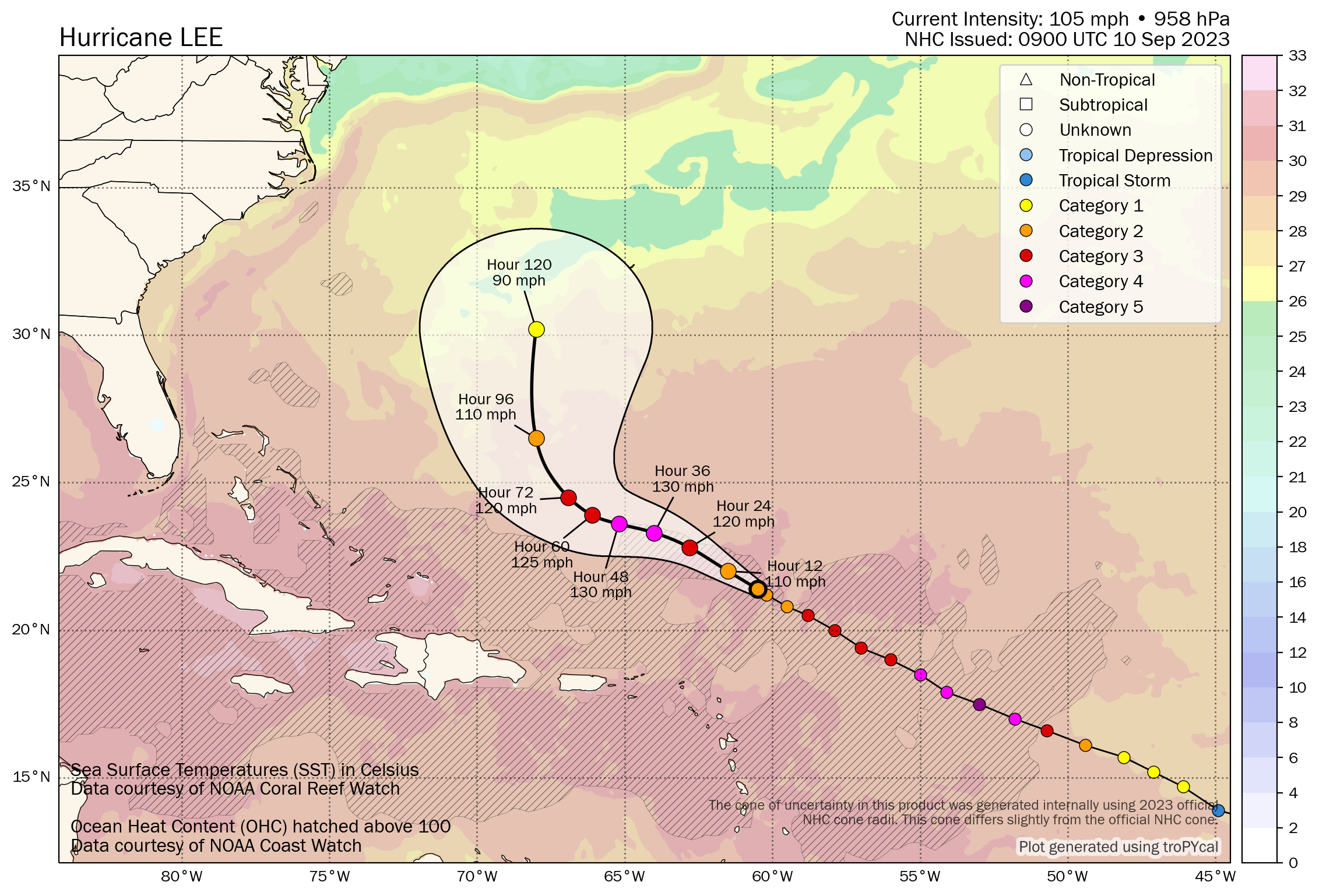
Hurricane Lee: 105 mph, moving WNW 9 mph
What’s changed since yesterday?
Lee has continued to have to battle shear, and as a result it has weakened back to a category 2 storm with 105 mph winds. Lee has also slowed its forward speed down as expected by about 5 mph versus yesterday.
Everything else is mostly on track as forecast.
Lee’s intensity forecast
I had sort of expected to see that Lee would organize a bit more yesterday evening, but that failed to materialize. Modeling suggests that shear may relax a little over Lee, but I’m wondering if that ever happens. The direction of the shear may change, which could, I guess, lead to some readjustment on the intensity outlook here. In general, modeling forecasts intensification again over the next 2 days or so before a slow weakening trend. Lee will probably compensate a bit for weakening by growing its wind field over the next week as it goes north.
Lee’s track forecast
I’ll preface this by saying that confidence in Lee’s final outcome isn’t higher today than it was yesterday. However, there have been a few trends worth noting. First, the forecast track of Margot seems to have come into better agreement among models since yesterday, taking it more straight north than north-northwest. This tends to reduce the odds of an interaction with Lee. Perhaps one less variable in the equation then.
Second, there seems to have been a bit of a boost in agreement in Lee’s track as it comes north, or what I would say is “less spread” in the track. We now have ensemble modeling in moderate agreement on a track aimed broadly toward Nova Scotia late.
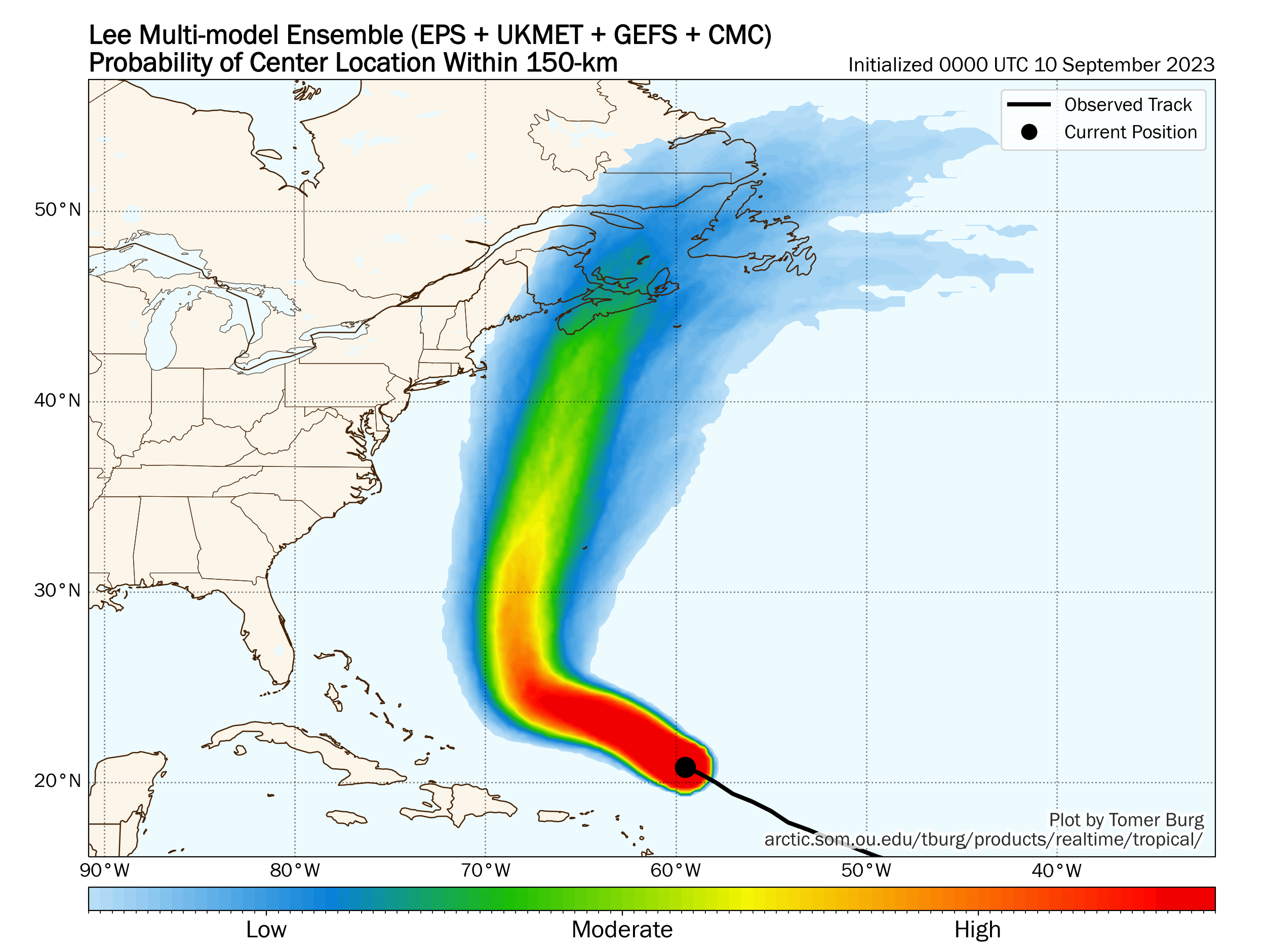
Now, a few big things to note here. First, just because we now have moderate track agreement toward Nova Scotia does not mean a.) that Nova Scotia is the target for Lee when it comes north or b.) that impacts will not be felt far outside that track. The ultimate track of Lee continues to bounce around in both time and space. The timing differences have narrowed a bit today along the track of Lee, which means by tomorrow or Tuesday we can probably peg the timing of impacts a bit better. Secondly, while most modeling broadly points it to between Downeast Maine and Nova Scotia, it does not mean that Cape Cod or Newfoundland can unplug here. There is still a wide array of tracks and options, including a handful that try to nudge it back northwest toward even Long Island or southern New England.
So, we’ve been slowly “clearing” places from Lee, and I think today that may include North Carolina. Modeling shows this staying well east of North Carolina now, so from there south to Florida, this isn’t your storm. Bermuda? Still needs to watch closely. I would probably continue to watch this from Virginia to New Jersey, watching it fairly close from Long Island through Rhode Island, and watch it very close between Cape Cod and Newfoundland, including New Brunswick and Prince Edward Island.
Again, no one knows for sure where Lee will go. The best we can do is gradually narrow the focus a little. In the meantime, expect rough surf and rip currents to be prominent issues in the Bahamas, Bermuda, and up and down the East Coast this week. More on Lee tomorrow.
Margot and 97L
As I noted above, Tropical Storm Margot’s track is coming into better focus today. Margot is expected to go basically due north or maybe just slightly west of due north over the next several days. It is also expected to become a hurricane.
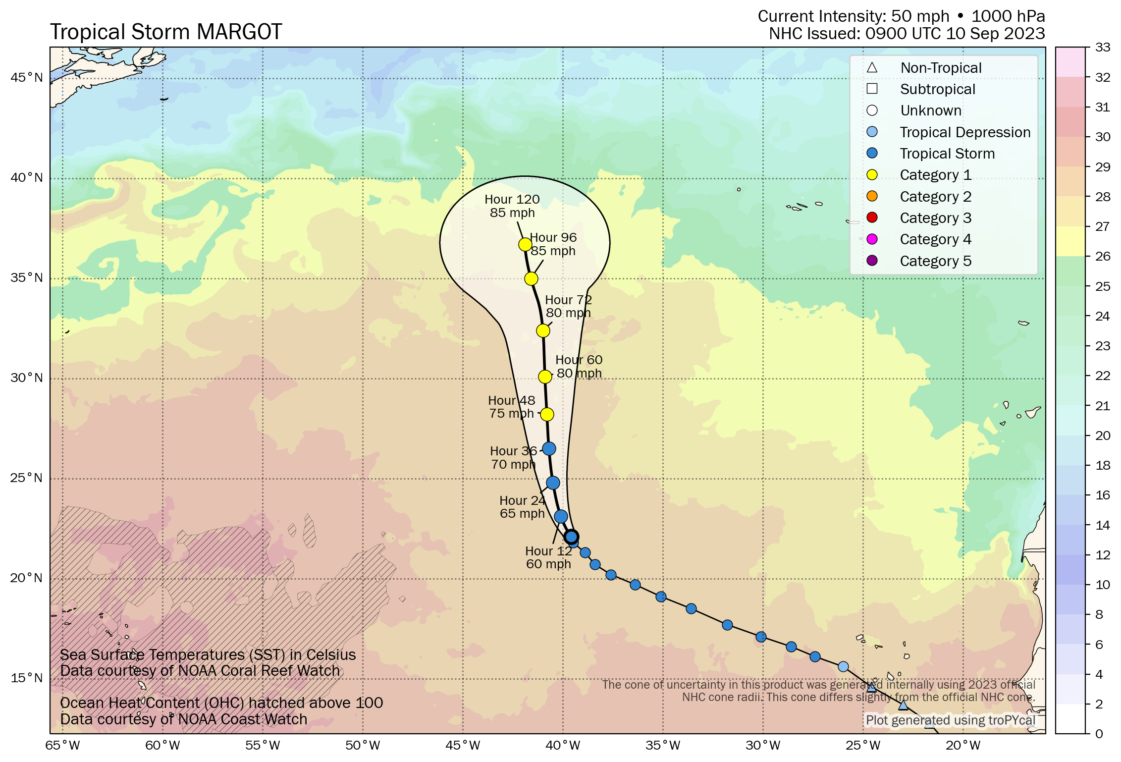
Margot is still not expected to impact land.
Behind Margot, we have now established the new Invest 97L, which is located just west of the Cabo Verde Islands. Some operational modeling has gone wild with this one, bringing it to the Gulf or up the East Coast. We continue to not really see that as a major concern right now. We’ll keep tabs on 97L, but the odds of developing are only around 30 percent or so in the meantime.
Otherwise, the Gulf and Caribbean continue to look quiet for the next 7 to 10 days or longer.
As a coastal NJ resident, I really appreciate your forecasts and explanations. It’s refreshing to have a non-sensationalized source of information. I’ve shared it with all of my like minded friends and neighbors. Thank you!!
Thanks, Steve! And double thanks as a native of the Jersey Shore myself!
My last two newsletters contained no content, but linked to this web page. Is that a flaw or a feature?
Not just you
I noticed too
Mine haven’t had content or a link, just the title of the post then empty
Hey Pat…this is apparently a feature for some (I’ve had no issues, as have some others I’ve asked). But we’re putting in a help ticket to see what’s going on. Sorry for the inconvenience!
Today is the peak day of hurricane season. What’s the outlook for the Gulf of Mexico for this season?
We have strong wind shear for the month. So likely lower than normal chance of impact.
I am wondering if it is the jet stream that comes more south this year.
Hey Chris. We noted at the end of the post that the Gulf looks quiet for the next 7 to 10 days “or longer.” How much longer? I don’t want to say ha. But for the time being at lest, we look quiet. It looks like late September will feature high shear in the Gulf, which probably keeps us mostly quiet through month’s end. I would say the western Gulf door will probably close in early October, with the eastern Gulf staying open into late month. Remember, all you need are a couple days of calm though to stir up trouble.
Thanks!
👍 Thank you!
I am wondering if 97L accounts for two of the “X’s” on the NHC map. The NHC said they would merge.
Yeah, it actually looks like 97L is pretty much done. There should be a new one (likely 98L at some point) that is the one that takes over. I think I had that even a little backwards this morning.