One-sentence summary
Hurricane Lee will continue off to the west-northwest before turning northward east of the Bahamas/Turks & Caicos and heading off the East Coast and to the north.
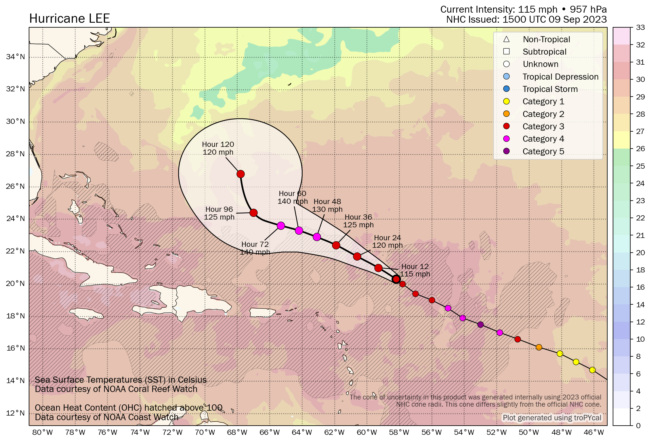
Hurricane Lee: 115 mph, moving WNW 12 mph
What’s changed since yesterday?
Lee has fluctuated back down to a category 3 hurricane, but there are some indications that Lee may be beginning another cycle of intensification today. Fluctuations up and down in intensity are expected over the next several days.
Lee’s intensity forecast
As noted, Lee has ebbed to a category 3 storm with 115 mph winds. It does seem as if it wants to begin another cycle of intensification, however, and the official NHC forecast brings it back up to a category 4 storm tomorrow or Monday. Lee is battling some wind shear right now, and it has taken on a rather ragged look, but per the most recent discussion from the Hurricane Center, it’s pretty evident that Lee still has plenty of punch. Reconnaissance flights were unable to get into the northeast eyewall of Lee this morning due to safety concerns around the thunderstorm activity in that part of the storm.

The shear is sort of a wild card with Lee right now. If it holds on more than forecast, Lee may sort of oscillate between category 2 and 3 intensity over the next few days. If the wind shear can relax enough, Lee would be capable of intensifying again back to category 4 or so. The NHC has taken this into account in their forecast, which shows some strengthening in the near-term, followed by a drop in intensity late.
Regardless of “what” Lee is, it will remain a potent storm over the next 5 to 7 days. Rip currents and rough surf will be a feature along the U.S. East Coast, Bermuda, the northern Caribbean islands, and the Bahamas. Eventually the rough surf will make it to Atlantic Canada as well.
Lee’s track forecast
Everything is in line with what has been expected through early next week, which is to say that Lee should comfortably avoid the Caribbean islands and avoid the Turks and Caicos Islands as well. While there is still a bit of uncertainty on exactly where Lee will turn northward, there is *strong* model agreement that it will occur before Lee gets close enough to bring direct impacts to the southeast Bahamas and Turks & Caicos Islands.
If you live in Florida, you remain in the clear from Lee and do not need to worry about this storm. Easier said than done, I know, but no reliable modeling shows Lee coming remotely close to making it that far west.
Farther up the East Coast, we have little to no additional clarity today on Lee’s future track. The good news I guess is that we do have confidence that Lee will turn northwest, north-northwest, north, and eventually north-northeast. But exactly how that happens remains to be seen and everyone from about Delmarva through Atlantic Canada, as well as Bermuda should be continuing to monitor Lee’s progress.
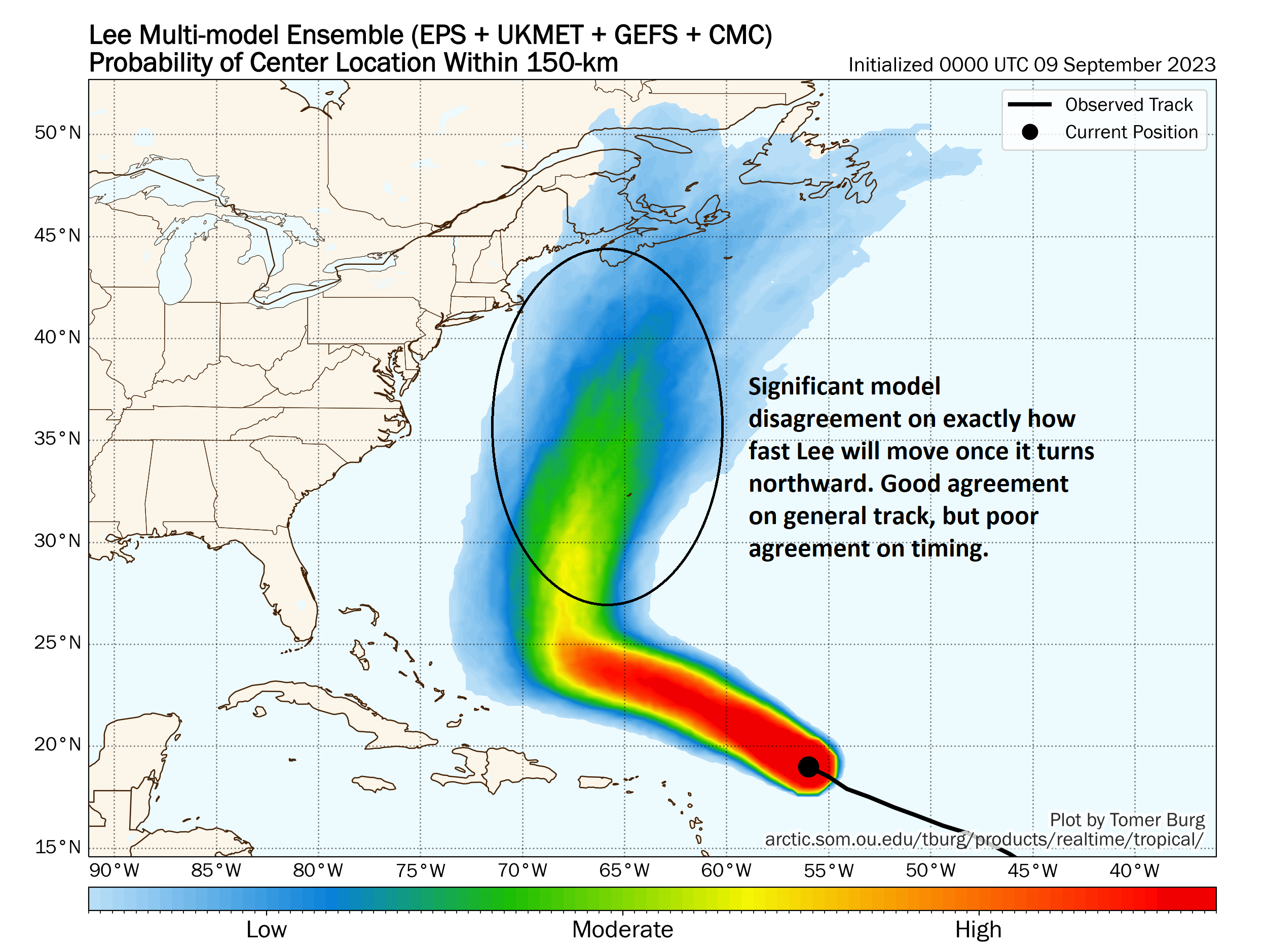
The map above shows track density, or roughly how many of the dozens of ensemble members agree on where Lee will go. Notice that the confidence is actually moderate that Lee will turn north and end up somewhere west of Bermuda. But from there, confidence drops.
One of the biggest problems right now is timing. We know Lee will slow down once it gets just east of 70° longitude. How fast does Lee come north? There is significant, massive model disagreement on timing of that speed once the turn gets made. For example, the European ensemble’s 51 members (not shown) have the center of Lee anywhere between just east of Cape Hatteras to north of Prince Edward Island next Saturday. That is roughly a 1,000 mile along-track spread. So we have high confidence in the turn, high confidence that it will go northward and pass just west of Bermuda but low confidence in how quickly it goes north, and that has implications on what to expect if you live in Halifax or Boston or Montauk.
I will say, it appears that the threat of direct impacts is fairly low right now from Long Island into the Mid-Atlantic. You should still monitor things, but the consensus view of modeling is that Lee will pass to the east of the areas hard hit by Sandy. New England? A slightly different story, as there is still a good deal of modeling bringing Lee close to Cape Cod or the islands. Still, most of it keeps it east, but it’s close enough. Maine and Nova Scotia into western portions of Newfoundland may be most at risk in the current environment. Again, the timing and intensity and exact track are impossible to nail down right now. But you can plainly see above that modeling is skewed right now toward the Maritime provinces.
We’ll continue to keep you posted.
Elsewhere: Margot and the MDR
Tropical Storm Margot continues to plod along in the open ocean.
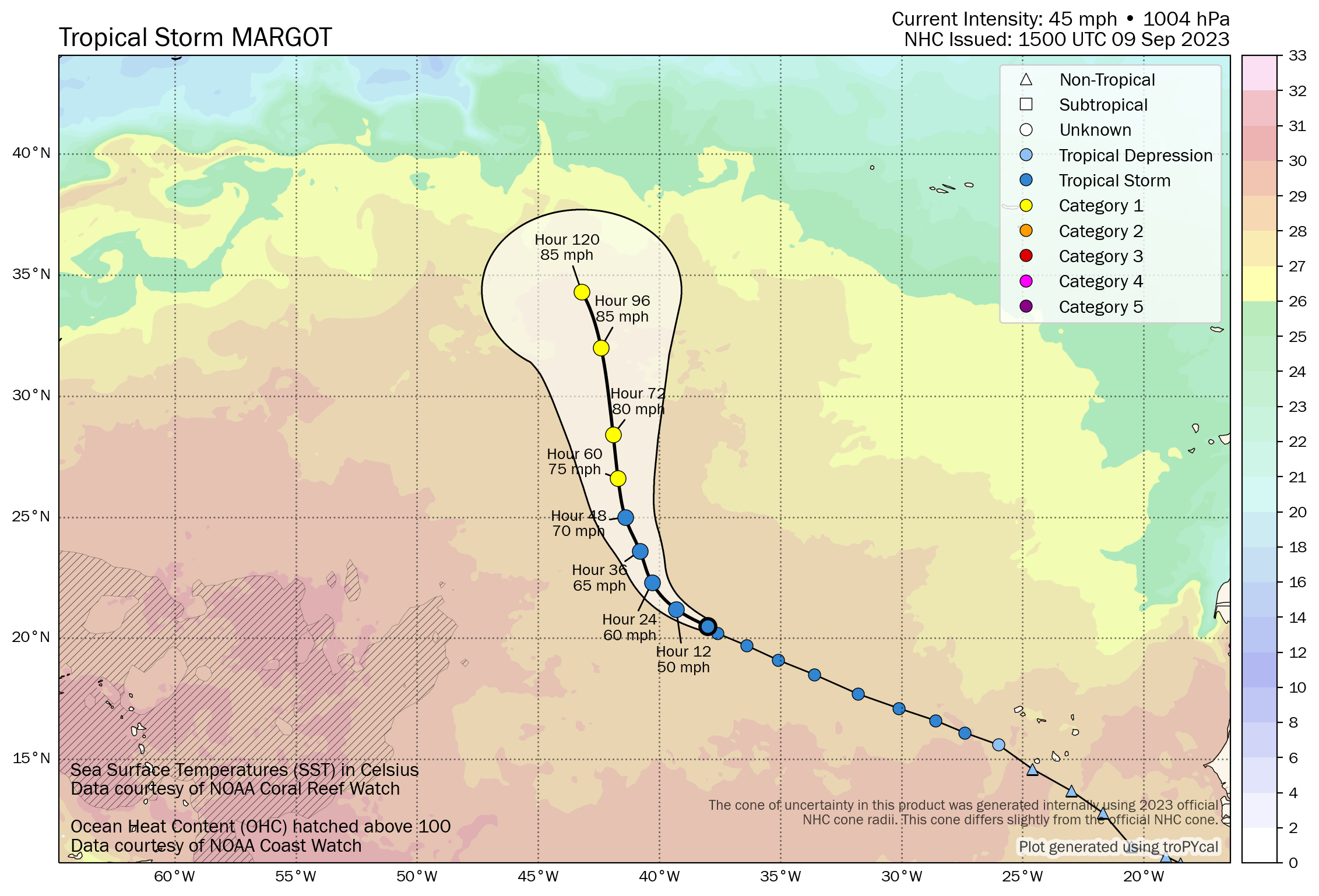
Margot has a good bit of warm water to work with over the next 3 days, so it should intensify close to hurricane strength before it approaches the cooler waters of the North Atlantic. Margot remains a bit of a wild card in terms of Lee’s track and we’ll likely be talking a little more about this storm later next week.
There continue to be some hints of another wave emerging off Africa and trying to make a go of it in the Atlantic Main Development Region (MDR) next week. As of now, there is not much else to say about that storm except that we are likely to see some outlier solutions on operational model guidance, so try not to read into that too much. Most reliable data says that this will be a slow developing system and may even struggle some.
The Eyewall has been a great addition to Space City Weather products. It really has a great balance of science and “plain speak” which makes it a valuable source of tropical weather information.
Thank you!
Again,thank y’all for up front and no BS updates. You guys are great,keep up the great work
👍👍👍👍👍
Thank you!
A very Atlantic and East Coast centric pattern for storms leaving Texas free and clear unless we get some front porch action.
It appears that way anyway.
Long range outlook for Gulf of Mexico is what?
Quiet as far as the eye can see right now.
Matt, your forecast allowed me to avoid buying travel insurance for the Jersey Shore. Truly “no hype” accurate reporting.
As a long time Houstonian currently living in New England, I appreciate the straightforward, no BS updates.