One-sentence summary
Hurricane Lee has rapidly intensified into a powerful category 5 storm, and while it will not threaten land for at least a week or so, it will stir up rough surf and rip currents from the Caribbean to the East Coast of the U.S. in coming days.
One-image summary
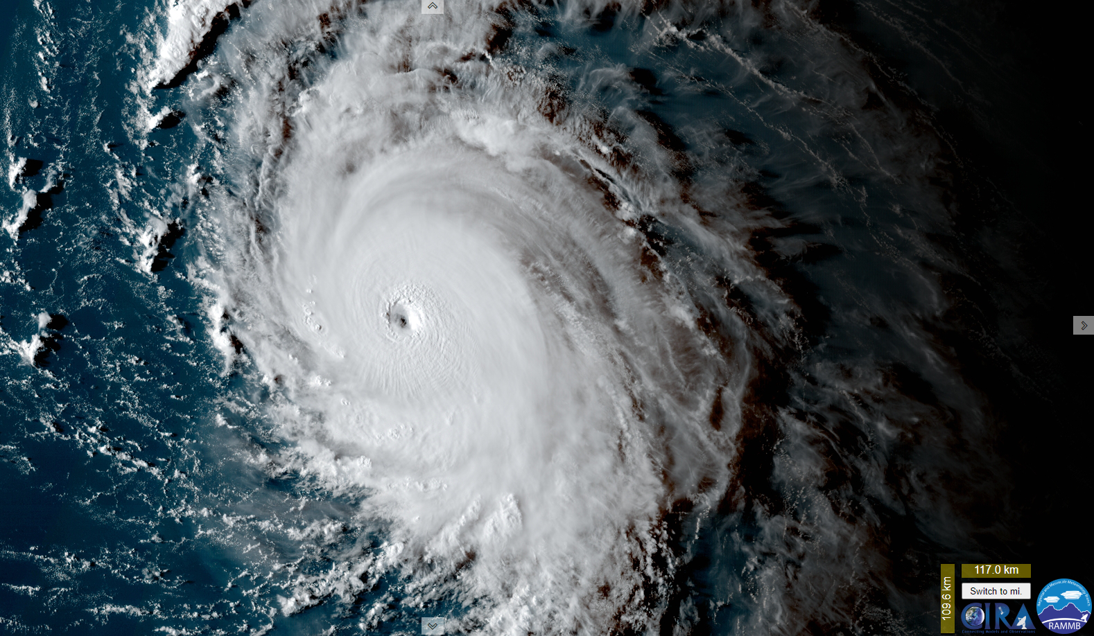
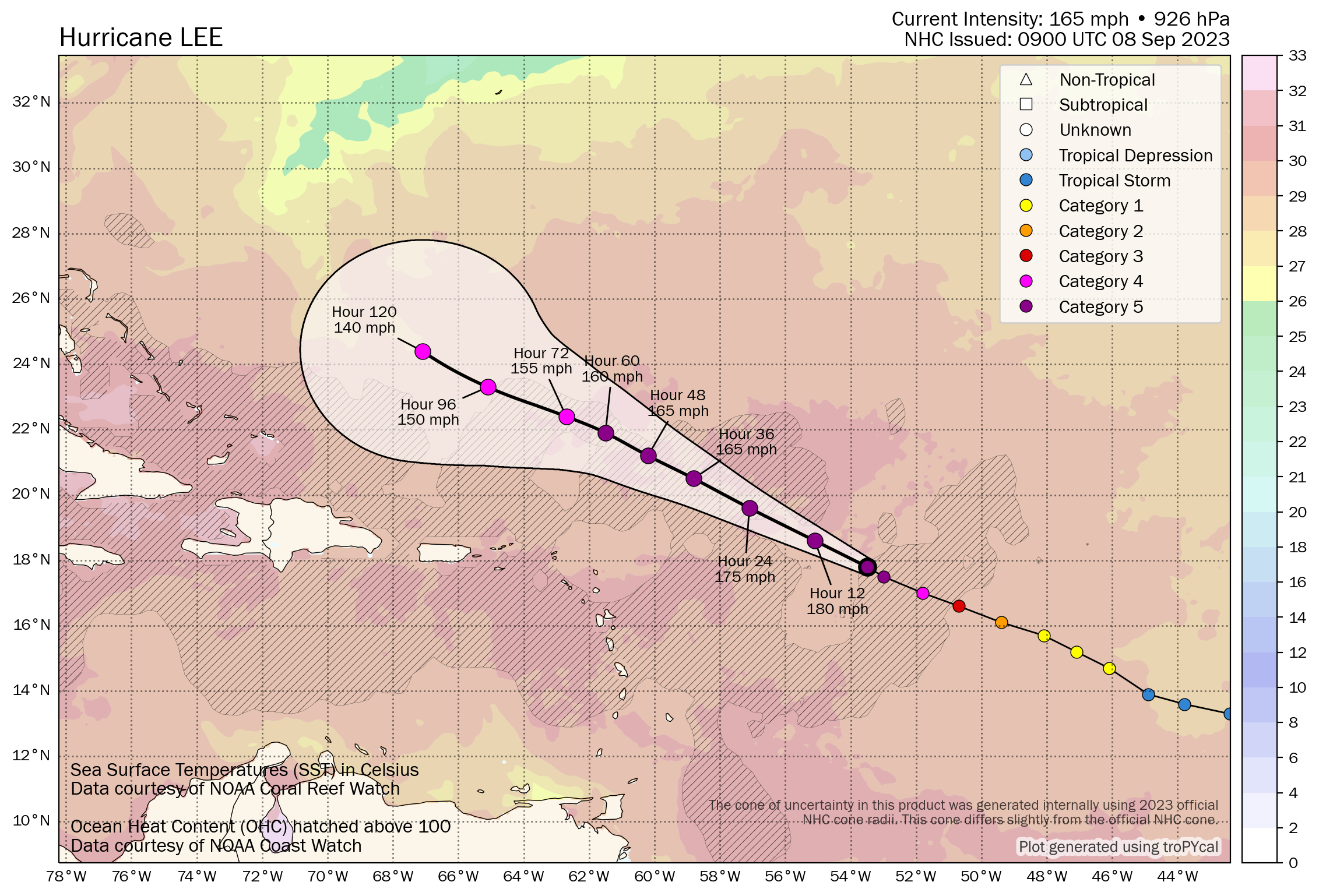
Hurricane Lee: 165 mph, moving WNW 14 mph
What’s changed since yesterday?
Lee went from an 80 mph storm yesterday to a 165 one today, an extraordinary rate of intensification that places it on the leaderboard in recent years. Lee is on the cusp of being one of the strongest Atlantic hurricanes on record.
Lee continues west-northwest, and while models continue to agree on an eventual northward turn, the timing, speed, and location of that turn will be important in determining the next steps next week.
Lee’s impacts through the weekend
Lee will not directly impact any land mass over the next few days. But it will make itself known. Large swells generated from Lee are expected in the northern Caribbean, including Puerto Rico and eventually Hispaniola, the Turks and Caicos Islands, and the Bahamas. Rough surf and very strong rip currents are expected, so if you live in these areas or are planning to swim in these areas this weekend or next week, please be very, very cautious.
Swells will build and begin to impact the U.S. East Coast, Bermuda, and eventually the Canadian Maritimes, probably building from south to north beginning around Sunday. Much of next week will feature rough surf and strong rip currents on the Eastern Seaboard.
Lee’s intensity forecast
We should be seeing peak Lee today. Normally, category 5 storms do not stay there. They become vulnerable to internal and some external forces that can cause them to fluctuate in intensity, sometimes considerably. Lee could Sisyphus its way along the intensity scale tonight through Sunday.
Beyond that, Lee is likely to drop back a notch, probably fluctuating between category 2 and 4 intensity next week as it turns the corner off the East Coast. Certainly still a powerful storm but not quite peak intensity. As Lee further gains latitude later next week, it should weaken further, but in compensation, it could expand in size or increase its forward speed some. Its impacts would still not be that of a category 5 in terms of wind, but it will be capable of causing problems should it make it to land or close to land.
Lee’s track forecast
We have little clarity on Lee’s track next week, except to say that it still is likely to miss to the east of Florida, Georgia, and South Carolina. As Lee advances forward, it will slow down. When Lee gets to a point somewhere just northeast of the Turks & Caicos Islands or southeast Bahamas, we will see it possibly slow to a crawl. This should occur Monday and Tuesday.
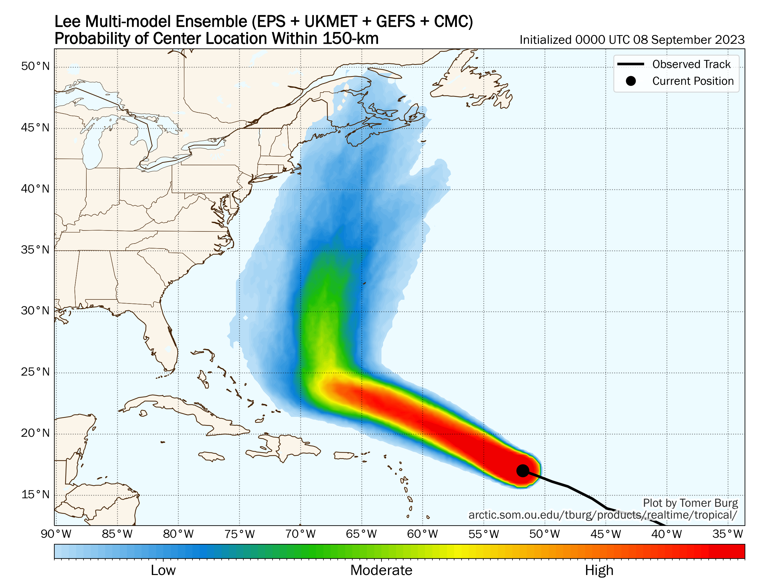
Lee will then turn hard to the north. Beyond that point, Lee will be fighting a battle with a trough (dip in the jet stream) over the Eastern U.S., high pressure to Lee’s east, likely-Hurricane Margot, and a fairly substantial area of high pressure that establishes over Newfoundland. You can see those features on the map below. Again, the placement and intensity of these features will determine if Lee goes toward New England, toward Nova Scotia, out to sea, or out to sea and toward Bermuda. But it is clear that any direct land impacts would probably not occur until the end of next week or even next weekend.
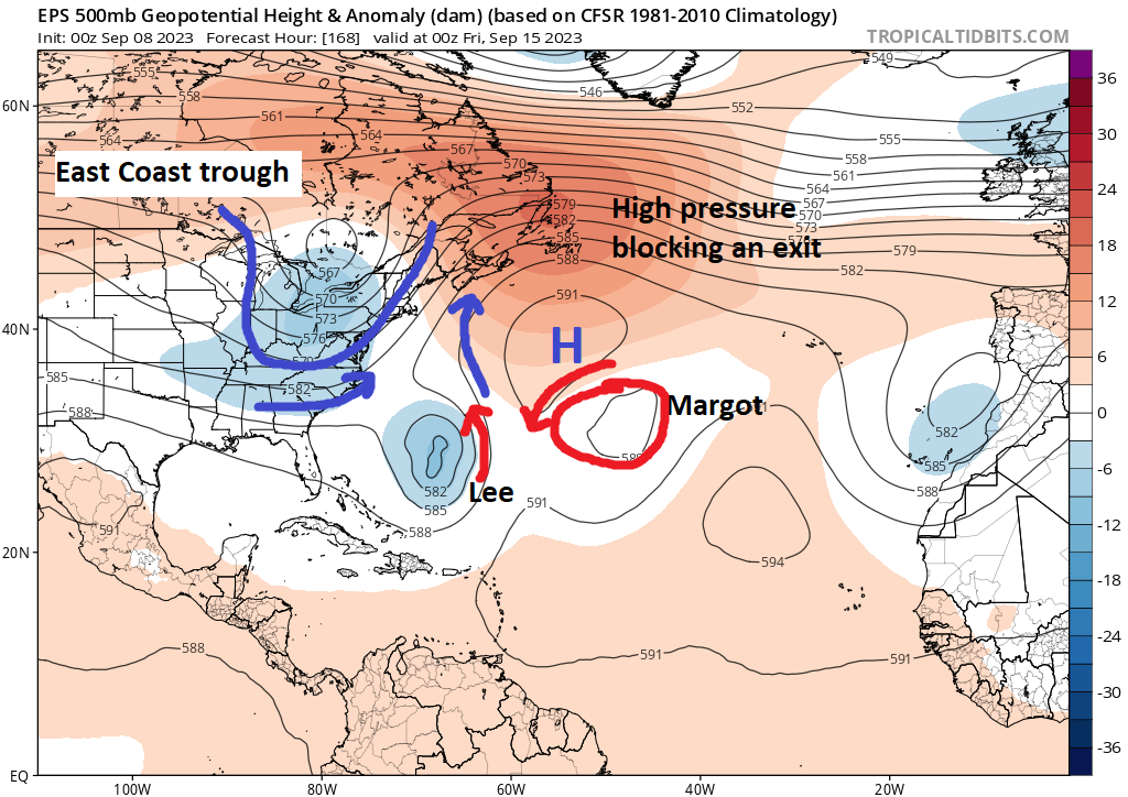
I’m curious about two things today. First, the ridge north of Bermuda extending up to Newfoundland may be a key to all this. It’s going to essentially narrow the escape route. If that were not there, we’d likely see Lee get picked up and ushered out to sea, no problem. With that exit door now cracked instead of wide open, I just get the sense that this is not going to exit easily.
Second, how will Margot and Lee interact? Last night’s operational European operational model showed an interesting scenario where the two systems come close to interacting with the Fujiwhara effect. In that scenario, Lee could theoretically be forced to go a bit to the east and Margot a bit to the west. There is a trivial but not impossible scenario where Lee gets directed away from land or a specific land point because of this.
More importantly, all of this underscores just how difficult predicting Lee’s end game will be for another few days at least. It’s a good time to review your hurricane plans if you live along the Mid-Atlantic or New England Coasts or in Canada to be safe, but we have a long, long way to go here.
We will keep you posted each day this weekend on forecast developments.
Margot makes a splash
Tropical Storm Margot formed yesterday in the far eastern Atlantic. It will not be a threat to land over the next week.
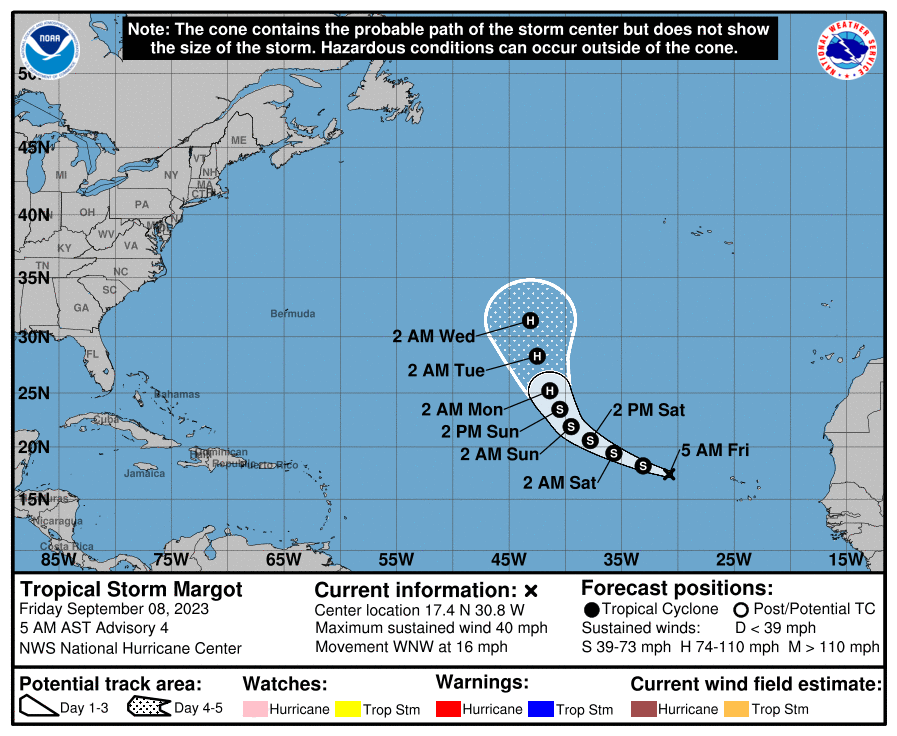
Margot is expected to become a hurricane, another feather in the cap of those who predicted an active season this year. As noted above, we’ll watch to see if it can’t have influence on Lee’s eventual track outcome late next week.
Anything else?
Nope. The basin, at this point looks as though it should quiet down a bit outside of Lee and Margot. No new systems are expected for most of next week, although some recent GFS and Euro ensemble runs are trying to spin up another Cape Verde system late in the week. Nothing else we need to fret over right now, however.
Good job, keep it up.
Spike
I agree, good, authoritative, rational review of nerve-rattling topic!
Agreed, agreed, agreed! Thank you for this.
Thanks to you both!
Didn’t we have a Fujiwhara effect, or an almost effect, within the last few years? Maybe southern GOM and Caribbean Sea? Thank you guys so much for The Eyewall. We moved away from Houston to west of San Antonio in the summer of 2022 and I dearly miss SCW. I finally stopped reading it daily about 6 months ago 😂. Keep up the good work!
Back in 2020, Hurricanes Laura and Marco got close enough in the GOM that all the weather folks were talking about Fujiwhara for a while. They ended up not actually interacting. Laura slammed into Louisiana as a Cat.4, but Marco petered out and did very little.
Thanks – I was pretty sure it was GOM.
I wish I could believe that the storm physics of Lee & Jova were anomalous, but I don’t.
Hard to believe 928 mb is a cat 5 storm……that pressure seems a bit high? Usually it takes getting below 92mb at least. Wilma which holds the record for the greatest rapid intensification was 882 mb and did 97 mb drop in 24 hrs. I think it was tropical storm to most intense storm in a day?
Yeah. Every storm has nuances. They all intensify differently and have different features so they never do the same things. Generally, storms need time to get that deep in terms of pressure. I don’t know that we’ve seen Lee peak yet in terms of low pressure. Wind is more a function of pressure gradient than the physical pressure of the center of the storm.
I have a trip to Florida planned Tuesday-Thursday next week. Should I cancel?
No. I would not cancel.
You appear to be asserting that Lee will not strike the mainland U.S. land anywhere south of New England. If so, then why does the NHC cone spread so far to the south–including a track in the cone far enough south that it is headed for the Bahamas through 8AM Wed? Why doesn’t the NHC tell the people in the Bahamas and in the U.S. south of New England not to worry, that Lee will miss them?
The cone actually does not go into the Bahamas. I explained the reasons why the South and Bahamas are more than likely clear of direct impacts in the post. As of this moment all reliable modeling turns Lee north before it gets close enough to the Bahamas to cause direct impacts.
Will Jova in the Pacific and Lee in the Atlantic affect the weather pattern over the mainland US?
There is some chance they could impact the overall jet stream. I think we may see a propensity for more high pressure near Greenland in the coming weeks. That could help cool down the South a bit. But that’s more speculative than anything.
“Sisyphus”? I’m trying to see how that equates. Sisyphus is an analogy for hopeless actions – like pushing a boulder up a hill only to have it roll back down and the pusher then having to start over, and over, and over…. – a hopeless activity.
I think the Greek mythological reference should have been to Scylla and Charybidis in Homer’s Odyssey.
I think in plain English, the suggestion intended might have been ‘hesitatingly’ or moderately thrusting’ ..or?
But you know, Bob, as I think of it, ‘Penelope’ might have been more apt. don’t you think? Every night she undid her weaving and started again the next day in order to forestall the sex maniacs until her main man should ever bother to return, maybe that is what Matt wanted to convey about Lee. 😉
I think he means that over the next few days Lee, could climb to peak intensity (Cat 5), then fall back to a lower intensity (Cat 3), only to build back to another peak (Cat 4), and then fall again (Cat 3), before ever making landfall.
So from Lee’s perspective, the analogy applies because it feels like every time it finally reaches that peak power level it falters and has to start building again from a lower level.
Correct.
Knocking on wood as I type this, but why is the boiling hot Gulf of Mexico so quiet?
Shear, for one. It’s going to be very high in the coming weeks, not uncommon during El Niño. Water temperatures are (thankfully) only one part of the equation when it comes to storms. If you have a hostile atmosphere, you can have supercharged warm water and it won’t make much difference. We’ve had that of late. Earlier in summer, high pressure basically “shielding” the Gulf helped too. But as we know, we saw with Idalia how fast things can change. So it’s great that it’s been quiet in much of the Gulf.
FWIW, on this date in 1900 a devastating hurricane made landfall on Galveston Island, killing 1,000’s – estimates of the fatalities ranged from 3 to 6 thousand. My maternal grandmother, a small child at the time, was a Galveston resident and storm survivor.