Just a quick note: We are aware of some email issues some of you are having where you get the post title and no other content. We’re investigating the reasons that may be causing this and hope to have a resolution soon. Sorry for any inconvenience!
One-sentence summary
Hurricane Lee should peak once again today or tomorrow before beginning a weakening trend but also a period that has it grow in physical size as it comes north, increasingly unlikely to turn out to sea.
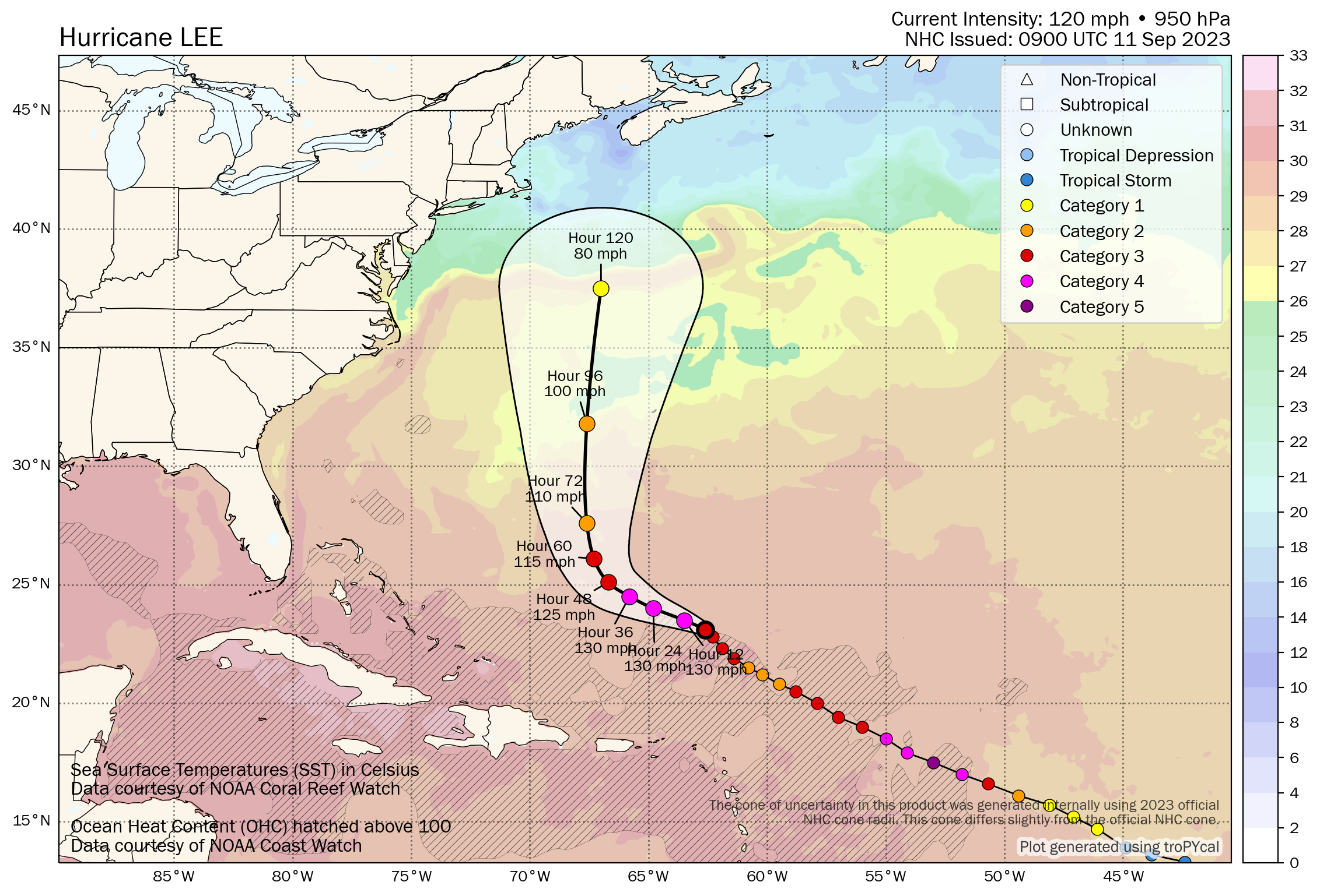
Hurricane Lee: 120 mph, moving NW at 7 mph
What’s changed since yesterday?
Lee has re-intensified to a Category 3 hurricane with winds of 120 mph. It is expected to peak once more in intensity today or tomorrow before beginning a gradual weakening trend as it encounters more shear and cooler water temperatures. Lee’s track forecast continues to flop around some, keeping eastern New England through Atlantic Canada on guard for potential direct impacts late this weekend.
Lee’s intensity forecast
Lee is by no means a perfectly healthy storm, but it has gotten some of its act together since yesterday.

Lee became a category 3 storm again yesterday, and it’s likely in the middle of a gradual intensification cycle that should peak today or tomorrow. After that, Lee begins to encounter cooler water and more wind shear from an approaching upper level trough in the jet stream which should allow for steady weakening.
It’s important to note that just because Lee is unlikely to be a major hurricane at high latitudes, it does not mean that Lee will not be a significant storm. Its wind field is likely to expand as it comes north. So it will compensate for weakening by growing in physical size. Folks potentially in the path of Lee should continue to watch it closely.
Lee’s track forecast
It’s becoming increasingly unlikely that Lee is going to turn out to sea. Over the next 2 or 3 days, Lee will track generally west-northwest or northwest, before turning northward. Lee will be steered around the western flank of weak high pressure in the Atlantic and toward a trough moving through New England.
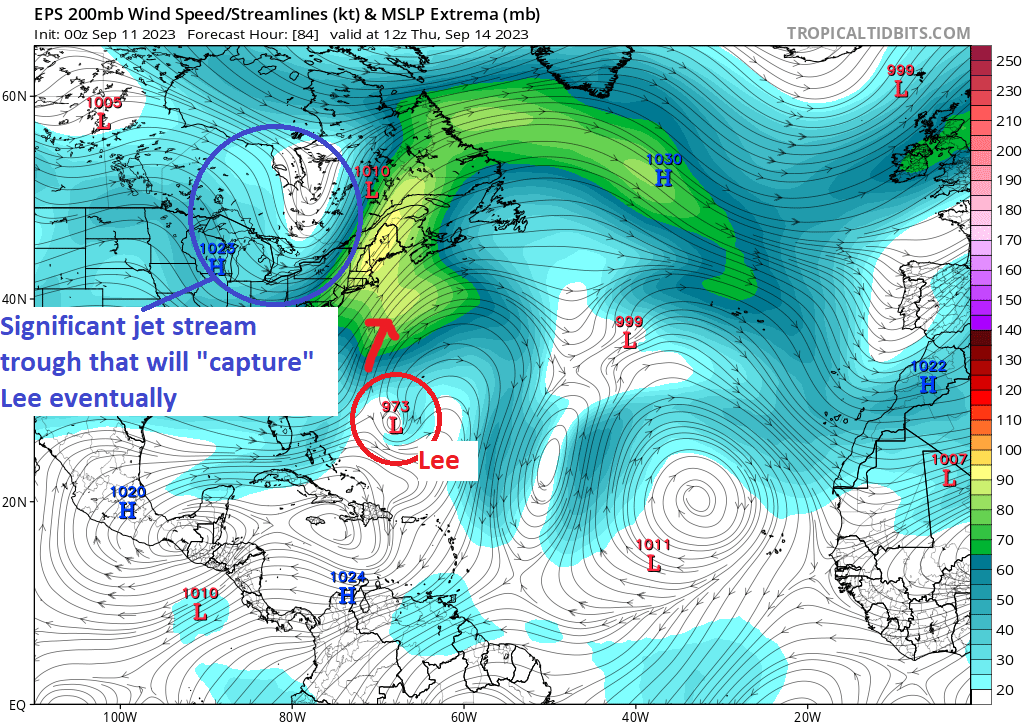
The trough is going to play an increasingly important role in Lee’s future, with the exact intensity of it this weekend up for some debate. That will determine if Lee is captured closer to New England or more toward Atlantic Canada. That may also determine how big, broad, and strong Lee’s wind field is when it gets there.
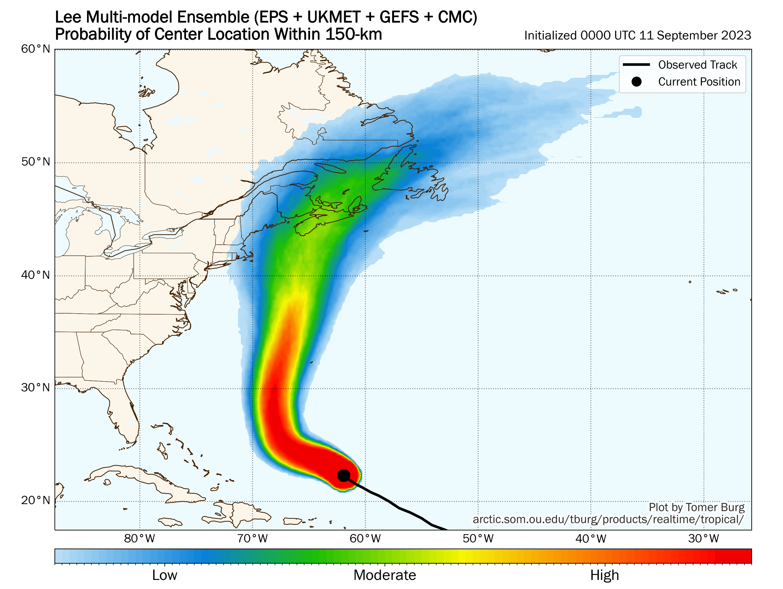
The bottom line at this point: Folks from eastern New England to Newfoundland should be closely monitoring Lee’s progress. Any direct impacts from Lee are likely to not arrive until Saturday if it tracks toward New England or early Sunday if it tracks toward Atlantic Canada.
Potential impacts through midweek
In the meantime, we have rough surf and rip currents that are expected to overspread most of the western Atlantic this week. This will impact most areas in the Bahamas, Turks and Caicos Islands and north facing shores of Hispaniola, Puerto Rico, and the Leeward Islands. Bermuda will also see this occur, but we’ll be watching to see there just how close the core gets to the island. For now, I would anticipate we’ll see Tropical Storm Watches hoisted for Bermuda by late tomorrow or Wednesday.
Elsewhere: Margot and what’s next?
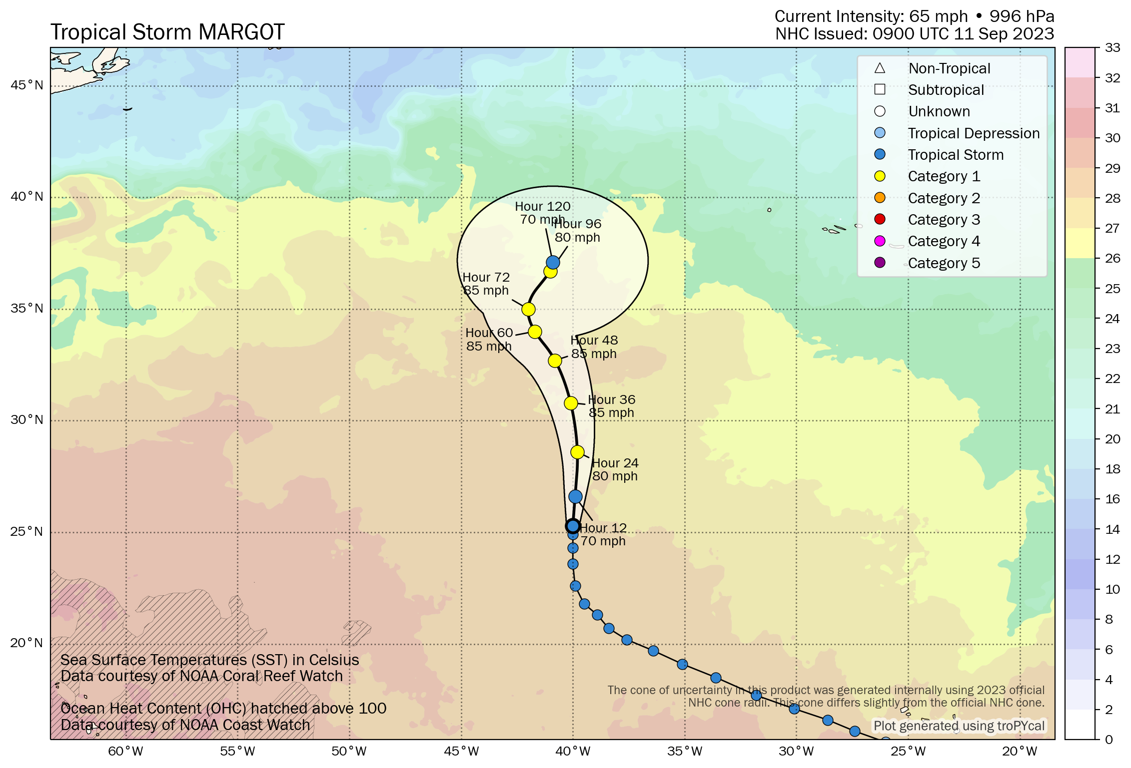
Tropical Storm Margot is likely to become a hurricane today as it moves generally due north. It will not impact land over the next 5-6 days, but it may get tied up in awkward steering currents in the open North Atlantic that could lead to it wandering about well into next week.
Off Africa, the next system seems most likely to follow (broadly) Lee’s track, which hopefully keeps it north of the Caribbean and eventually turns it out to sea. It will merge with Invest 97L. I’m not sure if the protocol will be to tag it as Invest 98L or keep the 97L label, but whatever the case it comes broadly west-northwest through the week, and the vast majority of model guidance keeps it north of the Caribbean.
Other than that, we see absolutely no signs of any Gulf or Caribbean activity through midweek next week, with wind shear mostly ripping in that part of the basin.
Fyi, I am one of those folks with the some email of just getting the post title. However, if you click on the title, you get the whole enchilada 😁
I signed up twice and have never gotten any email at all. Not in spam. I need to search for site to access. It’s ok, but email would be nice. This has become my main source for storms and keeping my sanity living in New Orleans…..
Hey Jay, I tried signing you up. See if you get a confirmation email in your inbox. Every so often there are weird things that happen and someone can’t get it into their inbox…it’s a little frustrating but, alas.
Your missing image issue isn’t specific to your site. I receive notifications of new posts from Wordpress bloggers via gmail, and some of those emails suddenly are arriving without images. If you’re connected to WP in any way, that could point to the source of the problem.
Matt, like Paul above, for the past several emails all that I’m receiving is the header. I have to double click the header and it that takes me to the “Eyewall” Web Page.
Any thoughts on potential aviation impacts? I have a trans-Atlantic flight through Newark, NJ on Saturday. Likelihood it changes flights vs just a few bumps/altered flightpath?
It’s too soon to say with any specificity and I never like to predict airline behavior, but there will likely be some sort of alteration in flight path or timing if you plan to fly Saturday or Sunday to Europe. My guess is that they’d go farther north and cut back east, but I have no idea what they actually can do in those scenarios.
How does the layman find wind shear forecasts for the Gulf of Mexico?
It’s not easy, but I recommend bookmarking this link which will at least give you an observed wind shear: https://tropic.ssec.wisc.edu/real-time/windmain.php?basin=atlantic&sat=wg8&prod=shr&zoom=&time= It’s a little disorienting at first, but once you find Florida, you can find the Gulf and everything else. Red is strong wind shear, yellow is moderate, and green is light. The more red & yellow the better if you don’t want storms.
Thanks so much