One-sentence summary
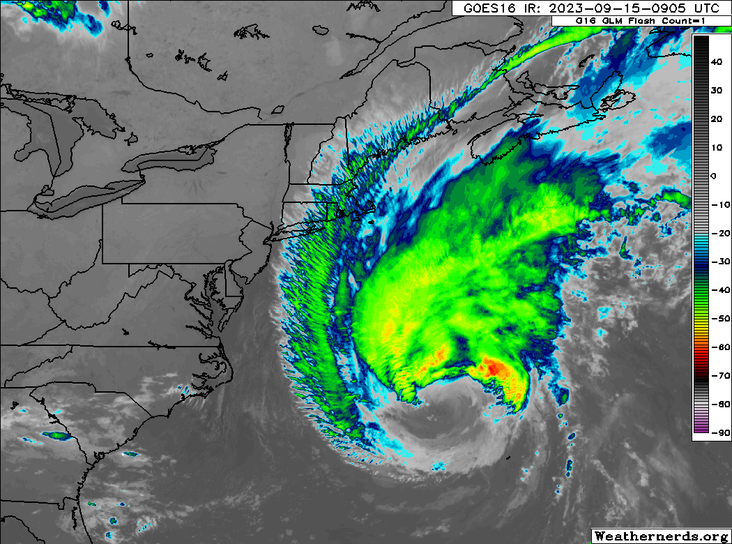
Hurricane Lee is en route to Atlantic Canada, a gigantic system, size-wise, and it will bring high-end tropical storm or hurricane impacts and surge to Atlantic Canada and Maine tomorrow.
Hurricane Lee: 85 mph, moving N 16 mph
What’s changed since Thursday evening?
Lee is beginning the process of transitioning to an extratropical system (more like a nor’easter than a hurricane), though the impacts will be the same regardless of designation.
Lee’s forecast impacts
Let’s move south to north today.
First, Bermuda should see improving conditions through the day today as Lee pulls away. Given Lee’s size, it would be likely to assume a breeze will continue out of the southwest, probably at tropical storm force at times, diminishing later and returning to calmer conditions overnight.
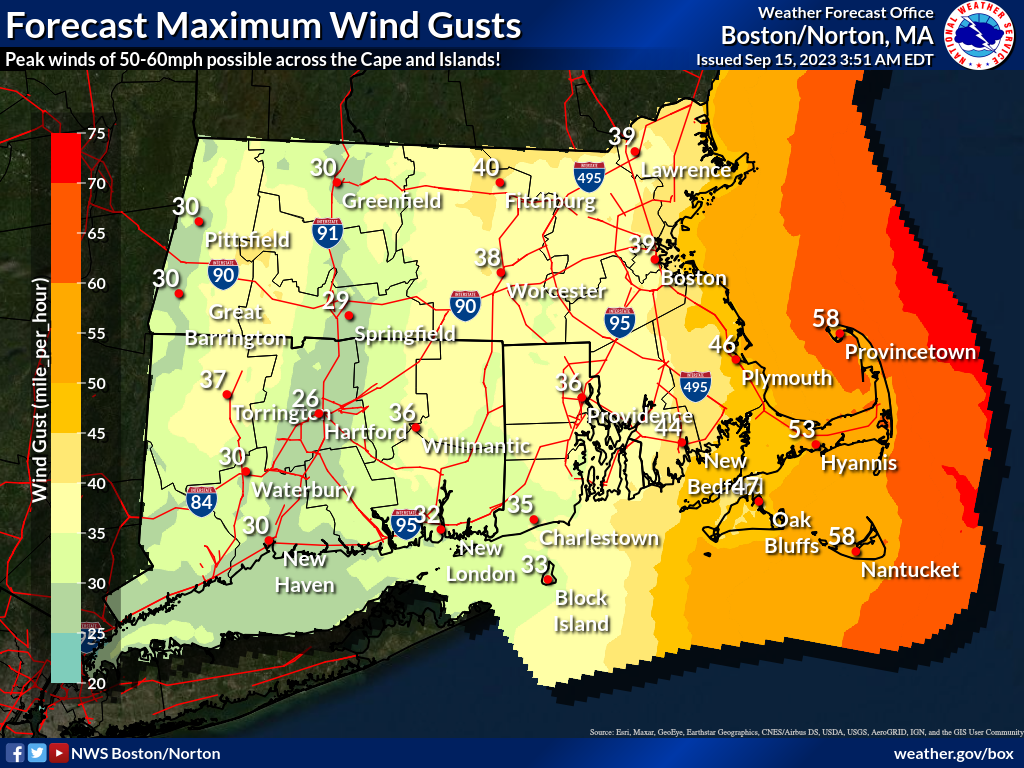
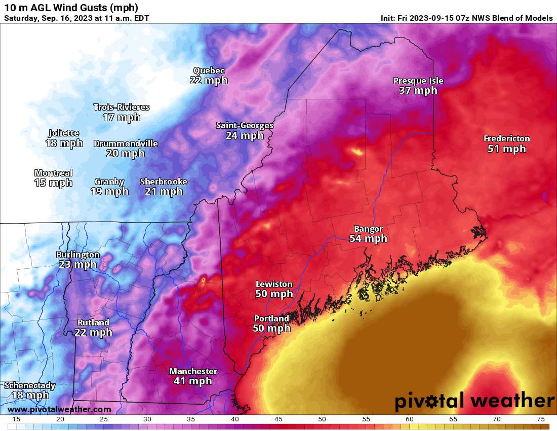
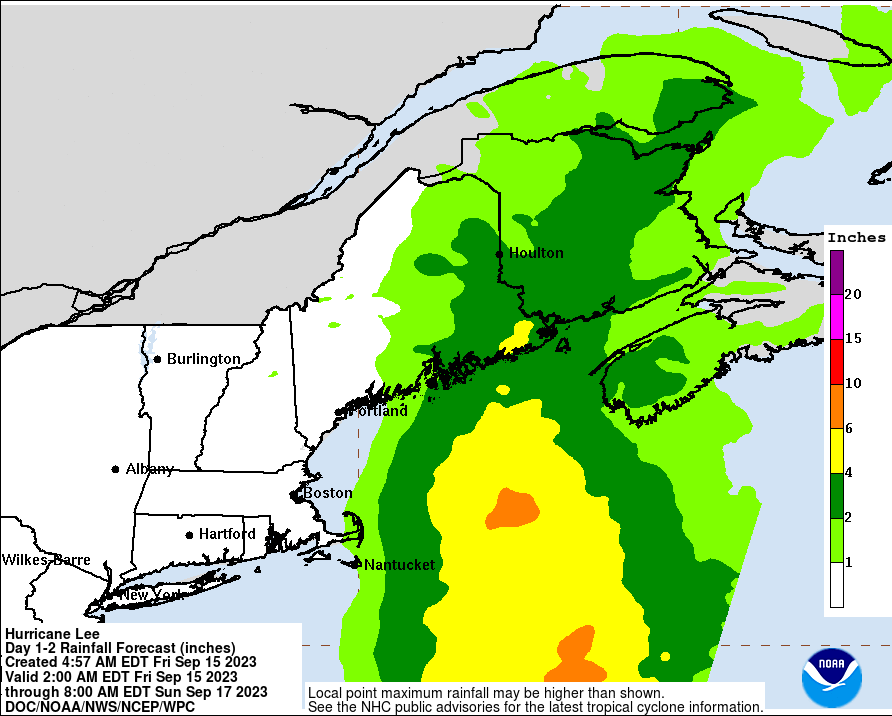
For Massachusetts, winds will pick up out of the north-northeast through the day, reaching near tropical storm force this evening with gusts over 50 mph possible on the coast. Wind should peak around daybreak Saturday and then drop off through the day out of the northwest. Look for periods of rain, as well tonight and early Saturday, perhaps adding up to an inch or so on the Cape and Nantucket, less in Boston and Martha’s Vineyard.
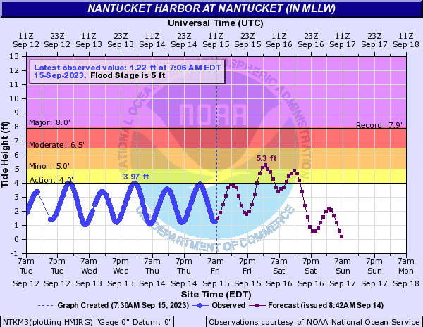
Storm surge of 1 to 3 feet will be possible for Nantucket, the Cape and up the Mass coast. Coastal flooding should be qualified mostly as “minor” in nature from this one.
In New Hampshire and southern Maine, winds should pick up this evening and peak Saturday morning through midday. Look for gusts of 45 to 55 mph or so on the coast, lower inland. Rain totals should be about an inch or so. Conditions will probably be a bit worse in southeast Massachusetts than in this area, due to the coastal geography. Surge will again be about 1 to 3 feet in this area, leading to minor coastal flooding.
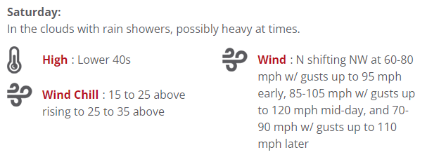
In the White Mountains, the Maine lakes, Highlands, Kennebec Valley, and up through Katahdin, you can expect elevation dependent outcomes. Low elevations should see mostly 35 to 45 mph wind gusts with periods of rain. Higher peaks will probably see 60 to 80 mph gusts, with Mt. Washington, NH probably checking in around 100 to 125 mph.
Rain totals will be in the 1 to 3 inch range, with lower-end amounts in New Hampshire and higher-end amounts in Maine.
For the Midcoast and Downeast Maine, you’ll likely see tropical storm conditions move in on Saturday morning and linger into Saturday night. Conditions should improve Sunday afternoon. The closer you get to Lubec and Eastport, the worse the conditions should be. Expect sustained winds near tropical storm force, around 40 mph or so, with gusts of 50 to 60 mph. Periods of heavy rain will lead to 2 or 3 inches in most places, with higher amounts as you get between Acadia and Eastport.
Surge of 1 to 3 feet (~1m) along the coast should lead to mostly minor flooding in Maine.
Moving into Canada, I don’t necessarily want to repeat everything I wrote yesterday, but I will repeat some because we took a deeper dive into Canadian impacts, and not a whole lot has changed since yesterday.
For coastal New Brunswick along the Bay of Fundy and western Nova Scotia along the Bay of Fundy, expect heavy rainfall, tropical storm conditions, and some very rough surf. I remain concerned about the Bay of Fundy and surge. There are some signs that the center may come in close to Saint John, NB which could allow a good bit of water to enter the bay. We will continue to watch this closely.
Digby into the Annapolis Valley in Nova Scotia saw a good bit of rain yesterday, and additional rain may front run things today. With another 1 to 3 inches (25 to 75 mm) or more, flash flooding may become an issue in parts of Nova Scotia.
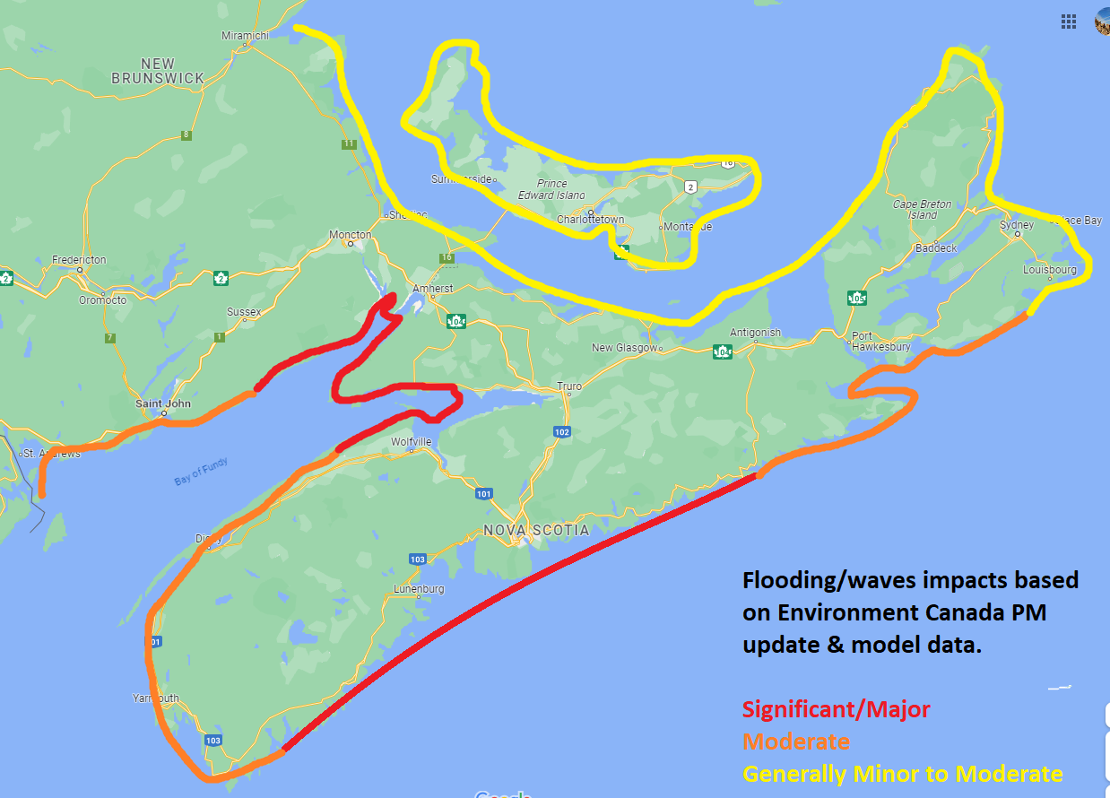
Significant surge impacts with big waves will be likely in Nova Scotia along the Atlantic coast. Additionally, borderline hurricane conditions will be possible here. Probably the worst land impacts from Lee will happen on the Atlantic coast of Nova Scotia.
Eastern Nova Scotia will probably see nor’easter type conditions with tropical storm force gusts possible.
Prince Edward Island could see some rough surf inbound off the Gulf of St. Lawrence. Meanwhile, some of that rough surf could impact Nova Scotia and New Brunswick off the Northumberland Strait. But coastal impacts overall will be minor to moderate, with periods of rain and gusty winds.
Heavy rain will fall across central and northern New Brunswick, as well as the Gaspe Region of Quebec. Totals of 1 to 3 inches (25 to 75mm) are likely here.
Overall, for most folks, Lee will be an inconvenience and a nuisance storm. People along the Downeast Maine coast, Bay of Fundy, southwestern half of Nova Scotia, and much of New Brunswick should be taking Lee seriously and preparing for perhaps some more significant impacts. Fingers crossed for a positive outcome.
Elsewhere: Margot and Future Nigel
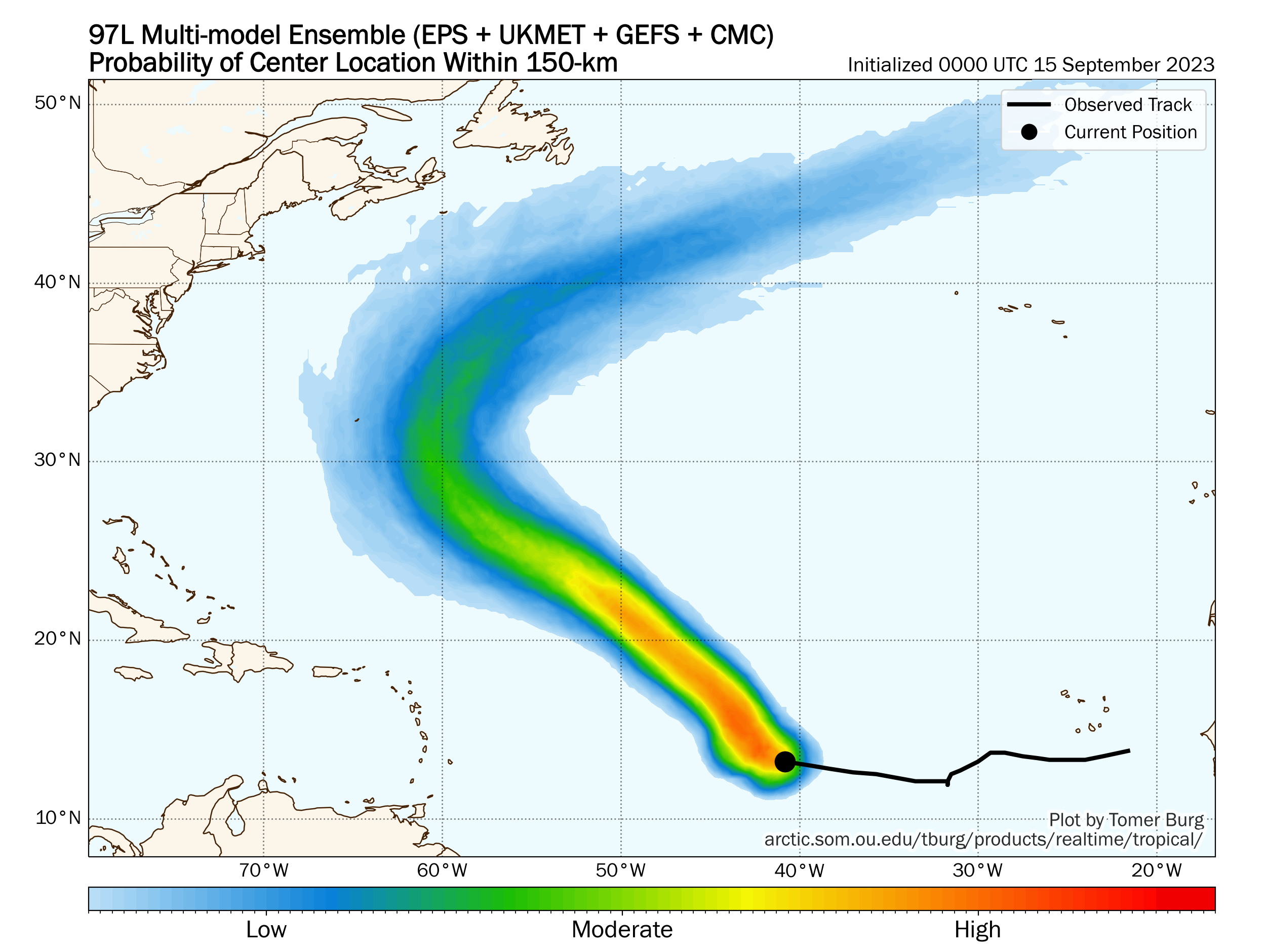
Margot remains a non-issue for us. Invest 97L is closer to developing this morning. The next name on the list is Nigel. This system is expected to avoid most land. However, it may be an item to watch for Bermuda eventually.
There may be yet another Cabo Verde system next week, which would likely follow Nigel out to sea. The Gulf remains quiet.
Just to slightly amplify the concerns surrounding the Bay of Fundy, there are worries that the Chignecto Isthmus could flood, which would “decouple” Nova Scotia from New Brunswick. The isthmus basically has the only railway and highway in and out of Nova Scotia from the rest of continental Canada.
Agree. It has been tough to get much detail on surge forecasts in that area. I’m hopeful we get something more from Environment Canada later today.
Great coverage, Matt 😊
*am sending wellness to everyone affected by Lee* 🌬 💚
sure am grateful the Gulf remains quiet 🍃
Great reports for those of us along the east coast. Thanx for helping me sleep better at night.
Jay
Melbourne, FL