One-sentence summary
We discuss that the system off the East Coast this weekend will produce some notable coastal impacts, particularly from heavy rain and tidal flooding, and today we will assess the players that will shape the next Atlantic system near the Cabo Verde Islands.
Awaiting the next round of Atlantic action
Cabo Verde wave
Over the weekend, I noted how Hurricane Lee was emblematic of hurricane season, a marathon. You need to pace yourself to make it to the finish without losing your mind. Discussion about Lee lasted over three weeks, and it feels like we’ve already been sort of discussing this next Atlantic wave for about a week, and it’s just now awaiting the invest designation. This one has been a bit of a head scratcher, and we’re not a ton closer to resolution today on what will come of this. Let’s talk about what we do know.
Sometimes it makes sense to look forward before looking backwards. In other words, as a forecaster, sometimes I want to see what a model’s outcomes are before I go back and assess why it has that outcome. This is especially true when two of our more reliable models show two relatively different outcomes.
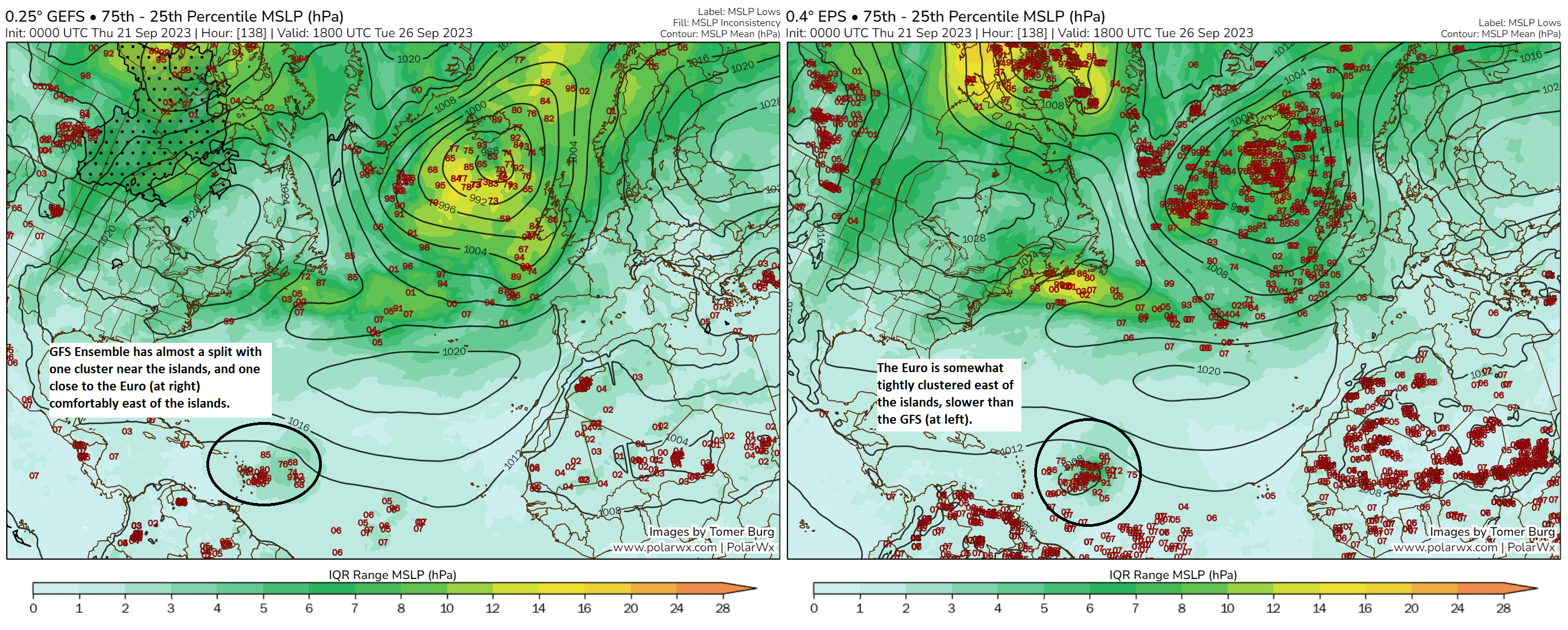
In the map above, you can see the forecast IQR, or interquartile range difference of sea level pressure in the Atlantic from the GFS ensemble (L) and the Euro ensemble (R). Explain this to you like you’re three years old? You got it. You have operational models, which are the ones that are deterministic; one run, one solution. Then you have the ensemble models which are the ones that run the model roughly 30 (GFS) to 50 (Euro) different times with tweaks each time to produce a range of outcomes. The maps above show you what the ensemble model outcomes say for sea level pressure of the 75th percentile minus the 25th percentile. In other words, how spread out are the outcomes within the majority of ensemble solutions? Or are they spread out at all? This will illustrate key differences and/or areas of higher confidence.
The European model is fairly tightly clustered east or northeast of the islands next Tuesday afternoon with the tropical wave, or whatever it is at that point. The GFS at left is slightly less tightly clustered, more spread out, and also faster, with a couple members even almost in the Caribbean next Tuesday. Interestingly, the IQR differences are not substantially higher on the GFS than the Euro, which may be a bit of a red flag for the GFS. But we’ll note that in our back pocket and operate under the idea that there are noteworthy differences.
So, we look at this and say, “Ok…the GFS is quicker and potentially near the islands, while the Euro is slower. Why the difference?”
So we’ll next look up, about 20,000 feet at the 500 millibar level to get a sense of what is steering the wave.
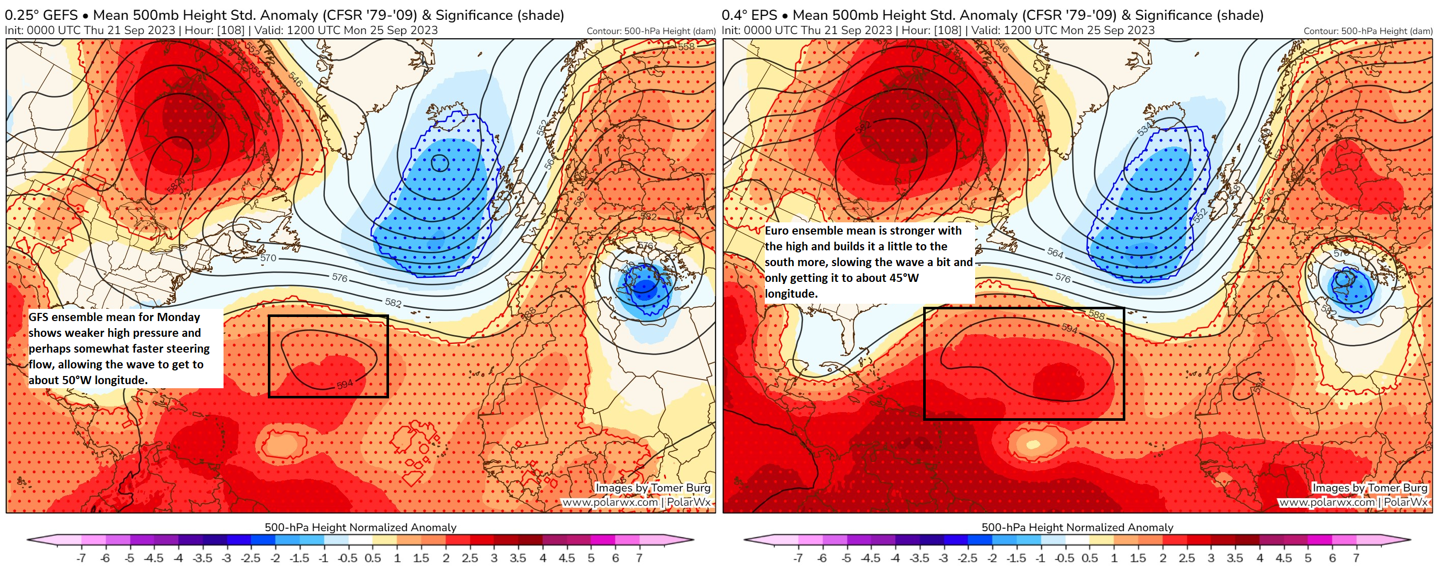
If we look at the forecast at 500 mb next Monday morning, we see the Euro and the GFS differ in terms of location and size of the high pressure system in the central Atlantic. The Euro is stronger and maybe actually holding the system up a bit. But the high pressure center moves out of the way, and an exit door into the open Atlantic awaits. Thus, the risk of the system making it into the Caribbean on the Euro is low.
But if you look at the GFS, the high is weaker, and a hair farther north, which probably allows the system to move a little faster, and it gets to the islands in some ensemble member cases before it can curve out to sea.
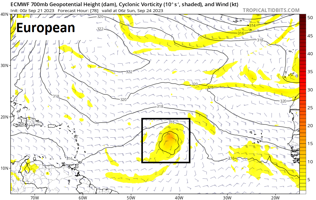
We can take this a step further to see which model develops the system faster. The GFS tends to be quicker to the punch than the Euro (forecast for Sunday morning shown here)
So what does all this tell us? The GFS is quicker to organize the wave, moves it faster west, and by the time the escape route north opens, the system may be bearing down on the islands. The Euro is slower, organizes the wave slower, and when the escape route opens, it’s still probably several hundred miles east of the islands and likely to hook northwest or north. Those are fundamental differences hinging on how the high develops and how the wave develops and interacts with other things surrounding it, questions we cannot adequately answer yet. But at least we have a cheat sheet of sorts now that we can apply to this wave. And we should know in a couple days if the islands are seriously at risk or if the northward solution is more likely. Stay tuned.
East Coast subtropical sloppiness
We continue to see a good chance that a surface low is going to develop well off the coast of Florida or Georgia tomorrow or Saturday. Look for that to wobble generally north up the coast and either into the Outer Banks or just ride up the East Coast toward Delmarva or the Jersey Shore as a subtropical storm or strong nor’easter.
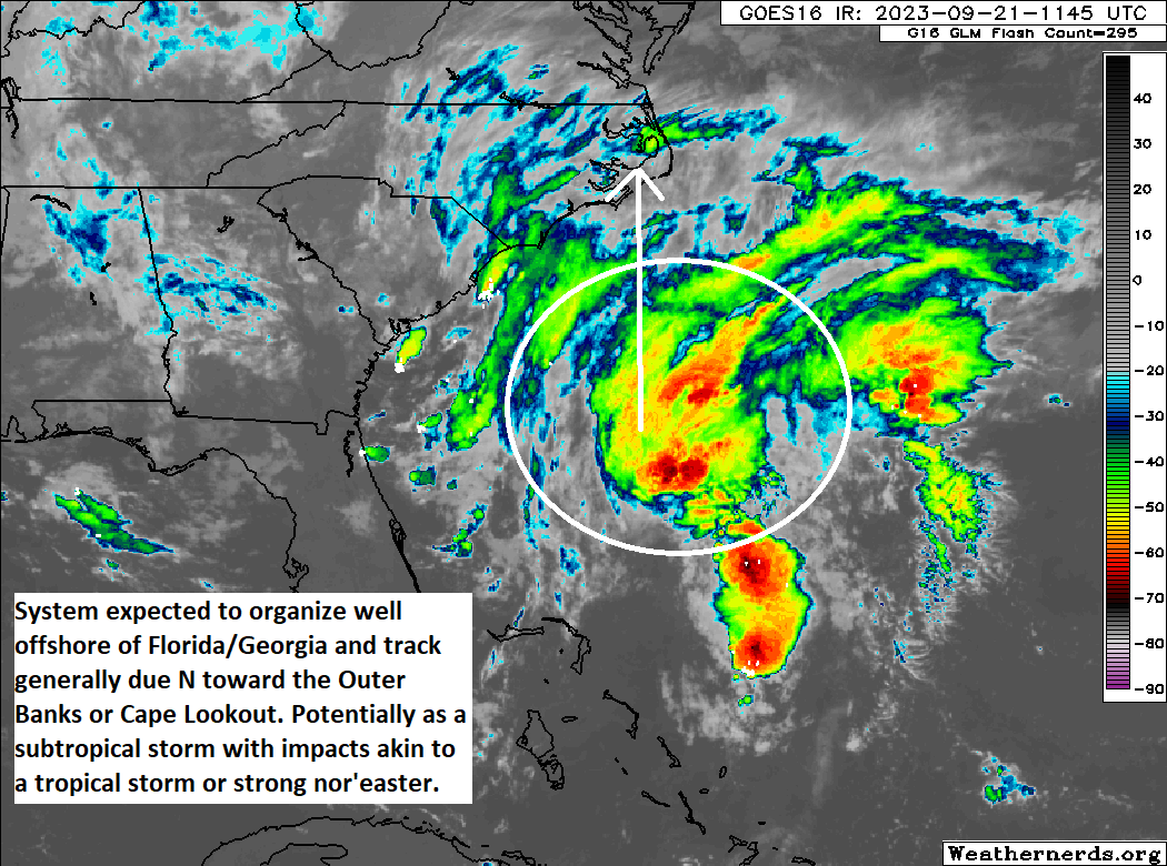
A subtropical designation just has to do with how the storm forms, and it has no bearing on the impacts. What will those impacts be? Well from the upper coast of South Carolina into most of North Carolina, coastal Virginia, Delmarva, and the Jersey Shore, we can expect rough surf, gusty northeast winds, moderate to locally major tidal flooding, beach erosion, and rip tides, in addition to heavy rain. This may be a step above nuisance status in some places now, akin to a rather strong nor’easter.
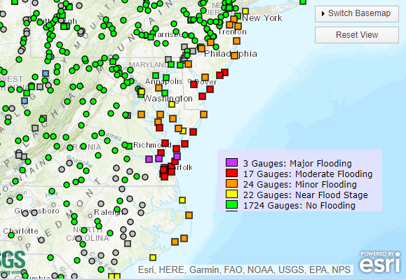
We are looking for a wide swath of 2 to 5 inches of rain on the Coastal Plain from Myrtle Beach through Long Island. This may cause flooding, particularly in lower-lying and urban areas. Coastal communities may see high tides exacerbated because of heavy rain, so this could slow the drainage process for a tide cycle or two this weekend.
We will be keeping you posted on the East Coast storm, as well as the progress in the forecast of the Atlantic system through the weekend.
This 3 year old (okay make that 3 plus 70) appreciates the simple explanation for before my coffee and the details for later.
You’ve been hanging out with some brainy three-year-olds. 😄
Seriously though, thanks for the always awesome content!
…I think I got it…we don’t have to evacuate Clear Lake yet…
Do you go back and look at the models past history to see which had it right so far? Is that even a predictor? For example, which model had the wave where it is now?
Oh it’s absolutely something to consider. You try to play the hot hand, while being cognizant that it may change at some point quickly.
Is the Atlantic wave a candidate for the Gulf of Mexico? From my knothole, getting to the islands basically means heading towards the Gulf. Thoughts?
No, it is very unlikely. I have been watching the model trends for the last few days for this system and the GFS has been only one that has the system entering the Caribbean. The GFS path has been trending northwards and today the model shows a path along the northern islands and Puerto Rico, not entering the Caribbean at all before turning due north. I expect the models will converge on a path for the system north and east of the islands before heading north into the Atlantic. Have a look at Mike’s weather page and Windy.com .
I never say never, but there is no reason to think this will make it the Gulf. Even if it gets into the Caribbean, it will likely turn north, and trends in modeling since this morning only reinforce that idea. So no worries for the Gulf.
Excellent and thorough explanation! Next time can you comment a bit more about the “escape” north and the confidence in that mechanism? Thank you!!