One-sentence summary
Potential Tropical Cyclone 16 (which will likely take the name Ophelia later today) will deliver tropical storm impacts to a broad swath of the Mid-Atlantic coast between the Jersey Shore and North Carolina, with heavy rain, gusty wind, surge and tidal flooding all likely regardless of naming or classification.
Potential Tropical Cyclone 16 (likely to become Ophelia)
Here are the key points on what we’ll refer to as PTC 16:
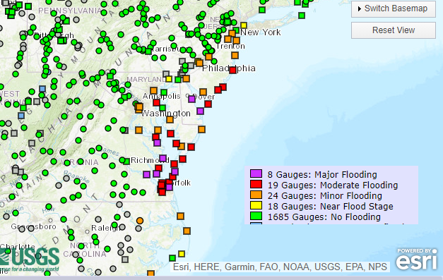
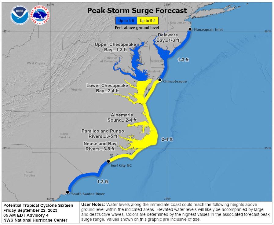
- Tidal flooding will be a serious issue for portions of the Lower Chesapeake and Delaware Bays, as well as along the coast between the Outer Banks and Jersey Shore. Locally major tidal flooding is expected from Delaware south to the Virginia Tidewater.
- Tropical Storm Warnings are posted between Cape Dear, NC and Fenwick Island, DE, including Albermarle & Pamlico Sounds and much of the Chespeake Bay roughly south of Easton, MD. Storm Surge Warnings are posted from Duck, NC through Chincoteague, VA, the Lower Chesapeake Bay, the Neuse & Pamlico Rivers in North Carolina, as well as portions of the sounds. Storm Surge Watches cover additional ground beyond there.
- PTC 16 will have a broad wind field, meaning a wide swath of 30 to 50 mph winds should be expected from the Carolinas through Long Island. The strongest wind will likely be confined to a small area near the center, which should come ashore between Cape Hatteras and Cape Fear in North Carolina.
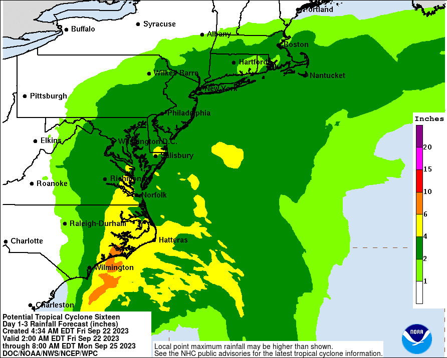
- Widespread moderate to heavy rain is expected between North Carolina and Southern New England with flash flooding potential highest in coastal North Carolina near the center of PTC 16.
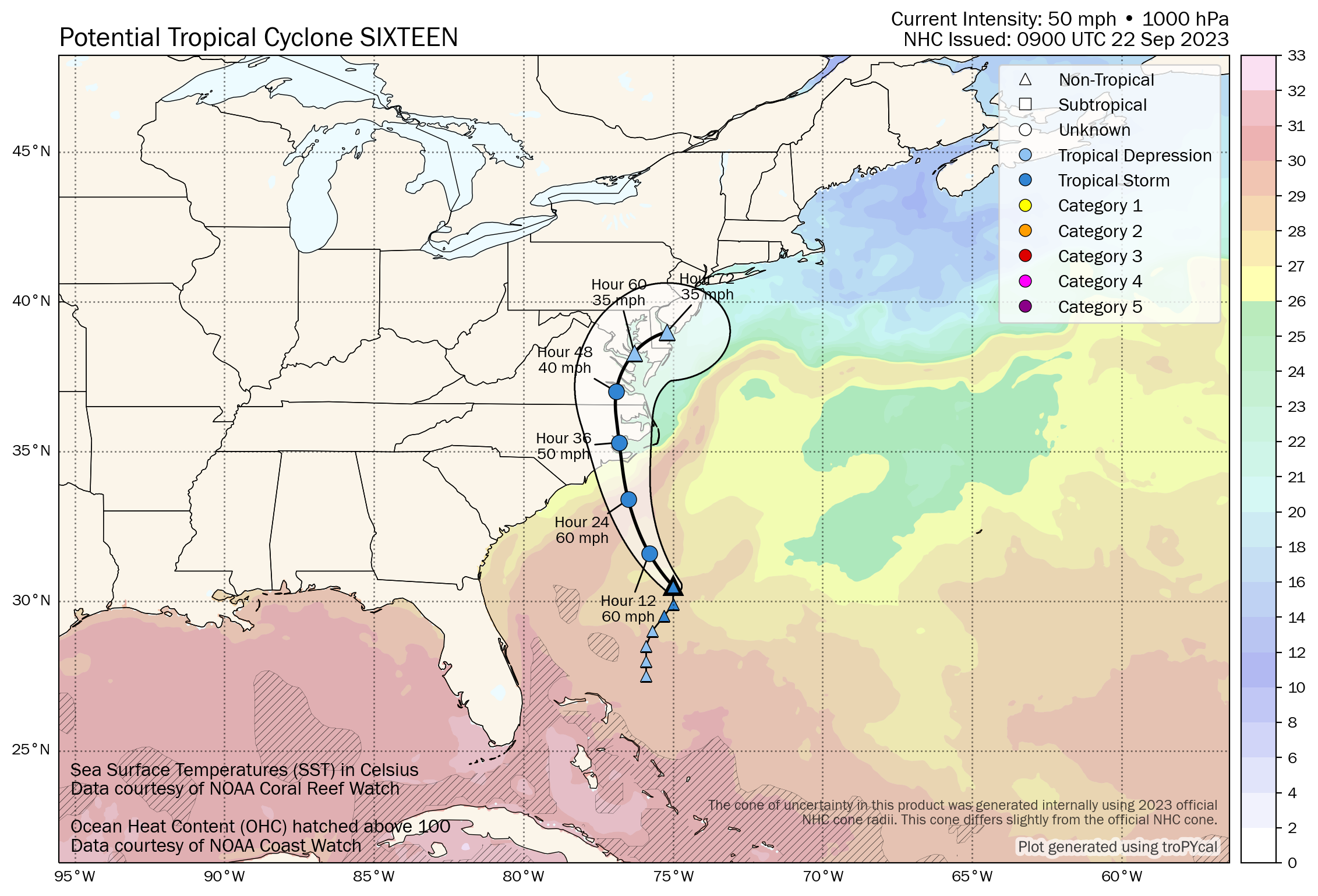
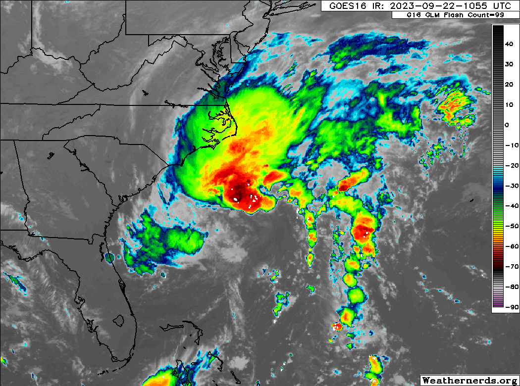
Potential Tropical Cyclone 16 is gradually organizing this morning off the coast. Despite having maximum sustained winds of 50 mph, it is still considered a “potential tropical cyclone” because it has not yet shed the technicalities (ie: fronts) that make it a non-tropical entity. For all intents and purposes this is already a equivalent to a tropical storm and should be prepared for as such. The NHC says that this will likely take on a subtropical or tropical tag once the frontal boundaries are shed, meaning it would become Ophelia.
Let’s walk through the expected impacts from PTC 16.
Coastal impacts
In my view, this is the most important aspect of this storm, and it’s the one that may cause the most problems. Current tidal forecasts show a significant number of stations in the Mid-Atlantic expecting moderate or major tidal flooding from the storm this weekend.
Let’s pick out a couple gauges to talk about real quick.
We’ll start in Norfolk, VA which is expected to see moderate tidal flooding, with a couple gauges nearby pinging major flooding in their forecasts.
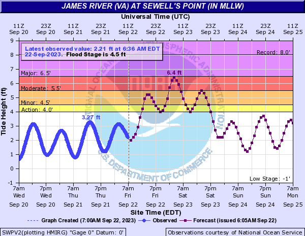
For the James River at Sewell’s Point, the 6.4 feet forecast tomorrow morning would be the highest tidal reading in Norfolk since Hurricane Joaquin in 2015. Historically, tides at these levels are likely to inundate portions of the waterfront in Norfolk.
For Lewes, DE on the Delaware Bay, this storm will likely produce the highest tides since January 2016 (the blizzard that was dubbed by The Weather Channel as “Jonas.”). Although Lewes will fall a solid foot or more shy of the record, this will still be borderline major flooding for the Delaware Beaches.
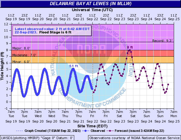
Flood levels of this nature will tend to cause mostly roadway flooding for Sussex County, DE but some structural damage is possible, particularly if tides come in higher than forecast.
Storm surge flooding is likely into North Carolina as well, in the Storm Surge Warning area.
In addition, we are expecting waves of 10 to 15 feet just offshore. The combination of high tides and rough surf will likely lead to beach erosion issues up and down the East Coast. I imagine some beachfronts are a bit more vulnerable after dealing with rough surf from Franklin, Idalia, and Lee already this summer, so erosion issues will get a bit worse.
Wind
PTC 16 is expected to top out near 60 mph winds as it comes ashore this weekend. However, over a rather broad area, we should expect 30 to 40 mph winds, with gusts over 40 to 50 mph, basically from Myrtle Beach, SC to Montauk, NY. A smaller area near the center should see the 60 mph winds on the coast of North Carolina, should the system develop as expected.
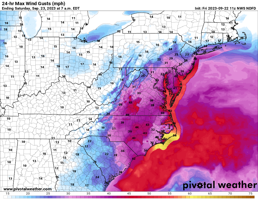
These winds will be capable of doing mostly minor damage, though scattered to numerous power outages are absolutely possible.
Rainfall
Total rain will be generally 2 to 5 inches, with isolated higher amounts up and down the coastal plain, extending inland in spots, particularly in Virginia and southeast Pennsylvania. Obviously this could cause flash flooding in spots. I would especially be aware of this rain on the coast, particularly in developed, more urbanized areas (Virginia Tidewater, Ocean City, MD, etc.) where the heavy rain could exacerbate tidal flooding by slowing how quickly it recedes at low tide. Some more considerable flash flooding risk probably exists near the center of this storm for Surf City to New Bern to Cape Lookout.
The bottom line is that this will be a notable storm on the East Coast with widespread impacts that will be disruptive and locally damaging.
Deep Atlantic wave (Invest 90L): Out to sea?
Yesterday, the Cabo Verde wave we’ve been watching was tagged as Invest 90L. We are slowly honing in on a compromise between the GFS and Euro solutions that I laid out in yesterday’s post.
We will watch trends today and tomorrow, but at this point, the odds will heavily favor a track that probably constitutes a “near miss” for the islands. It still needs to be monitored for obvious reasons, but the trends over the last 24 hours have been mostly positive for Puerto Rico and the islands. In this scenario if the system makes it into those areas, it would almost certainly be a weaker system.
Elsewhere, there is nothing of note out in fantasyland. For our Gulf of Mexico readers, yes, it still looks quiet.
Once again, a thorough and excellent synopsis of these two “tropical” systems. Forwarding this to my friends in Hampton, VA. Watching from the FL Panhandle and hoping for no Gulf mischief!
Have several friends traveling the East Coast, one by sailboat, they are livesboards in the Carolina’s on the coast, he said last night was experiencing 49-50 mph but everything is good, other one is a traving missionary he lives out of a tent on top of his jeep. He is in Maryland and sent pictures, he was unable to sleep in the tent so he slept in the Jeep, best he could, said the wind and rain was tough, but manageable.
Hi Matt. I love following your updates. We’re currently in Orlando and boarding a 3 hr flight tomorrow around 5pm back to RI. Do you think we should postpone our trip home?
Thanks!
I would not postpone anything, but I would be prepared for a potential delay on the trip…just to be safe!
Thanks Matt!
A look at history: One of the most deadly hurricanes to ever strike New England occurred on September 21, 1938. At least 700 dead. Massive property destruction. The National Weather Service gives the storm its own page. https://www.weather.gov/okx/1938HurricaneHome