One-sentence summary
A complex interaction between Philippe and Invest 91L enhances a bit of uncertainty in the Atlantic next week as it relates to the islands, though most outcomes still favor minimal impacts in Puerto Rico, the Virgin Islands, and Lesser Antilles.
Happening Now: Philippe and 91L (future Rina?) and where will they go?
Looking at satellite this morning, the Atlantic is just jammed up with Tropical Storm Philippe and Invest 91L back to back. Personal space anyone?
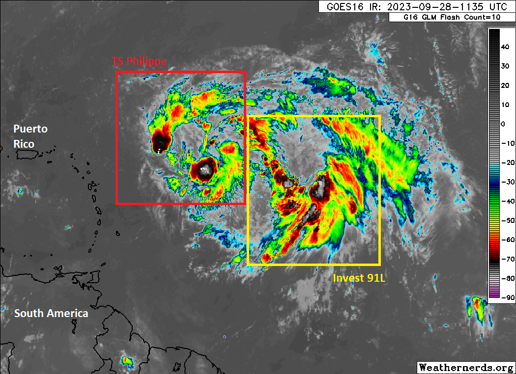
Anyway, this is actually important context to start today’s discussion with because the future and the future of any impacts will be somewhat contingent on which of these two becomes the dominant system in the Atlantic. On one side you have the GFS model, which has tended to overdo Philippe’s actual intensity, meaning that it has tended to slow it, park it as 91L interacts with it, and then take it north into the open ocean as a hurricane. The Euro essentially kills off Philippe and then sheds its remnants in the islands with some rain, while 91L tracks west as a weak system before turning north and strengthening.
Interestingly, the setup here is one that seems to keep in play a Fujiwhara interaction between the two systems. What is that? Basically, the two systems would track close enough to one another to impact each other’s track. In this case Philippe would likely slow, stall, or get pushed to the south since it’s ahead of 91L, and 91L would basically slingshot over the top of Philippe either west or northwest and out to sea. The GFS operational model shows this quite well.
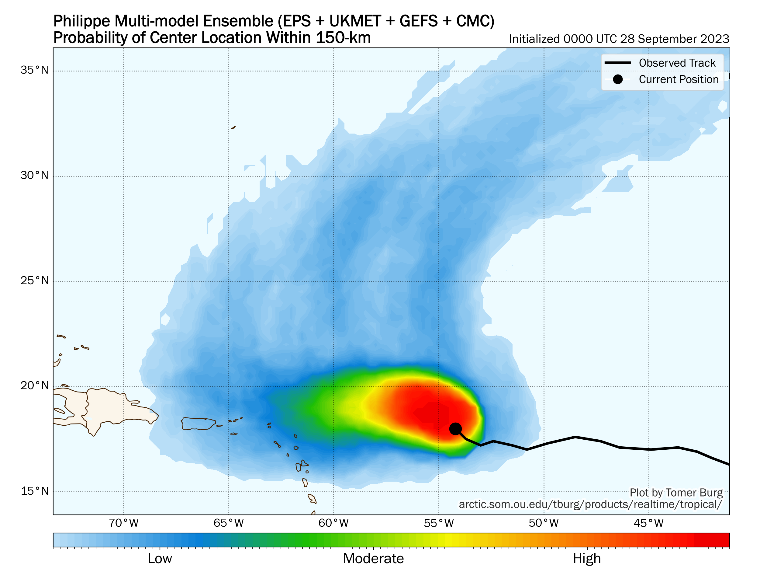
In most possible outcomes, impacts to the islands are not exactly serious, so let’s make that abundantly clear. The arithmetic here is that if 91L (or as the GFS says, Philippe) ever explodes in intensity, it will “feel” upper level steering and turn north out to sea. Is there a chance that the system stays weak, tracks into the islands, and then blows up? I suppose that’s possible, but if it gets to that point, the theory would be that dry air or land interaction limit a lot of upside. So for folks in Puerto Rico or the islands, it would be unlikely that this is a major noisemaker as it comes in. We’ll continue to watch this, but for now the thinking is that it will just be an annoyance out there more than anything. Presumably if one of them does develop into a hurricane and turns out to sea it would happen east of Bermuda. We’ll keep watch and let you know if anything changes.
The medium-range (days 6 to 10): Noise off the East Coast?
We’re starting to get some sort of idea as to what might come next. Models have been consistently showing some sort of upper low or storminess between the southeast Gulf and off the North Carolina coast next week, but they have been wildly different run to run on details. The forecast idea today seems to be honing in on an upper low developing off the Carolina coast before a piece of it drifts southward toward or off the coast of Florida. Another lower-end system could theoretically develop from this, though the odds are fairly low.
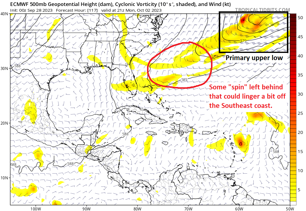
This probably means minimal impacts right now beyond rough surf and rip currents. But this is probably at least worth keeping a side eye on.
Fantasyland (beyond day 10): Still no substance to any threats
We’ve been saying that it may be wise to keep an eye on the northwest Caribbean or eastern Gulf in the late period all week. We continue to be faced with a weather map that does not really show any specific threats; just some noise. So I have no reason to believe that something *will* happen beyond day 10, but I also know that the big picture in the atmosphere doesn’t completely shut the door on that potential. We’ll keep watch.
And we’re about to surpass the normal accumulated cyclone energy and it isn’t even October. With the extremely warm waters this is actually better than what could’ve happened if other conditions were different.
Thank you x100
Much love from Puerto Rico!
Thanks for reading!
“Gulf” appears in the Days 6-10 and the Beyond Day 10 sections. Does this mean anything to Houston?
Not really. The mention is more Eastern Gulf. Anything that forms there is likely to go east or northeast. Cold fronts pushing through Houston in that beyond day 10 timeframe typically sweep storms away this time of year. Space City Weather declared hurricane season over for Houston this week.
Nope. We are good here.