One-sentence summary
An active stretch of weather continues with a major storm developing today and tomorrow, followed by a serious blast of Arctic air across much of the country next week and the potential for an East Coast storm.
The next storm up: More flooding, more Midwest snow, more strong wind
The next storm in our parade is gathering in the Rockies today. This one will track south into the Texas Panhandle and then hook back northeast across the mid-Mississippi Valley into Michigan, Ontario and Quebec into the weekend. At its peak, this storm will likely test some January low pressure records in the Midwest, including in places that just set them earlier this week.
So, yes, it’s active.
There will be some tweaks compared to the storm earlier this week, but in general, the story is similar in some ways. Let’s run through the impacts.
Heavy rain & flooding: The Northeast and parts of the Mid-Atlantic will again be ground zero for flooding risks from this storm. Another inch and change of rain is expected here into portions of Atlantic Canada, on top of saturated ground and ongoing flooding in spots. While these totals are lower than the previous storm this week, the ground is more saturated now than it was then, so less rain can cause issues.

The Weather Prediction Center has the area outlined for the upper end of a slight risk (level 2 of 4) for excessive rainfall, close to a moderate risk.
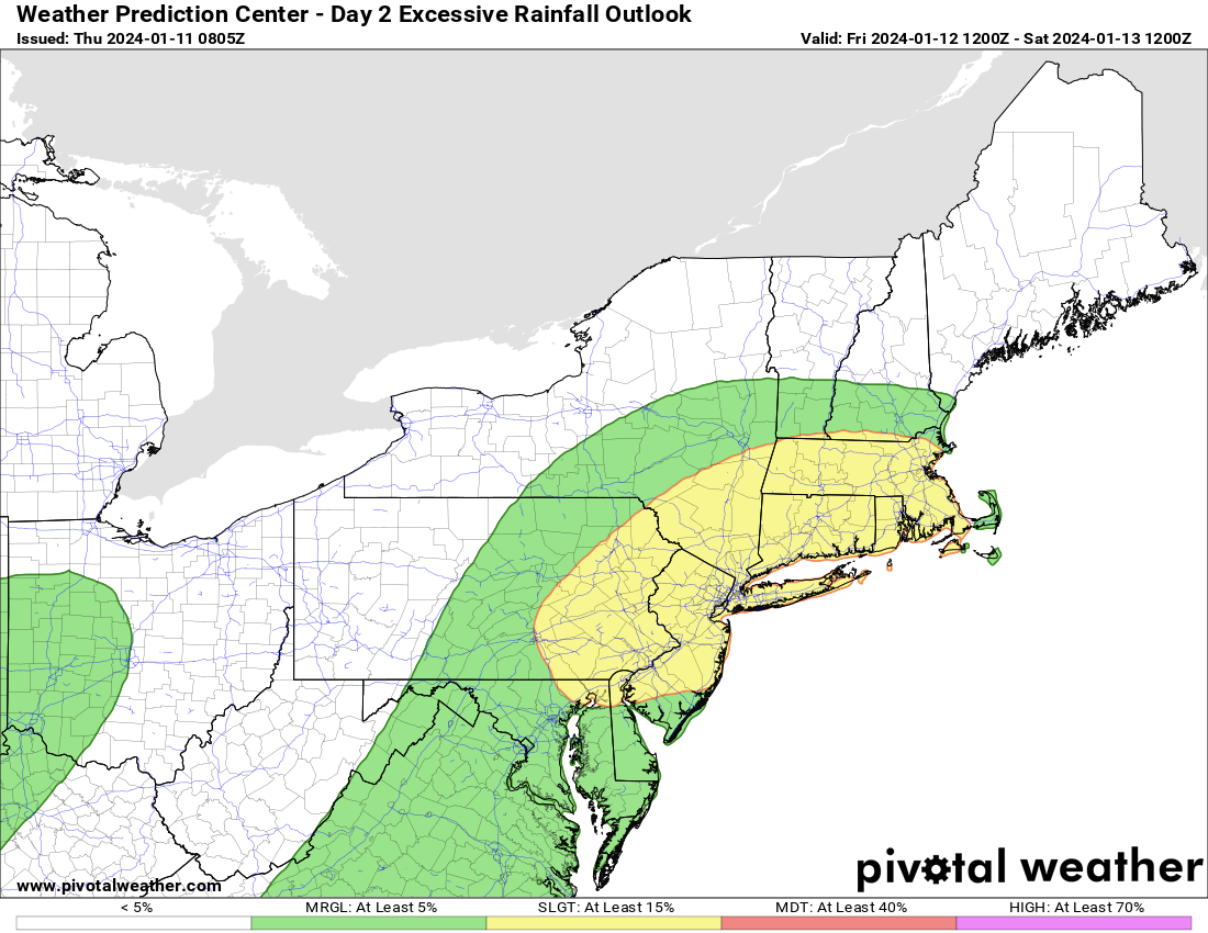
Flood Watches are already posted in parts of southern New England.
Severe weather: Another round of severe storms is likely from northeast Texas into the Lower Mississippi Valley later today, and an enhanced (level 3/5) risk is in place for parts of Arkansas and extreme northeast Texas, and northwest Louisiana.

That will expand into the Southeast on Friday, where another enhanced risk is already established from Alabama through the Carolinas. This map may be updated after publication.
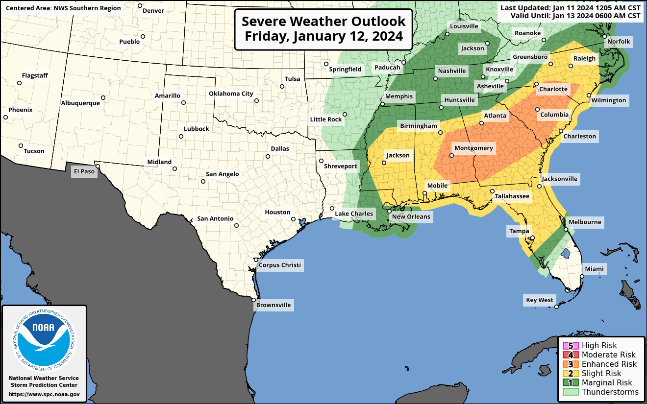
Tornadoes and damaging winds will be a possibility in these areas on Friday.
Heavy snow: The storm earlier this week brought heavy snow in a corridor from Kansas through Nebraska, northern Missouri, Iowa, northwest Illinois and southern Wisconsin into Michigan. Tomorrow’s storm will bring the heaviest snow from Nebraska into Iowa, Wisconsin, northern Illinois (including Chicago), and Michigan into Ontario.

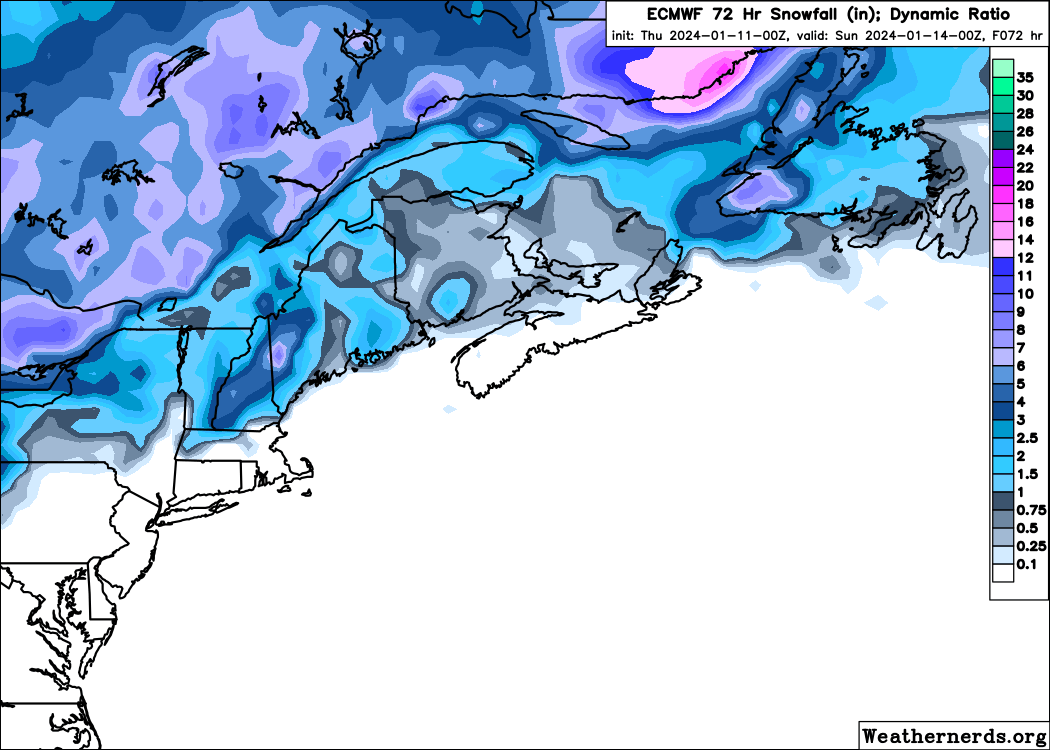
An additional area of heavy snow will be possible in Upstate New York and interior New England, particularly in the mountains. That will extend into Canada with heavy snow across Quebec (outside of Montreal) and in Newfoundland and Labrador.
More travel headaches are expected in those areas.
Meanwhile, as that storm exits east, another storm, the one that will really help drag in the Arctic blast for early next week, will dump snow in the Western U.S.
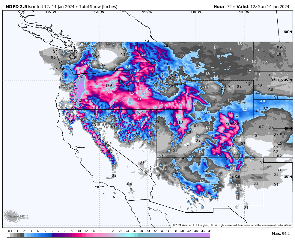
We’ve been in a bit of a snow drought nationally this winter, so this is helping to make up some ground.
Strong winds: In addition to the heavy rain and flooding, heavy snow, and severe weather, widespread strong winds will once again tax trees and power lines across the country. A huge chunk of the nation will see 35 to 50 mph wind gusts in the coming days, with the worst coming in parts of the Rockies, Texas, Appalachia, the Great Lakes, and on the Northeast and Mid-Atlantic coasts into Atlantic Canada.
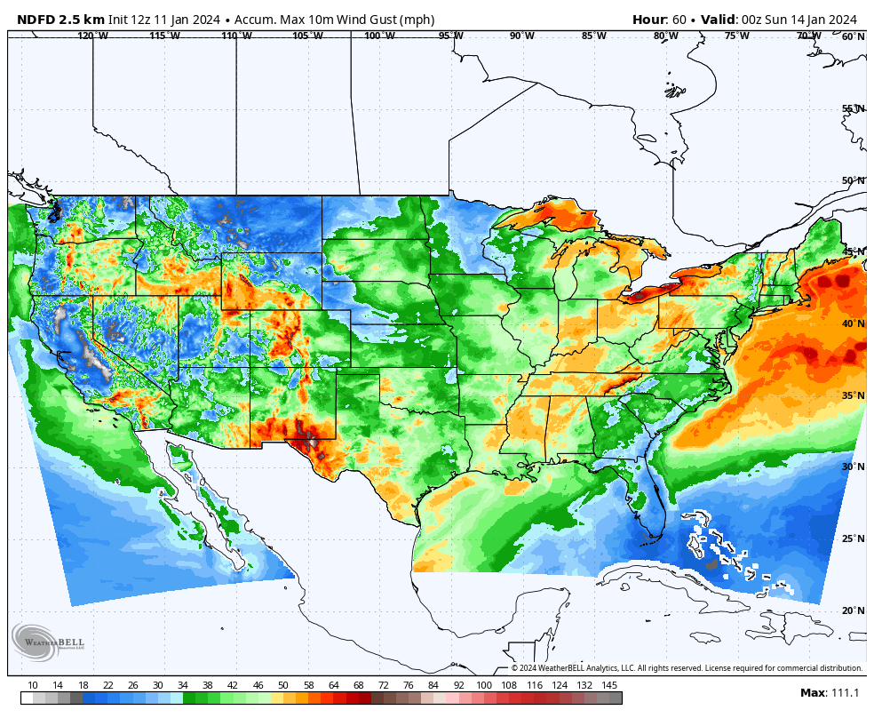
This has been a pretty remarkable week for wind across the Lower 48. I know we have a subset of readership in portions of Atlantic Canada, so I just want to note the wind gusts there as well. They may not be as strong as explicitly shown on the map below (especially east of Nova Scotia), but I just want to highlight that the wind doesn’t magically stop in Maine.

Really an impressive stretch lately.
Arctic blast next week impacts much of the country
As alluded to above, the cold coming next week looks impressive. Nationally, it may be the coldest outbreak since just before Christmas in 2022. Numerous locations are already forecast to reach record lows on Monday and Tuesday next week.

This won’t be as long lasting or potent as what was seen in February 2021 in Texas, but it marks yet another in a series of winters with some sort of cold air shenanigans in that part of the world. The core of the coldest air relative to normal will likely pass over the northern Rockies Sunday and Monday, the central Plains and Mid-Continent Monday and Tuesday, and into the Ohio Valley and Southeast on Tuesday and Wednesday.
For folks in Texas, this will be a prepare for impacts type of cold: Protect plants, pipes, pets, and people. The shorter duration of this event compared to February 2021 should hopefully take some of the more catastrophic problems off the table (like grid failure), but cold of this magnitude in this part of the world can always spring surprises on folks. So please take it seriously and prepare accordingly.
A second push of cold may arrive again next weekend, but that’s TBD at this point.
East Coast storm chances next week?
The rumor mill is cranking on the potential for an East Coast winter storm next week. As the Arctic air slides east, a secondary storm is expected to develop in the Southeast and track off the East Coast. Exactly where it tracks will determine what, if anything is seen in parts of the Southeast, Mid-Atlantic, or Northeast. We’re still a good 5 to 6 days or so away from this, so there’s plenty of uncertainty.
Let’s look quickly at the Euro ensemble “spread” in options for this storm. The IQR values for sea-level pressure shown on the map below from Tomer Burg are high, which tells us that there is considerable spread within model guidance for potential outcomes. The European ensemble runs the European model 51 different times with different tweaks each time. When you see this sort of variability within the ensemble, it lends to lower confidence in the forecast track of the storm. Obviously that will have huge implications on what sort of precip falls and where.
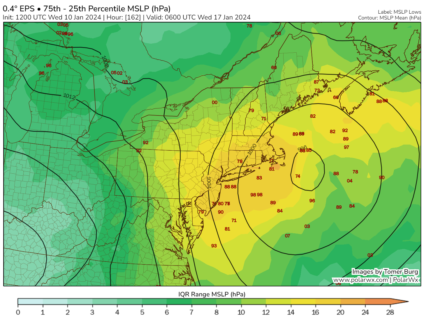
So it’s much too soon to say with any confidence who will see snow and how much next week. Suffice to say, however, there is a storm system likely that will cause impacts on the East Coast, continuing our active weather pattern. Milder weather may be on the horizon for later in January.