One-sentence summary
Today’s post will discuss the return of mild weather, Louisiana crawfish, rain in California, some recent hurricane research, and some too early thoughts on the 2024 hurricane season.
Winter hiatus
After a week where we’ll see heavy rain in the south and wintry precipitation scattered across remnant cold air to the north, the bigger weather story may be what’s coming next week.
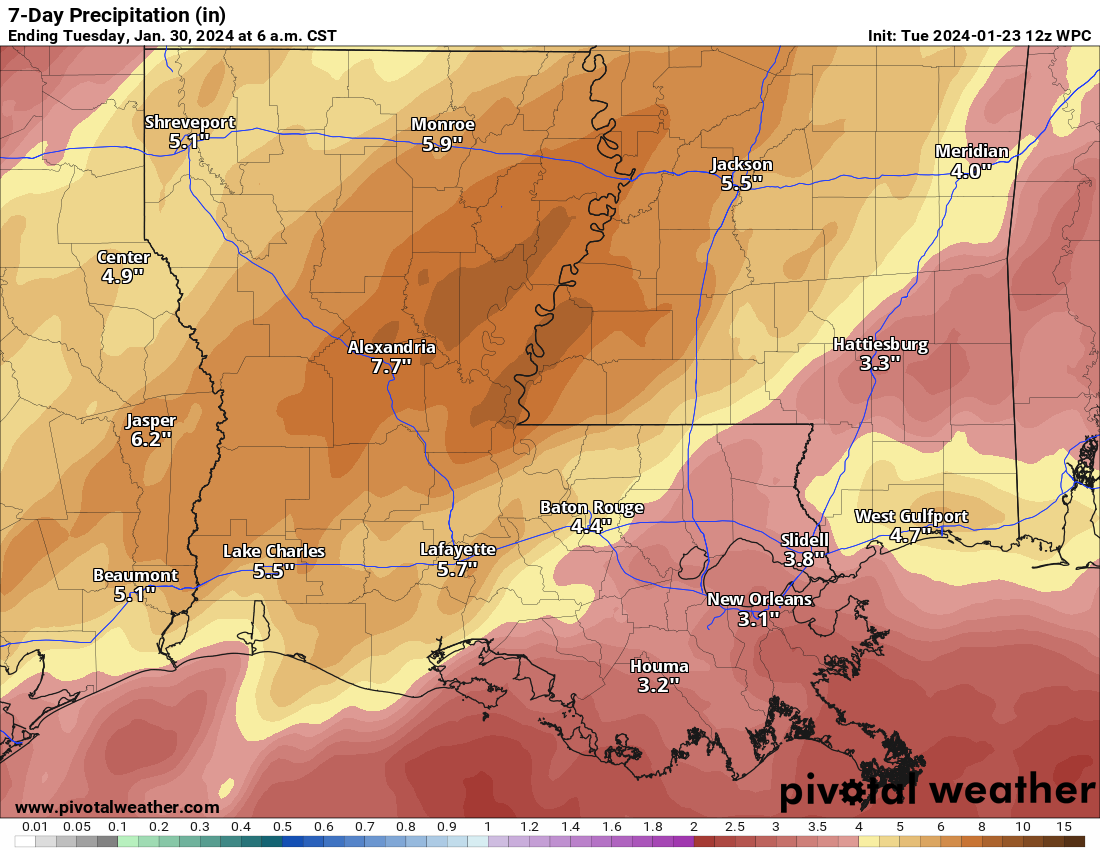
First, we have some flooding concerns in spots in the South to get through, although in some areas, like Texas and Louisiana and Mississippi, this rain is quite welcome. Some of those areas remain in extreme drought. While this is good news in general, it may be too late for crawfish season in Louisiana. Between high costs, the recent cold, and the long-term drought plaguing the region, it’s going to be a tough harvest this year. Mark Shirley of the LSU AgCenter shared thoughts on this season recently, and they were not positive. Not great news for those who bank on this season.
Rains should wind down later this week, setting up a drier week in the South next week. In terms of temperatures, where won’t it be cold for this time of year? Virtually everywhere.
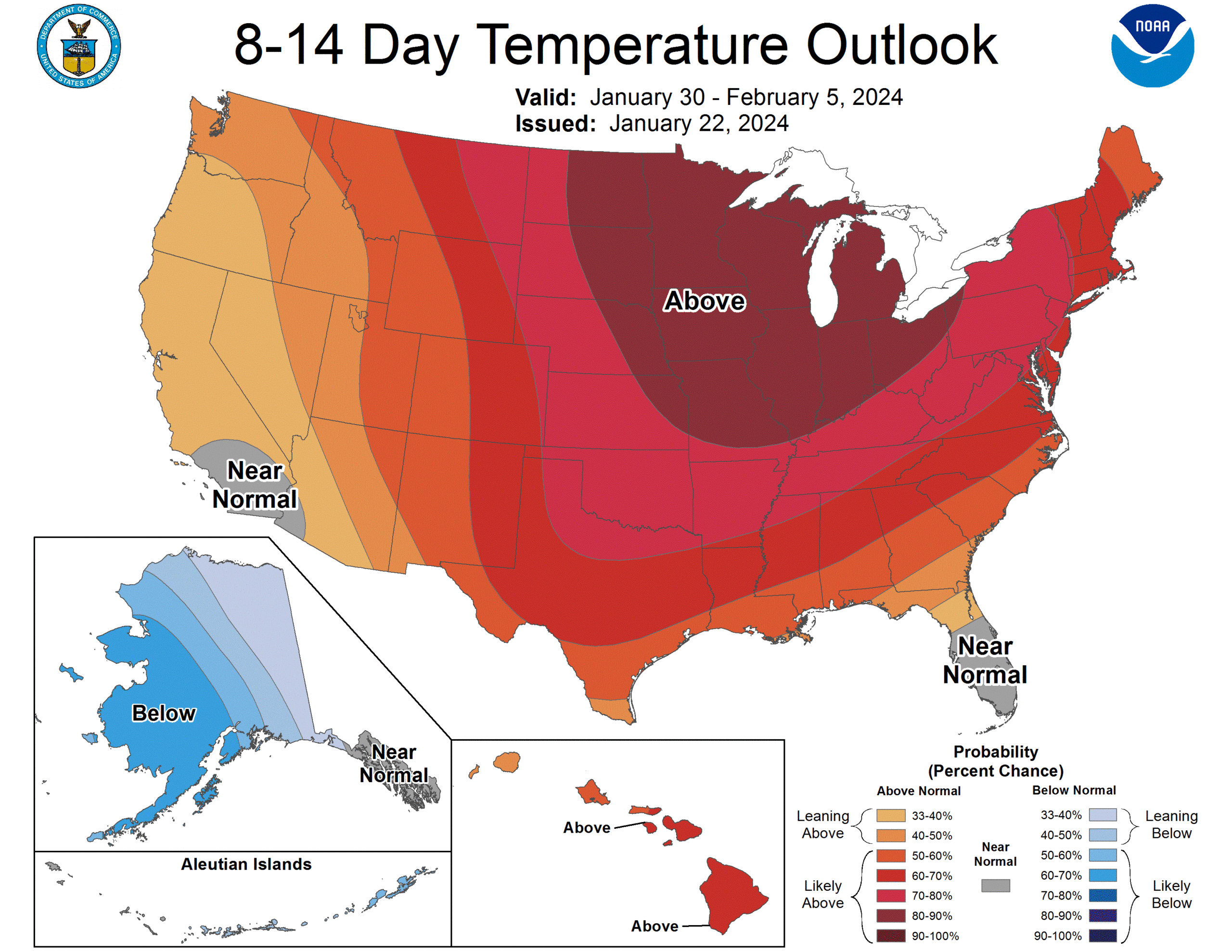
The most recent 8 to 14 day outlook from NOAA’s Climate Prediction Center looks bleak for winter lovers. Weather model data strongly backs this up, and it appears that winter will go on hold for a time as we close January and open February. Though this map stops at the border, it’s expected that warm air is going to flood most of Canada as well, particularly central Canada. The Maritimes and West Coast will be much more moderate than this.
If there is some good news, it comes in California and the West, which is expected to see above average precipitation continuing into next week as well.
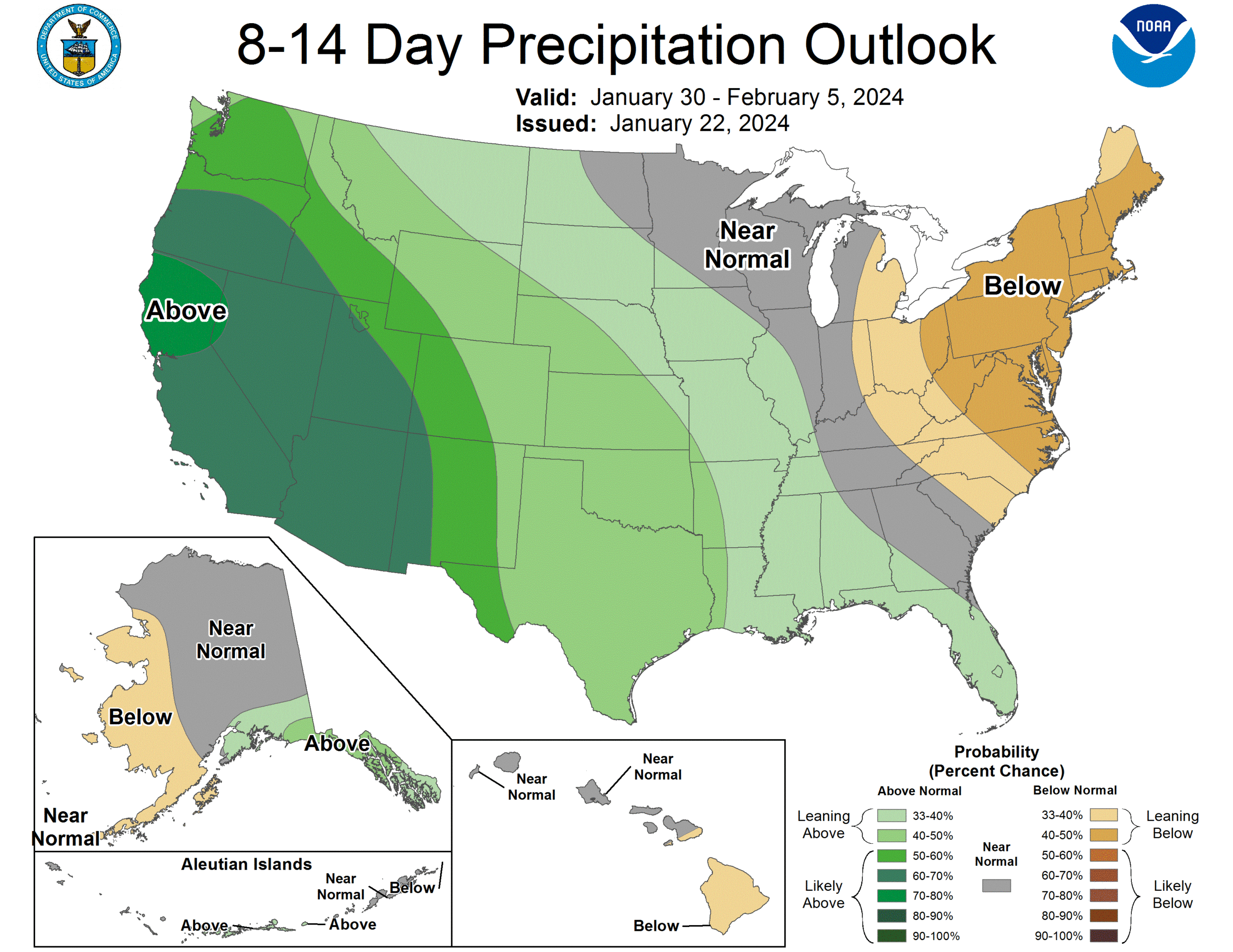
The combination of warm temperatures and wet weather is not always the greatest duo to see out West in winter, but hopefully this can at least continue the snow building process in the higher terrain. Whatever the case, there is high confidence in a fairly wet pattern in that region.
Recent hurricane research: More storms with more rainfall
Shifting gears now, as we advertise ourselves as primarily a hurricane-focused site! I wanted to highlight a couple batches of recent hurricane research that came out in late 2023. Last June, we published an article that summarized a bunch of research on the Gulf of Mexico and rapid intensification. We want to try to continue to keep you informed on general interest research on the tropics, particularly as it relates to the Atlantic Basin and North America.
A preprint being reviewed for publication in Nature Portfolio authored by a group from both the Pacific Northwest National Laboratory and Lawrence Berkeley National Laboratory was posted in early November discussing climate change, flooding, and social inequality from Hurricane Ida back in 2021. The general gist of the paper is like this: We know that climate change will tend to exacerbate social inequality. Disasters tend to hit more vulnerable populations both worse and more often. The paper finds that the climate change impact on flooding is non-linear, which is to say that as the planet warms, flooding should worsen at a faster rate. So as social vulnerability increases, the risk of suffering from deep flooding also increases. “In other words, for deep flood exposure, both past and future warming increase social inequality in the direction that exacerbates relative flood risk for more vulnerable people.”
The study essentially confirms that the flood impacts from Ida’s remnants were worsened by increasing precipitation due to climate change and the most vulnerable segment of the population saw a worse outcome than they otherwise would have because of this. You can see the paper to learn more about their methods and some of the specific numbers they used, which are in line with prior studies done after Hurricane Harvey. While the rainfall element of hurricanes has always been a bad one, we’ve seen several recent examples where it seems as though it’s getting worse, and research in recent years continues to basically confirm that feeling.
Another interesting paper published in November in the European Geophysical Union’s Journal of Atmospheric Chemistry and Physics touches on how aerosols from anthropogenic (human) sources impact the destructiveness of hurricanes. What stood out about this article was their finding that an increasing concentration of aerosols near the immediate coast (say, as storms approach the petrochemical complexes of the Gulf Coast) can lead to a weaker but larger storm with an 11 to 22 percent increase in precipitation within 100km of the center. The study used Hurricane Katrina as a model storm, and they worked to utilize very sophisticated modeling to solve for this.
“For the first time, a 3-D atmosphere–ocean fully coupled regional model (WRF–ROMS) at the cloud-resolving scale was used to simulate Hurricane Katrina in order to investigate the aerosol–TC system with the inclusion of air–sea interaction,” the authors write.
What I think our readers should take away from this research is that it adds to the growing body of evidence that suggests hurricanes are becoming more moisture-laden as they approach land, which is resulting in more rain, more flooding, more damage, and more impacts to more people.
2024 hurricane season early vibes check
There have been some items published in recent weeks about the upcoming hurricane season. I’ve seen everything from people expecting an active season to a very active season to the “hurricane season from hell.” Hyperbole aside, what does the very early data actually show about the hurricane season that begins in just over 4 months?
The first question we’d ask is whether El Niño will continue into this summer. The answer to that question is still an uncertain one. Modeling is aggressively weakening the El Niño event by late spring, as is often typically the case with strong events like this one. The European model below, for example, has us close to “ENSO Neutral,” or “La Nada” by mid-summer, with extrapolation pushing us toward weak La Niña perhaps by the peak of hurricane season.
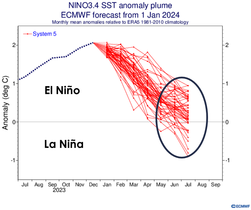
Why does this matter? La Niña events are much more favorable for active hurricane seasons than El Niño events. So if we were to hypothetically tip back into La Niña this summer, it would likely aid an active hurricane season.
Historically, since 1950 in hurricane seasons immediately following a higher-end El Niño, we average 6 hurricanes (with as many as 10 in 1998). A normal hurricane season has about 7 hurricanes, so one could argue that the season proceeding after stronger El Niños may not necessarily skew dramatically higher. From that end, I don’t know that we can currently read too much into El Niño vs. La Niña chances this summer and how they may influence the season.
That being said, one thing we can absolutely read into are sea-surface temperatures (SSTs). The globe’s oceans are undergoing a heat wave of sorts. In fact, water temperatures in the main development region of the Atlantic basin are currently in line with what you would normally expect to see in July. That’s not a typo.
So I do not think it’s a stretch to say that we would expect SSTs to be warmer, if not much warmer than normal again this summer across much of the Atlantic basin. A look at one model in particular, the NMME, which is an ensemble of several different climate models shows an extremely warm look to the Gulf, Caribbean, and Atlantic this summer.
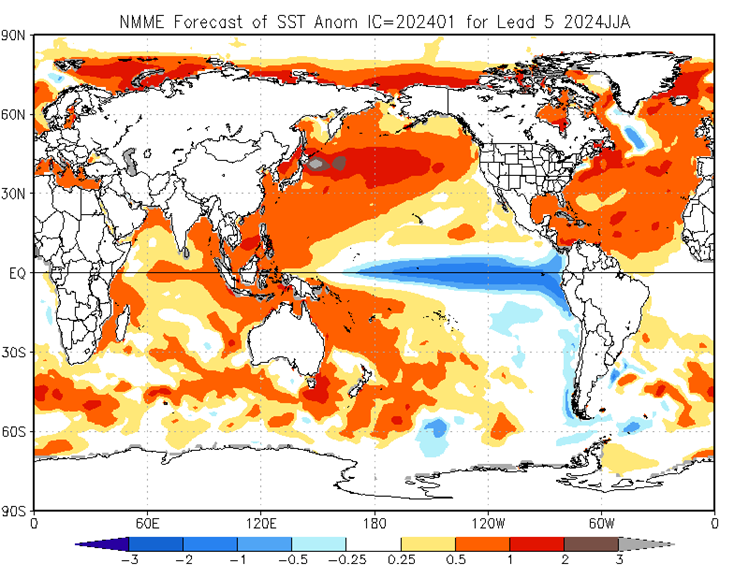
Now, what I might caution about here is that the NMME also has a dramatic La Niña signature in the Pacific that might be a little (or a lot) overdone. Just because these maps are scary looking does not mean that they will verify as shown. But, there’s more than enough evidence right now to suggest that SSTs will skew warm this hurricane season.
So sitting here on January 23rd, I would be willing to say this right now: The combination of warm water and a weakening El Niño probably suggests an active hurricane season ahead in 2024, but there is a very long way to go yet. No reason to worry about the sky falling right now, but I would not be surprised to see some fairly aggressive seasonal forecasts in the months ahead.
Marvelous information, Matt, as always ☺️
I’ve been white-knuckled about the 2024 hurricane this year since I saw the Dec ENSO report. I was kind of expecting us to be in El Niño for at least 2 years. Protection. The heat last summer was extreme, but the dome was a 🛡, at least in my eyes.
I’m shocked by those SSTs. Almost vitrified.
I’m also incredibly grateful for your information and presence. SCW = a Lighthouse. You guys combat fear with logic 💪🏻💕
🌬 ⚘⚘⚘
Thank you so much as always!
Respectfully, please leave the university sociology psychobabble somewhere else. “Social inequity” in the world of weather is a ridiculous concept and insinuates that hurricanes are racist and classist.
That’s what you extrapolated from reading this? But then, I guess you’re going to be okay through all of this, so…
Perhaps read the paper before commenting on it so derisively. This research is important for us to understand targeted messaging and where to increase available forecast resources that may not be as accessible right now.
What a ridiculous comment. Just skip that part if you dont like it. For me that was the most interesting part of the post. And just because you dont want to hear it doesnt make it less true.
People who are just barely getting by usually live in areas where severe flooding is a much higher likelihood. Why? Because that’s the only thing they can afford. The wealthy people either live on property with less risk, or else they have the resources to make their housing much more resilient to the greater flooding and high wind risks present where they chose to live. This is precisely why disasters often tend to exacerbate social inequities. And the very wealthy are also often able to capitalize on disasters by buying up land and housing that have been greatly devalued by a recent disaster, and then waiting for a convenient time to re-sell it to desperate lower income people who have been priced out of anything else. So yeah, social inequity is a real thing. And unfortunately climate change is making it even worse.
Respectfully, please stop expecting everyone to deny reality because you’re opting for ignorance.
Interesting and informative. May even be enough of an eye opener for those of us who typically wait last minute to hurricane prep to put in a bit of effort a bit earlier. Appreciate you guys!
Maybe sometime when you get bored 😁, you might publish a glossary for us who just have to know what the initials mean. MDR, SST, etc. Thanks!
Very interesting academic papers. I’ll re-read the aerosol paper again during a quiet time.
While climate change is a big problem, I feel urban sprawl is the biggest issue for the Houston area. There’s just no where for the water to go. All these cookie cutter subdivisions need to be scaled back and the amount of dirt they are allowed to move, limited. Retention ponds don’t offset the losses of green space and natural drainage.
Correct…in Houston (and elsewhere!) the problem is often framed as just climate change, but it’s extremely multi-faceted. It’s climate, it’s sprawl, it’s urban heat island, it’s land subsidence due to groundwater depletion. All these things are related to humans and worsening similar problems. “Solving” climate change alone won’t solve our vulnerability issues.