Good evening! Welcome again to The Eyewall. We did not expect to be actually covering a storm on day one, but here we are. This is the type of coverage you’ll get with every Atlantic system on this site.
Based on data collected from Air Force Reserve Hurricane Hunter aircraft this afternoon, Invest 91L was classified as Tropical Depression 2 in the eastern Gulf of Mexico.
Wait– Why TD 2? What happened to TD 1?
Back in mid-May, the National Hurricane Center (NHC) determined that a subtropical storm formed off New England back <checks notes> January. Thus, when the 2023 season is in the books, that storm will have the honor of being Storm 1. However, it did not take on the name Arlene since it was classified after the fact. Thus, since this is the second cyclone of the season, it is classified as TD 2. If it becomes a tropical storm, it will be named Arlene. Got it? Good.
Where will TD 2 go?
The official forecast from the NHC looks good. It’s headed south.
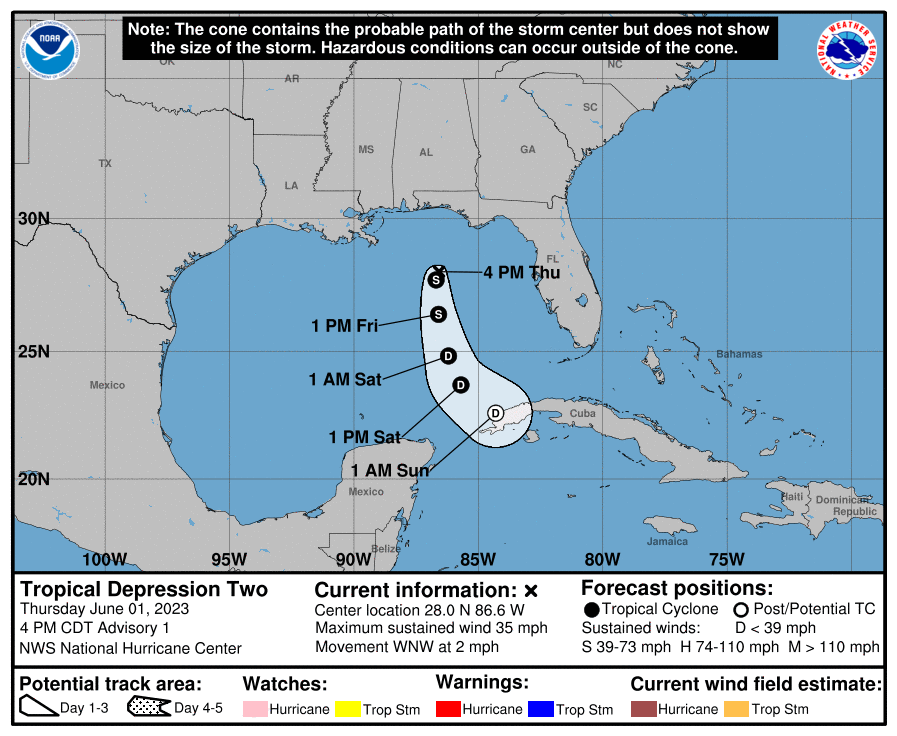
This system is unlikely to maintain status long enough to make landfall anywhere, so there are no watches or warnings posted for any coastlines. TD 2 will drift southward through Saturday before likely dissipating on Sunday (if not sooner) near Cuba.
What impacts should we expect? Florida rain!
As we noted earlier today, the primary thing to watch will be rainfall in the Florida Peninsula. Hardest hit so far today has been central Brevard County in Florida, where radar estimates 3-5″ of rain has fallen. Also, the north side of the Tampa Bay area has seen some heavy rain as well. The map below shows rain totals since about 5 AM today for places that have received over 1.5″ of rainfall.
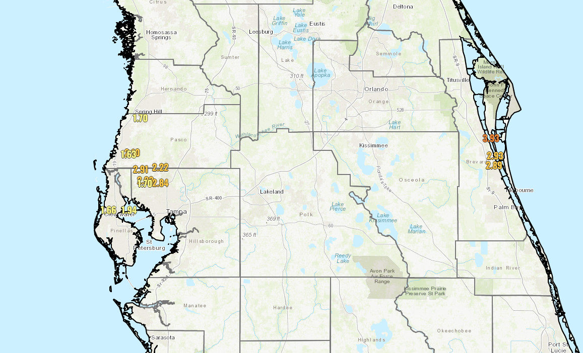
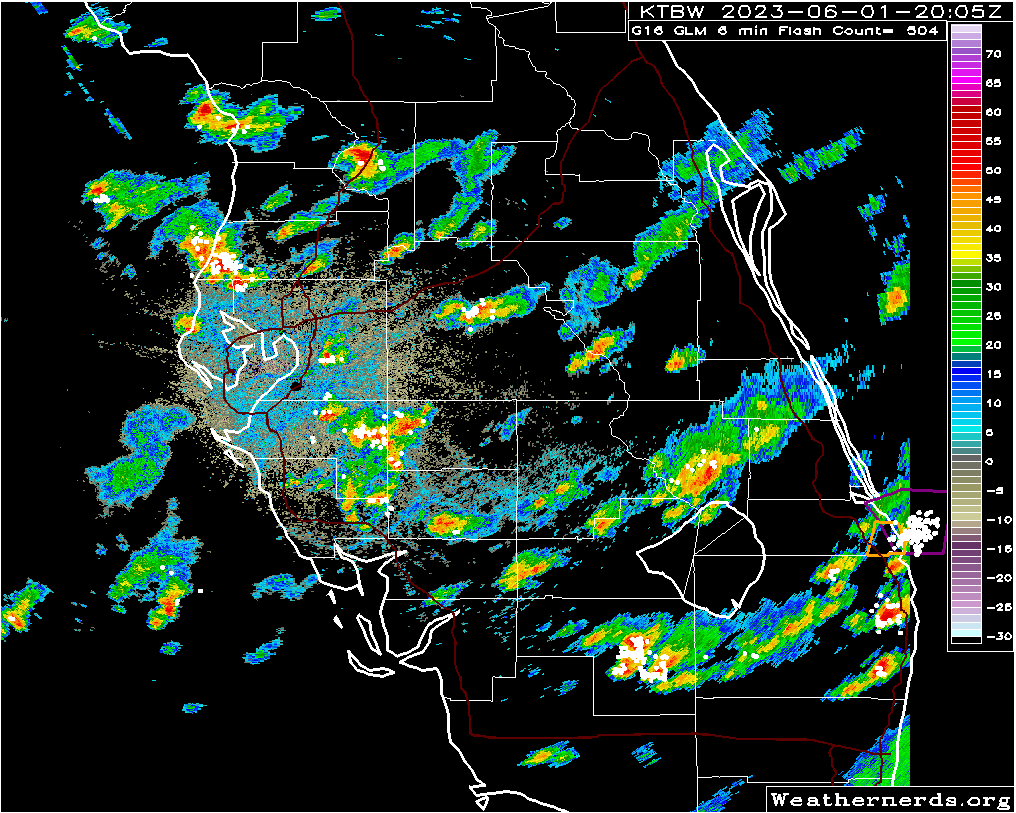
Radar shows pockets of heavy rain extending from the Tampa area south and east across the Peninsula to near Lake Okeechobee before things tail off some. There are also very heavy storms over Delray Beach on the east coast, up through Boynton Beach as well.
The bottom line in all this? Localized flash flooding is possible. You can see from the rain totals that some areas have seen manageable rain so far. Others have seen up near 5″ the last couple days. Those areas will be most sensitive to flooding, and that’s why there’s a flood watch for South Florida. More showers and storms will be likely tomorrow before things settle down a bit.
The final word?
TD 2 may briefly become a tropical storm tonight or tomorrow before it drifts south toward Cuba and dissipates this weekend. The main issue will be heavy rain and localized flash flooding across the Florida Peninsula, as well as perhaps in portions of Cuba (Havana has seen some very heavy rain today). But it’s likely that there will be little trace of TD 2 left by Sunday.
More in the morning!
Love the Eyewall already! So glad y’all are here, keeping us informed!
Great start! Let’s hope that your tracks in 2023 are all like this storm. Somewhere else.
Spot on, as usual!
You guys rock. You are a clinic – in this age of trusting No one – how to be trustworthy- telling us what you know, what you don’t know and caring about who is taking you at your word. Thank you! Keep up the good work!
Just signed up and really liking what you are doing/providing/sharing. The maps, the content, expected rainfall amounts etc. 👍🏼
I thought hurricanes usually go north -ward when they enter the Gulf of Mexico? Right?
Typically, but early and late season stuff can behave…odd. I’ll discuss that more on Friday!
SCW is my local go to, & now I have this on my homescreen. You guys rock!