Good morning, and welcome again to The Eyewall, where we provide hype-free, measured coverage of the Atlantic tropics all season long.
Today, we wake up to Tropical Depression 2 in the Gulf no better organized than it was yesterday evening, and struggling somewhat. TD 2 itself is more of a meteorological curiosity than anything else, although heavy rain continues to be possible in portions of the Florida Peninsula.

One-sentence summary
Tropical Depression 2 is expected to drift south toward Cuba and dissipate this weekend, and although it may still technically attain tropical storm status and will aid in Florida storms, it is not a direct threat to anyone.
All things Tropical Depression 2: Meteorological curiosities and rain in Florida
Again, the system itself is not really an issue for anyone. It’s fairly weak and over open water. From the satellite loop above, you can actually sort of see the center of TD 2, exposed to the south and west of the green-yellow-orange colors, which are thunderstorms south of the Panhandle. That’s an indication of an unhealthy, sheared system. As visible satellite imagery becomes available today, we may see this enter “naked swirl” territory (where the center is completely displaced from any storms). Still, per the National Hurricane Center 4 AM CT discussion, TD 2 may technically be close to being a tropical storm. All you need is an area of 34 knot (39 mph) sustained wind to technically classify it, hence this is mostly a meteorological curiosity at this point.
At a high level, the forecast track for TD2 is mostly unchanged versus yesterday. It drifts south in the Gulf before dissipating near Cuba on Sunday.

Several of you have mentioned, “You know, that’s a bizarre track. Is that normal?” The answer is “No, it’s not technically normal.” It is certainly funky, but often (especially in early season), storms can take these weird tracks. All tropical storm tracks are generally a function of the environment around them. And if we look about 20,000 feet (at what meteorologists call the 500 mb level) over our heads at what’s happening, it becomes fairly clear to see why TD 2 takes this type of track.

The red “L” in the middle of the map, which is a forecast of 500 mb vorticity this afternoon is the approximate location of TD 2. The pattern features strong northerly or northwesterly winds which help to direct the western portion of TD 2’s broader circulation south. Steering currents over Florida and Georgia are fairly weak, so there’s little influence from there, hence all this northerly push pretty much forces TD 2 southward. Winds out of the southwest across Cuba and into the Bahamas help to give it that little eastern turn late, but of course by then, it will have pretty much dissipated.
So, TD 2 is not a direct threat to any land, but the convoluted pattern around the system will help to continue aiding rainfall in parts of Florida today. Flood watches continue for the southeast coast, from Miami-Dade through Palm Beach Counties and around Lake Okeechobee. Over the last three days there have been isolated spots seeing in excess of 3 to 5 inches of rain.
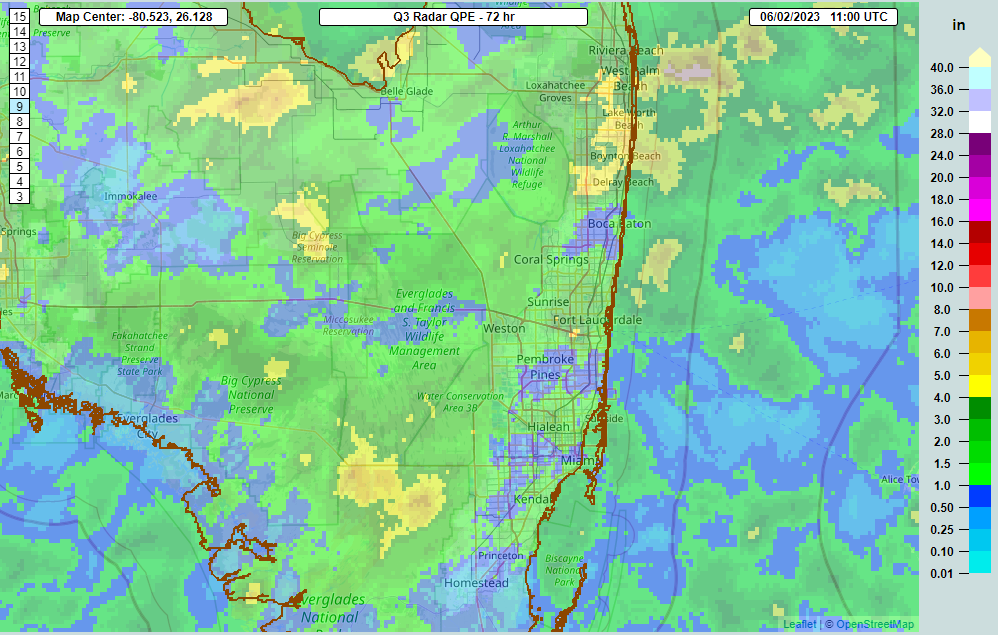
Because of this, and because of the potential that some showers and storms could produce a few more inches of rain and lead to flash flooding, the flood watch continues.
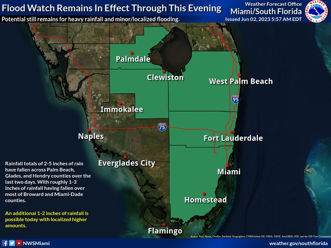
Not all of South Florida will see heavy rain, but some will today and perhaps even Saturday too before things start to return to normal next week and TD 2 experiences its demise.
Medium range (days 6 through 10): Nothing doing
The day 6 through 10 period looks pretty quiet. I would expect the majority of the basin will be covered by decent wind shear, which acts to limit storm development. In addition, it looks like we’re in an unfavorable upper level pattern overall, with more sinking air across the basin as well. It is June, after all, so that shouldn’t come as a surprise.
Fantasyland (beyond day 10): Also quiet
This quiet will probably extend firmly through mid-June and possibly (hopefully?) into late June. Nothing is showing up in the long range that should ruffle any feathers right now.
We’ll be back tomorrow with a quick update on TD 2. Look for our normal daily update on Monday morning, where we’ll tackle what is normal for June as the season begins.
Thanks, guys! As a long time subscriber of Space City Weather here in Houston, was so pleased that you all have undertaken this project to share the hurricane real news with other folks around the country I’ve already forwarded your information to my sister-in-law in Naples, for some no-hype reality that you guys always share.
Keep up the great work it’s much appreciated!!
Having relocated from Houston to Delaware last year, I am delighted to see you’ve expanded coverage to the Atlantic coast. Always feel more informed and safer when you’re around. Keep up the good work.
As a long time follower of SCW I am so happy to read about this new venture. I look forward to more no-hype, straightforward explanations of what’s going on in the local weather world. My husband hasn’t caught on yet, but I notice that more and more he asks “what does SCW say?” I may convert him yet. Continue the great job!
Hello there,
It looks like some of the map (especially the first one) could do with a caption explaining a little bit more the meaning of the colour scale. (Possibly linking to a relavant page when the same type of map is used over an over again).
Oh and by the way, is it imaginable to have occasional comments on what happens over other oceans, when something interesting happens there ? The Atlantic is not the only basin where cyclones sprout !
The post clearly states its a discussion of Atlantic tropics. There are other sites if you want additional info in other parts of world stranger
Thank guys, I love all the details 😀 great job!
🌬🍂💜🌀💜🍂
Thanks for explaining the reasons behind the funky track.
Thank you so much for explaining it so well. It’s great to have a meteorologist take the time with explainations like this.
This is a great explanation. Thank you for The Eyewall!
In my house, I live by what “the guys” are saying. The truth without the hype. Flat out. Thrilled that this will now include hurricane season. Thank you!
Good Afternoon. When did 91L turn into TD2? Was there also a reference yesterday to 91AL?
Hey Scott. So there’s a bunch of stuff there. It was 91L initially. It got upgraded to Tropical Depression 2 yesterday afternoon and subsequently TS Arlene late this morning (after our post). I believe you may be mixing up 91AL with AL02, which is I believe the code that the hurricane center uses for the system in its products. We don’t do things simple in meteorology. 🙂
Great update – thanks y’all! Excited to see this project take off! Will be checking in all season for sure. 🌀 ⛈️
Thank you, Cheryl!