As we’ve done since January, here’s our monthly update on some of the key factors we can look at ahead of hurricane season. We advertise ourselves as being hype-free, and we continue to want to keep folks grounded ahead of this hurricane season. But it’s becoming increasingly difficult to objectively look at things without concluding that the upcoming hurricane season could be a very active one.
Headlines
- El Niño continues to slowly erode away in the Equatorial Pacific.
- La Niña development continues to look plausible, if not likely by August or September, a feather in the cap of an active hurricane season forecast.
- Atlantic Ocean sea-surface temperatures remain excessively warm virtually everywhere that matters.
- We are likely to see some very active hurricane season forecasts get released in the coming weeks.
El Niño’s demise: It continues
Since last month, we’ve seen further declines in the sea-surface temperature (SST) anomalies in the Equatorial Pacific region that defines El Niño and La Niña.
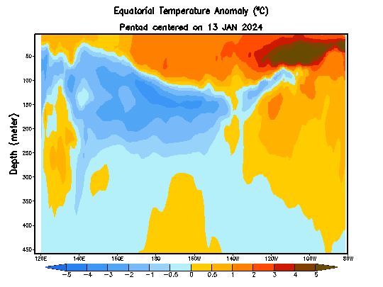
We’re now explicitly colder than normal in the far eastern Pacific, though still warmer than normal across the majority of the basin. So, El Niño is not dead yet, but it’s weakening steadily. This continues to fall in line with predictions that suggest we fall out of El Niño conditions in the key “3.4 region,” which is essentially most of the left half of the image above, by June or so. The chart below is the European Center’s forecast for ENSO 3.4, a proxy for El Niño, and you can see this month that about 85-95 percent of individual ensemble members suggest cooler than average SSTs or straight up La Niña conditions by August.
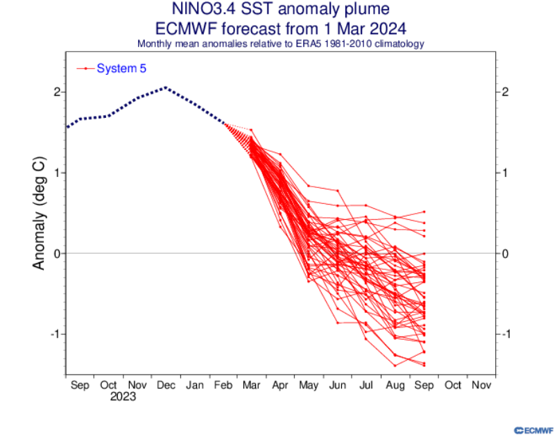
Again, we are in the midst of the “spring predictability barrier” for forecasting El Niño and La Niña, meaning that historically, we’ve struggled to nail the forecast in the springtime. But, given the typical progression of strong El Niño events such as the one that’s fading and the current state of the tropical Pacific, one would assume the odds are stacked in favor of La Niña development by late summer.
This continues to imply that atmospheric conditions in the Atlantic for the peak of hurricane season will likely become increasingly favorable for storm development.
Atlantic Ocean SSTs: Continuing to rage warm
I think we can keep this section pretty brief. It does not take a meteorologist to look at this map of current Atlantic SST anomalies and conclude that the entire main development region (MDR) of the Atlantic, the Caribbean, and Gulf are very warm.
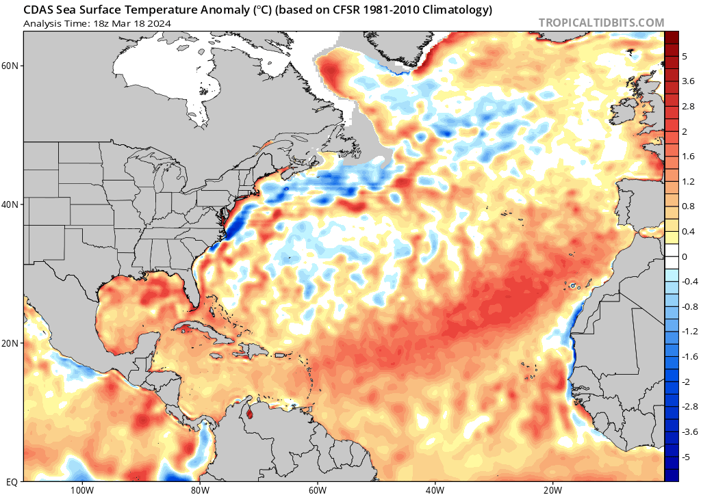
If anything, things look as favorable or more so than they did a month ago. There is plenty of warm water available.
For the Gulf, I tell people not to panic yet because it’s a lot more prone to changes as we get closer to hurricane season. It can swing more based on weather changes as we head toward summer. We’ve seen an alarmingly warm looking Gulf for several consecutive springs now, but it tends to moderate some by summer. I think the Gulf is just warming earlier than normal, so it says less about peak hurricane season than the rest of the Atlantic basin might imply. In other words, because of climate change and other factors you should expect a warmer than normal Gulf in springtime now. The Gulf will probably end up warmer than normal during hurricane season as well, but the hope is that it won’t be quite to the degree above normal it is right now. The rest of the Atlantic? It’s a little absurd for this point, and it does raise concerns if you extrapolate it out into hurricane season.
Putting it all together: A busy season is increasingly likely
It’s still early, very early. But there are clear signals emerging here that strongly favor an active hurricane season. As we get outlooks in the coming weeks, I just want folks to be prepared for the fact that they may end up being forecasts of impressive numbers given these factors. Most forecasts last season predicted an active one in the face of a rapidly developing El Niño. If the SSTs are similar this summer and we transition to a less hostile atmosphere, that virtually guarantees that this season’s forecasts will be big.
One large caveat: This says nothing right now about who might be impacted by storms this season. No one can tell you that with any level of consistency or high confidence right now. If we have 100 storms and they all end up out at sea, it was still a really active season! But few people would have suffered from it. So an active season does not necessarily mean an active season for you. But it does give us some pause and it should encourage you to prepare this year, especially if you’re one who tends to try to ride through the season on hope, luck, or a prayer. I think this is a good opportunity to prepare for a hurricane season just in case. More to come.
I want to say something positive and uplifting here, but we’ve got a potent brew of factors. The physics of this season…
I’ve been trying to make peace w it since I saw the Dec ENSO report, but I can’t settle the extreme unease, esp w the SST anomaly reports coming out so hot w such regularity: it’s become an expectation now.
🎲 🎲
I’m REALLY GRATEFUL for Matt, Eric and the Eyewall, and for everyone else here. Marvelous community. Tysm for being here. 🌬 ⚘⚘⚘
Thank you!