One-sentence summary
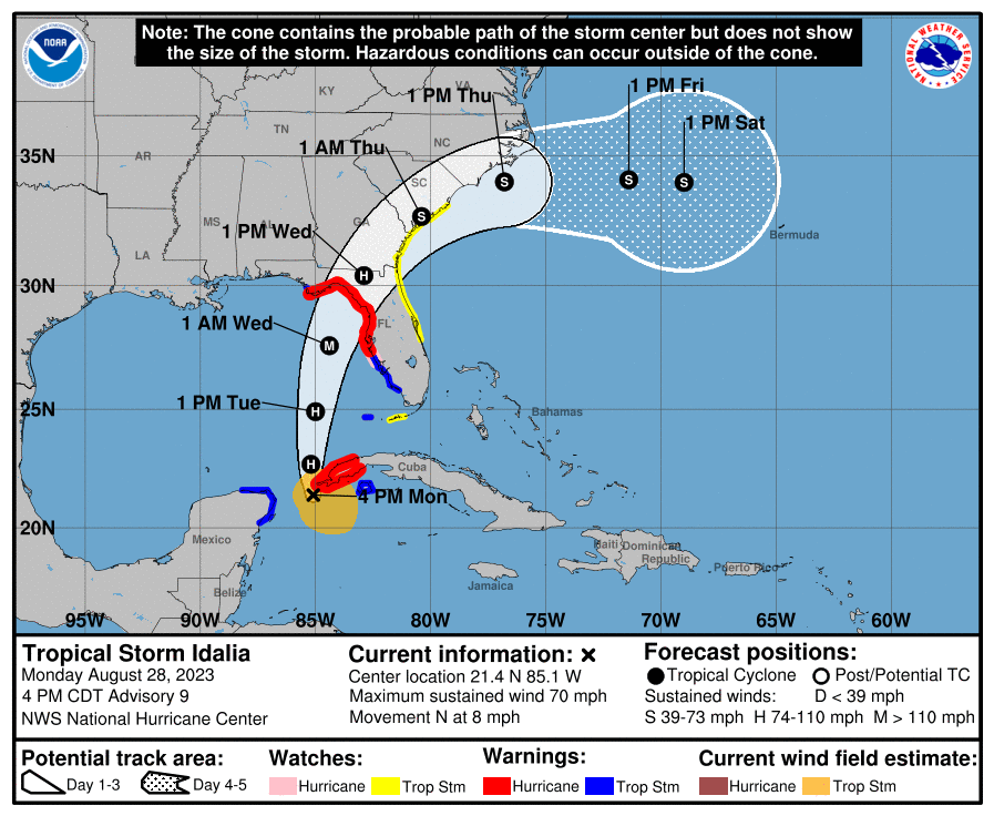
Final preparations in advance of expected major hurricane Idalia should be made by tomorrow morning on the Florida coast, as the storm’s impacts will begin spreading that way by Tuesday afternoon or evening.
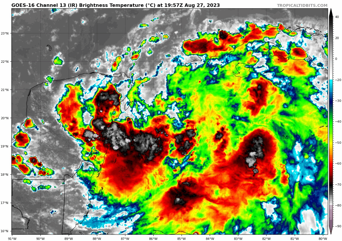
Idalia right now
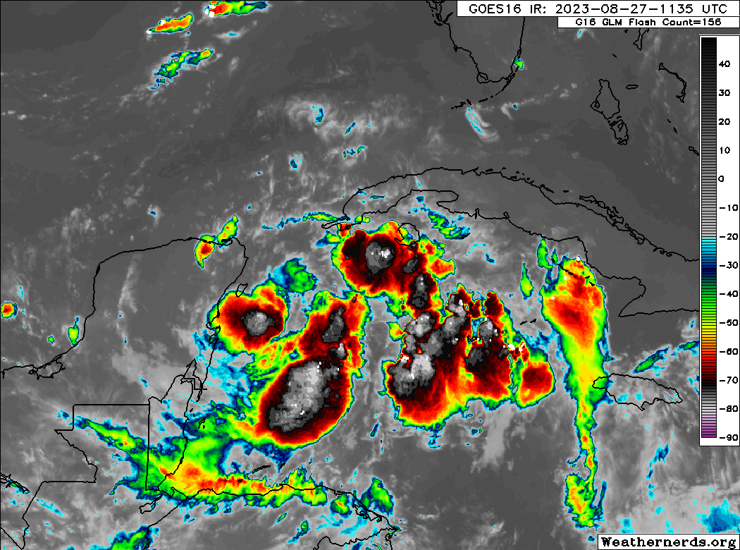
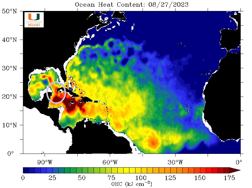
Idalia has been battling some shear today that has held it back a bit in terms of significanr intensification and organization. To be clear, this was expected, and even in the face of this Idalia has held its own and added some lower pressure and stronger wind. As shear moves around a bit tonight and tomorrow and Idalia begins to advance northward, it should begin the process of rapid intensification, just in time for its arrival in Florida. The general rule of thumb in recent years has been that if anything can go wrong in the Gulf of Mexico, it will, and Idalia may add to that list. Let’s focus on impacts today.
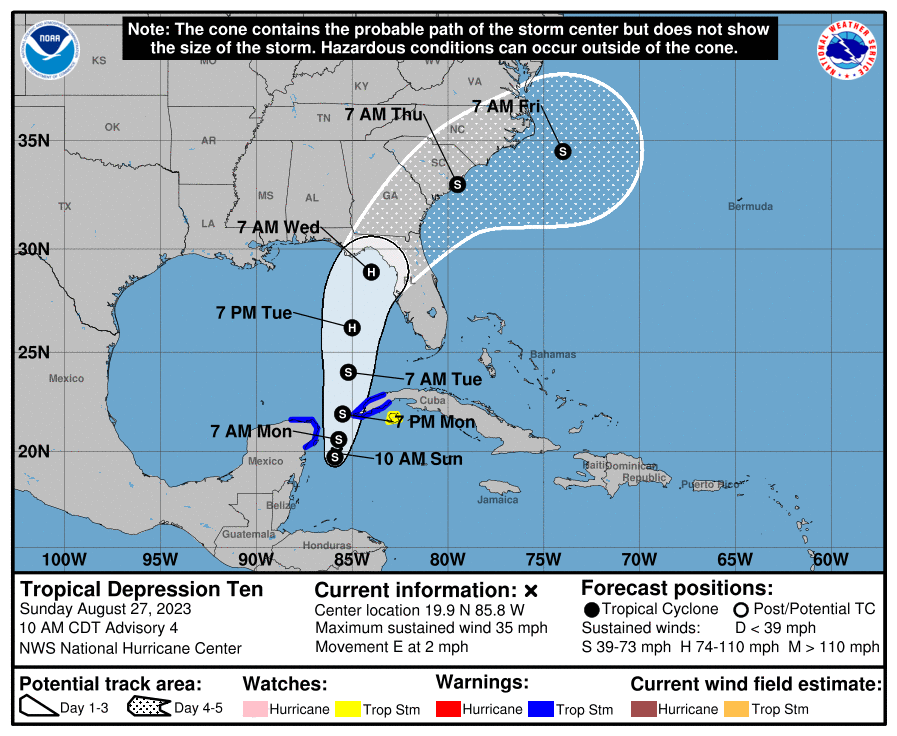
Idalia has not moved a whole heck of a lot today, sitting generally just southwest of the western tip of Cuba.
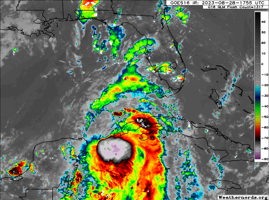
Max winds are currently 70 mph, and Idalia should become a hurricane tonight. Hurricane warnings are in effect for western Cuba. As noted above, wind shear has inhibited Idalia a bit to this point, but we expect that to loosen up some tonight and tomorrow.
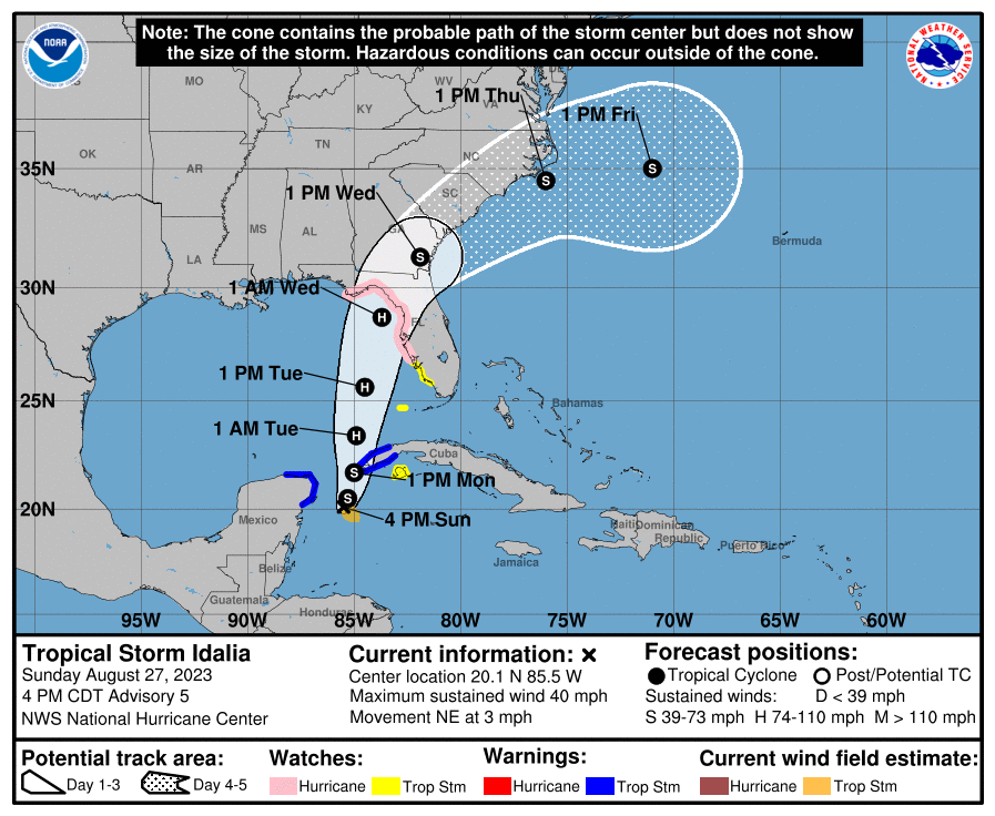
Forecast track & uncertainties
Idalia will broadly come north-northeast toward the Big Bend of Florida. There’s still a good deal of uncertainty on the exact landfall point. Because of the angle of approach from Idalia and the unique geography of Florida, a slight shift in track could yield a decent shift in surge impacts. As we’ll note below, the impacts beyond surge should be relatively baked in now for most spots, with a few exceptions.
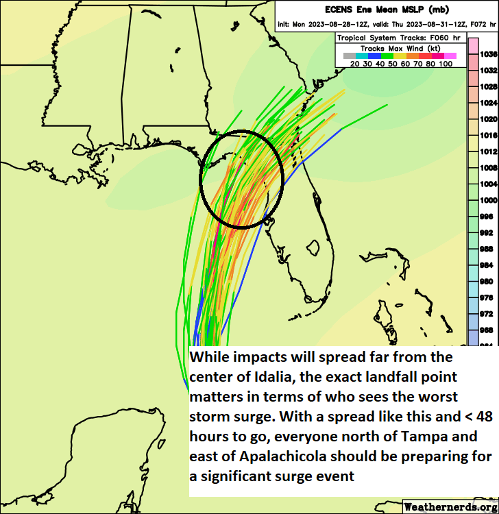
You can see the ensemble spread here from the European model is still considerable, with a handful of ensemble members close to Tampa and many more spread across the Big Bend, as well as a couple as far west as Apalachicola. Recall, the Euro ensemble consists of 51 model runs “tweaked” at initialization slightly to produce some goal posts for outcomes. We need this in tropical situations.
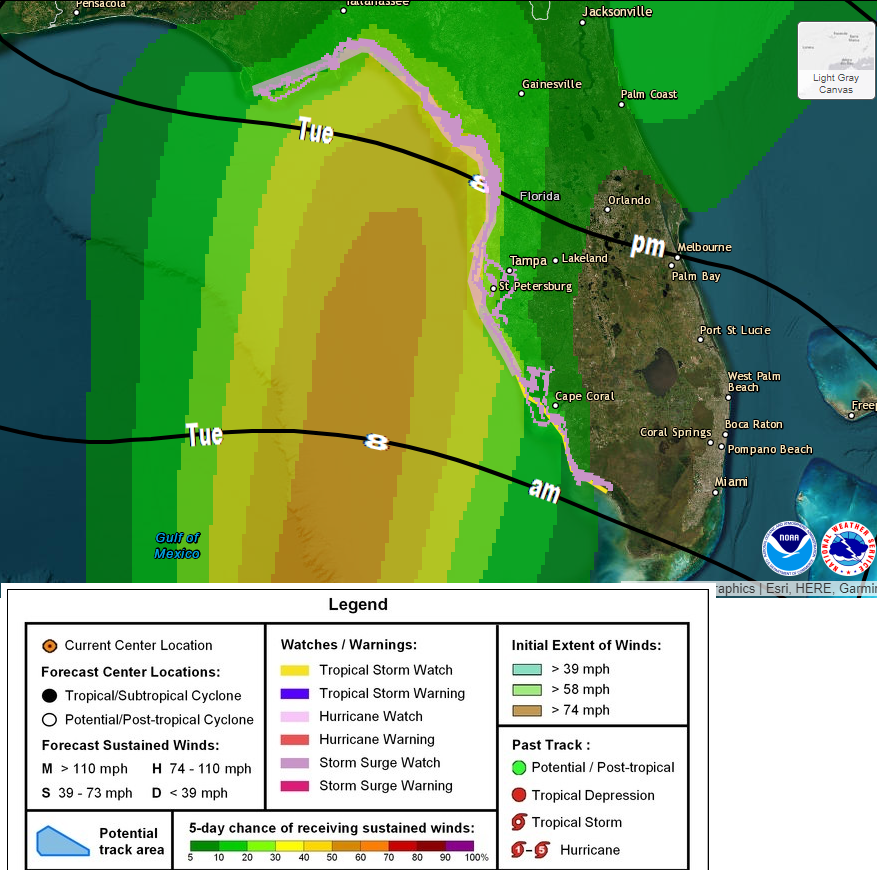
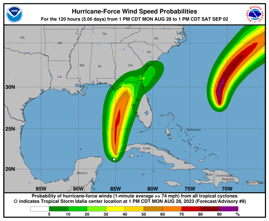
In terms of wind and rain, the forecast will be fairly straightforward regardless of track. The exceptions to this will be the core maximum winds that extend out 10 to 20 miles from the center. We still need to fine tune that. But a broad swath of tropical storm or even hurricane force winds will be possible along much of the west coast of Florida and a bit inland from there.
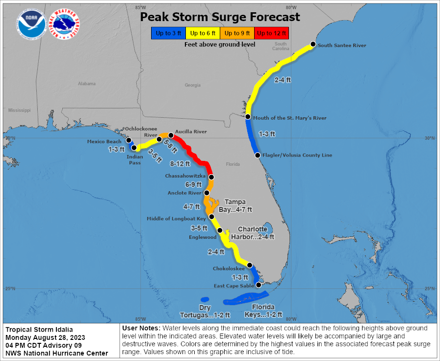
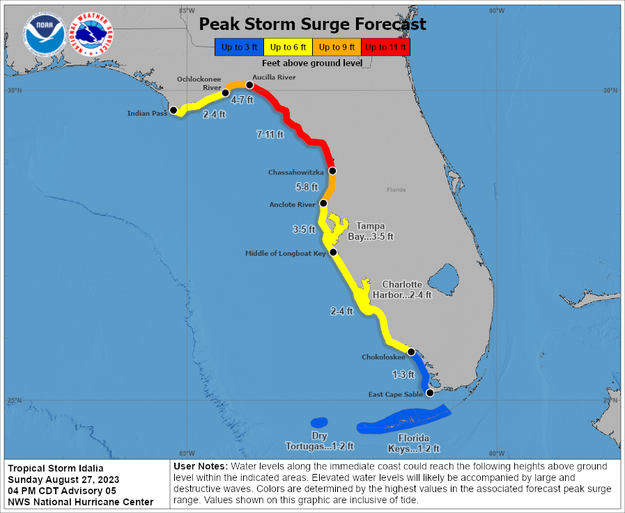
In terms of storm surge, things get a lot trickier. As we saw with Ian last year, the track south of Tampa led to catastrophic surge in Fort Myers and an empty Tampa Bay. Initial forecasts were calling for significant surge flooding in Tampa. We will have to watch the exact track of Idalia closely to determine exactly where the worst surge occurs and where the inflection point between onshore and offshore winds occurs. But in general, significant, damaging, dangerous storm surge is likely in the Big Bend and along the Nature Coast south to near Tampa Bay. Surge impacts in Tampa should be considerable but not quite as serious as farther north. And surge impacts south of Tampa will be modest but notable. Moderate surge is possible on the South Carolina and Georgia coasts as well into Wednesday.
It cannot be overstated that everyone from Apalachee Bay to Sarasota needs to prepare for the reasonable worst case scenario surge, understanding that if the track shifts, conditions could get worse or better depending on that exact track. There will be some element of overpreparation in some communities, which is an outcome you need to accept. Wind is a concern with this storm, rainfall a secondary concern. Surge? The biggest concern I have with this thing. Please take it very, very seriously. There is no modern analog to this storm in the Big Bend, and the surge impacts are likely to be dire.
Intensity
The current National Hurricane Center forecast brings Idalia ashore as a major, category 3 hurricane with maximum winds of 120 mph. We could see a slightly stronger storm (or even a weaker storm!) depending on the track and how efficiently Idalia can undergo its expected rapid intensification.
For folks along the coast from Sarasota north, expect hurricane force gusts possible and sustained tropical storm force winds. Inland, including the west side of Orlando will see tropical storm force wind gusts. The core hurricane conditions will follow near and east of Idalia’s center, likely impacting the Big Bend, Nature Coast counties north of Tampa and perhaps grazing Ocala. Inland hurricane conditions are likely for Gainesville, Lake City, and perhaps the western side of Jacksonville, as well as in extreme southeast Georgia. As long as the storm stays on its current forecast track, Tallahassee should be spared significant impacts.
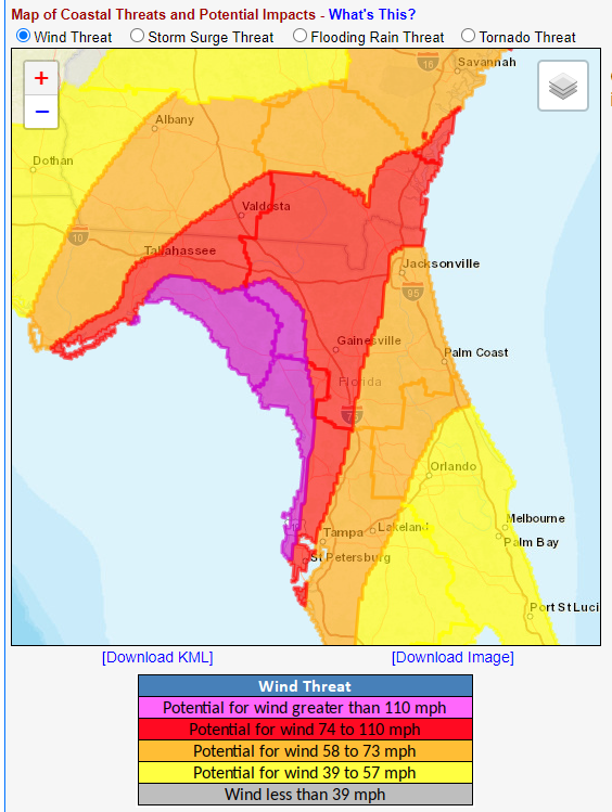
For the east coast, tropical storm watches are in effect from Sebastian Inlet, FL north past Savannah and Charleston to the South Santee River in South Carolina. Storm surge watches cover the area north of the Florida/Georgia line to the South Santee River.
Rainfall
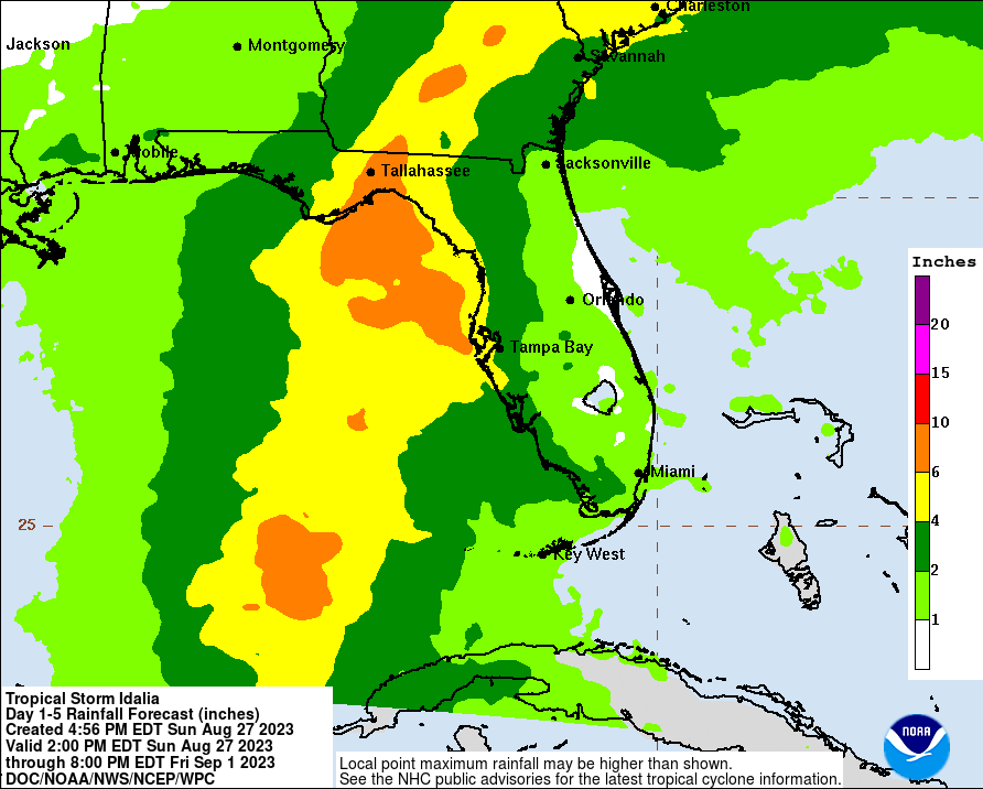
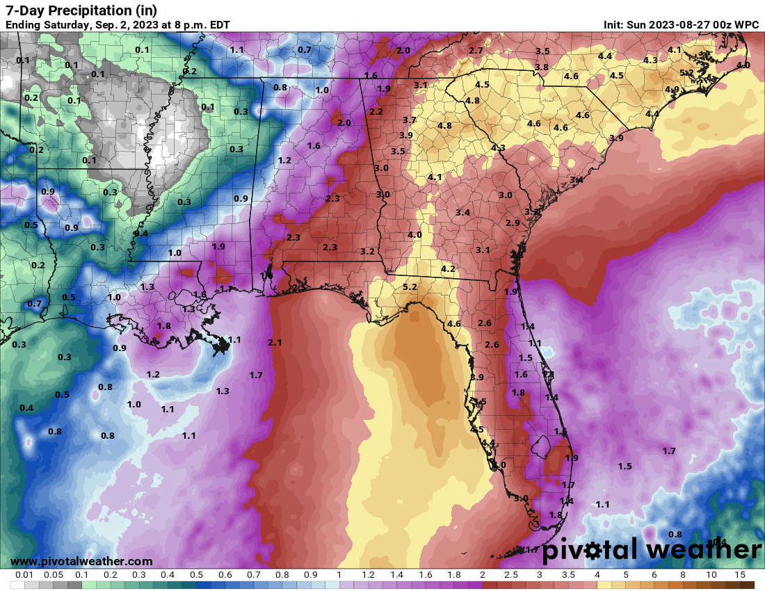
In terms of rain, anywhere from 4 to 8 inches will be possible along the track of Idalia across North Florida, into southeast Georgia and South Carolina as well as southeast North Carolina. Flooding is possible in any of these locations, but the increasing forward speed of Idalia will hopefully help mitigate severe freshwater flooding concerns.
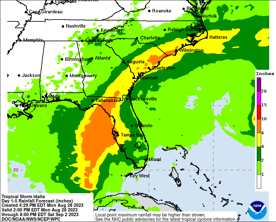
Places like Jacksonville, Savannah, and Charleston will want to prepare for a combination of surge flooding, worsened by rainfall, which will prevent water from draining as quickly as usual. In those areas, flooding could be a little more noteworthy. We’ll touch on that some more tomorrow.
As is always the case with landfalling tropical systems, isolated tornadoes are possible across Florida and into southeast Georgia and the southeast Carolinas.
So, to summarize:
- Idalia is likely to lead to dire storm surge impacts in the Big Bend of Florida with no real good modern analog.
- Surge is highly likely south and east of where Idalia comes ashore, far from the center, but the landfall point matters significantly in determining who sees the worst surge. All of Gulf Coast Florida between Apalachicola and Sarasota should prepare for surge impacts.
- Idalia’s strongest winds will impact the Big Bend and just inland, but gusts to hurricane-force are possible for Tampa and Ocala, and sustained hurricane-force winds may impact Gainesville and the western side of Jacksonville. Idalia’s wind field will extend well east of where it comes ashore.
- Rainfall is a secondary impact in most spots in this particular storm, but still 4 to 8 inches of rainfall could cause flooding in Florida, southeast Georgia, coastal SC and southeast NC.
- Places on the East Coast like Charleston, Savannah, and JAX could be dealing with some moderate surge flooding exacerbated by rainfall that limits drainage.
Our next full update will be on Tuesday morning. Look for a video update this evening on our social channels and follow our Twitter feed and Instagram stories for some other notes this evening.