Invest 94L is in the middle of the central Atlantic, and has about a 50/50 chance to develop as it comes west this week.
Any development would likely be slow to occur and modest impacts to the Caribbean are possible by the weekend.
We anticipate that 94L would fall prey to copious amounts of wind shear in the southwest Atlantic and Gulf before it makes it to the U.S., and it is unlikely to ever be a serious threat to the Southeast.
No other noteworthy developments are expected.
Invest 94L: Worth watching, but not a very serious concern
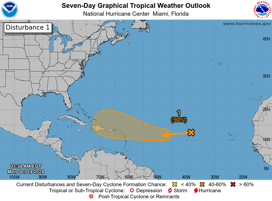
The next disturbance we have our eyes on is Invest 94L, a tropical wave moving through the Atlantic right now. The NHC is giving this about a 50/50 shot at development over the next several days.
A tropical system has about a 50/50 chance to develop in the Atlantic over the next few days. (NOAA NHC)
If you live in Florida, at first glance, your stomach may sink, but in reality it is mid-October, not mid-August. Storms generally do not form here and long track their way to the United States. Also, it’s important to note that the hatched area is not the track of a nascent system but rather the area in which the system may develop. In other words, Invest 94L may develop somewhere in that orange hatched region. If it develops.
So over the next several days, Invest 94L will come westward.
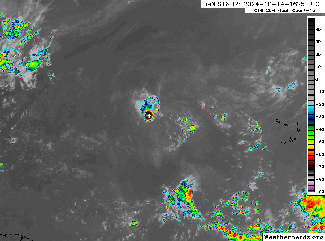
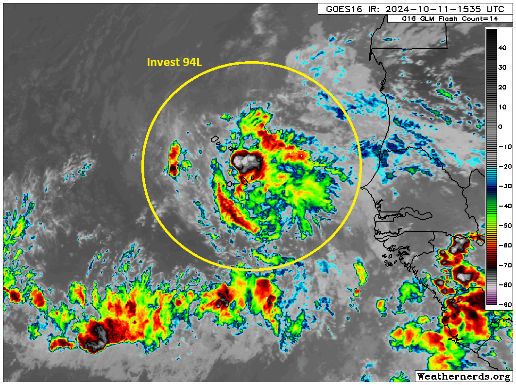
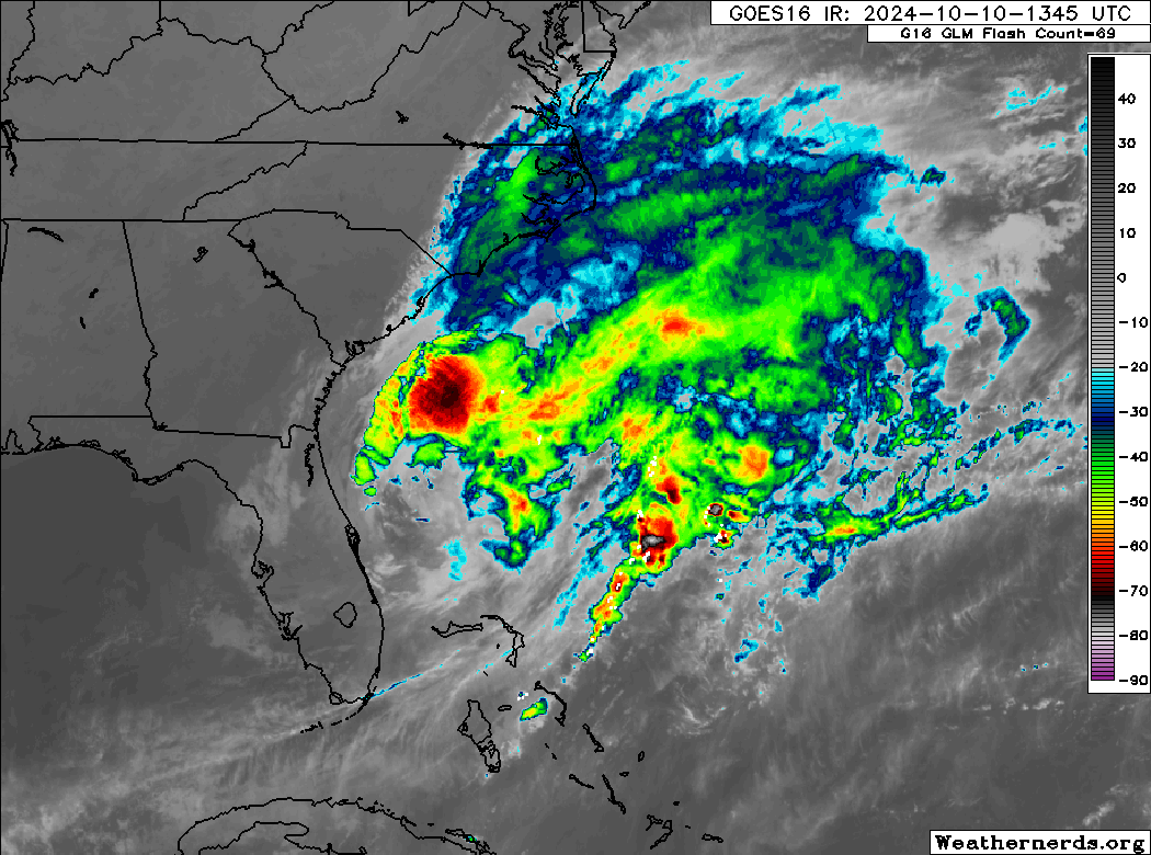
Where is Invest 94L? It’s the little area of thunderstorms in the middle of the image. (Weathernerds.org)
For now at least, 94L is located in a pretty hostile area with lots of dry air surrounding it, and a bit of shear in the vicinity too. Over the next couple days, that may back off some, and that’s when 94L could make an effort to develop slowly. If there is a point where 94L has its best chance of developing, it’s probably in about 3 days as it approaches the northern Leeward Islands and perhaps the Virgin Islands and Puerto Rico. Again, development is probably going to be sluggish here, so we aren’t expecting a Milton or Helene-esque blast of rapid intensification or anything. But if you are in the islands or planning to visit the eastern Caribbean islands this weekend, it’s something you’ll at least want to monitor. Most modeling keeps the ceiling on 94L low as it moves into the islands.
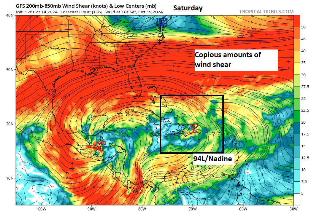
From there, it’s going to be difficult to see Invest 94L making it much farther west while remaining intact. There is a wall of wind shear forecast to be over the Gulf and Southeast this weekend which would almost certainly shred 94L or whatever it is at that point (provided Hispaniola doesn’t get to shred it first). In other words, by the time we get later into the weekend or early next week, it’s difficult to think that this one remains a major concern.
Copious wind shear should do the job on 94L/Nadine eventually. (Tropical Tidbits)
So bottom line on Invest 94L: Watch it in the Caribbean. Keep tabs on it to the west. But in general, we do not believe this one will be a major issue at this time.
Elsewhere
There’s nothing else we really have our eyes on. We are seeing some periodic signs of Caribbean development from the GFS model in particular. That seems to have very limited ensemble support or support from other models that have performed well this tropical season. At this point, the only organized system they seem to be picking up over the next 7 to 10 days is Invest 94L. So we anticipate that’ll be the only real game in town for a bit.
Leslie heading out to sea while Invest 94L may develop just west of the Cabo Verde Islands.
We are monitoring the western Caribbean next weekend, but there is still nothing of specific significance that we can state about the potential of development, and we urge you to not fall prey to one-off model runs that show scary outcomes.
The close of our post talks a bit about or mission and goal for this site, as well as what we don’t want to be!
Leslie and 94L way out in the Atlantic
We’re beginning a period of calmer conditions in the tropics. At least as it relates to land-impacts from tropical systems. Milton is now history. Leslie is still churning away in the open Atlantic but it too will soon be history.
Tropical Storm Leslie may brush the Azores as a non-tropical storm on the way out to sea. (NOAA NHC)
Off the coast of Africa, we currently have Invest 94L. This looks ready to pop in the next few days. Model guidance agrees on this, and the overall environment looks decent. Steering winds should bring it west across the Atlantic.
Invest 94L looks fairly healthy over the Cabo Verde Islands and could develop in the next few days as it migrates westward. (Weathernerds.org)
While this is unlikely to threaten the U.S. at any point, this is at least something to monitor if you live in the Caribbean. It’s still a solid week away, but with water temperatures still sitting near all-time records in the Main Development Region (MDR) of the Atlantic, the right environment could easily incubate a strengthening storm.
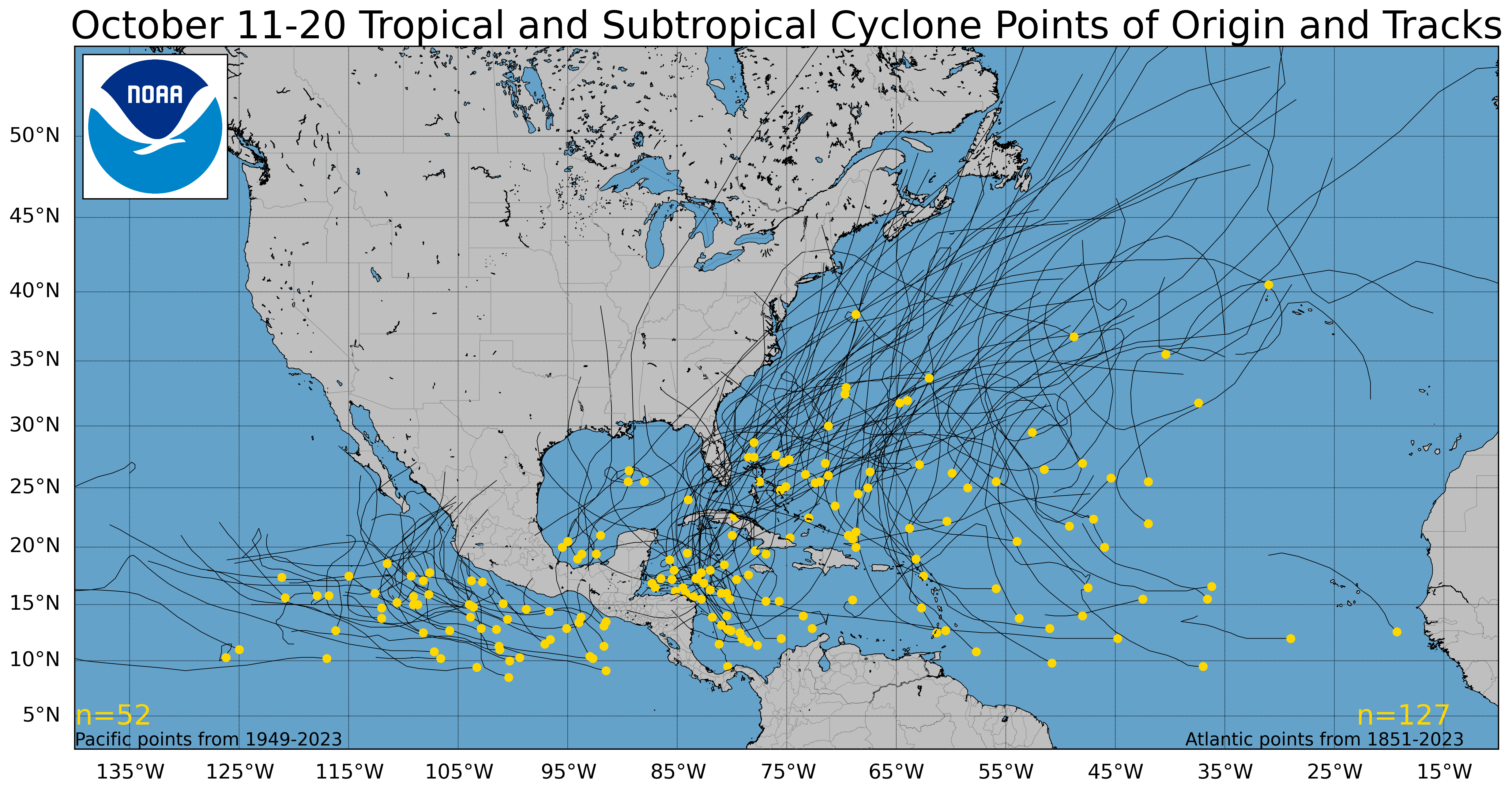
Tropical cyclone origins and tracks since 1851 from October 11th through the 20th. (NOAA NHC)
That said, this would be unusually far east for a storm to develop this late in the season. Only one system has formed east of the Cabo Verde Islands since 1851 in mid-October, and only a couple others within 10 degrees of longitude west of there. If 94L forms soon, it would be an oddity. Most storms that form in the central or eastern Atlantic this late in the season tend to curve out to sea before getting to the islands, but obviously some have come close.
We’ll keep an eye on 94L and have more for you Monday.
Eyes on the Caribbean?
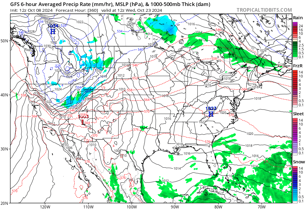
There was one particular GFS operational model run yesterday that sent some folks into a tizzy over the potential for a big hurricane in the Gulf in about 10 to 12 days. I want to remind you all that operational model runs like that specific GFS run are not suited to trust more than 5 to 7 days out. Even within 5 to 7 days there are often issues and miscalculations with the model. So don’t panic when you see that.
Zero consistency between runs on the GFS operational model and little to no additional model support for a storm in the western Gulf. (Tropical Tidbits)
No consistency, no trustworthiness.
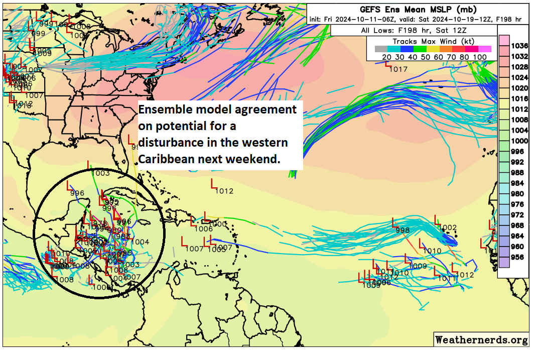
Most models agree in a tropical disturbance trying to form in the western Caribbean sometime later next week.
There is decent agreement on the potential for a tropical disturbance in the western Caribbean next weekend. (Weathernerds.org)
This is a century away in model terms, and there is very little agreement on where things go from here, if anywhere at all. We have a very long time to watch this area, but I would encourage you not to stress over things. A lot of moving parts will impact whether or not this develops, including cold fronts, locations of specific features, etc. Right now, we simply have nothing intelligible to really say about this other than a disturbance is possible there in a week’s time. Anyone selling anything specific at this point should be added to your “do not trust” list immediately. More on this Monday.
Friday featured sponsor: Senior Health Services
Thank you to Senior Health Services and all our sponsors for their support of The Eyewall this season!
Need help with Medicare? Is your plan changing? Senior Health Services is a full service Medicare brokerage providing free Medicare help. Millions of Americans on Medicare are seeing changes to their plans due to the Inflation Reduction Act. If your plan benefits are changing, benefits being cut, costs going higher, or even terminated altogether, we stand ready to assist. We work with Medicare Supplements, Medicare Advantage, Part D plans, and more. If you need help, it’s free! All you have to do is visit us at seniorhealthservices.com or call us at 281-894-7540. We serve most states. Did we mention it’s free? Don’t do it alone. Call us if you need help.
A final word
We have had some very spirited comments in recent posts, which have been useful and interesting conversationally! We encourage that. We just ask to keep it respectful. I don’t want to have to moderate or shut things down at any point. We trust y’all to treat each other with courtesy.
Secondly, I just want to clarify a couple misconceptions I read. We did not build this site for Houston. While we hope Houstonians will use it as a companion to the robust information we offer at Space City Weather, we built this site for everyone else, truthfully. There are a handful of good blogs out there talking about the weather, and we want to join them. I hope any of you in Florida, Georgia, Louisiana, or the Carolinas will share this site with your friends and family. We try not to advertise and prefer our growth to be by word of mouth in most cases. Let our work speak for itself.
There are two primary reasons we don’t post 5 or 6 updates a day when a storm threatens someone. First, honestly, not a whole lot changes from morning to evening. Yes, a storm can rapidly intensify or change intensity but in general, that doesn’t have a massive impact on the forecast, and if it does, in most cases a second post later in the day will cover it. We live in a world with frequent, *URGENT* push alerts. We aren’t that. We don’t want to oversaturate you with repetitive stuff just so we can show we’re still on top of things and generate traffic for the sake of traffic. We want our posts to carry value and information, not regurgitation. Second, we are not local experts on Tampa or Jacksonville or Cape Hatteras or Charleston. We could never be. We know a bit, in some cases a lot about geography. But the local nuance can only be covered by local experts. That’s why at a point, we want you to find trusted local sources of information to turn to, such as your local NWS office or a particular broadcaster or online source in your region. Simply, we cannot do at scale what they do for you locally. So yes, please use us! But make sure you’ve got someone not from Houston that you’re following to give you that local insight or nuance that you need.
As always, thanks for your support, follow us on social media, and share us with your friends and family!
Hurricane Milton is now a non-tropical storm as it moves out to sea.
A very historic tornado outbreak, flash flooding, and storm surge were all elements of Milton that were notable in Florida.
In the deep Atlantic, Hurricane Leslie is headed out to sea.
There are hints of additional development chances late next week in the western Caribbean, but it is way, way too soon to speculate on whether that happens for real or where it would go if it did.
Milton’s mess
Hurricane Milton is moving farther away from Florida this afternoon. We say good riddance. There will be a number of things to discuss in the wake of Milton, from its incredible intensity ramp up to its precipitous weakening and how that may have played a role in surge, track, winds, flooding, and the daytime tornado outbreak in eastern Florida. We’ll place a bookmark here and come back to it at some point in the offseason I think.
Milton is now transitioning from a tropical system to a non-tropical system as it moves out to sea. (Weathernerds.org)
The elements of Milton that were most noteworthy in my opinion:
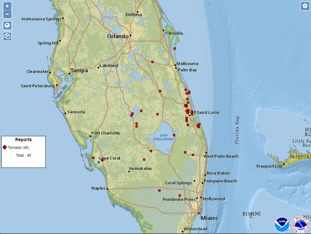
The tornado outbreak in eastern Florida. Over 120 tornado warnings were issued in Florida yesterday. You can read about historic Florida Peninsula outbreaks here through 1993. There was another major tornado outbreak in Florida in February 1998. Tornadoes are not uncommon in Florida, but outbreaks of this magnitude are. So far there have been 45 tornado reports in Florida from yesterday. Ultimately, this will be under that value in terms of number of tornadoes probably. But no doubt Milton produced a truly historic tornado outbreak.
Each red dot signifies a tornado report from yesterday. The hardest hit area was from Palm City through Fort Pierce into Vero Beach. (NOAA SPC)
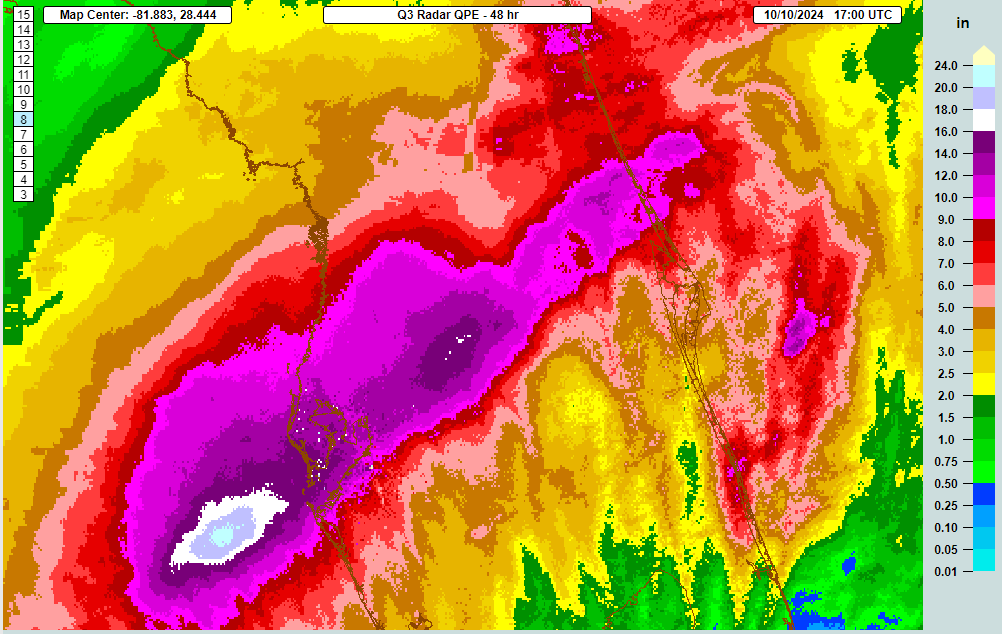
The huge footprint of heavy, flooding rainfall. We had a wide area of rain totals that exceeded 10 inches with a 100 to 500 year return period between Tampa and Daytona Beach. The flash flooding is likely to have caused significant damage across the region.
Total rainfall in excess of a foot (dark purple) covered a wide area of the I-4 corridor. Heavy rain also occurred to the north into Jacksonville. (NOAA NSSL MRMS)
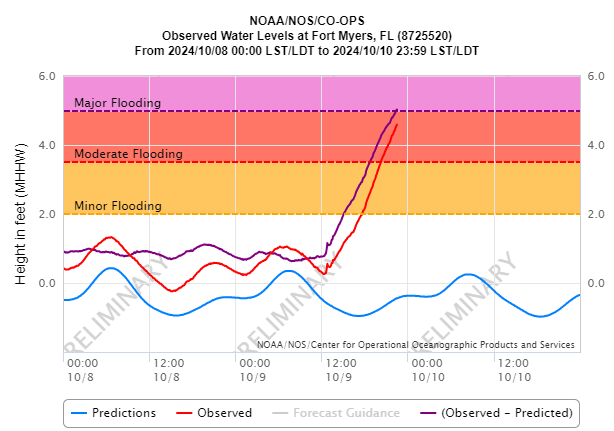
Then, obviously, the storm surge. How bad was it between Longboat Key, Sarasota, Siesta Key, and Venice? That’s only just now becoming clearer. It’s been tough to find hard station data but I have seen a report of 7 foot water levels near Venice, which would equate to at least 6 to 7 feet of surge. One would assume that water levels were somewhat higher to the north of there near Siesta Key and Sarasota, possibly up to 10 feet or so.
Between Milton and Helene, we’ve had a rough few weeks in the Southeast. We hope for the best for those impacted and for the recovery process to be as painless as possible.
What’s next?
In the deep Atlantic we have Hurricane Leslie that is on its last legs as it motors out to sea.
But there are hints on the models at least of a new potential disturbance in the Caribbean. This is still about a week or more out. But it seems that if something were to develop in the next 2 weeks, this is where it would happen.
The potential for new development in the western Caribbean is not zero late next week. But it’s too soon to speculate on what that looks like or where it goes. (Weathernerds.org)
While this will certainly get a lot of folks riled up, it’s important to note that with this being a week or more out, there is no guarantee anything will develop, nor is there any knowledge of where anything will go if it does develop at this point. All we can do right now is speculate that something could possibly develop in the western Caribbean in a week to 10 days. That’s a long time out, so don’t start stressing right now.
Milton made landfall near Siesta Key earlier this evening.
Storm surge of 8 to 10 feet is likely to have occurred near Sarasota through Venice.
Surge of 5 to 6 feet is causing major flooding in Fort Myers, Naples, Punta Gorda, and elsewhere down the coast.
Tampa Bay was spared the worst case scenario surge.
But major to catastrophic flash flooding is now ongoing in the Tampa metro area, with torrential rain expanding north and east up I-4 toward Orlando.
Over 1.5 million customers experiencing power outages now in Florida.
Hurricane Milton made landfall near Siesta Key this evening as a category 3 hurricane. An approximately 10 foot storm surge came ashore in Sarasota, while Tampa Bay ranged from negative surge (water being flushed out of the bay) in the upper part of the bay to about 2 feet in the lower part. Had Milton made landfall even 15 to 20 miles farther north, we’re talking about a 10 to 12 foot surge into Tampa Bay. That’s how close it came for Tampa…20 miles. Farther down the coast, about a 5 to 6 foot surge is ongoing in Fort Myers. There are videos from Venice floating around showing pretty terrible surge as well. So I presume daylight will bring a pretty rough scene in Sarasota, Venice, and Longboat Key, among other places.
A 5 foot surge in Fort Myers this evening is leading to major flooding. (NOAA NWS)
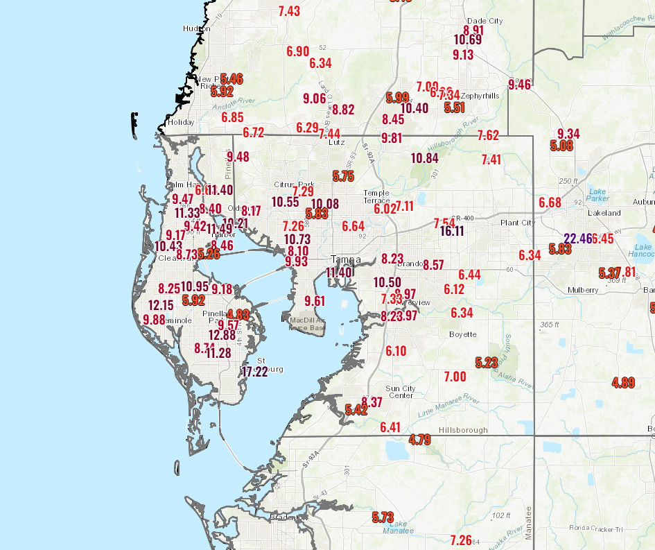
Relentless rain is pounding the Tampa metro area and now spreading north and east across the Florida Peninsula. Totals for today have been up to 17 inches in St. Petersburg and over 10 inches around much of Tampa.
Tampa area rain totals so far today. (NOAA NWS)
There’s still a good deal more rain to come though hopefully the pace will slow somewhat. A flash flood emergency is in effect in Tampa. Catastrophic flooding is possible from the rainfall. This may not be the last flash flood emergency we see this evening, with torrential rain working northeast on I-4 toward Orlando and Deltona.
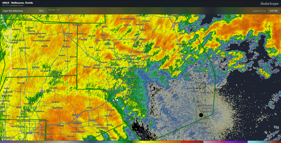
Torrential rain, serious flash flooding and strong winds are headed to Orlando soon. (RadarScope)
Several inches of rain will fall in a short time here, and severe flash flooding may occur. Thankfully, the tornado threat has pushed offshore for now, and though an isolated tornado can’t be ruled out there should not be the ridiculous pace we saw earlier today. The damage in eastern Florida from tornadoes is going to be more significant than we typically see in a tropical system. Why this storm went ballistic whereas other do not is a complex topic to get into but perhaps one we can touch on during the offseason.
Next update will be in the morning sometime. Wishing all the best in Florida.