The Atlantic remains quiet for the foreseeable future.
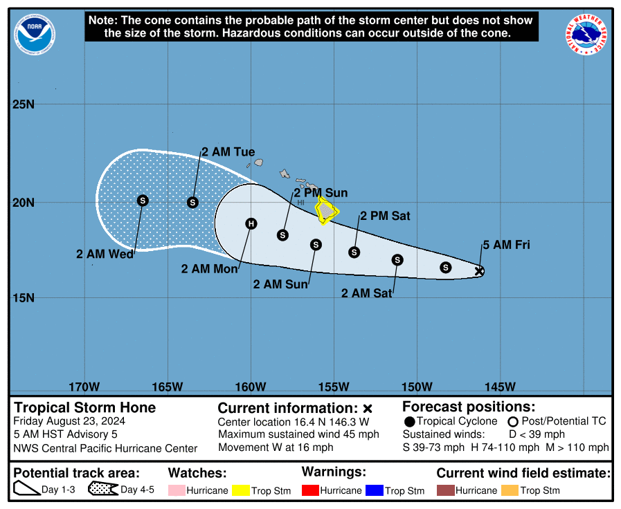
Tropical Storm Hone will bring heavy rain and strong winds to parts of Hawaii later this week.
A Tropical Storm Watch is in effect for the Big Island.
Thank you to our Friday featured sponsor: EnhanceCo!
Searching for signs of life in the Atlantic
All remains quiet in the Atlantic basin with no signs of any real meaningful activity expected over the next week or two. Odds of any activity on the Euro ensemble for the next 10 days look muted as well.
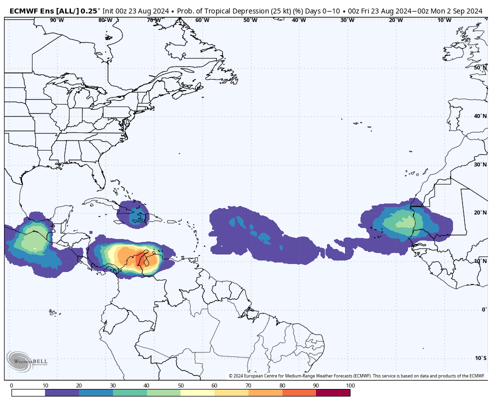
Probability of tropical development from the European ensemble appears to be 10 to 20 percent or less over the next 10 days, which is a very low value from a 51 member ensemble. (Weather Bell)
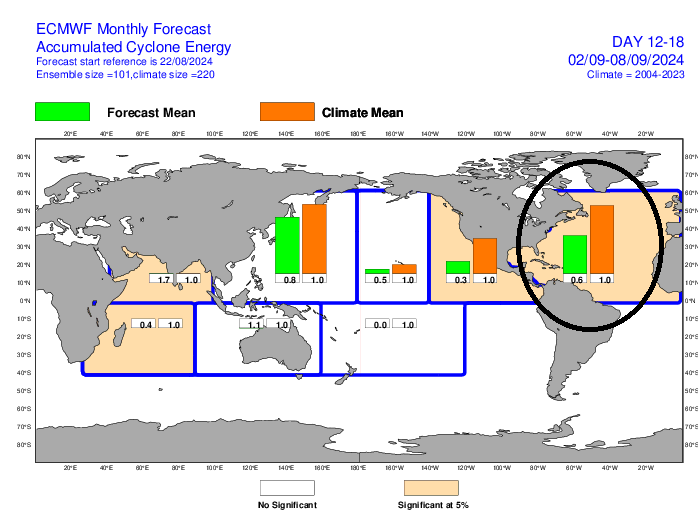
You can ignore what you see off the coast of South America. The only real candidate over the next couple weeks is probably a tropical wave that emerges off Africa around days 9 to 10. But even that seems like a low possibility. Yesterday’s extended range forecast from the European model into the first full week of September shows about half as much ACE as normal, meaning it predicts below average activity through about September 10th, the historical peak date of hurricane season.
Atlantic tropical activity is forecast to be below normal through week 3 from the European model. (ECMWF)
Does this change in weeks 4 and 5? Yes, however it never gets above normal. This argues that conditions will become more favorable for tropical development as September progresses. But it may argue that conditions end up less favorable than were feared coming into the season. At the risk of jinxing things, I’ll stop there. From an accumulated cyclone energy standpoint, we are now 18 percent of the way through hurricane season. If we get to September 2nd (10 days) with nothing, we’ll be 34 percent of the way there. Historically, we ramp up quickly now. That we’re quiet through the next 7 days or more is great news.
Honing in on Hawaii
Meanwhile, the Pacific continues to pick up the slack (though you can see from the chart above that this may not continue). Hurricane Gilma continues on a road to nowhere, though its remnants could impact Hawaii next week. Behind Gilma, a new storm should form this weekend or early next week. But of more consequence is Tropical Storm Hone (Pronounce HOH-neh). A Tropical Storm Watch has been issued for the Big Island of Hawaii.
Hone is expected to pass just south of the Big Island on Saturday night as a strong tropical storm. (NOAA NHC)
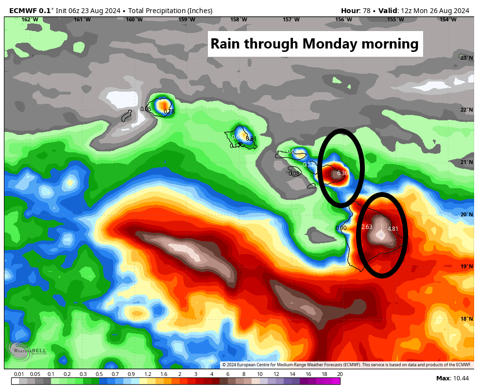
Impacts to Hawaii will be mixed. Storms aren’t as straightforward in Hawaii as they can be at times in the Mainland of the U.S. Terrain plays a huge role in who sees what. For example, with Hone passing south of Hawaii, there will be substantial upslope rain with winds out of the southeast that occurs on the southeast facing slopes of Mauna Loa and Mauna Kea. Rain will likely expand into other islands as well, but that will also be locally influenced by terrain. The strongest winds from Hone will occur on the downslope or western facing slopes and through passes. Winds could gust as high as 40 to 60 mph for folks.
Rain in Hawaii from Hone will be highest on the southeast facing slopes of the Big Island and Maui with slightly lesser amounts to the west. (Weather Bell)
Hone will continue off to the west, and then we’ll see what happens with Gilma’s remnants next week.
Friday featured sponsor: EnhanceCo
Thank you to EnhanceCo and all our sponsors for their support of The Eyewall this season!
EnhanceCo is a small family-owned company which operates both domestically and internationally to provide internal corrosion-related consulting and field services, along with customized monitoring equipment for the energy , chemical and industrial/commercial water and data center industries EnhanceCo has 40 years of field experience and recognized expertise. EnhanceCo can recognize problem areas and to assist you in developing cost-effective solutions. Their services include system surveys, troubleshooting, vendor oversight, enhancement and construction of new or legacy internal corrosion programs, training, and many other methods of assisting you in your quest for the most efficient, sustainable and proactive programs for your assets. You can visit their website at www.enhanceco.net or contact Eric Smith at 281-499-4426.
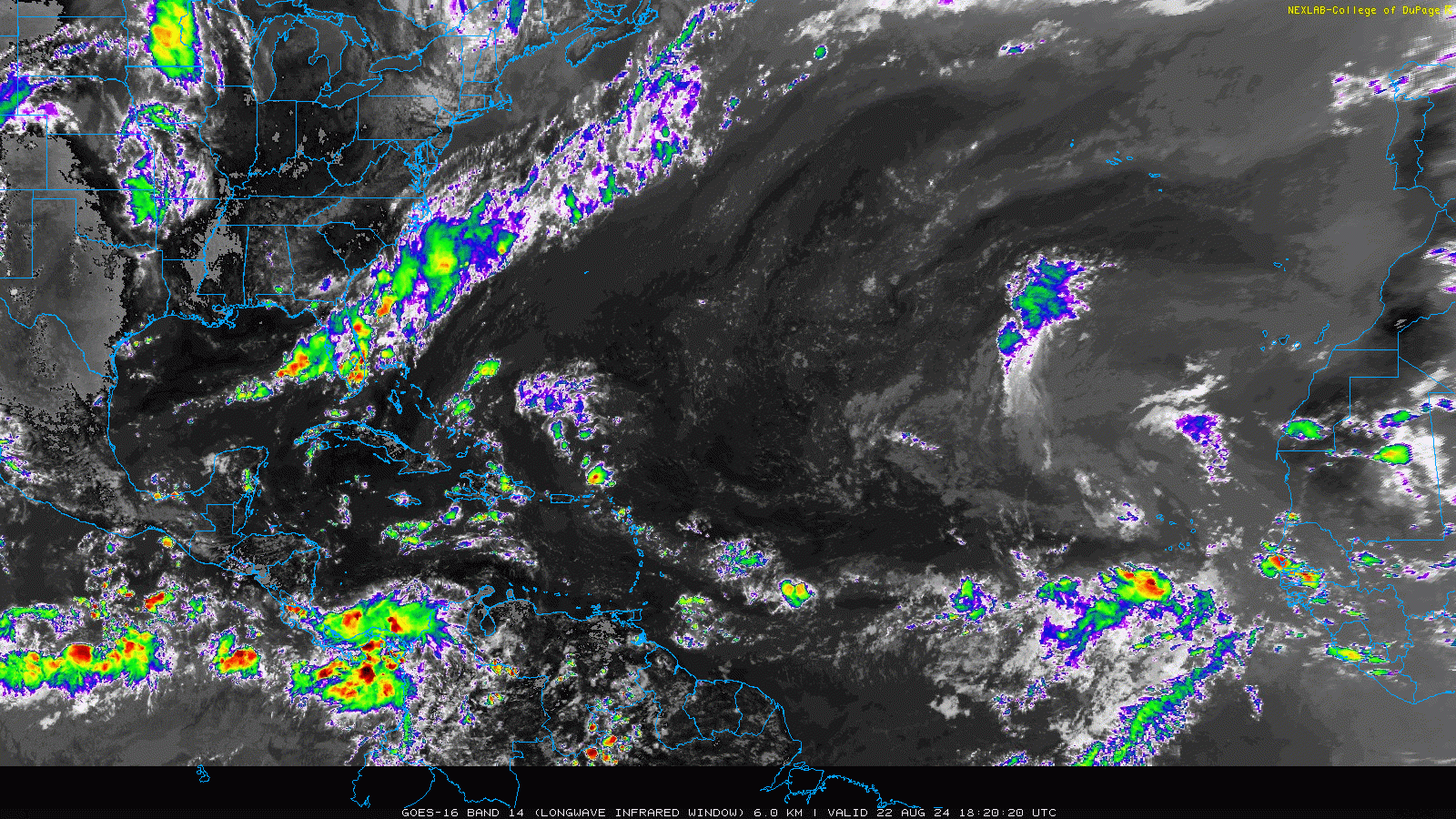
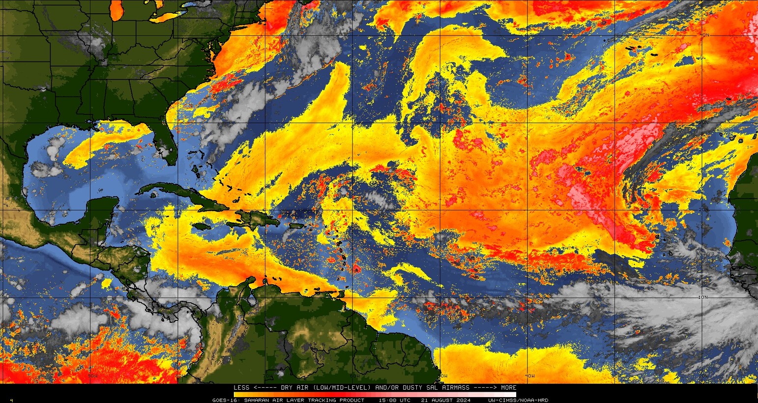
The satellite imagery over the Atlantic Basin today looks more like something from June than late August. (College of DuPage)
If you asked me to tell you the date of the satellite image above without knowing anything about it, I would easily tell you probably June or early July. Or later in October or something. The only real tell might be that my eyes are trained to discern Saharan dust off of Africa in the infrared band of the satellite. But whatever it is, the takeaway here is that this is about as quiet as you will ever see a late August satellite image look over the Atlantic. There are currently no areas of interest. And when you look at the very latest 12z European model for the next 3 weeks, there are only scattered pockets of “noise” showing up in the forecast, and no real specific tropical wave to focus in on.
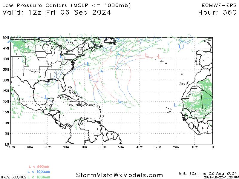
European ensemble forecast of low pressure centers over the next 15 days shows very little signal and only a modest amount of noise. (StormVista)
And within that noise, there is little signal to really pick up on. Maybe there’s a wave late that’s a recurve candidate out to sea? That’s about all I see here. That isn’t to say that there will be no systems to track over the next 2 weeks, it’s just that there isn’t exactly a strong signal for anything in particular right now. Which is unfathomable for late August in any year, let alone this one.
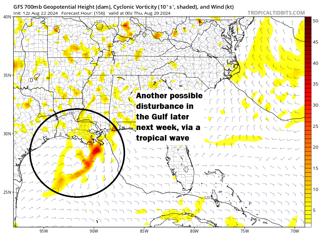
Now, I will say it’s wise to keep an eye on the Gulf next week. There is one little disturbance that comes ashore in Texas on Monday, ushering in a better chance of rainfall for much of the southern and eastern part of the (increasingly dry) state. Beyond that, I have seen the GFS model try to latch onto a tropical wave currently over Hispaniola. It never really develops it, but it does try to bring it into Texas or Louisiana later next week.
The GFS model shows a tropical wave approaching Texas or Louisiana later next week, unlikely to develop but worth watching. (Tropical Tidbits)
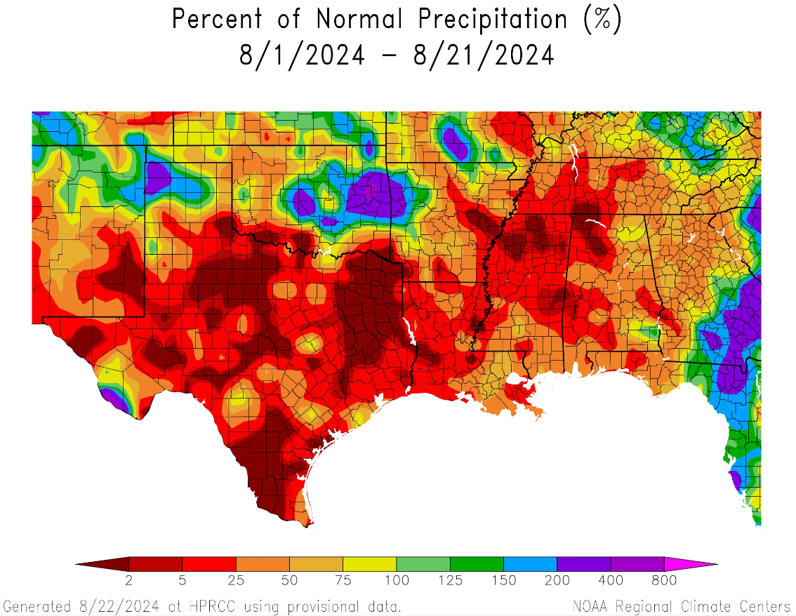
Do I agree with this? No. But any meteorologist worth their salt would not discount a tropical wave in the Gulf in late August. So it should be babysat, but I wouldn’t be too worried right now. At the least, hopefully all this opens up some rain risks in these areas. Since the calendar flipped to August, rain has been tough to come back in all of Texas and all of Louisiana. Houston is running about 20 percent of normal rainfall this month, while much of East Texas is less than 5 percent of normal. Louisiana is less the half of normal as well. Rain would be welcome.
Rainfall has been almost non-existent this month in much of Texas and Louisiana — and points northeast. (High Plains Regional Climate Center)
We’ll keep an eye on this as it evolves.
The Pacific is busy
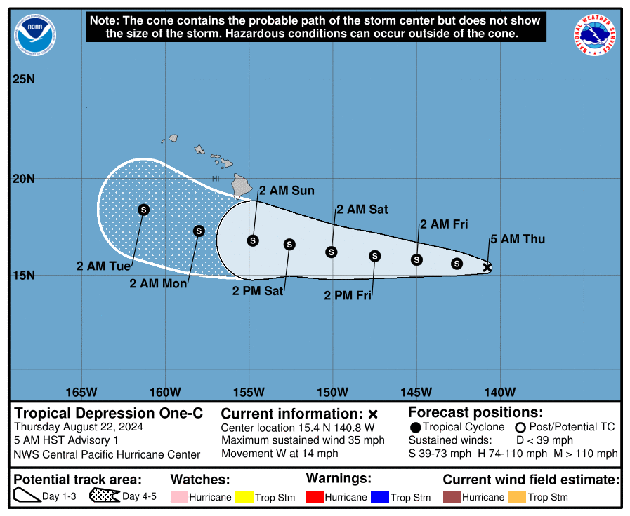
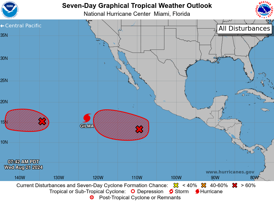
While the Atlantic is on hiatus, the Pacific is busy. Hurricane Gilma is now a strong category 3 storm, heading for nowhere. Another disturbance behind Gilma is likely to form. And just this afternoon, we have Tropical Depression 1C in the central Pacific.
Tropical Depression 1C is currently expected to pass south of Hawaii. (NOAA NHC)
This one is not expected to become a significant storm, but it is expected to become a tropical storm as it passes south of Hawaii. Impacts to the islands may include heavy rainfall and gusty winds by Sunday or Monday, especially on the Big Islands, but it’s a little too soon to say much more than that at this point. We’ll keep an eye on this one as well.
Coming into this hurricane season, there were breathless forecasts calling for anywhere from 20 to even 30 named storms from some folks. Government forecasts were more conservative but even they were the most active we’ve ever seen from NOAA. Colorado State, too. So, as we sit here on August 21st with next to nothing showing up in modeling for the next 7 to 10 days, it’s reasonable for the general public to ask questions about those forecasts.
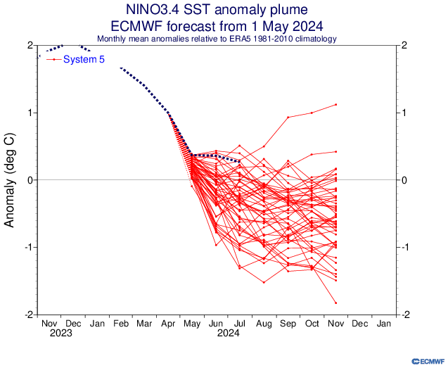
One of our potential fail modes was if La Niña developed too slowly. Indeed, the pace of the La Niña development this season, while uneven, has generally lagged the strongest projections. At least officially. Here’s a look at the May 1st European model ensemble outlook for the ENSO 3.4 region, the box of temperatures we look at to basically designate La Niña or El Niño.
The spring forecasts for La Niña have (to this point) turned out a little too aggressive. But directionally, they’ve been fairly correct. (ECMWF)
We should begin closing in on an official La Niña designation in the next month or two, but we aren’t quite there yet. Keep in mind, this is by no means a perfect representation of things, and sometimes the atmosphere can behave more Niña-like even if we aren’t officially there yet. But this has not developed as aggressively as some modeling showed in developing in spring.
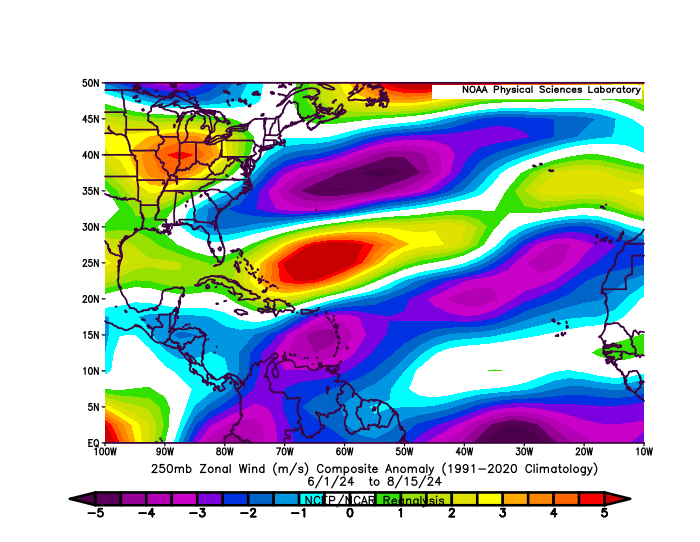
So, at a very, very distant level, perhaps that has something to do with it. Michael Lowry, in his excellent daily newsletter pointed out yesterday that wind shear has become almost too extremely reversed this month. Typically, during a La Niña, there is more of an easterly component from the wind that counteracts or reduces the usual west to east winds that can cause shear in the Atlantic, detrimental to hurricane development. In a twist of fate, there’s so much of an easterly component to the upper level winds this year that it’s actually causing easterly shear. Otherwise, we might be a good bit busier at the moment. If you look at the basin as a whole since June 1st, winds have been generally lighter than usual in the Caribbean and much of the Atlantic and a bit stronger than usual in the southwest Atlantic and in the Gulf.
Upper-level winds have been generally below average this summer in some key tropical development areas. As such, we’ve accumulated some bang for our buck this season so far. (NOAA PSL)
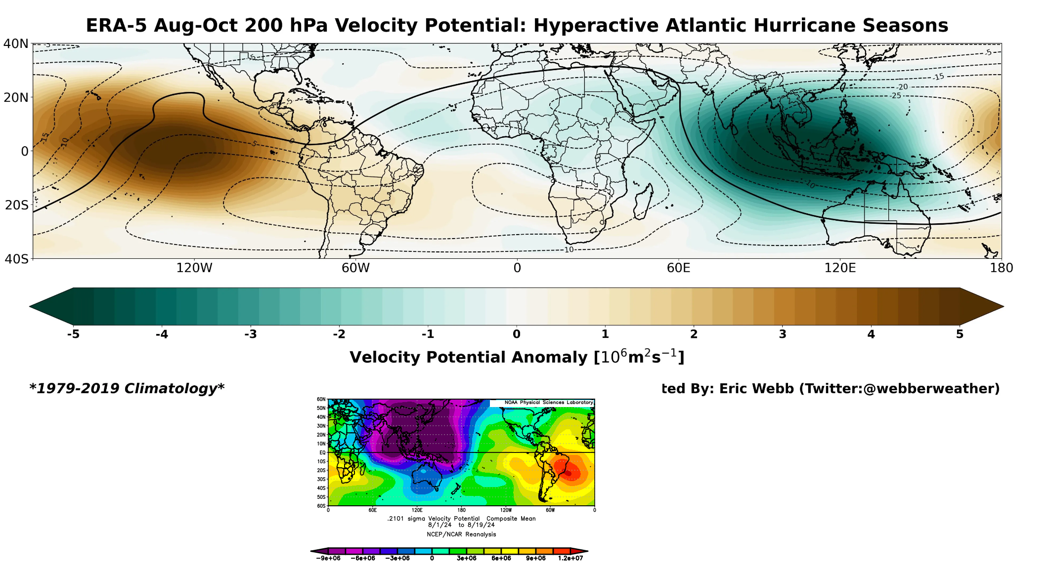
Let’s dig a little deeper. One thing that’s legitimately fascinating to me right now is what’s happening in terms of upper level background support in the atmosphere. Using a variable known as velocity potential, we can see that in historically active hurricane seasons, you would expect to see a significant area of rising air in the Indian Ocean, bleeding a bit into Africa (green on the top map below). Opposite to that, there would be a significant area of sinking air in the Eastern Pacific Ocean (brown colors below). Why is this important? In order to generate an active outbreak of storms in the Atlantic, you need disturbances tracking across Africa, which tend to get supported by rising air over and just east of there. You also prefer to see the Pacific undergoing sinking air, as a way to keep it from ‘robbing’ the favorable conditions for storminess. Sinking air suppresses thunderstorm development and tends to dry out the air a bit.
So what’s going on right now? So far this August, we’ve actually *had* what we would expect from a hyperactive season in the Indian Ocean. Click to enlarge the image below.
A comparison of velocity potential in hyperactive seasons (top) vs so far this August (bottom). While we have what we’d expect for a period of high activity, something is out of phase inhibiting things. (Eric Webb/NOAA)
We have a ton of rising air in the Indian Ocean this month (purple & blue on the bottom map above). We have that extending into Africa. This is what you’d expect for a busy season. Where it differs, however is exactly where the sinking air (red/orange in the bottom panel above) is located. In a typical hyperactive season, this is focused over the Eastern Pacific. This year, it’s focused on the eastern side of South America. This is Matt speculating wildly here, but: I suspect that we’re seeing the right ingredients in place, but I think we are seeing them out of phase. The rising air in the Indian Ocean extends deeper into the Pacific, and there is more of a neutral Eastern Pacific signal right now. This is helping boost activity in the Pacific.
Today’s 7 day outlook in the Pacific includes Hurricane Gilma and two other disturbances that are likely to organize. (NOAA NHC)
The problem with the tropics is that support like this generally moves from west to east, and eventually this will change. So the quiet now may change in a very, very quick way come September when this (presumably) shifts. For now, the Atlantic is still seeing rampant dust and a slightly displaced intertropical convergence zone (ITCZ) which is sending disturbances off Africa too far north and into dust. So they die off earlier. This too will change.
Widespread Saharan dust (pink, red, orange) extends across much of the Atlantic, and as disturbances are coming off farther north than usual, they’re hitting the dust head on. (University of Wisconsin CIMSS)
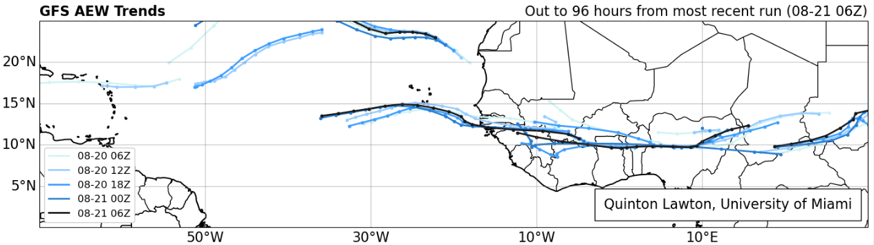
In fact, if you look at the forecast of African Easterly Waves (AEWs) from the latest GFS model, you can see this southward shift approaching heading into the next week or two. The waves lined up over Africa are about 5 to 10 degrees farther south in latitude about 4 days from now, which means they will emerge farther south and in more of a traditional area less exposed to Saharan dust in late August and September.
Tropical waves are going to begin emerging off Africa farther south than they have been recently, which should ultimately lead to a boost in activity heading into September. (Quinton Lawton, University of Miami)
So, yes, things are almost certainly going to pick up soon.
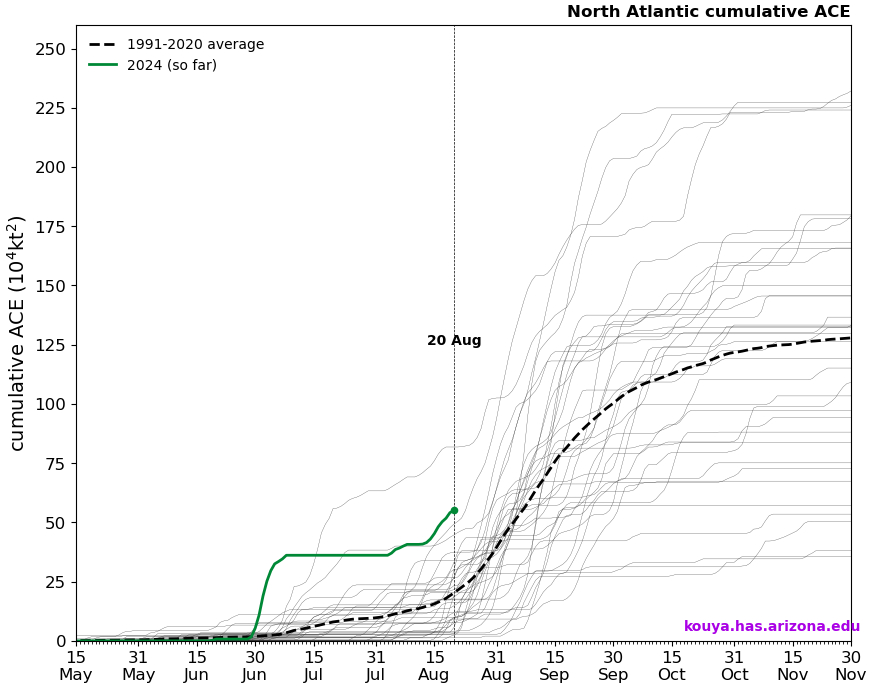
Despite perception, this season’s current accumulated cyclone energy is running nearly 3 times higher than usual! We’ve amassed as much ACE so far this season as we’d typically see by the peak day of hurricane season (September 10th). We’ve done this on the backs of only five storms so far, three of which have been hurricanes, and one of which (Beryl) smashed early season records in the Caribbean and Atlantic.
Accumulated cyclone energy (ACE) this season has been historically high despite the perceived slow start to the season. (Kim Wood/University of Arizona)
So despite the perception that this season has been slow to start, it actually has not been. In fact, 2024 is in rarefied air in terms of ACE to date. This perception might have to do with storm inflation, or the idea that we are naming more storms today than we did, say, 20 or 30 years ago. In 2020, basically the benchmark for recent historically active seasons, today marked the formation date for Hurricane Laura, the 12th named storm of the season. Here we are in 2024 sitting at five, and it’s no wonder the perception is skewed. Despite having more than twice as many storms to this point in 2020, we only had half the ACE (26 vs. 55 this year). 2020 kept churning out mostly sloppy storms until Laura, and then things got nasty. We’ve had three legitimate hurricanes this year and only about one “throwaway” storm (Chris). The takeaway message here is that: We can make up ground in September very, very fast. Very fast.
So, no, this season’s extremely active hurricane seasons have not been a bust so far, and they probably won’t end up being a bust overall. We’ve had a “bang for our buck” season so far with quality storms over quantity as, say, in 2020. And while we are in a lull now, the setup is probably going to change in 7 to 10 days to allow things to crank up in September. Never call it a bust. If it is one, we can discuss why in November. For now, use this quiet time to review your hurricane preparedness plans and supply kits. And stay tuned here for the latest through September.
Ernesto will exit out to sea tonight and tomorrow, brushing southern Newfoundland with some impacts on the way out.
The Atlantic looks quiet through early next week.
If we want to scope out trouble that isn’t showing up on models, we’ll watch a Gulf disturbance this weekend and early next week; unlikely to develop but will bring some welcome rain chances back to Texas.
Ernesto finds the exit ramp
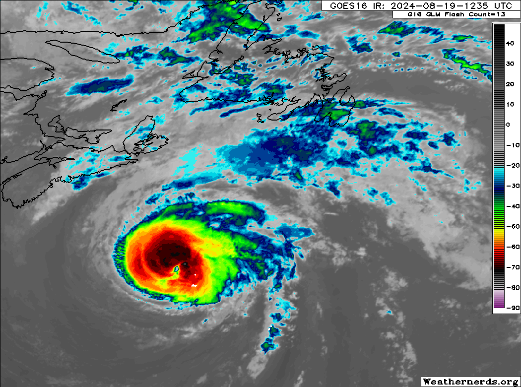
After impacting Bermuda and sending a bunch of rough surf toward the Atlantic coast of the U.S. and Canada, Hurricane Ernesto is on the way out the door today.
Hurricane Ernesto is accelerating off to the northeast, while flinging clouds and perhaps some modest impacts to southeastern Newfoundland. (Weathernerds.org)
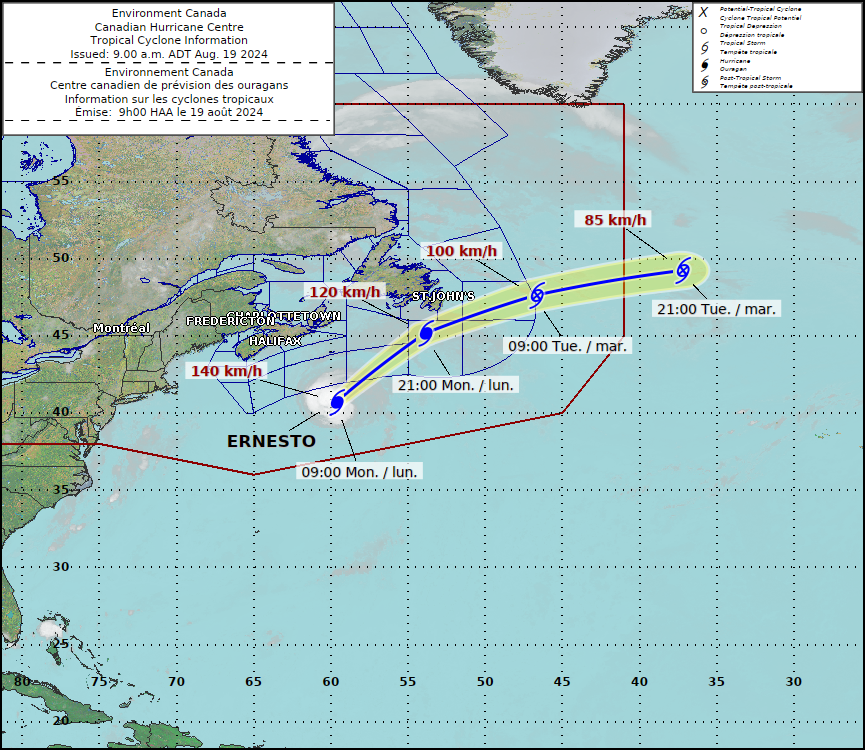
Ernesto is now moving northeast at 28 mph and taking on that “look” of a storm in transition from tropical system to post-tropical low pressure. Winds are 90 mph with Ernesto, and the wind field remains large, with tropical storm force winds expanding out 220 miles from the center. As Ernesto makes its closest pass to Newfoundland tonight, wind, rain, and rough seas will likely impact the Avalon Peninsula.
Ernesto’s track will bring it close to the Avalon Peninsula of Newfoundland tonight before it exits out to sea. (Canadian Hurricane Centre)
With Ernesto moving along quickly, conditions should deteriorate there quickly tonight, then improve quickly tomorrow. By tomorrow night, Ernesto should be full extratropical/post-tropical and racing east-northeast across the Atlantic. And that closes the book on the fifth storm of 2024.
A lull for a moment
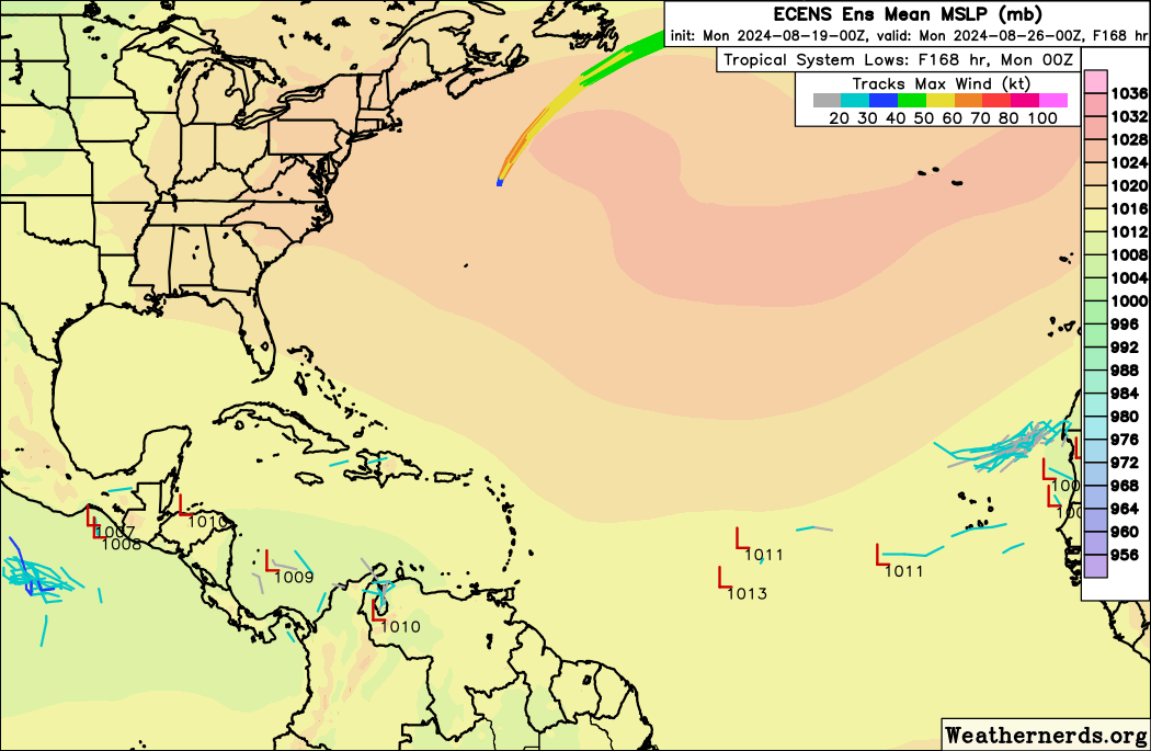
The Atlantic basin will shut down post-Ernesto for a moment or two. Or three. Who knows. Tropical activity over the next 7 days is expected to be basically non-existent.
A plot of European ensemble tropical systems over the next 7 days shows virtually nothing after Ernesto. (Weathernerds.org)
How long this lull lasts is tough to say. We’ll dive more into the context of all this and how this season stacks up vs past seasons a little later this week (and key reasons to not write it off as a “bust” in mid-August). For now, I don’t see anything really of note out there over the next 7 to 10 days. I do believe conditions will shift more favorable for activity as the calendar flips to September. But that’s an average confidence feeling right now.
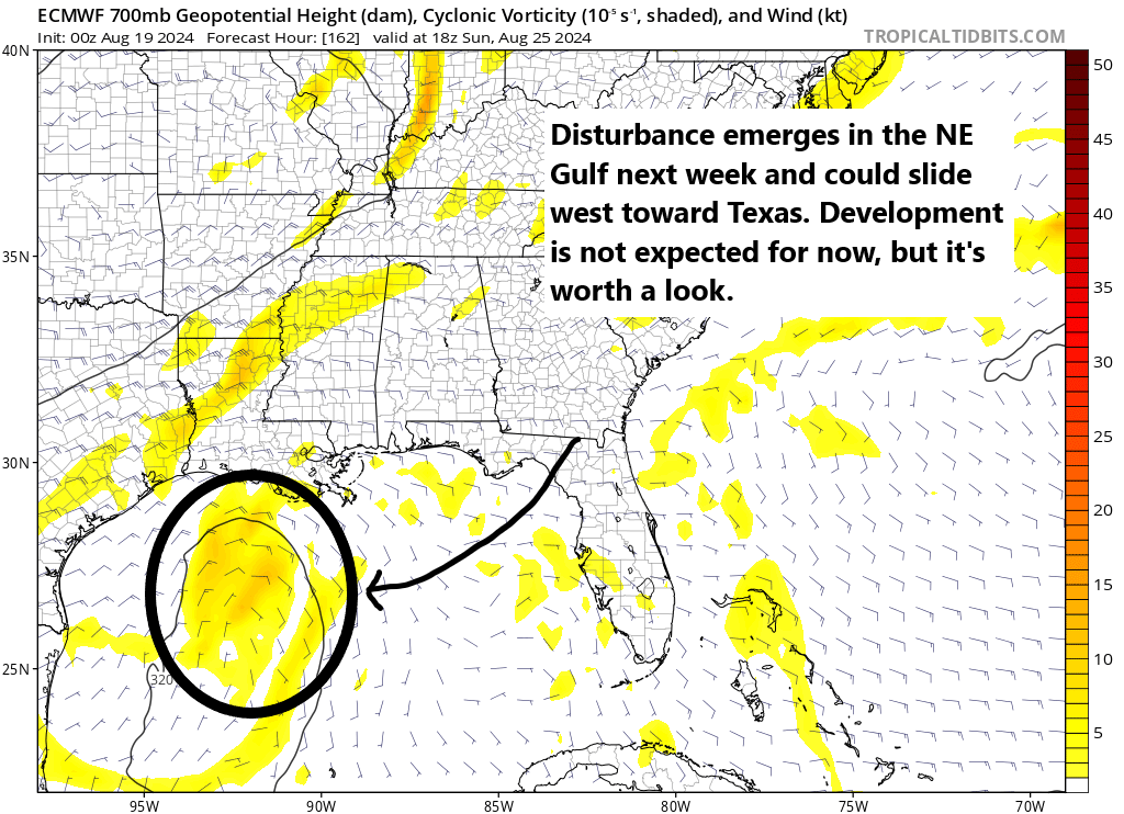
If we want to dig for trouble that could surprise us, we could maybe look in the Gulf this weekend or next week. It appears that a disturbance is going to swing in either off the Atlantic or from inland thunderstorms across the Southeast and into the northeast Gulf of Mexico by this weekend. From there it will follow its way around the periphery of a Central Plains ridge of high pressure across the Gulf toward Texas.
Mid-level disturbance may be worth watching as it swings across the Gulf this weekend or early next week. Not expected to develop, but it should bring increasing rain chances to Texas next week. (Tropical Tidbits)
Again, we’re looking for surprise trouble here, which is to say that no model currently develops this at all. And that’s the most likely outcome. But, we’ll keep tabs on it just in case. Regardless, this will probably bring an increase in rain chances to Texas next week, which has gone fairly dry this month. Most rain will be welcome.
But aside from that, I think we’re on a pre-peak break in the Atlantic through early next week. We’ll take it.