Thanks to Eric for covering yesterday. Much like we do with Space City Weather, he and I will split duties, though I’ll spearhead most of this site, as he does with Space City Weather. Today we’ll discuss more about why the GFS model is probably getting the day 10+ range wrong. We’ll also tackle part 3 of our seasonal outlook which discusses water temperatures in the Atlantic.
One-sentence summary
The tropics are quiet, and we continue to believe that what is shown on the GFS model late in its forecast period is not a serious concern.
Happening now: Not too much!
All is quiet across the tropics this morning with no disturbances of note. The main weather feature right now is an upper low near New England that has been responsible for directing Canadian wildfire smoke into the East.
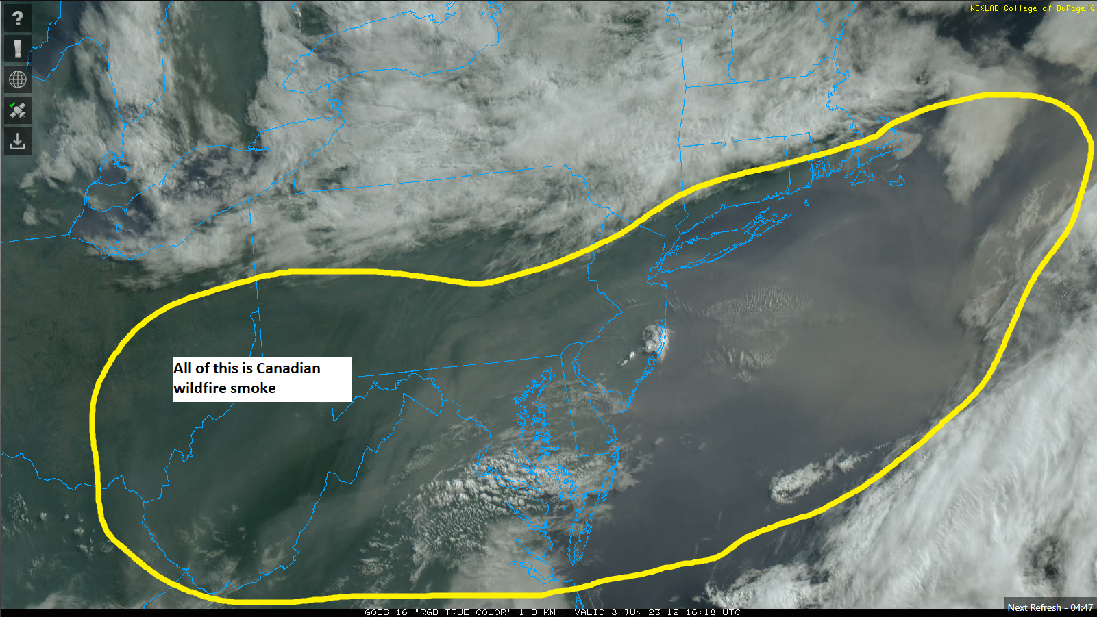
While this is not directly related to tropical weather, it was noteworthy to watch the squashing of fair weather clouds as smoke moved into some locations in the Northeast. Reminiscent of how Saharan dust can help inhibit tropical systems. We’ll touch more on the dust situation next week.
The medium range (days 6-10): Nothing yet
We continue to see quiet conditions likely to continue through about day 10, so there is not much to discuss here.
Fantasyland (beyond day 10): The GFS is probably still wrong
We’ve talked about this for a few days now, but we also know that when something shows something adverse consistently, it can spark some concerns. Despite the fact that the GFS operational model has shown a substantial storm for multiple straight runs in the day 12 to 16 timeframe, we remain fairly convicted that it’s really nothing to worry over. Besides the fact that the GFS frequently gravitates toward “scareicanes” in the Gulf this time of year, Eric also touched on the ensembles not supporting it yesterday. That remains true today.
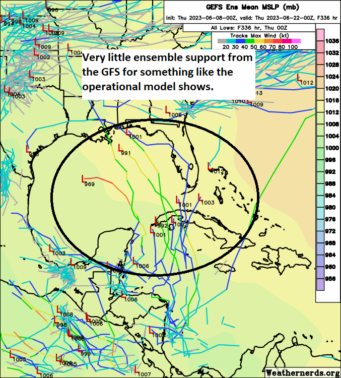
Operational model runs are really just that: One run of one model. It’s deterministic. This is what the model thinks is going to happen, and that’s that. Ensemble guidance is much more nuanced. You take those models, like the GFS or ECMWF (the Euro) and run it 30 to 50 different times with tweaks to how the model is initialized, the starting point that it bases the rest of the forecast on. By doing this, you get a more realistic set of possible outcomes than just what one deterministic model shows. And in the case of this rogue GFS model storm, the ensemble guidance offers little additional support for something like the operational model shows. And the European model? It shows nothing at all.
That said, there’s good reason to think that something may be afoot late. I touched on this a little back on Monday. But the overall background pattern is going to become a bit more supportive for rising air in the Atlantic.
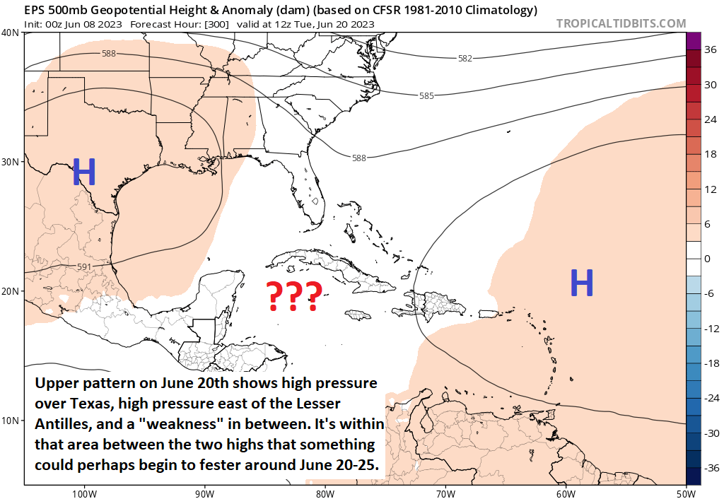
Couple that with an upper level pattern that shows a mean trough (dip in the jet stream) over the Southeast, eastern Gulf, and western Caribbean, and that argues that, broadly, we look more favorable for tropical development toward the final 7 to 10 days of June. But probably not like what the GFS operational model is showing at the moment. We’ll see if this can roll forward as we move into next week.
The 2023 seasonal outlook Part 3: Atlantic Ocean water temperatures
On Tuesday we discussed what the outlooks were for the 2023 Atlantic hurricane season. Yesterday we broke down El Niño. Today, let’s look at the Atlantic Ocean. With the exception of the northeast Gulf of Mexico, the area off the immediate Southeast and Mid Atlantic coasts, and a chunk of the subtropical Atlantic, the entire basin is running hot, with widespread water temperature anomalies that are above normal.
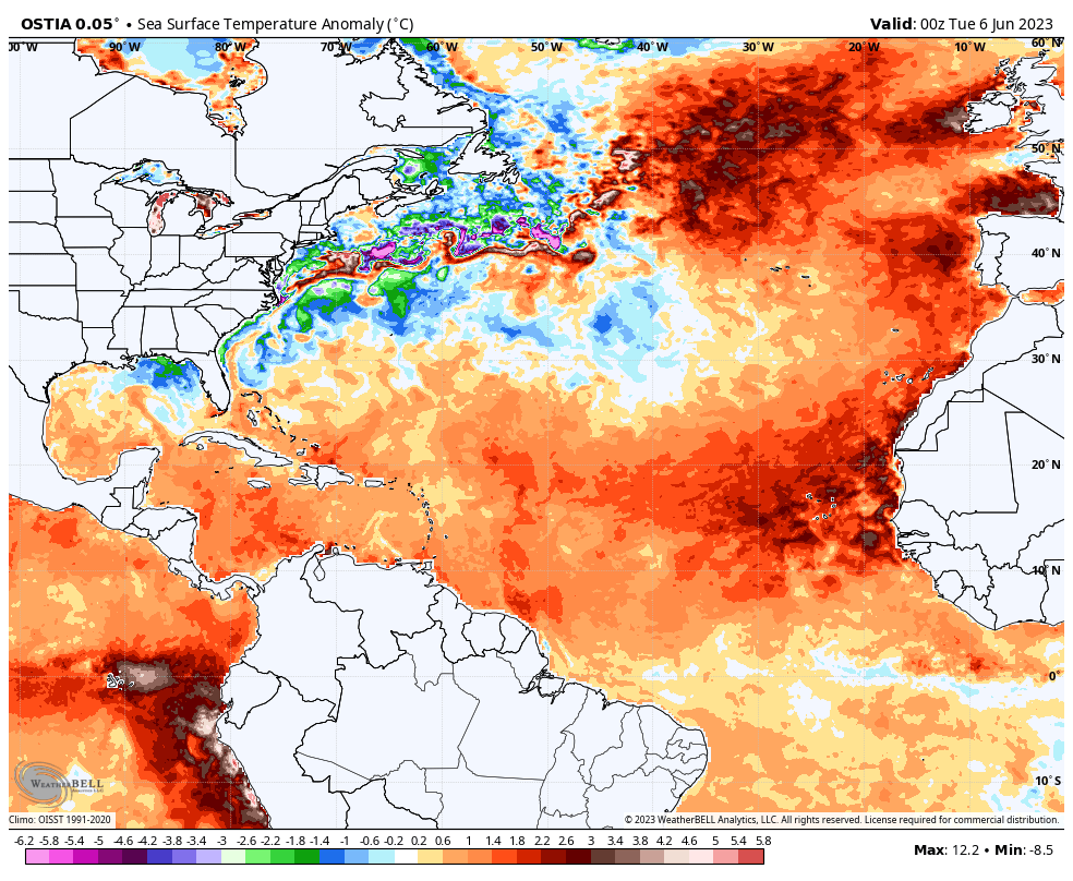
As Michael Lowry pointed out in his (always excellent) daily tropical newsletter yesterday, the eastern portion of the Atlantic is at its warmest levels on record for this time of year, and it is not really even close. Obviously, this is important. But just how important? If you look at page 9 of Colorado State University’s seasonal hurricane outlook from this month, you’ll find that eastern Atlantic SSTs have a nearly 0.6 correlation to seasonal accumulated cyclone energy (ACE). In simple terms: A warm eastern Atlantic this time of year typically produces active hurricane seasons.
It’s tough to find a true analog to this year though because a.) this is the record warmest and b.) no previous upper-end warm eastern Atlantic basin temperatures coincided with an El Niño event in the Pacific. But, looking at the Atlantic in a box, if you took the five warmest years outlined in CSU’s forecast behind 2023, you averaged 23 named storms. Big yikes. Compare this to what we said about El Niño yesterday, which averaged 9 storms. Those goalposts are wide enough for <insert the name of a football kicker who has undoubtedly made you angry at some point> to never miss. No one ever got into weather forecasting because it was easy.
So El Niño implies a weak hurricane season, while the current water temperature situation in the Atlantic implies an extremely active season. This is a tug of war and a half, and one of the most fascinating seasonal forecasting challenges I’ve ever seen. Tomorrow we’ll talk about some risks and tie a ribbon on all this.
You guys are awesome!!
Great site. Love the fact we can get real hurricane news and not melodrama. Good like with forecasting hot water verses El Niño.
This is why I added The Eyewall to my morning reading. Eric and Matt are a one-two punch for good commentary, and this content read more like a mystery (which of course, weather is) more than a forecast. Well done!
You leave us with a cliffhanger! Tune in tomorrow when Matt says…..?
Fascinating commentary and an inside baseball look at forecasting in general….. Thanks
Absolutely great stuff! 💕💕💕
Tysm 😎