One-sentence summary
Philippe will brush the northern Antilles on its way out to sea this week, while the Atlantic temporarily calms down.
Tropical outlook: Philippe takes control, a brief break follows
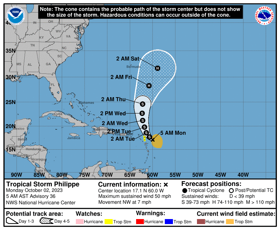
Over the weekend, we watched the ballet between Rina and Philippe take place over the open Atlantic. As expected, Philippe won. These are not necessarily easy interactions to forecast, but truth be told, I think modeling did about as well as you could hope! Philippe basically sagged south as expected, while Rina overshot it to the north, and here we are this morning with the remnants of Rina to the north and Philippe to the south, readying to turn north and eventually out to sea.
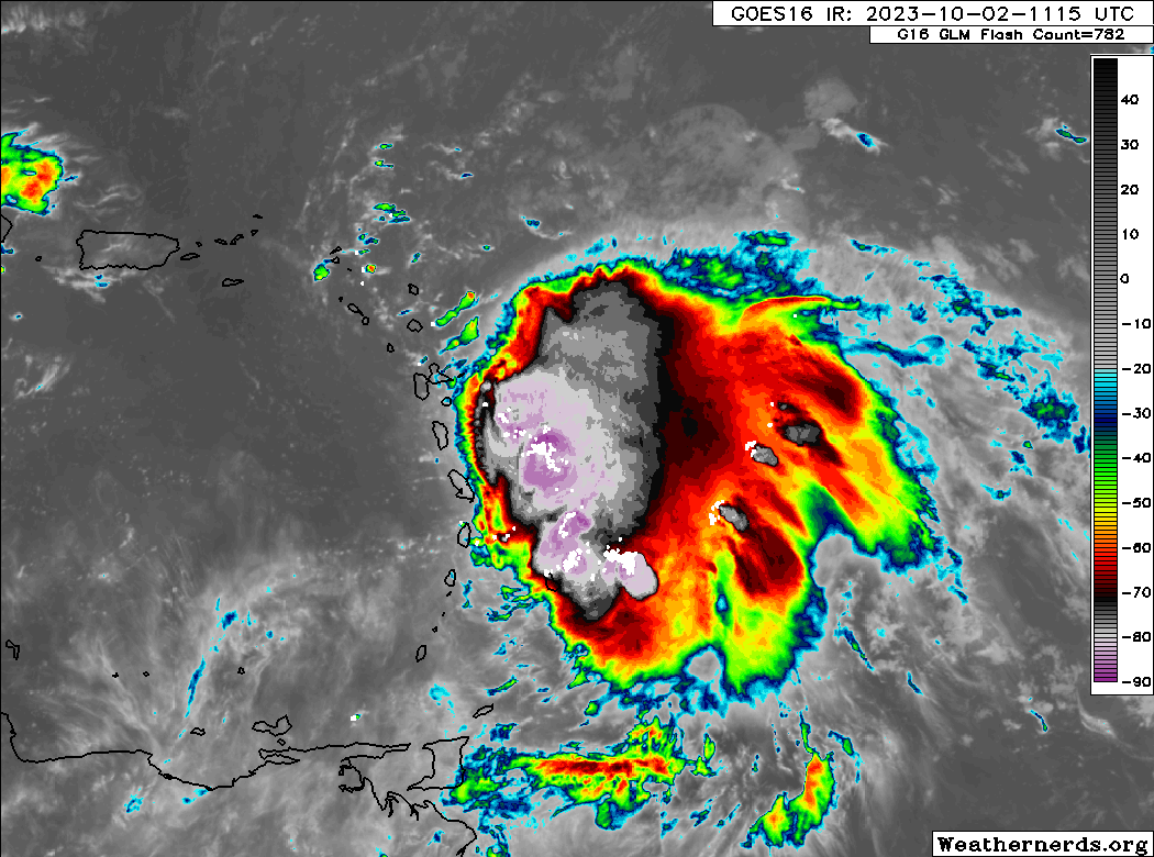
That being said, before Philippe exits, it may brush some of the Lesser Antilles with some tropical storm conditions. Hence, Tropical Storm Watches are posted for Antigua and Barbuda, although judging by the satellite imagery above pockets of tropical storm conditions are possible for Martinique north through Anguilla. Philippe should creep northwest and then turn north over the next few days. It will begin to accelerate northward back into the open Atlantic later this week. There is a chance it will become our next hurricane as it does so. The good news is that it should not impact land beyond these modest impacts in the islands.
What to watch next: Caribbean & Gulf
We should enter into a period of quiet over the next 5 to 7 days in terms of new development. There’s not much out there on modeling, and the National Hurricane Center has not highlighted any areas to watch at this point either. So, we’ll assume that for this week, it’s Philippe and that’s all.
Now, next week? That’s another story. We expect the Pacific to pick up this week, with a potential developing storm off Mexico. Whether that becomes an issue for Baja next week is another story, as there is a bit of uncertainty around Invest 98E.
That said, the center of action is going to shift to the Eastern Pacific over the next week, and then possibly eventually into the Atlantic basin again, this time focused on the Gulf and Caribbean. Climatologically, this is where you’d be looking in October also. While there is no specific feature I can point to yet, there are growing amounts of noise showing up late in the northwest Caribbean and eastern Gulf. Any system that *can* develop there would probably track north or north-northeast into the southwest Atlantic or eastern half of the Gulf. But we are a long way off from being able to say more than that. This is something we’ll watch this week.
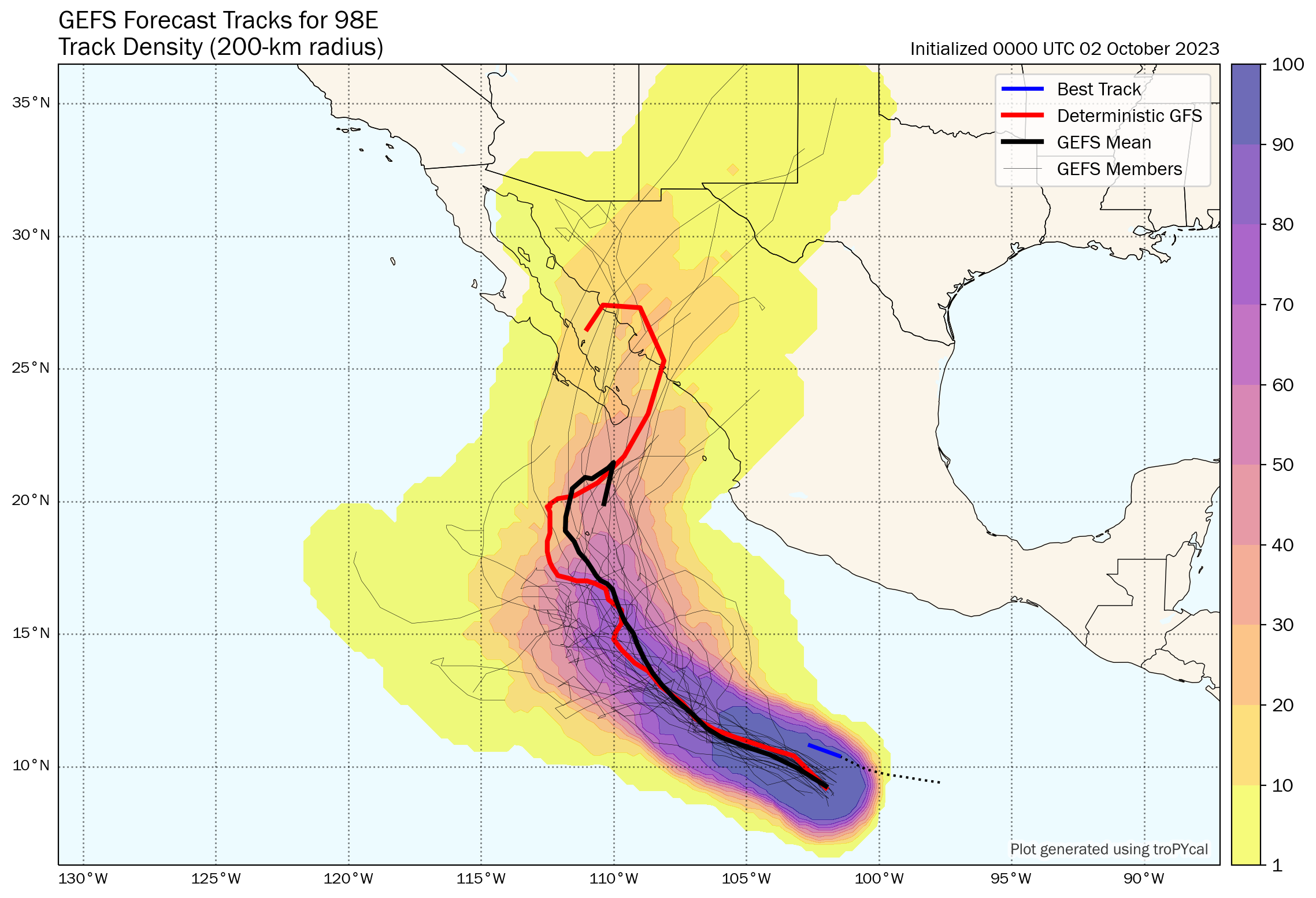
Additionally, it does make sense to keep an eye on Invest 98E in the Pacific, which does have at least some chance of funneling moisture up into Texas next week. In addition to potential impacts in Baja, there’s a slight chance it could deliver moisture into more of Mexico or the U.S. But too many questions remain to get too serious about this one.
U.S. weather update: Texas rain and a sweeping cold front
As we noted last week, as hurricane season calms down, we’ll be transitioning to cover some other noteworthy weather stories. This week, the focus is on Texas and temperatures, as some big weather pattern changes at least temporarily establish themselves.
Midwest warmth & Texas rain
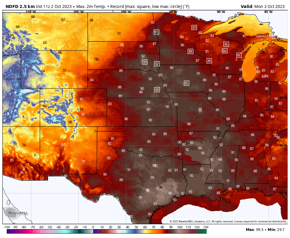
A rather classic autumn weather pattern will establish itself this week, as a storm system establishes in the northern Rockies and ejects out across the northern Plains into Canada. This storm will drag a cold front out of the Rockies, onto the Plains, and then off to the east late this week and weekend. Ahead of the front: Very warm and very humid air builds up. In fact, a number of locations are likely to set record highs today and perhaps tomorrow too, including Des Moines, Fargo, Minneapolis, and Green Bay. Heat warnings are even posted in southwest Ontario in Canada for this weather.
As the front kicks off, showers and storms will begin to pop ahead of it with strong to severe storms possible in eastern New Mexico and west Texas today, particularly just west of Amarillo, Lubbock, and Midland.
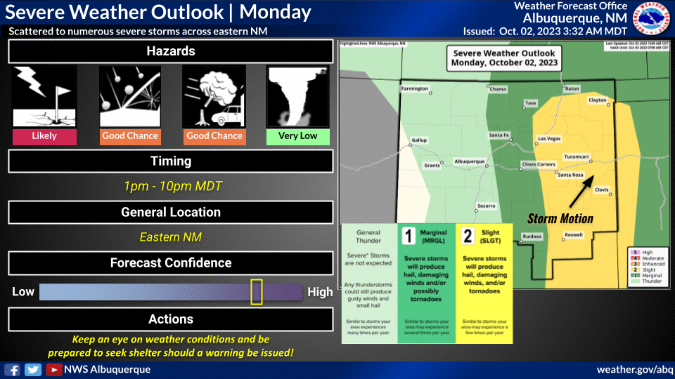
Tornadoes are not expected, but strong winds and hail are possible. Additionally, heavy rainfall will accompany these storms, with a slight (level 2/4) risk for excessive rainfall in eastern New Mexico and west Texas today.
Areas of flash flooding are possible. That threat of heavy rain will expand east into Central Texas as the week progresses, especially on Wednesday and Thursday. The front will finally bring some much needed relief from almost non-stop excessively hot weather in Texas since July. And the rain will be very, very welcome, as much of Texas remains in serious drought.
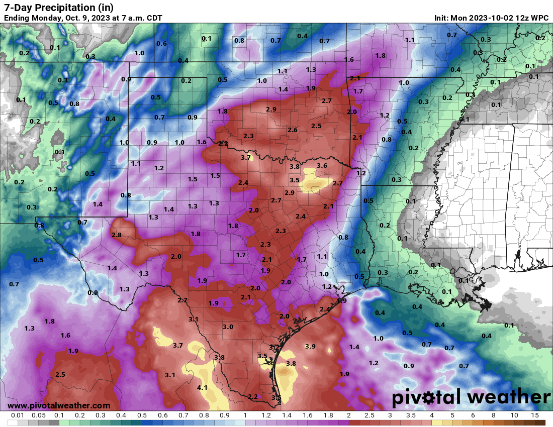
Rain totals in Texas this week will be on the order of 1 to 3 inches, with higher amounts possible, especially in the Coastal Bend and around Corpus Christi, along the border with Mexico back toward Del Rio, and perhaps just east of Dallas.
Lower Mississippi still struggles as saltwater continues creeping toward New Orleans
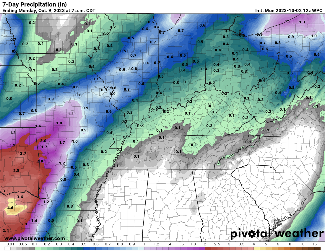
The good news is that a fair bit of rain will fall in the Red River Basin and (to a lesser extent) the Missouri Basin this week, which will eventually end up in the Lower Mississippi. However, this is nowhere near enough. The lack of much rain in the Ohio River Valley is not helping matters either. We discussed this more in depth last week. We’ll keep monitoring things.
Some snows in the Interior West
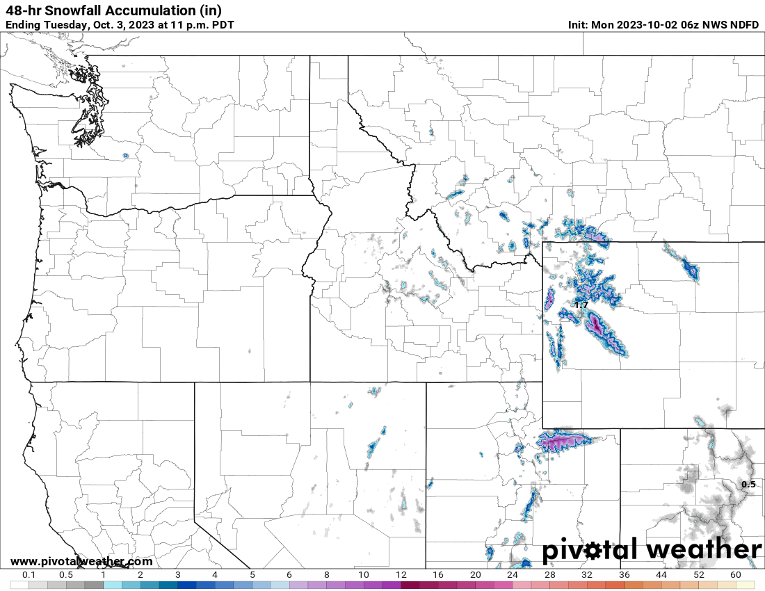
It’s still a bit early for any real severely impactful winter weather, but as is often the case, we are beginning to see snow in the Rockies at times. The winners this week will probably be the western Uintas in Utah (one of the author’s favorite places he’s ever visited), where 4 to 8 inches of snow is expected today and a winter weather advisory is posted. Several ranges in Wyoming will also see a few inches of snow.
A number of places in the interior West and perhaps some in the northern Plains will also see their first frosts and freezes later this week as cooler air comes roaring in. After a long, long hot summer, it’s nice to be able to talk about cool weather again.
Thanks for the great report.
Agreed 😎