We’ve been talking about this shift to a very active weather pattern across the Eastern U.S. for a while now. It’s been mostly in the context of wintry precipitation which has panned out with mixed results overall. Well, the signal now is pretty clearly that wave after wave of storminess is going to lead to a pile up in rain totals over the Southeast at large, specifically from about West Virginia through northern Louisiana. We’ve already seen some flooding in portions of West Virginia recently.
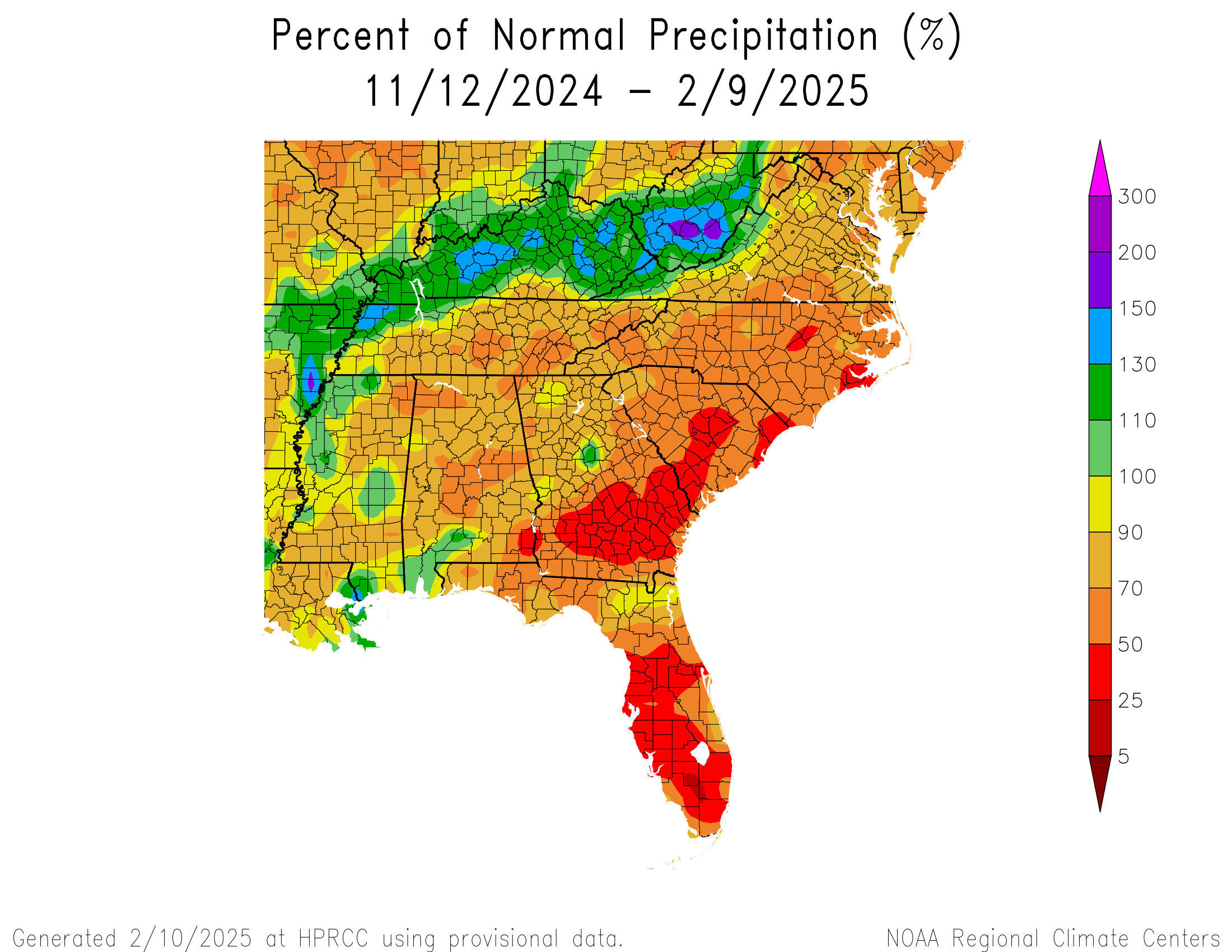
90 day precipitation percentage of normal across the Southeast shows generally dry conditions have ruled. (High Plains Regional Climate Center)
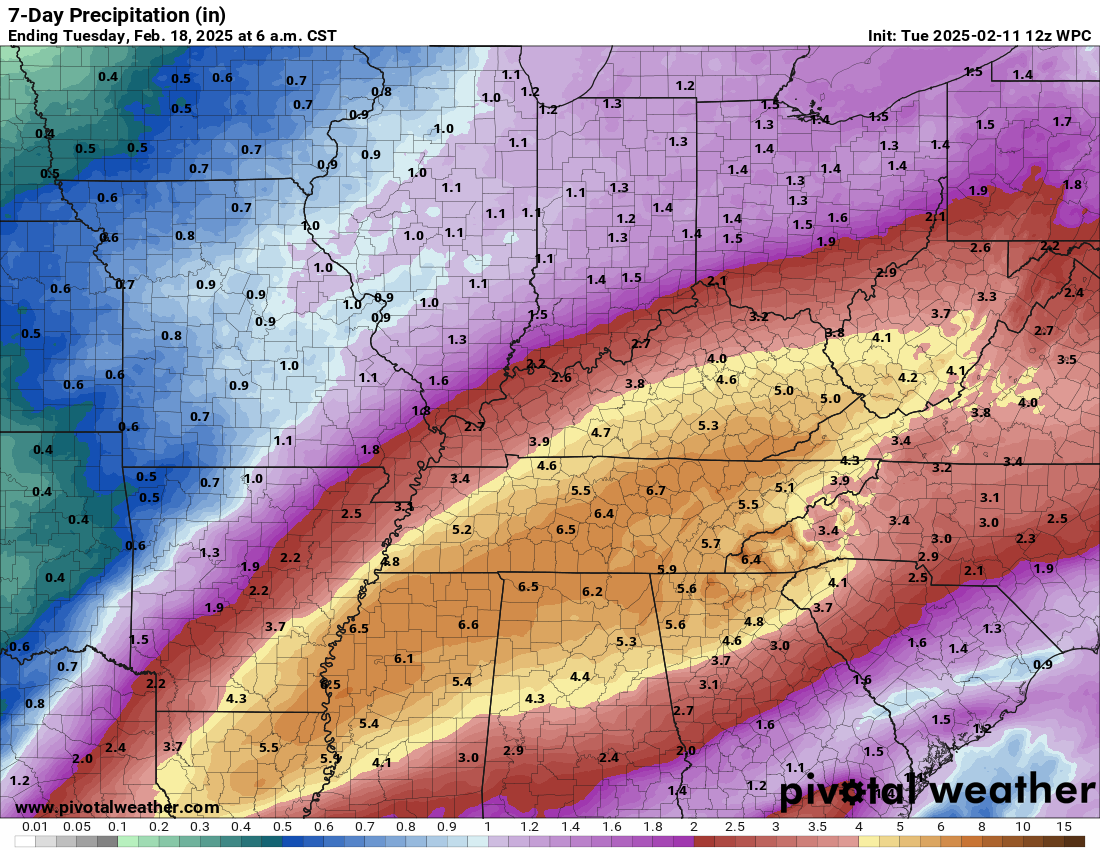
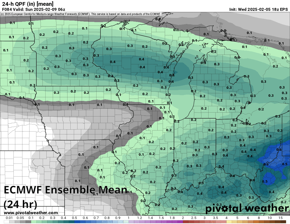
The first round of storminess arrives today with a second round tomorrow. A third round is penciled in for Saturday. Each round will bring widespread rainfall with embedded thunderstorms that produce even heavier rainfall. The forecast rain over the next 7 days is pretty impressive. NOAA’s Weather Prediction Center shows roughly 4 to 7 inches in a very broad area between southern West Virginia and northern Louisiana, with a bullseye from northern Mississippi into Tennessee.
Rainfall over the next week between 3 systems will total upwards of 4 to 7 inches, with embedded higher amounts likely between southern West Virginia and northern Louisiana. (Pivotal Weather)
Because of the antecedent conditions (or what ground conditions are like currently), a lot of this rain will be welcomed and absorbed into drier ground, with the exception of portions of West Virginia. That said, there will still likely be areas of flooding, and there are currently flood watches posted for some areas.
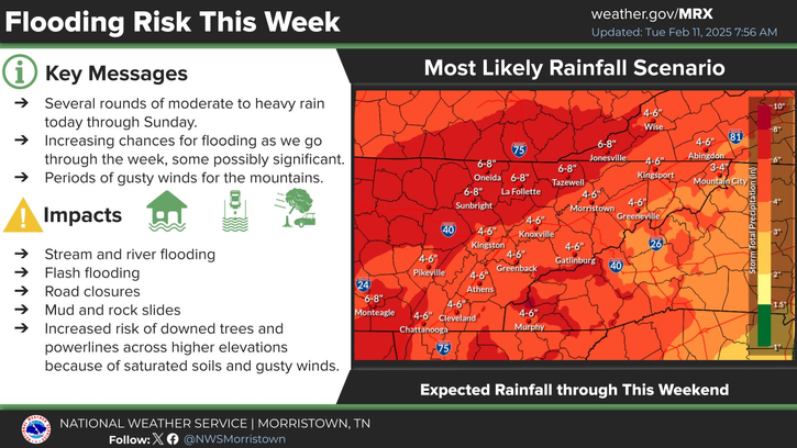
An increased risk of flooding is likely in eastern Tennessee, which will be likely to see some flooding and still has some vulnerabilities in the wake of last season’s Hurricane Helene. (NWS Morristown, TN)
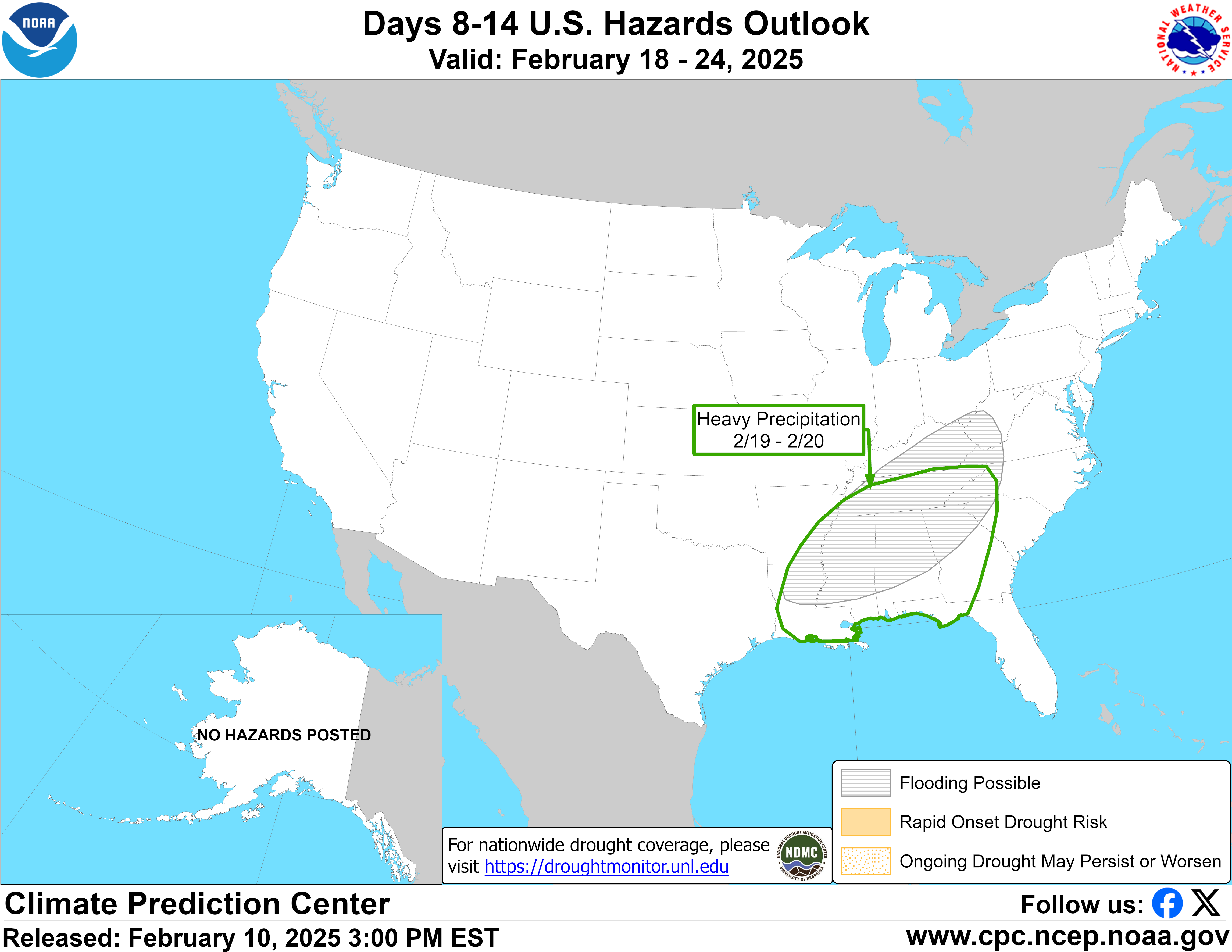
There can indeed be too much of a good thing, and it’s another round next Wednesday or Thursday that will probably be another one to watch. Models actually disagree on storm track and potential for wintry precipitation so there’s a lot here to unpack still. That said, it was enough to get a notation on the day 8 to 14 hazards outlook yesterday, with flooding possible.
Another round of heavy precipitation is possible next week, along with wintry weather to the north, though it’s far too early to say how much and what. (NOAA CPC)
I think the main takeaway here is that, while a lot of focus will be on the wintry weather to the north of these storms, the highest impact weather will likely be from multiple inches of rain that fall in the next 7 to 10 days or so across parts of the Southeast and the potential for flooding.
Southern California
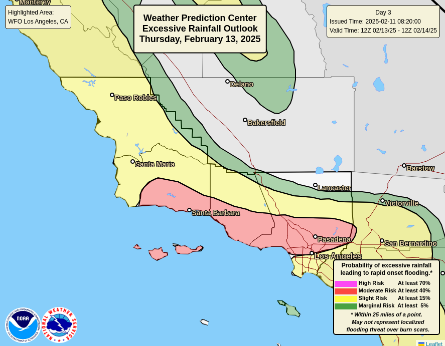
A significant rainstorm is going to impact Southern California beginning later tomorrow and especially on Thursday. There is already a moderate risk (level 3/4) for excessive rain and flooding, but especially mudslide and debris flow concerns over recent burn scars. The trouble is less the total amount of rain but how quickly it falls. Especially on Thursday, there will be the potential for torrential rains in parts of the LA Basin, perhaps accumulating at the rate of an inch an hour or even a bit more in spots. If you live on the Gulf Coast, that may sound like weak sauce, but the reality is that type of rain over fresh burn scars and in a city with terrain can cause some pretty bad flooding issues.
Torrential rain is possible in SoCal on Thursday, leading to a moderate risk (3/4) for flooding and debris flows. (NOAA WPC)
Total rainfall should be on the order of 1 to 3 inches with higher amounts likely in spots, especially in the foothills and mountains. Debris flows are a long-term concern after fires like the ones experienced around Los Angeles this year, so unfortunately the next couple years in particular will be challenging in those areas trying to recover.
One look at the day 3 through 7 hazards map issued by the Weather Prediction Center may cause some consternation, as it’s busier than a 4 year old’s crayon box.
There’s a lot going on here. (NOAA WPC)
We’ve got some heavy rain and mountain snow back in California, wind in the Rockies, cold in the North, heavy rain in the Ohio and Mississippi Valleys, ice potential in Appalachia and parts of the Great Lakes, and then heavy snow risk in the Northeast and Midwest. And Alaska too.
I want to focus on the storm potential this weekend from the Midwest through Northeast. In a nutshell, an upper-level disturbance is going to swing through the Upper Midwest and into the Northeast, with plausible interactions with other disturbances along the way that will likely produce a widespread snow for many areas, as well as the potential for a wintry mix to the south, across Ohio and Pennsylvania.
As highlighted above, there is potential for heavy snow on Saturday from South Dakota into the Twin Cities in Minnesota across Wisconsin into the northern half of Lower Michigan. Is this a slam dunk? Not yet. If we look at precipitation forecasts from the various models, there are some disparities in where the highest precip totals are drawn. So for anyone in this region, there is some fail mode to this forecast.
Total precipitation forecast this weekend from various weather models. (Pivotal Weather)
Modeling, with the notable exception of the ICON model (and GFS to a lesser extent) seems to agree on a general precipitation maximum between the Twin Cities and along I-94 in Wisconsin. It extends across Lake Michigan into Lower Michigan, primarily north of Grand Rapids. Within this band of precipitation, models suggest anywhere from about 0.30″ to 0.60″ of liquid equivalent. That would constitute at least 5 to 9 inches of snow, using about a 15 to 1 ratio of snow to liquid. Expect a somewhat narrow but significant band of accumulation somewhere probably from northern South Dakota into Minneapolis-St. Paul into central Wisconsin. Another bullseye is likely across Lower Michigan, again north of Grand Rapids and probably east to the Thumb, including Sagniaw.
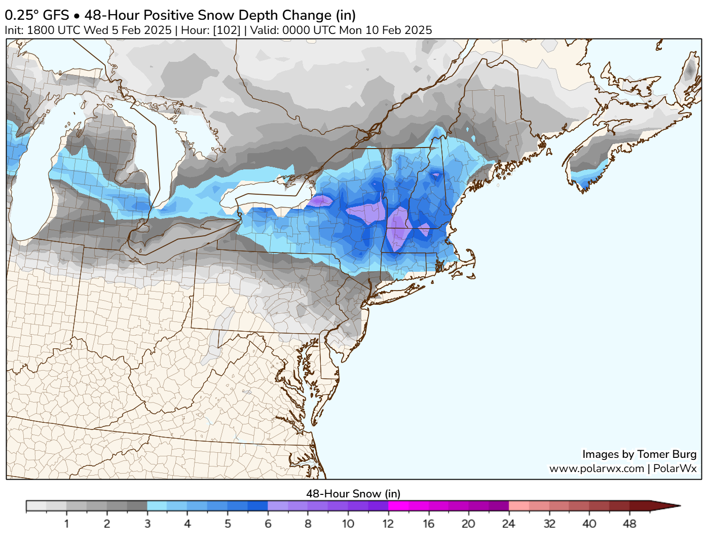
Once the storm clears the Midwest, its next phase will be in the Northeast. Don’t focus on the specifics below but rather the location of the maximum positive snow depth change according to the GFS model.
Snow accumulation may be highest in the mountains of Upstate New York, southern Vermont, Massachusetts, and New Hampshire. (PolarWx.com)
The bullseye, at least according to this model would occur in the southern Adirondacks, southern Greens, Berkshires, and portions of New Hampshire. At this point, it’s too early to overspeculate on amounts but suffice to say a “plowable” snow is a plausible outcome there, after the current week’s lighter snow and light ice.
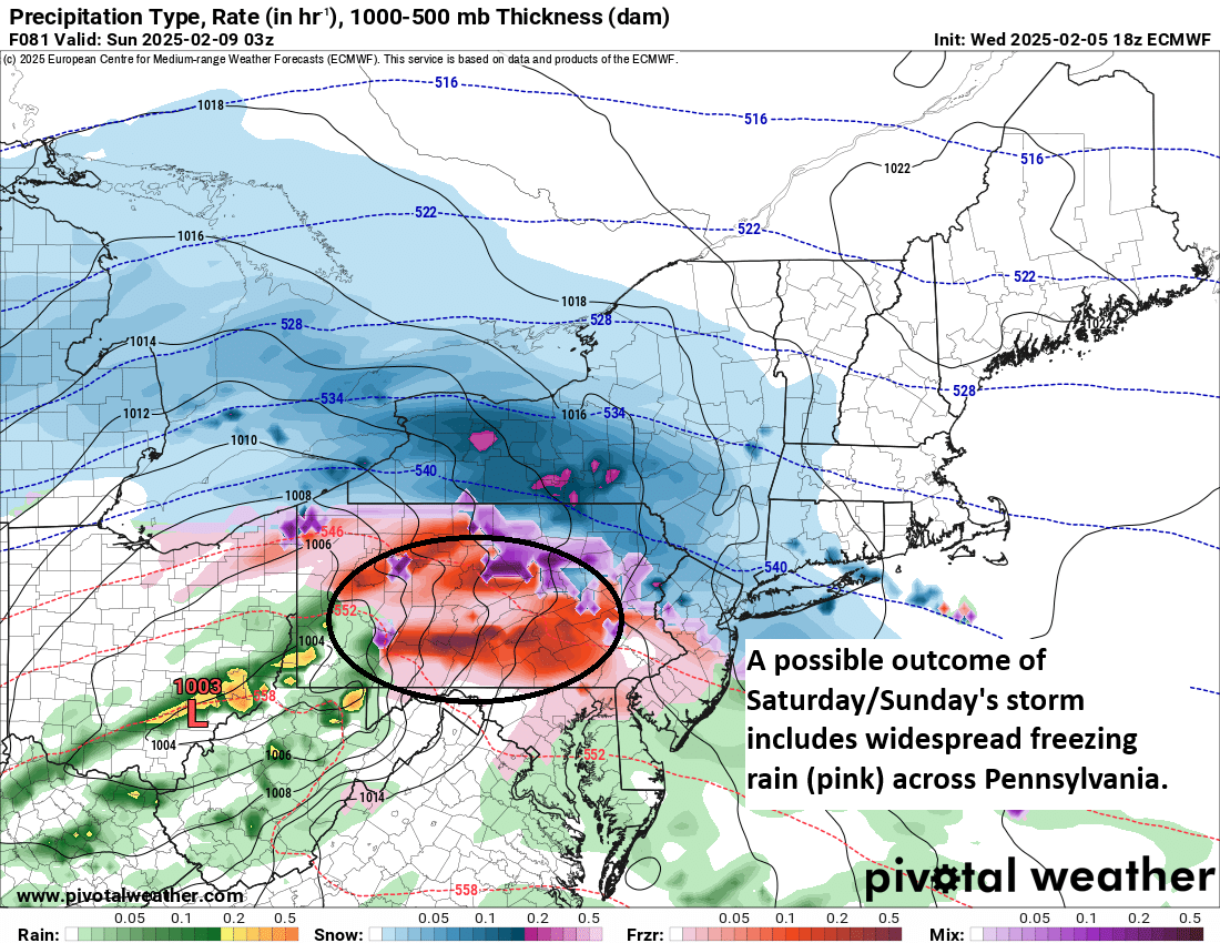
Speaking of ice, this next storm will also come with some of that too. Sunday’s forecast from the European model does indeed show widespread freezing rain across much of Pennsylvania. While it’s too soon to get extra specific in terms of ice accumulation, another round of 0.10 to 0.25 inches of ice accumulation is possible this weekend.
Potential for another quick hitting round of freezing rain is in the cards for Pennsylvania. While ice accumulation doesn’t look severe, a tenth to quarter-inch of ice build up would cause travel problems across the region. Again. (Pivotal Weather)
The real takeaway from all this is if you have travel plans anywhere along the I-90, I-80, or I-94 corridors this weekend, you would be wise to plan ahead and be prepared for hazardous winter weather.
Another storm is possible next week, with perhaps more to follow. As we noted earlier this week, it looks like an active period is setting up across parts of the country.
A final word
Today is National Weatherpersons Day! I would be remiss if I didn’t give a special thank you to our friends and colleagues that work across the industry to serve their communities and keep people safe and informed. From broadcasters to private sector meteorologists to researchers to government meteorologists, we all work together to achieve a similar end goal: Minimize risk to lives and property.
In particular, I want to note our friends at the National Weather Service across the country. There is a lot going on right now, and whether you agree or disagree with it, you know what those NWS employees are still doing right now? Creating forecasts and issuing warnings and alerts to keep their communities safe. Whatever distractions they have to manage right now, they still show up to serve us all. I have come to know many NWSers, and they put up with a lot on a good day, including a grueling schedule that requires virtually all of them to work overnights every few weeks. They sacrifice time from their families and their lives to serve the communities in which they live. And they are some of the most servant-minded individuals I have ever come to know. They care, they work hard, and they provide a public service that is virtually unmatched in terms of return on taxpayer investment, saving our country and economy billions annually and saving countless lives in the process. To them, we are grateful and simply put cannot expect to do our jobs effectively without the work they do. Thank you to all meteorologists, but especially those at the NWS, especially now. I hope everyone else realizes this when they hear various news nuggets about NOAA and NWS in the days and weeks ahead.
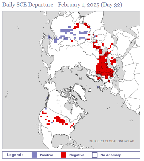
Those are the approximate snowfall departures from normal this season as of Sunday for Minneapolis, Chicago, New York City, and Concord, NH. Much of the country is in a bit of a snow deficit right now, as evidenced by the snow cover departure map below from the Rutgers Global Snow Lab.
Snowfall anomalies are negative (below average snow) across much of the country right now. (Rutgers Global Snow Lab)
It’s been so bad that as of February 2nd, Chicago and Minneapolis both have only about an inch more of snow on the season than does Pensacola, FL. While this speaks more to the lack of snow up north than the surprise snow down south, it’s still a bit of a shock.
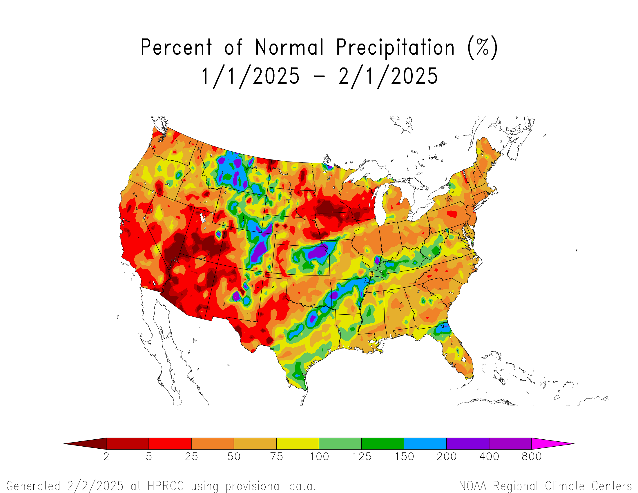
If you look at how January finished in terms of precipitation (not just snow, but all forms of precip), most of the country ended up drier than normal, taking the whole “Dry January” thing a little too far.
Total precipitation has been below normal except in the Rockies and parts of the Plains and Ohio Valley for the most part so far in 2025. (High Plains Regional Climate Center)
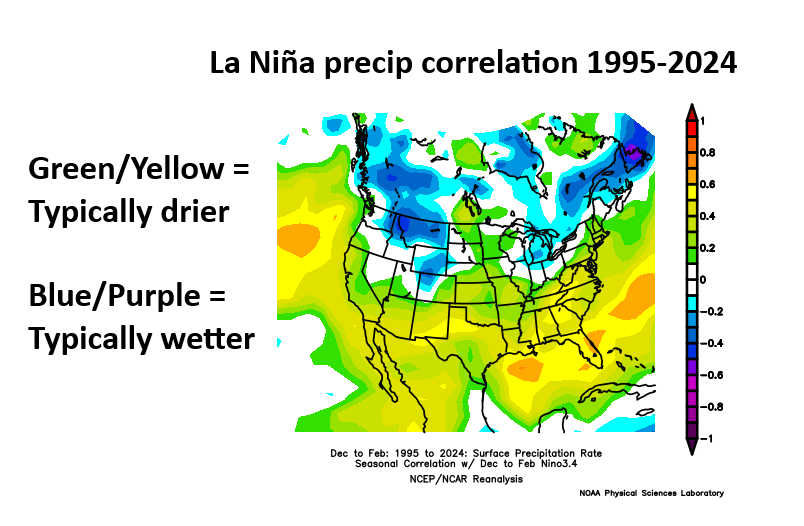
Last week we discussed La Niña and how it finally became established in December. It’s not uncommon for La Niña to generally produce drier than normal weather across the United States. So in theory, this makes sense.
A typical La Niña since 1995 would be drier than normal across much of the country, with the exception of the Great Lakes and Rockies. (NOAA PSL)
The conventional wisdom is typically that SoCal through Texas and Florida are usually dry in La Niña, but over the previous 30 years, the signal for dry does extend to cover much of the country. It surely does not guarantee dry weather, but it tends to skew the odds in that direction.
So, here we are, after a drier than normal January and with snow departures racking up all over. At some point it changes, right? It can. Usually as we transition toward spring, the stronger dry signals we see above start to break down more to “coin toss” territory. But what about in the shorter-term? Well, that brings us to the models.
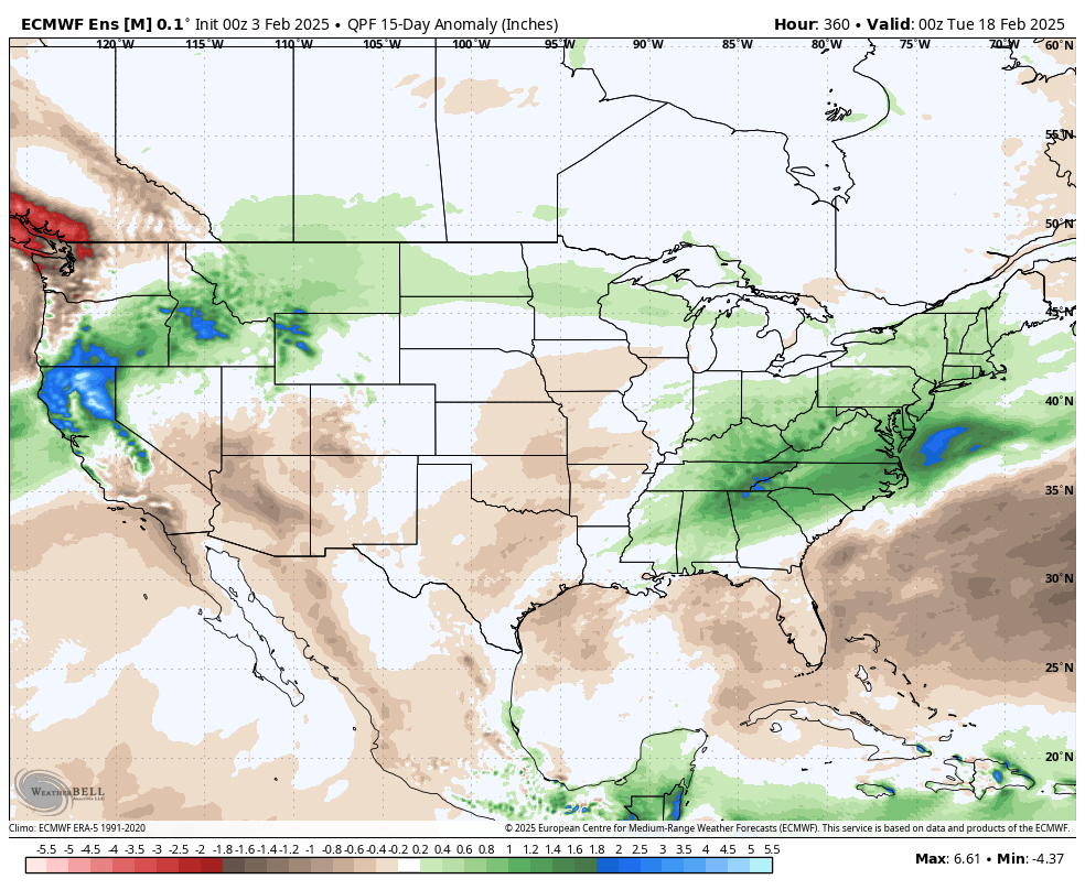
Forecast precipitation anomalies over the next 2 weeks, show a wetter than average eastern U.S., northern Rockies, and northern California. (Weather Bell)
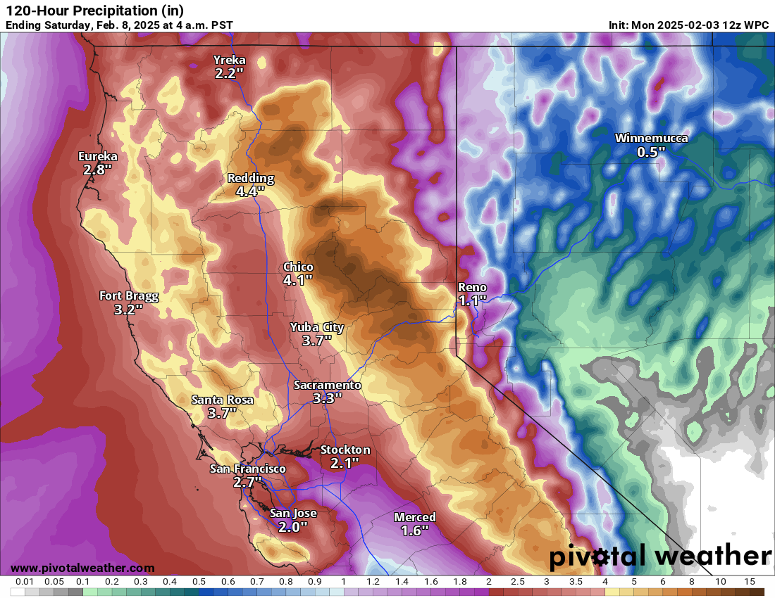
Over the next couple weeks, there are signs at least that a series of storms may cross the middle of the country. In my experience, when you have the type of clobbering we’re seeing in California right now, that usually produces something downstream. Over the next 5 days, northern California will indeed continue to cash in from an ongoing atmospheric river event with anywhere from 6 to 10 inches of liquid equivalent precipitation in the mountains. This should boost snowpack, which is running at a deficit this season.
Precipitation over the next 5 days in California will help the Sierra snowpack situation. (Pivotal Weather)
But notice on that Euro map a couple images up. There is definitely a signal of some sort change in the precipitation pattern we have seen thus far in 2025. Yes, the northern Rockies still look to cash in, but so will the Northeast, Mid-Atlantic, and Tennessee and Ohio Valleys. As well as the area near and north of the Great Basin. The question for folks east of the Rockies would be: Will it snow? And the answer appears to be “maybe?”
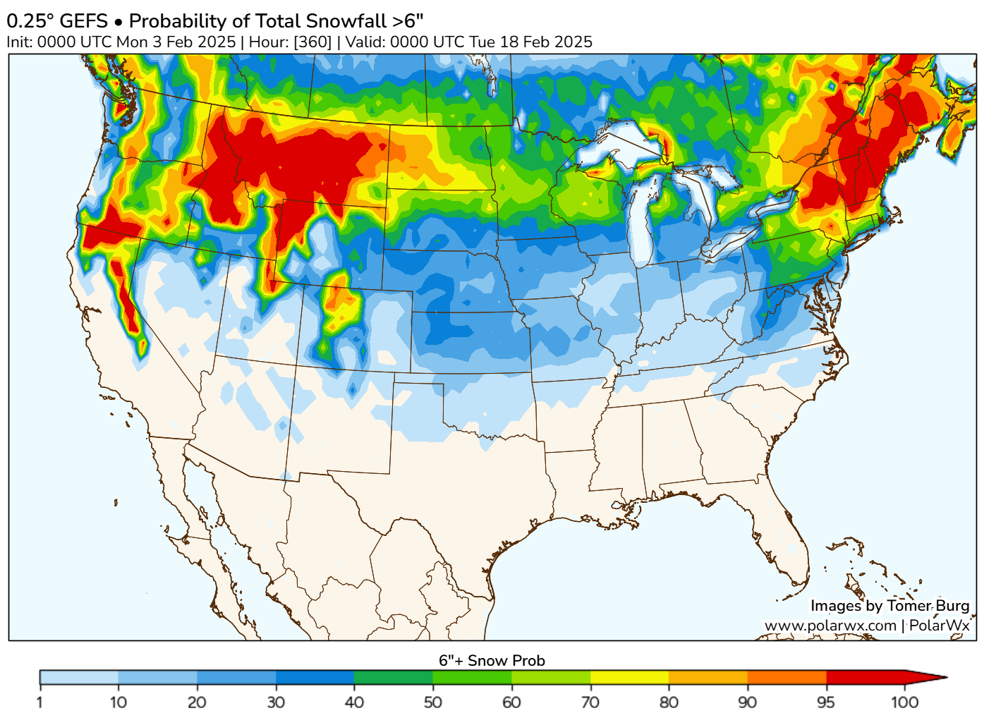
GFS Ensemble probability of 6 inches or more of snow over the next 2 weeks. (PolarWx.com)
The map above shows the probability of 6 or more inches of snow over the next 15 days. And indeed some areas that have been experiencing a bit of a “snow drought” so far this winter may see some ability to cash in now. How this unfolds? It will come in waves. We’ll likely see a somewhat significant storm later this week, followed perhaps by another one this weekend and yet another storm or two next week, along with perhaps some colder air in the mix. While the details are far from clear at this point, the take home message is that we may be seeing a bit of a change in the pattern to help snow lovers out in spots. Not everywhere but that may be the best we can hope for in a winter like this.
After a respite, cold weather may try to re-emerge in mid-February in the eastern two-thirds of the United States.
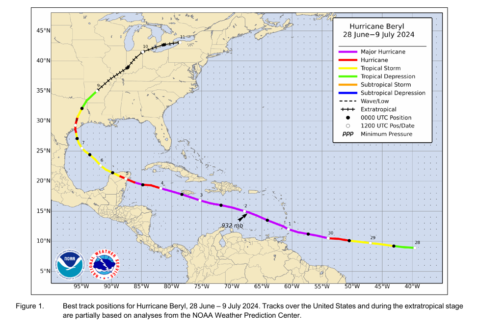
Hurricane Beryl’s post-season report was issued last week, and we got a few new nuggets of data to digest.
La Niña became official in December, but what happens as we head toward summer may be in coin toss territory right now.
Winter may give it another go for the Midwest & East
Things are generally quiet in the weather space, or at least there are no real extreme impact events to discuss right now. That’s good at least. So let’s discuss the winter situation.
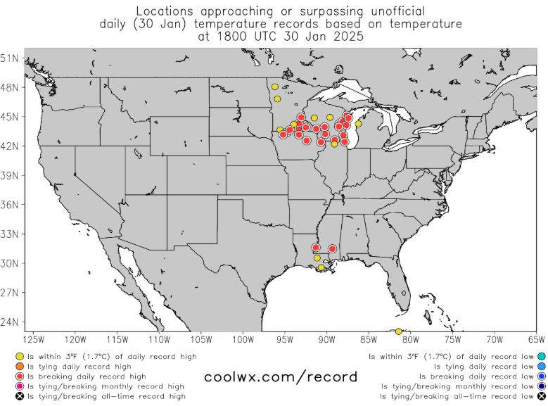
Numerous locations in the Upper Midwest saw temperatures break records today.
Record highs being set in red all over the Upper Midwest on Thursday. (Coolwx.com)
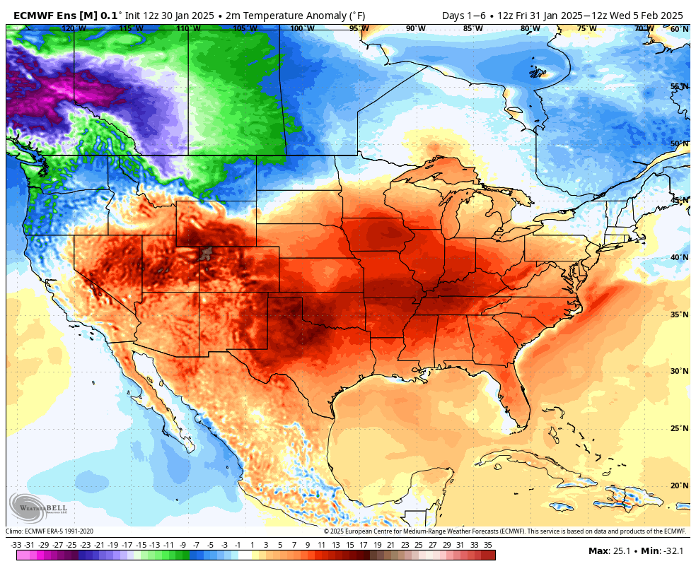
Since last week’s cold, much of the country has shifted back to warmer than normal weather this week. The exception to this is in the interior West. Over the next 5 or so days, this warm pattern is expected to continue.
Average temperature anomalies from Friday through Wednesday morning. (Weather Bell)
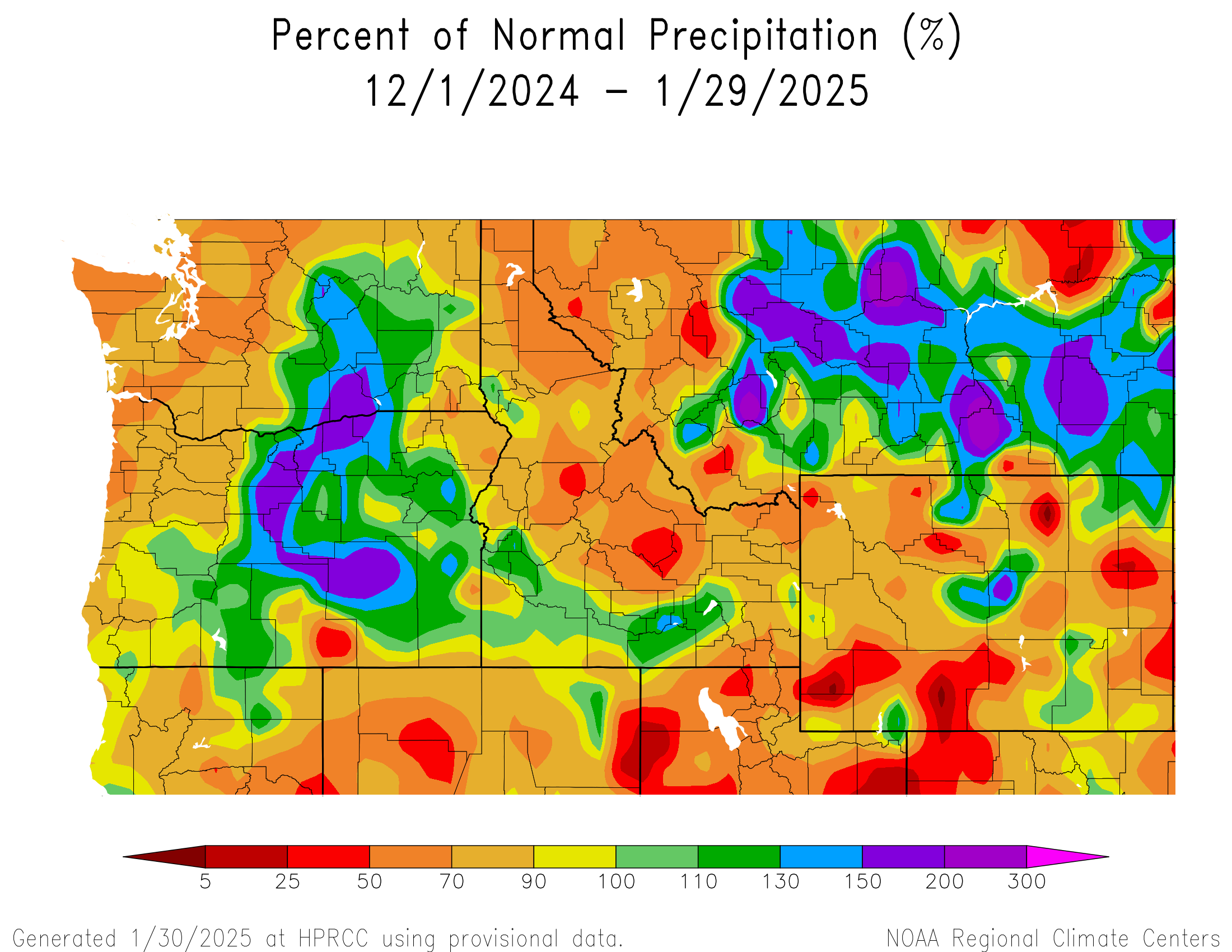
The Northwest will begin to see some stronger cold and also some solid mountain snow. This is an area that has had some very mixed results over the last couple months in the precip department. Portions of Oregon have done great, while much of Idaho, the Cascades and portions of the interior West have done not so great.
The last two months of precipitation as a percent of normal have shown Oregon doing well, in addition to Montana. Other locations have been less fortunate. (High Plains Regional Climate Center)
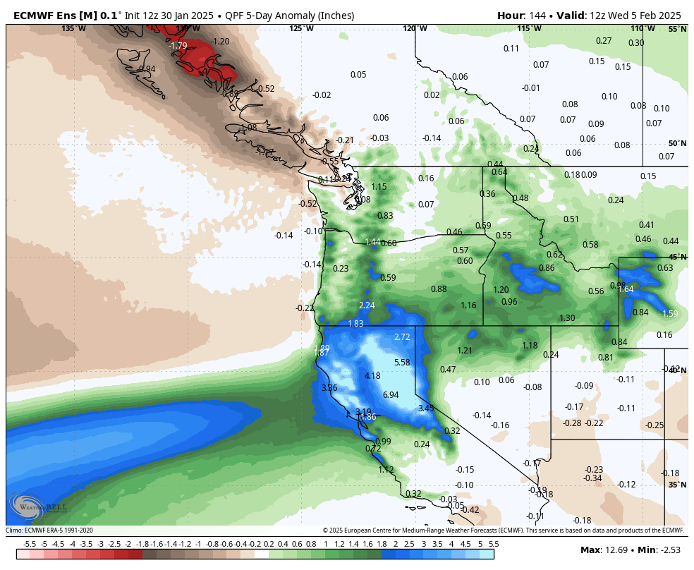
Portions of California are expected to really cash in, though unfortunately it will be mainly just the north, not Southern California. And places in the Northwest will be allowed to catch up over the next 5 days.
An atmospheric river will slam northern California with heavy rain and mountain snow, while the interior Northwest and portions of the Cascades play a bit of catch up in the precip department.
So, warmer nationally but a bit cooler and much wetter in the Northwest over the next 5 days. Then what?
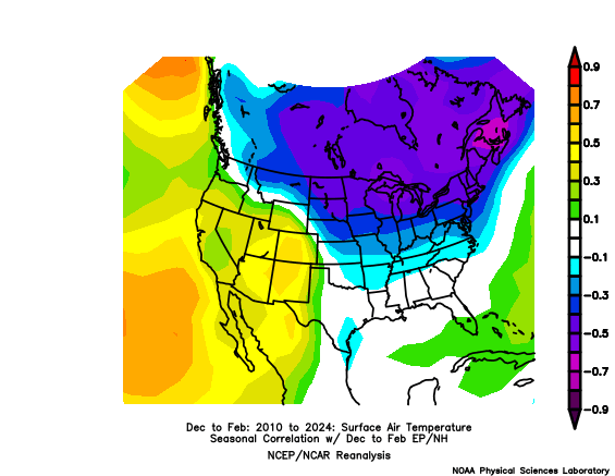
Well, changes are afoot again. When we look for cold risks in the U.S., we often look to Alaska. Frequently, what happens in the Continental United States (CONUS) is that when a large ridge of high pressure pokes up over Alaska, it tends to dislodge the cold and send it south and east. Exactly where that ridge establishes, its strength, its duration, etc. can all yield differences in outcome. But in general, for meaningful cold in the CONUS, you need that to happen in Alaska.
A general correlation between Alaska ridging and US air temperatures over the last 15 winters shows that ridges over Alaska typically yield colder risks in the Eastern U.S. (NOAA PSL)
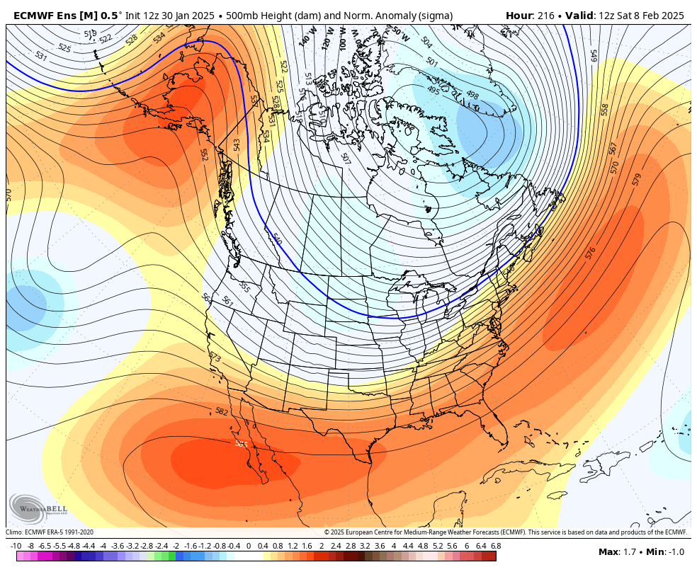
Well, the models are perking up a good bit about the potential for some meaningful ridging in the upper atmosphere over Alaska. In other words, they’re showing the pattern that would typically be favored to produce a colder Eastern U.S. In fact, today’s European ensemble model run shows basically a 2-sigma ridge over Alaska by next weekend. In plain language: That’s a potentially strong ridge.
A strong ridge may build up over Alaska next weekend, allowing for cold air to try and migrate eastward into the Midwest or Great Lakes. (Weather Bell)
Impressively, this shows up in the ensemble mean, which is an average of 51 different ensemble members. The signal is a bit weaker on the GFS model and in the AI modeling we look at, so nothing is guaranteed at this point. But with that said, there’s a signal here, and it’s one that says cold may reload for portions of the country where it’s currently absent. Something to watch in the days ahead.
Beryl was confirmed as the earliest category 5 storm on record in the Atlantic Basin. In the report, the NHC explains that while Beryl will officially go in the books as a 165 mph category 5 hurricane, there is a bit of ambiguity in that the peak intensity may have been slightly overestimated by the various methods utilized to estimate the intensity. It’s likely that if that peak intensity is incorrect, it is not off by much. Beryl made landfall with roughly 135 to 140 mph sustained winds on Carriacou Island in Grenada. No reliable observations of wind speed exist in that area.
Notably, Beryl’s landfall intensity was reduced significantly on the Yucatan. In real-time, it was assumed to have 110 mph winds. In the reanalysis, it is estimated to have maximum sustained winds of 90 to 95 mph. And then as we note in our Space City Weather post linked above, the landfall intensity was increased to 90 to 95 mph in Texas, up from 80 mph estimated in real-time.
A number of milestones prior to August were achieved due to Beryl including strongest storm (165 mph) so early in the season on record in the Atlantic, besting 2005’s Hurricane Emily in July (160 mph). I think one of the most impressive records Beryl matched though was the fastest rate of intensification (65 mph in 24 hours) so early in the season on June 29-30, matching July 2008’s Hurricane Bertha. Additionally, Beryl is now the storm of record for Grenada.
Beryl was a challenging storm in many respects, between impacts and forecasts. We learned a lot that helped us a lot through the balance of hurricane season, but you can be sure that Beryl will be on the list of names to be retired this year, likely including Helene and Milton.
La Niña checkup: It’s here, but will it stay?
Last we discussed La Niña, it was likely in the context of how the rest of hurricane season would behave or why the season did not quite go as planned.
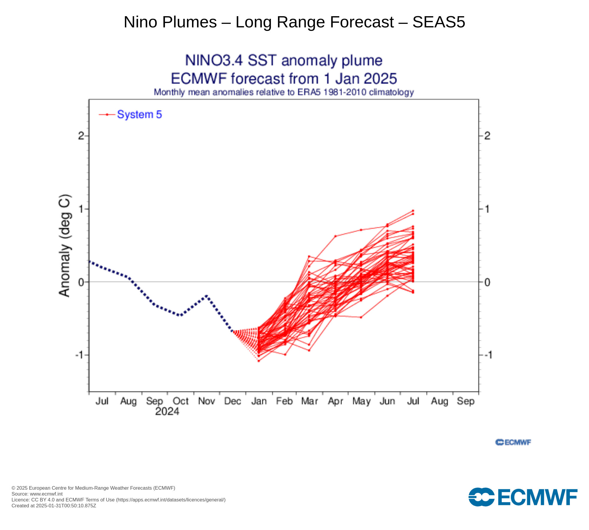
La Niña is here, and it’s likely to stick around a little longer. The summer forecast is much more uncertain, however. (ECMWF)
It took some time, but we officially had La Niña designated in December. So it’s here. That said, it’s not an especially strong one. This is one of the weaker first year La Niñas in recent years, I am guessing since at least 2016-17 or 2013-14. That’s not to say it won’t have impact. The dryness in SoCal and wetter conditions to the north are usual hallmarks of a La Niña, though it has been magnified to an extreme this year. Even weak La Niñas can aggravate other factors and cause major problems.
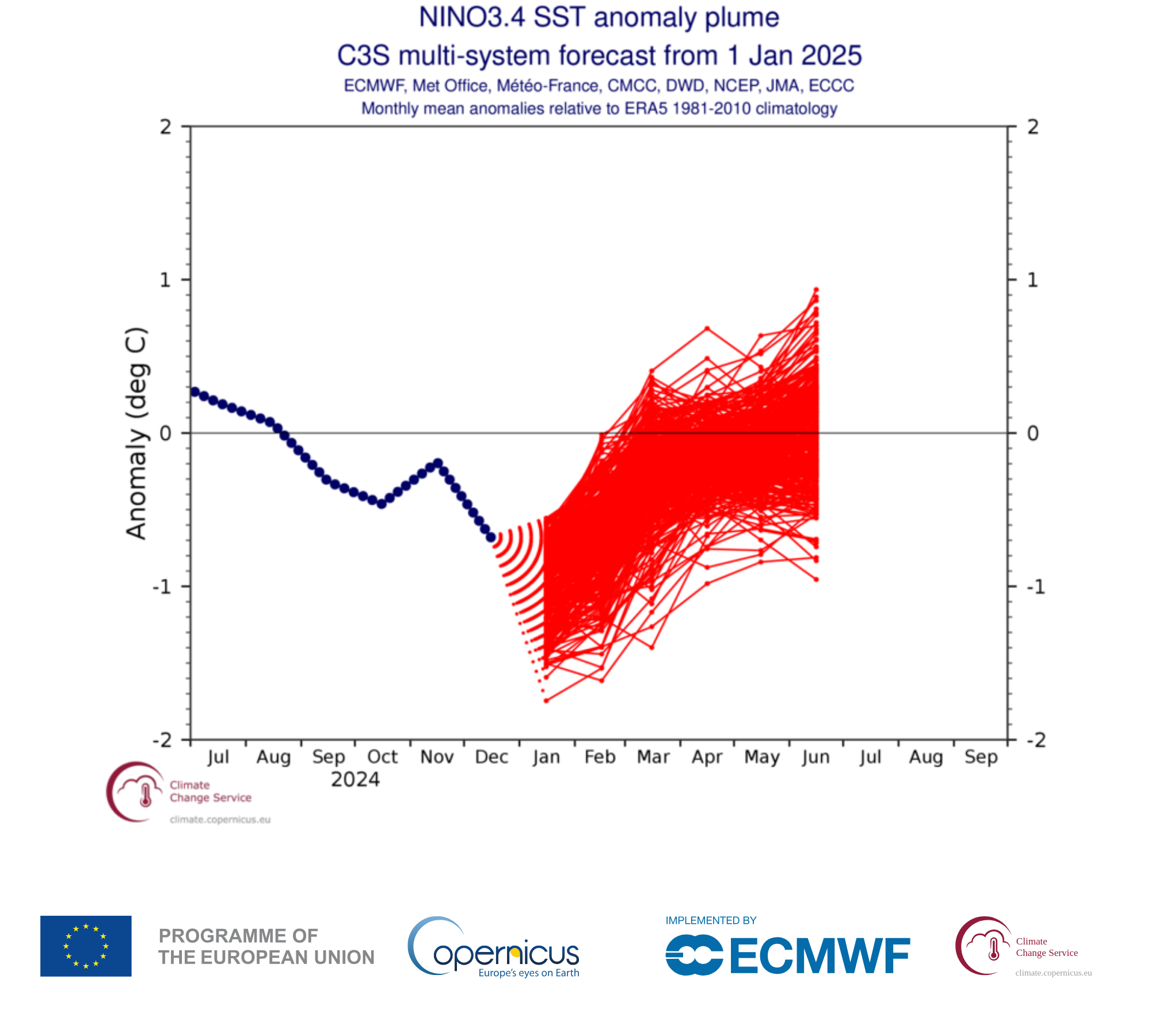
Per the ECMWF forecast above, we may shift into El Niño conditions in summertime. However, a look at the broader group of seasonal forecast models from eight different government agencies paints a much murkier picture.
A broader ensemble sampling says ¯\_(ツ)_/¯ (shrug) for summer. (Copernicus Climate Change Service)
We are entering what is known as the spring predictability barrier, where for some reasons that aren’t entirely clear, seasonal forecasting of El Niño or La Niña struggle. So, it’s wise to take everything with a grain of salt right now. We’ll continue tracking this as we head toward hurricane season, as it can have significant impacts on the season’s projected trajectory. Stay tuned.