Heavy rain, strong winds likely well into tomorrow there, as Ernesto slows down and crawls past.
Ernesto will brush Newfoundland on the way out to sea next week.
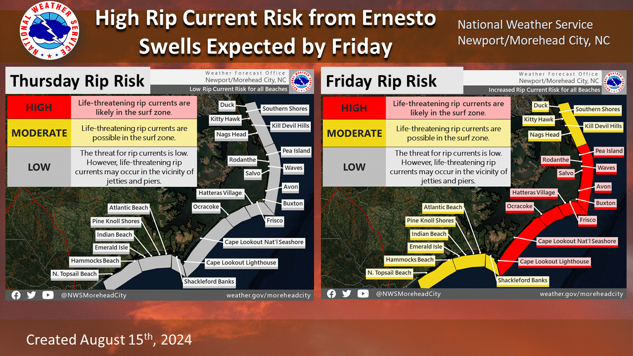
Dangerous rip currents likely up and down the East Coast this weekend with Ernesto’s large size and waves.
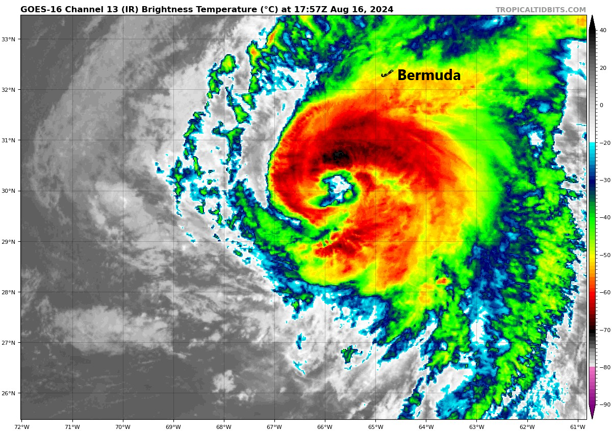
Ernesto on approach to Bermuda
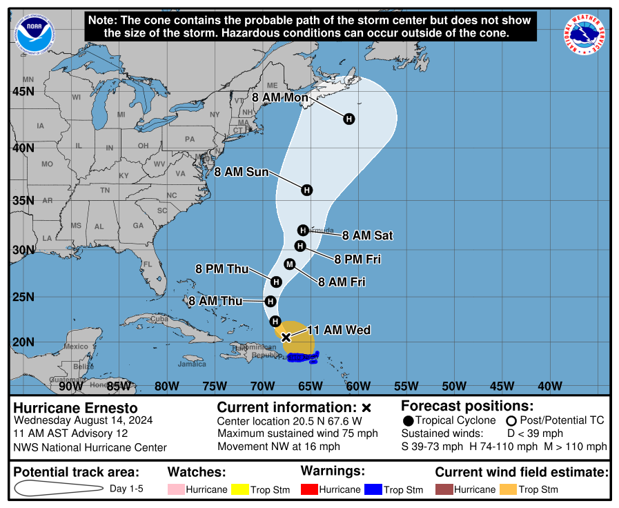
Hurricane Ernesto is now a category 2 storm, with maximum sustained winds of 100 mph — probably. Ernesto is not the healthiest hurricane we’ve ever seen, but it’s a large one.
Ernesto is clearly feeling the presence of some wind shear and maybe a little lingering dry air as it approaches Bermuda. (Tropical Tidbits)
Ernesto is loaded with moisture, and the wind field is enormous. Tropical storm force winds extend out 275 miles from the center. What Ernesto may lack in intensification it more than makes up for in size. Conditions are beginning to go downhill on Bermuda this afternoon, and that will continue into tonight, as evidenced by a lot of rain (and embedded wind) showing up just south of the island.
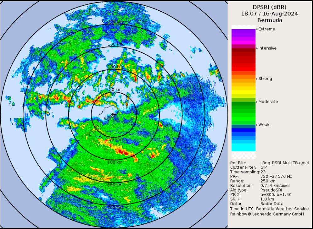
Radar snapshot of Ernesto’s rains closing in on Bermuda this afternoon. (Bermuda Weather Service)
So even if Ernesto weakens over the next day or so, it will pack plenty of punch on Bermuda, particularly due to the duration of the storm. Ernesto will slow down a good bit through Sunday before picking back up forward speed and accelerating out to sea and weakening once more.
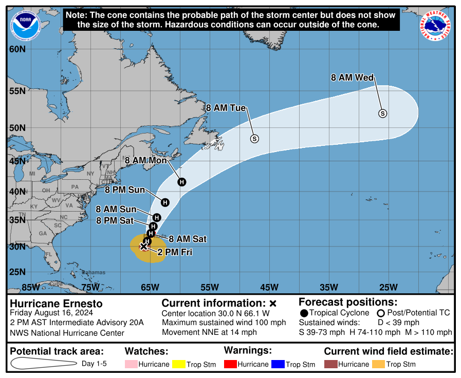
Ernesto will move sluggishly through Sunday before picking up a lot of forward speed Monday and Tuesday and accelerating out to sea. A close brush with Newfoundland cannot be ruled out. (NOAA NHC)
As Ernesto passes Newfoundland, likely just to the south, some impacts are possible there as well, though they would probably hit and exit quickly. Tropical storm force winds and locally heavy rainfall are the main concerns.
In addition to Ernesto as a hurricane, we continue to advertise the extremely rough surf and rip current risk up and down the East Coast that’s expected this weekend. With a wind field of 275 miles, you can bet that Ernesto will be churning out some waves. Dangerous rip current risk will be moderate to high along virtually the entire East Coast by tomorrow and Sunday.
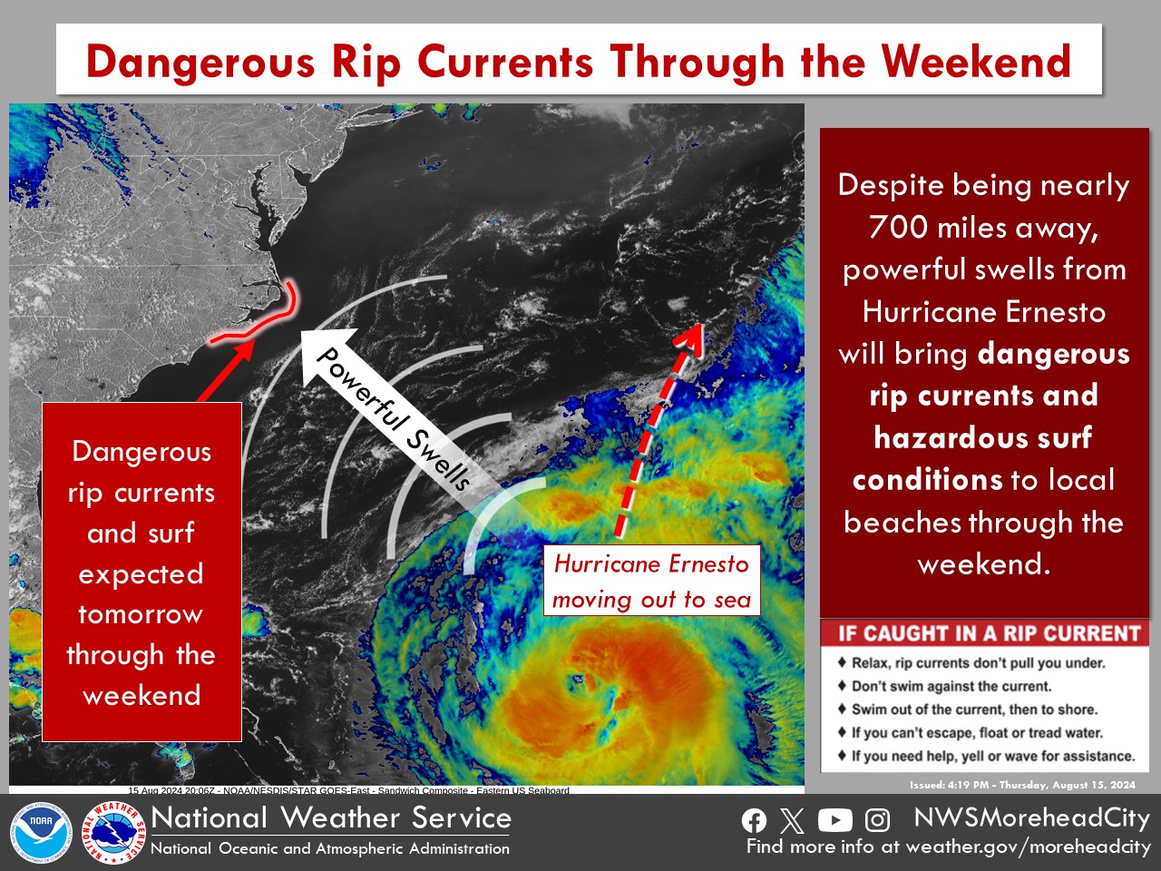
A significant rip current event is likely this weekend on the East Coast due to Ernesto’s large size and waves. (NWS Morehead City)
We again urge folks to use caution in the water this weekend.
Behind Ernesto, we continue to advertise calm for next week. We’ll talk more about that next week and assess when it could change.
Hurricane Ernesto prompts Hurricane Warnings for Bermuda as it tracks in that direction.
Look for somewhat prolonged wind, surf, and rainfall impacts in Bermuda beginning tonight into Friday.
Ernesto is large in size and will generate rough surf and dangerous rip currents far from the center along the U.S. East Coast heading into the weekend.
Impacts are possible in Atlantic Canada Sunday or Monday, particularly in Newfoundland as Ernesto comes north and accelerates out to sea.
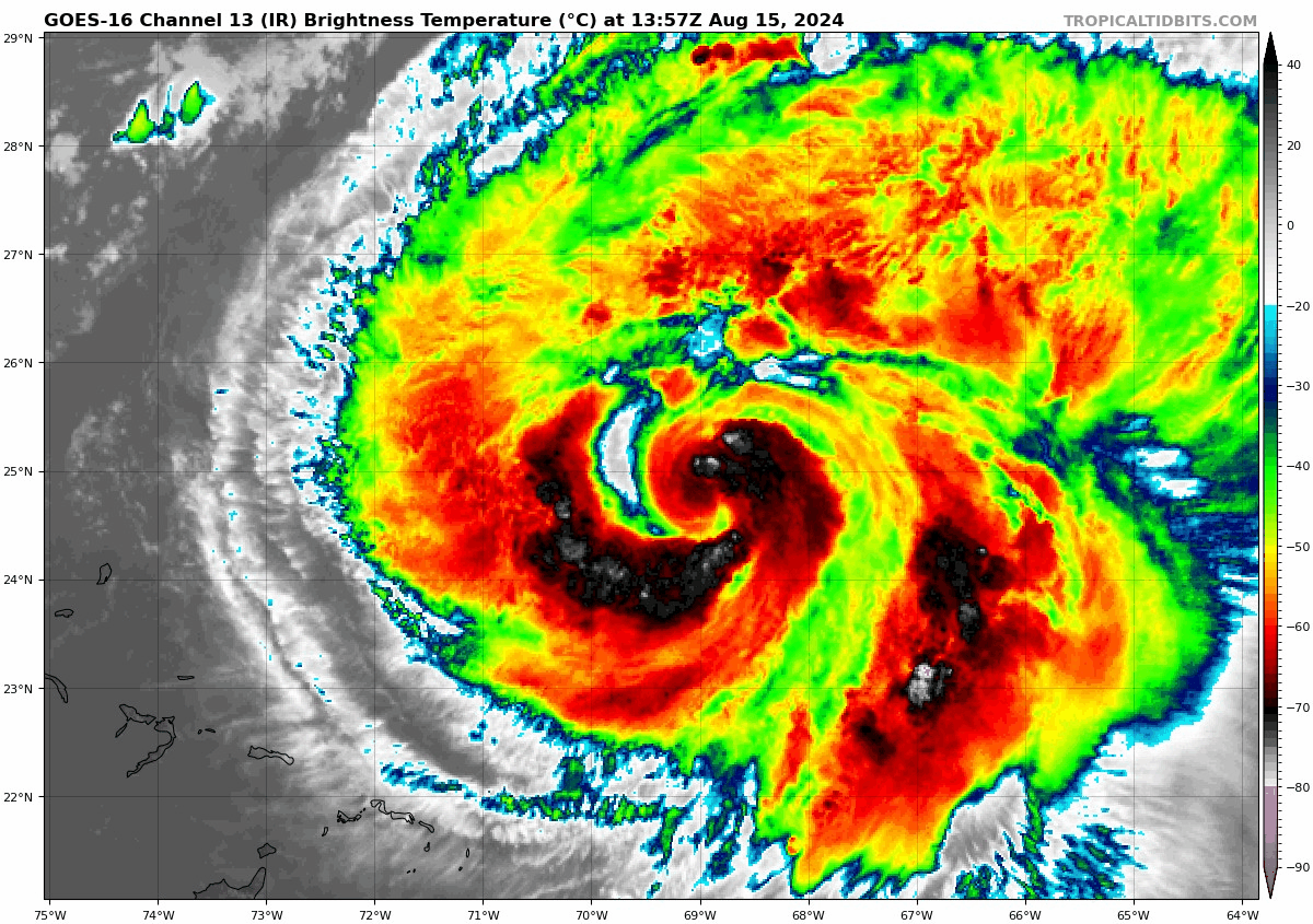
Ernesto struggling a little this morning
Hurricane Ernesto is moving along, north around 14 mph this morning over the Atlantic. A look at Ernesto on satellite tells the story pretty well.
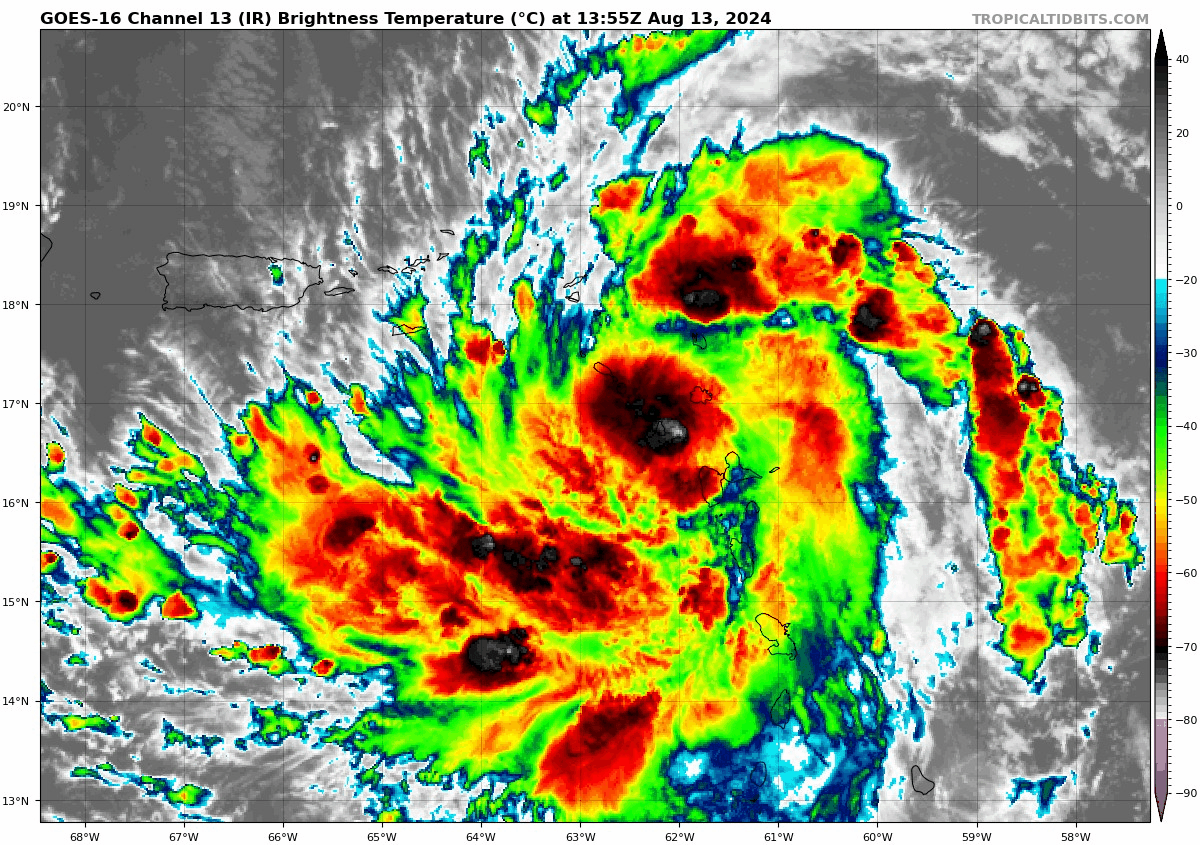
Ernesto is dealing with dry air as indicated by some of the gaps in colder cloud tops (red/orange) in the inner core of the storm. (Tropical Tidbits)
It’s pretty clearly fending off some dry air. It’s also a bit of a larger storm in size, with tropical storm force winds already extending out 175 miles from the center. The combination of Ernesto’s size and some of that dry air wrapping in is keeping a lid on much intensity gain today. The current maximum sustained winds are around 85 mph.
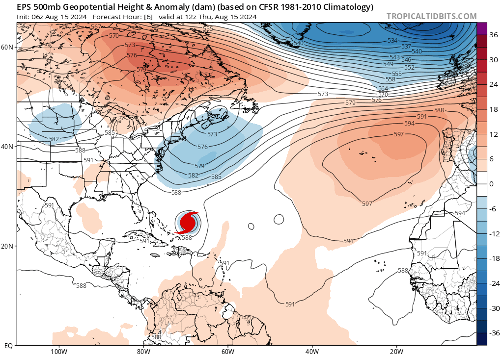
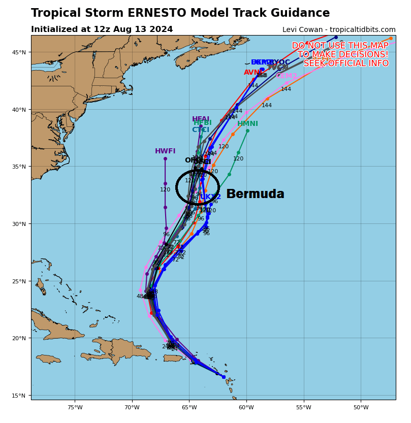
Ernesto’s track forecast
Ernesto is about 570 miles south southwest of Bermuda. Ernesto is going to take a weird track of sorts over the next 3 days or so, off to the north northeast, then northeast, then perhaps bending back north a bit. This is all due to steering currents that will be pushing Ernesto around. As I noted yesterday, the first trough will try to grab Ernesto and force it off to the northeast toward Bermuda. But as Ernesto approaches Bermuda, it will slow down and begin to turn back north somewhat as that trough exits. This will lead to a very close approach with a direct hit on the island. Regardless, hurricane conditions are likely to impact Bermuda by late tomorrow or Saturday, and a Hurricane Warning is in effect there.
The upper level map and approximate location of Ernesto every 12 hours through Monday evening as forecast by the 51 member European ensemble mean. (Tropical Tidbits)
Beyond Bermuda, Ernesto will likely resume a slow northward movement in between two troughs. The next one moving in from the Great Lakes will try to also “grab” Ernesto, but it will also be following the steering currents around high pressure between Bermuda and the Azores. Thus, we should see Ernesto resume a slightly faster north northeast or northeast motion. Whether this happens fast enough to avoid a collision with Newfoundland remains to be seen. This will probably pass east of Nova Scotia and Prince Edward Island, however. Still, it’s likely that Atlantic Canada will see at least some impacts from Ernesto as it passes by, including gusty winds, rough seas, and perhaps some heavy rain.
Ernesto’s intensity and impacts
In terms of intensity, Ernesto should continue to slowly strengthen over the next day or two as it approaches Bermuda. Depending on how much it can whittle away the dry air, it may approach major hurricane intensity before passing close to or over Bermuda. It’s also worth noting that the slowing forward motion as it approaches Bermuda will likely prolong some of the wind, rain, and surge issues on the island. So even if this comes in a bit weaker than forecast, it may punch above its weight class given the slow movement and prolonged impacts. Bermuda is no stranger to hurricanes, but folks should take this one seriously.
Strong rip currents and rough surf will be likely this weekend on the East Coast of the U.S., likely leading to dangerous swimming conditions at times. (NWS Newport/Morehead City)
In addition, on the East Coast of the U.S. rip currents are going to become an issue heading into the weekend as Ernesto passes offshore, especially given the large wind field of Ernesto. Please follow all posted signs and flags at the beach this weekend. Rip currents are deadly, with nearly 30 deaths so far this year from them.
Ernesto should be out of the picture after next Monday or so, followed up by a period of calm Atlantic tropics. There may be some signs of life very late on model runs in the far eastern Atlantic, but we’ll see.
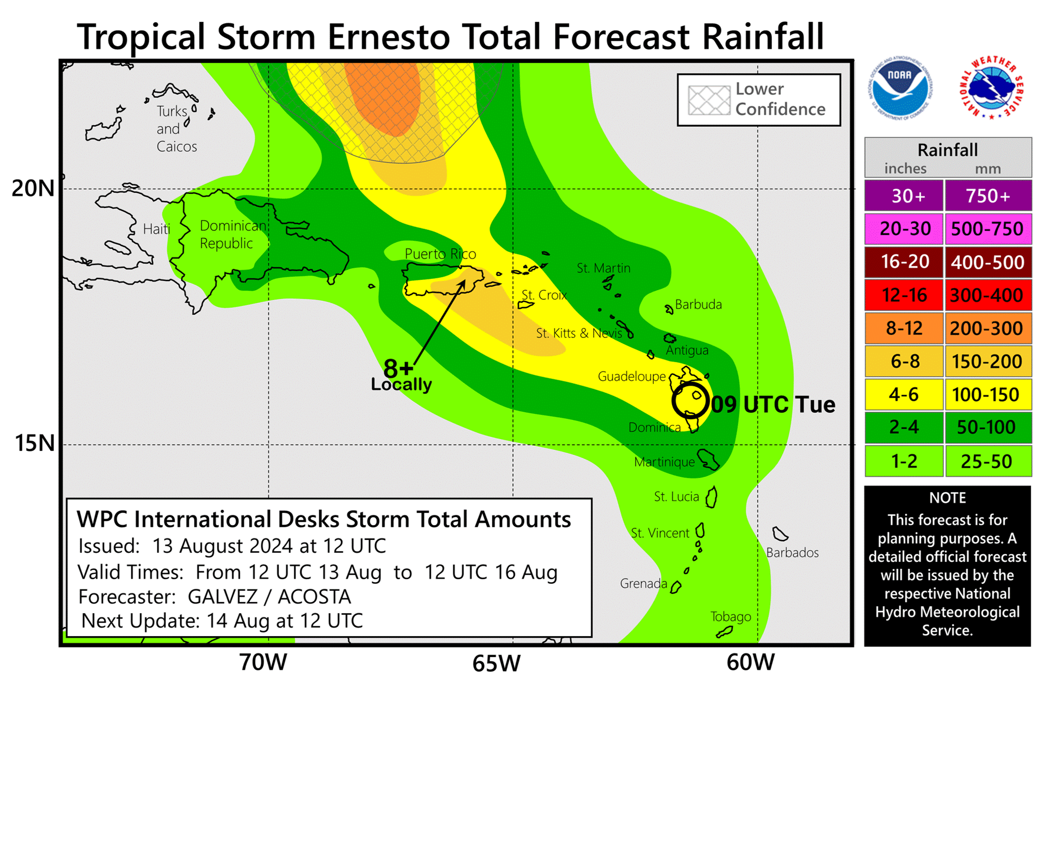
Hurricane Ernesto delivering torrential rain and flooding to Puerto Rico.
Ernesto will continue to pull away north of the Caribbean, relaxing impacts there.
The hurricane will track toward Bermuda for late week and this weekend, coming very close and likely delivering considerable impacts there.
Beyond Bermuda, it appears there is an increasing risk for a direct impact in the Canadian Maritimes next week.
(NOAA NHC)
Hurricane Ernesto chugging away from the Caribbean
After moving through the Virgin Islands and to the north of Puerto Rico, Ernesto has become a hurricane today with maximum sustained winds of 75 mph, the third hurricane of the season. While the hurricane winds will remain comfortably north of the Caribbean islands, there are many power outages and heavy rainfall remains a big problem in Puerto Rico, which is just getting dumped on today in the wake of Ernesto.
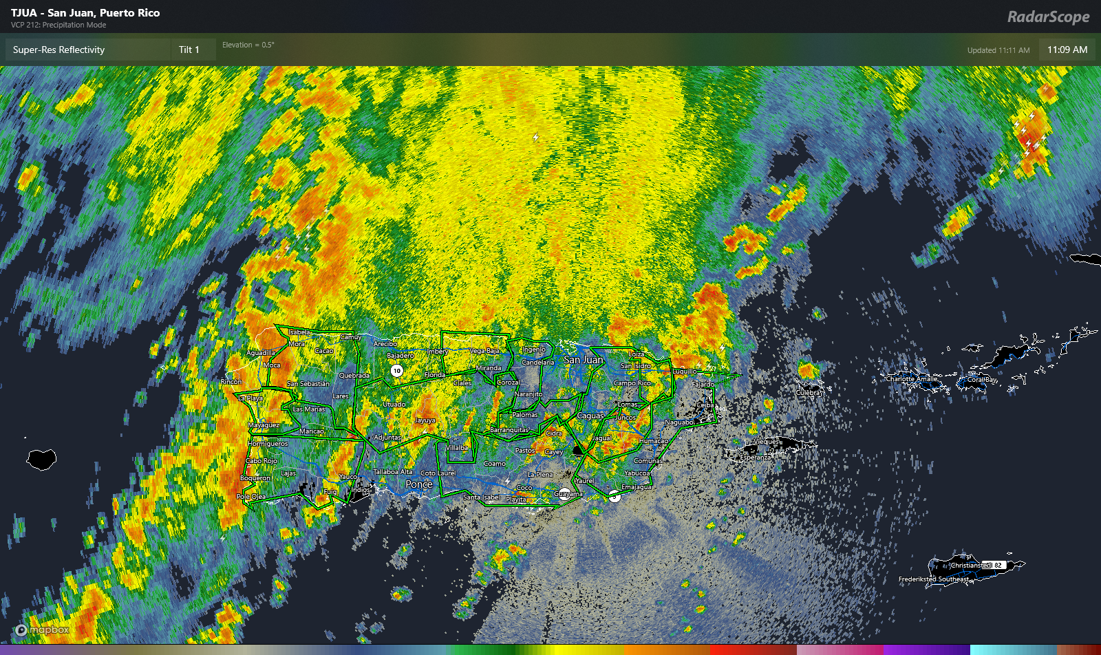
Heavy, flooding rains continue on Puerto Rico with multiple flash flood warnings in effect across the island. (RadarScope)
Upwards of a dozen flash flood warnings are in effect on the island, covering just about every corner. Rain totals are estimated around 8 to 10 inches in the south-central portion of Puerto Rico in the last 24 hours, with another 3 to 6 inches possible before all is said and done.
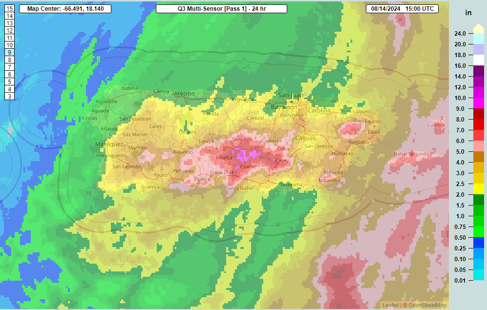
Rainfall estimates have approached 9 to 10 inches in southern Puerto Rico. (NOAA MRMS)
Considerable flash flooding and localized mudslides will remain a threat into late afternoon and evening in Puerto Rico and to a lesser extent the Virgin Islands.
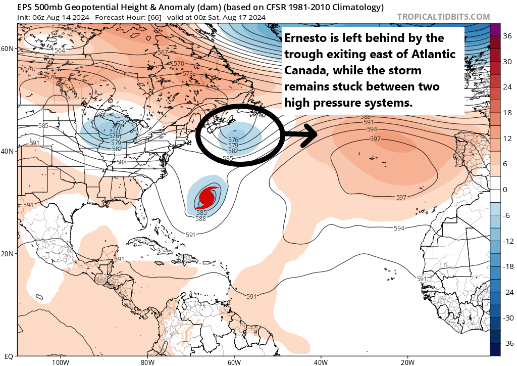
Meanwhile, Ernesto is moving northwest at 16 mph, hauling its way away from the Caribbean. The next question will become how close it gets to Bermuda on Saturday. Ernesto split the gap between two high pressure centers over the Deep South and Atlantic Ocean, and it will follow that gap into a trough off the East Coast. The trouble starts to happen on Friday as Ernesto is moving northeast toward Bermuda. The trough is going to exit the picture, likely leaving Ernesto behind.
Ernesto gets left behind by the trough that exits without it. This will have implications for both Bermuda and Atlantic Canada. (Tropical Tidbits)
Ernesto will begin to slow down at this point, since it will lose the “pull” of the trough. This should allow it to lash Bermuda with heavy rain and gusty winds. Ernesto may be a major hurricane at this point, or at least close to it, so it will probably deliver some pretty meaningful impacts to the island, of course depending on exactly how close it comes.
Ernesto may then get “pulled” back to the northwest a bit by an approaching trough from the Great Lakes. It’s not going to make a hard left into the U.S. East Coast, but this will delay its exit out to sea. At the least, rough surf and rip currents will likely become an issue this weekend and next week on the East Coast. From a land impact perspective, this erratic movement has implications for Nova Scotia and Newfoundland. Instead of exiting into the open Atlantic, the jog back north or northwest could allow Ernesto to eventually smack into Atlantic Canada next week. The exact details and impacts of this are TBD, but suffice to say, I would be watching this closely in the Maritimes.
More to come on this. Meanwhile, the Atlantic continues to look as if a suppressed background state will halt tropical development risk for the next 7 to 10 days behind Ernesto. No additional storms are expected through next week.
Ernesto is moving through the northeast Caribbean as a moderate tropical storm.
It may strengthen into a hurricane as it approaches or passes the Virgin Islands and east of Puerto Rico.
Impacts to Puerto Rico will be mainly heavy rain and flooding on the south and east sides of the island.
Impacts could be a bit stronger for the USVI, Vieques, and Culebra.
Ernesto will then possibly take aim at Bermuda heading toward the weekend.
Ernesto making an effort to intensify
Tropical Storm Ernesto is working through the far northeast Caribbean this afternoon, strengthening in the process. Currently, Ernesto has 50 mph winds and is located just south of St. Kitts and Nevis.
Ernesto wiggling its way toward the Virgin Islands this afternoon (Tropical Tidbits)
Over the next 12 to 24 hours, Ernesto is going to track west northwest toward the Virgin Islands, Culebra, and Vieques. Hurricane Watches have been issued for the US & British Virgin Islands, as well as Culebra and Vieques. Puerto Rico remains under a Tropical Storm Warning, as are a number of other islands in the Leewards. Given the atmospheric conditions surrounding Ernesto, it’s possible that this could become a hurricane in the next 18 to 24 hours as it approaches and passes the islands east of Puerto Rico. By tomorrow afternoon. Ernesto will be north of the islands and conditions will improve.
In terms of impacts, the main threat is probably still rainfall.
Heavy rainfall will impact Puerto Rico and nearby islands to the east, with upwards of 8 inches and flash flooding a good possibility. (NOAA WPC)
Flooding is a good bet on parts of Puerto Rico, mainly on the south and east coasts of the island. Additional heavy rain may impact the US Virgin Islands, Vieques, and Culebra. Lesser heavy rains will impact the British Virgin Islands and other portions of the northeast Caribbean. Obviously, wind will be a bit of an issue, especially north and east of where the center tracks, hence the hurricane watches for the islands just east of Puerto Rico. And rough marine conditions will continue in the northeast Caribbean through tomorrow.
Bermuda bound?
Beyond the Caribbean, Ernesto is likely to turn northwest and then northward, steering clear of the Turks and Caicos Islands, but tracking toward Bermuda. The threat to Bermuda is a potentially serious one. We can examine that closer in the days ahead, but at this point, suffice to say model agreement is good on a track that brings Ernesto very near Bermuda as a hurricane in about 4 or 5 days.
Ernesto is likely to be in the vicinity of Bermuda in about 5 days, with uncertainty in the exact track taking over beyond that point. (Tropical Tidbits)
There are some questions as to how strong Ernesto will get as it tracks toward Bermuda, with the current official forecast keeping it just shy of major hurricane intensity. Modeling has backed off a bit on the high end of intensity as well, but there is always a chance that Ernesto could outpace model forecasts in terms of intensity in the next few days. So for folks in Bermuda, it’s probably a good time to start reviewing your hurricane plans with Ernesto sending a pretty clear message this far in advance.
Beyond Bermuda, there are questions as to exactly how Ernesto is steered which could have implications for Atlantic Canada in time. We’ll review that in more details as we get into tomorrow and Thursday.
The rest of the tropics are quiet with no threats noted.