The tropics refuse to go away quietly, with Pilar in the Pacific and a potential Caribbean system later this week that bears watching in Central America.
Atlantic update: Invest 96L unlikely to do much, but the Caribbean bears watching later this week
We are watching two areas in the Atlantic at the moment: Invest 96L near the Bahamas and a yet-to-develop system in the Caribbean. Let’s run through them.
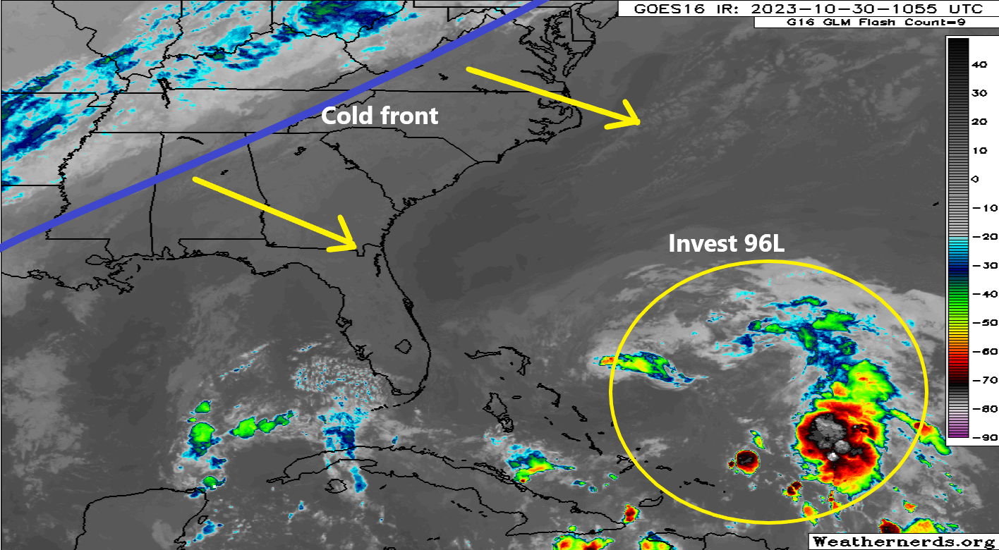
Invest 96L
Though this is the most immediate item on the menu, it’s not the most notable. 96L was found with gusty winds but no real circulation to hone in on yesterday, so it remains just a disturbance. But it’s about to get smacked in the face by dry air and wind shear, as the much discussed significant U.S. cold front comes sweeping offshore tomorrow.
Invest 96L will soon run out of time to develop east of the Bahamas, as a cold front will sweep it away. (Weathernerds.org)
This should knock 96L out to sea and probably prevent any real development at all.
Caribbean
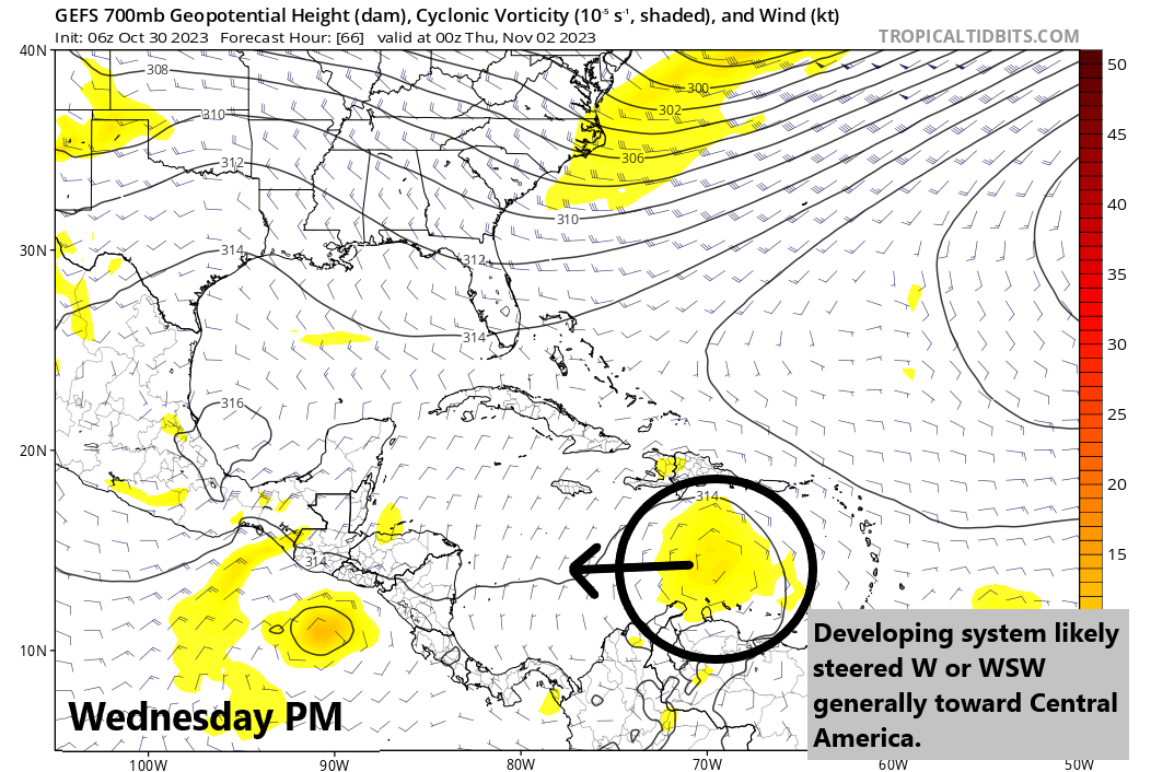
Despite their noisy operational guidance shows, both the GFS and European models are in decent agreement right now that a surface low pressure system is going to form in the Caribbean around midweek. It will drift west in the coming days toward Central America. Both sets of ensembles (which run the models 30 to 50 different times) show a favorable setup for development, but the GFS is tending to run “hot” right now, developing it slowly but intensely as it comes west. The Euro? Not so much. But this has been an issue throughout hurricane season. The GFS does tend to overcook Caribbean systems this time of year, and the Euro has tended to have an underforecast bias when it comes to intensity. To me, that argues for some type of developing tropical system in the western Caribbean by the weekend.
The average of all the GFS ensemble members for Wednesday evening shows a developing system south of Hispaniola in the Caribbean, likely to track due west or even west-southwest. While the GFS operational may be too aggressive at this point, this system will bear close watching in Central America. (Tropical Tidbits)
In general, I would expect this system to be steered generally west, if not even a little south of west around the periphery of sprawling high pressure that will extend from south of Bermuda across the Bahamas toward Cuba and the Yucatan this weekend. Exactly how far west this gets, how strong it gets, and where (if) it makes landfall is to be determined, but interests from the Yucatan and Belize south into Honduras and Nicaragua should probably be watching this rather closely in the meantime. We’ll update with the latest tomorrow.
Pacific Update: Pilar will likely bring heavy rain to El Salvador
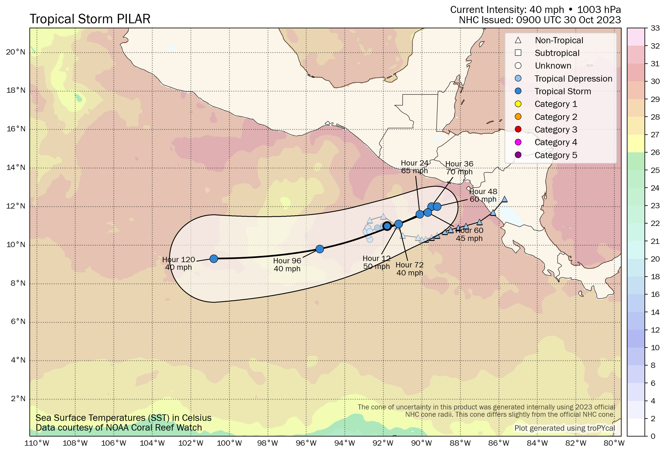
Tropical Storm Pilar formed last night in the eastern Pacific. Over the next couple days it will drift toward El Salvador and Honduras. Tropical Storm Watches are posted there and Nicaragua. Pilar is not currently expected to become a hurricane, and it will primarily bring tropical storm conditions and heavy rain to the Pacific coastal communities between Guatemala and Nicaragua. Heavy rain could cause flooding and mudslides in some of these areas.
Pilar will take a funky track toward El Savador and Honduras over the next 36-48 hours before pulling a 180 and heading out to sea. (Tomer Burg)
Elsewhere in the East Pac, we don’t expect any significant development through the week.
U.S. Weather: Frost & freeze & Santa Ana winds in California
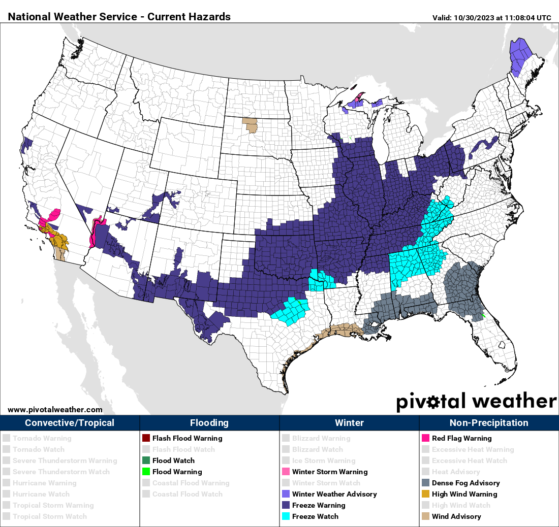
If you look at a National Weather Service hazards map of the U.S. right now, one thing sure stands out: Frost and freeze alerts all over the place. Freeze warnings extend from the Mexico/New Mexico border up into Ohio and Pennsylvania.
Freeze warnings extend from Arizona and the New Mexico border with Mexico up into Pennsylvania this morning. (Pivotal Weather)
Some cold nights are ahead this week with the first true wintry-type air mass of the season across the Lower 48.
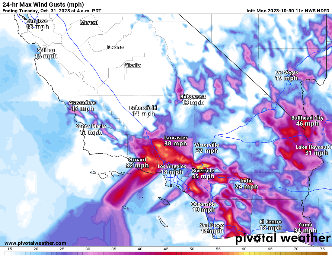
And as is often the case, when cold air dumps into the Rockies and points east, Santa Ana winds are kicking up in California, leading to warm weather and critical fire danger today, particularly in the higher terrain around Los Angeles and into Ventura County.
A fairly classic Santa Ana wind pattern across metro SoCal today. The strongest winds and highest fire danger today will be in the mountains around LA, as well as in Ventura County. (Pivotal Weather)
We’ll hope for nothing serious in that part of the country. Winds should settle down on Tuesday.
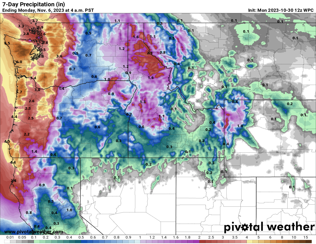
Otherwise, it looks like a relatively quiet week nationally. A storm will enter the Pacific Northwest around Thursday, bringing heavy rain and mountain snow. Snow levels will be relatively high with these storms. That may be followed by a second or third system this weekend.
Mostly welcome precipitation over the next week will be fairly considerable from northern California into the Northwest, though snow levels will be a bit high. (Pivotal Weather)
We’ll be watching the western Caribbean next week for potential development, though any details and specifics are impossible to hone in on just yet.
Tropical Update: Tammy’s ghost, Pacific 92E meanders, and watching the western Caribbean
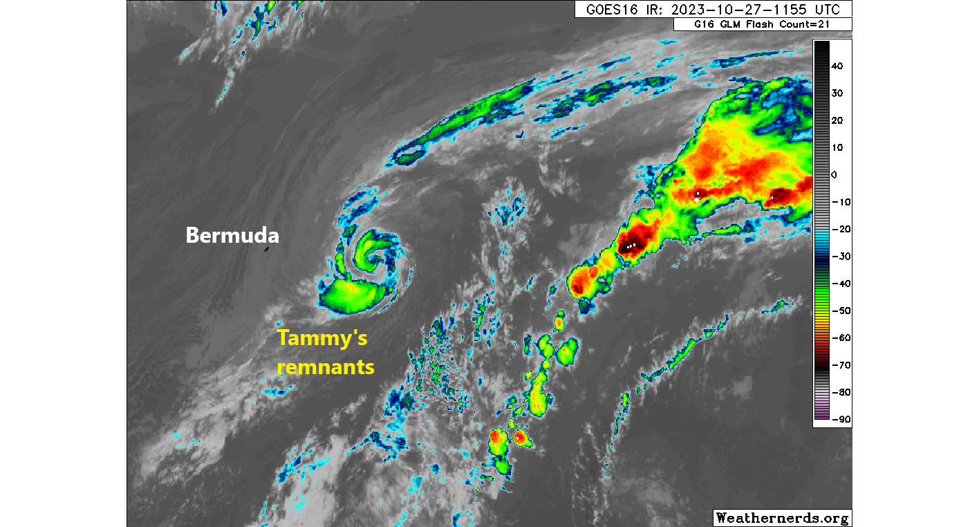
Tammy’s remnants continue to swirl in the Atlantic this morning, with expectations that it will bend back to the east and out to sea. It is likely to regenerate into a tropical entity today or tomorrow. I wouldn’t say it bears watching, but it could be around in some capacity for awhile in the open Atlantic.
The remnants of Tammy are expected to regenerate into a tropical system today or tomorrow as it meanders generally to the east in the Atlantic. (Weathernerds.org)
Meanwhile, in the Pacific, Invest 92E is expected to develop over the next several days off the coast of El Salvador. This is not an area with a lot of history of tropical systems. A few smaller systems have impacted El Salvador in the past, mostly tropical storms. However the track forecast for 92E is rather uncertain still, with possibilities of out to sea, a track toward El Salvador or even Nicaragua, or even a drift northwest toward Guatemala or far south Mexico. The current best odds seem to favor a meander offshore of Central America. There will be a reflexive temptation to compare 92E to Otis due to its proximity and south/east placement, but initially there do not appear to be any meaningful similarities. That said, waters here are warmer than average, which will only help with development. Something to watch heading into next week.
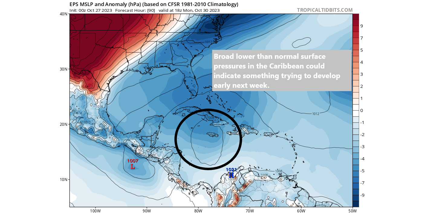
Elsewhere, we continue to see rumblings in model guidance toward something trying to develop in the western Caribbean later next week. It’s too soon to say anything with any confidence or certainty, but this would be a place to watch in early November traditionally.
Sea level pressure is expected to be below average in much of the Atlantic, including the Caribbean next week. This could yield development of a tropical system in the western Caribbean, a favored area for this in early November. (Tropical Tidbits)
We’ll watch trends this weekend and report back with the latest on Monday.
U.S. Weather: Winter takes hold for a few days in much of the country
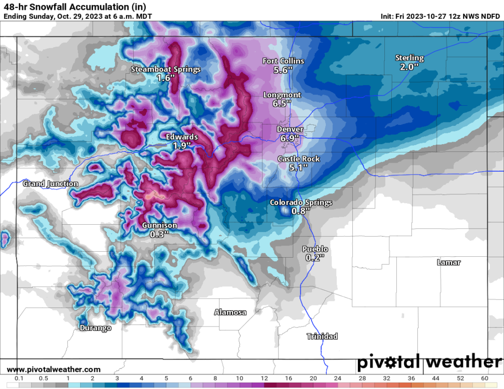
The main weather story is precipitation, with heavy rain in the south-central and heavy snow in the north. Snow is likely tomorrow across much of Nebraska, as well as in the Rockies. Snow will spread into the Denver area on Saturday night and into Sunday.
Snow totals of 6″ or more are possible in Denver and in the Front Range, with a band of 2 to 5 inches of snow expanding east-northeast from there across Nebraska into Sunday. (Pivotal Weather)
To the south, it’s rain. Yesterday, we noted radar estimates of 9”+ in parts of Texas. More heavy rain fell Thursday in the I-35 corridor and points east to just northwest of Houston. There was even a reported tornado in San Antonio. Additional rain today could cause localized flooding issues.
Rain and localized flooding is possible today from north of Austin to Dallas and into southeast Oklahoma. (Pivotal Weather)
The highest risk of flash flooding today is probably between Waco and DFW.
That risk of rain will expand north and east as well, focusing southeast of the Tulsa area, much of northwest Arkansas, and southern Missouri tomorrow. Similar areas will be at it on Sunday. Finally, that cold front helping to cause the unsettled weather will shift east after Sunday and Monday, ushering in our first real true Arctic air mass of the season, which could produce record lows next week.
Record lows next Wednesday morning (boxed) may occur from Abilene and Dallas up into portions of the Ohio Valley. (Weather Bell)
Temperatures are forecast to be in the teens in Kansas City, 20s in Oklahoma City, and mid-30s in Dallas on Wednesday morning, all possible record lows.
Scroll to the bottom for a couple notes on current weather, but in today’s post, I want to try to make some sense of what just happened in Mexico this week.
Otis’s catastrophic rapid intensification: What happened?
In general, I think Eric did a good job yesterday sort of conveying the general shock many of us in the meteorology community had with regard to Hurricane Otis. The word “unprecedented” gets tossed around a little too fast and loose these days, but truly, this was without any real precedent in Acapulco. And it was with only slight precedent anywhere in terms of how quickly it intensified.
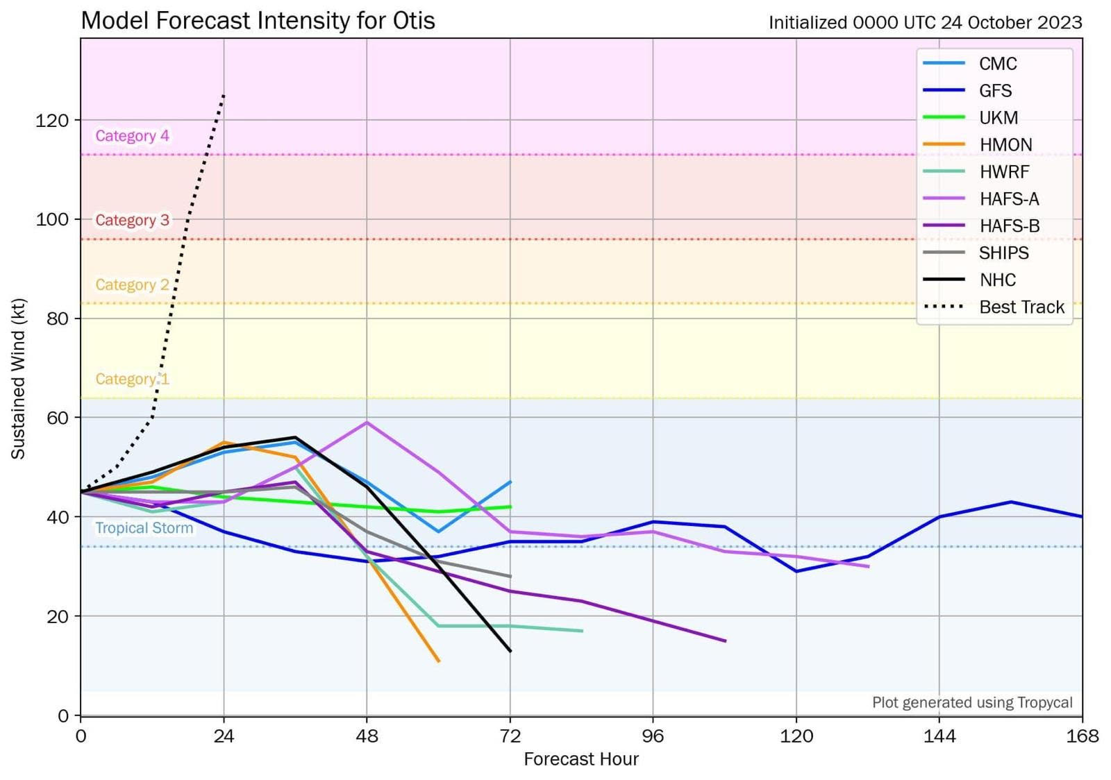
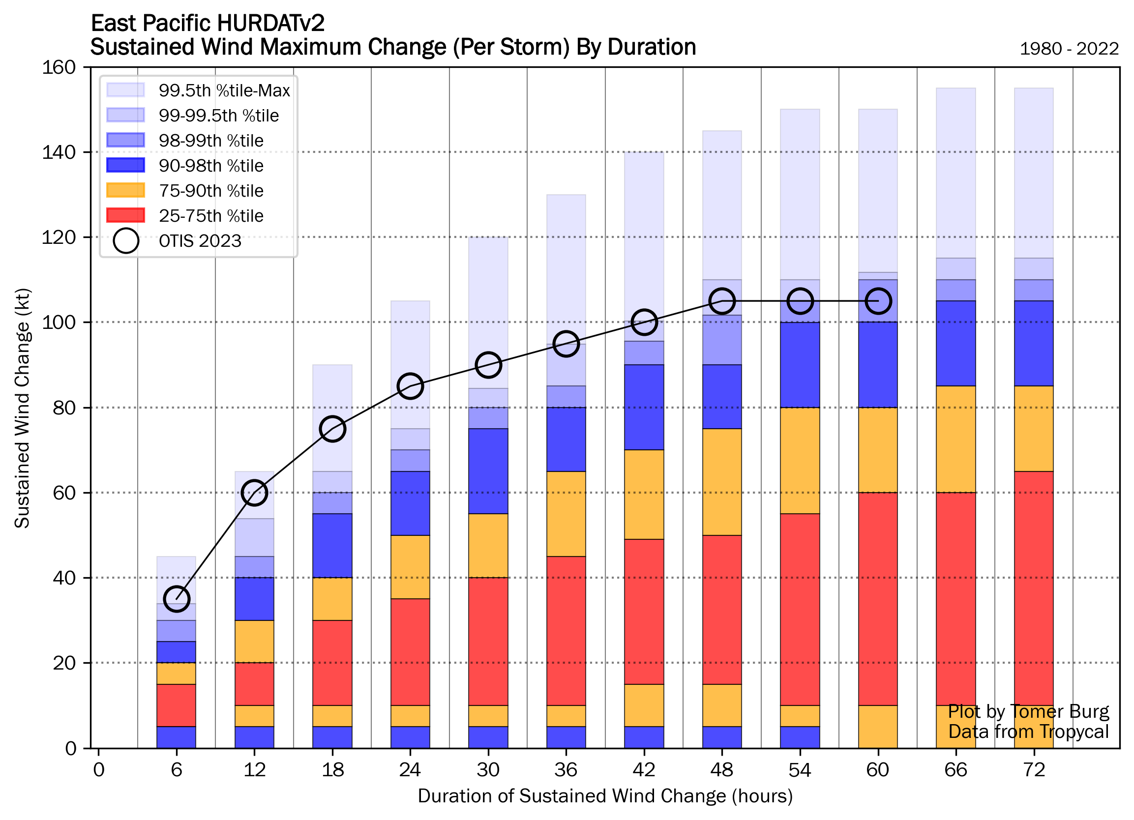
Otis was the textbook definition of rapid intensification (RI), going from a 50 mph tropical storm on Monday evening to a 165 mph category 5 hurricane last night. Look at the change in Otis between Sunday evening and Tuesday evening, 48 hours apart. You can see the intensification chart to the right of the satellite loop. Through about mid-morning on Tuesday, everything was going basically as you’d expect for a modest hurricane with Otis. It may have been tracking toward a category 2 type landfall, or even a category 3 type landfall in a worst case, if you assumed the general rules of RI in this region.
Much like an onion, there are layers to this story that are important. First, take it from one of the more seasoned hurricane hunters, this was not what they expected when they flew their mission on Tuesday.
And this was before Otis had peaked. The typical satellite-derived intensity values often used to “proxy” intensity of storms that are far away from reconnaissance flights failed in this case to grasp how intense Otis was. In other words, Otis intensified so quickly that it basically outran the ability to measure how intense it actually was.
Here was the raw model output for Otis from Tuesday morning. This is what general weather forecasters would use to assess what the models assume will happen with a storm’s wind forecast. The dashed line is what actually occurred.
Otis’s model forecasts on Tuesday early morning were nowhere remotely close to what happened. (Tomer Burg on Twitter)
None of the best, most reliable tropical modeling had Otis as a hurricane, let alone a category 5 storm. To put it bluntly, this was an absolutely catastrophic forecast failure.
Even the National Hurricane Center by late Tuesday morning had it at 90 mph making landfall, well above any forecast data, and they concluded in their discussion that it seemed reasonable to potentially see further intensification adjustments before landfall. So even in the worst case scenario, the NHC forecast would have still been off by probably two categories less than 18 hours before landfall. And this was using strong meteorological analysis to bias correct the models upward too. And to their credit, they had it at 140 mph by the late afternoon advisory.
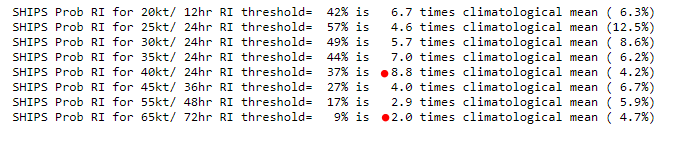
Interestingly, one of the tools we use to forecast the probability that a storm will rapidly intensify, SHIPS guidance, failed also. Early on Tuesday morning it only showed about a 2-3x above normal chance that the storm would intensify from a 50 mph tropical storm to a 100-125 mph hurricane. Yes, that is above climatology, but it’s not exactly anything impressive given what we’ve seen in recent years.
By Tuesday afternoon, those odds had increased to 5-9x above normal. But even this only showed 2x above normal odds that we’d get to 140 mph+. There were finally some hints available by mid to late morning on Tuesday, but nothing that would have offered a meaningful forecast improvement over what the NHC had (which called for 20-30 mph of intensification over 12-24 hours).
SHIPS rapid intensification forecast guidance from Tuesday midday showed about 9x greater than normal probability of 50 mph of intensity gain, which at that point would have meant a category 2 or 3 storm. The odds of something truly massive were still only about 2x above normal. (UCAR)
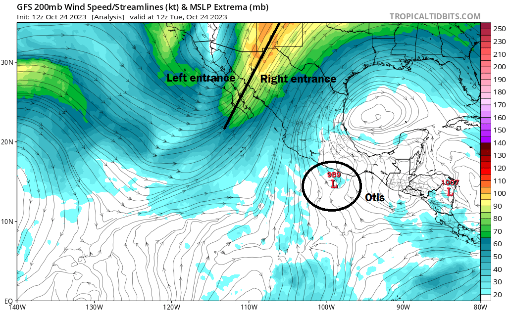
So the first question is, why did Otis do what it did? Probably a combination of a couple things. First, Otis was placed ideally in an environment that facilitated constructive wind shear. When we discuss wind shear it’s usually referenced in a negative sense; wind shear inhibits and destroys storms. Well, in occasional cases, as we’ve witnessed in the Gulf with Ian, Delta, Zeta, among many other storms in recent years, the wind shear can actually be constructive and help ‘vent’ the system. In this case, Otis was optimally placed in the right entrance region of the jet stream.
An analysis map from the GFS model showing jet stream winds on Tuesday morning. Otis (circled) is tenuously placed in the right entrance region of the jet stream, which tends to offer a more favorable environment for intensification. (Tropical Tidbits)
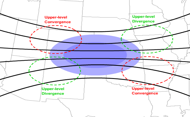
Storms are aided in intensification when placed in the left front or right rear (entrance) of the jet stream. Why? In that portion of the jet stream, the winds aloft diverge, meaning they either are moving in opposite directions or stronger wind is diverging away from weaker wind. Upper level divergence leads to rising air. Rising air is necessary for storms to form and maintain, and thus surface pressures tend to fall in this region of the jet stream as well.
A conceptual model of a jet streak showing that the right entrance region (bottom left quadrant) is supportive of upper level divergence and surface pressure falls (Penn State University)
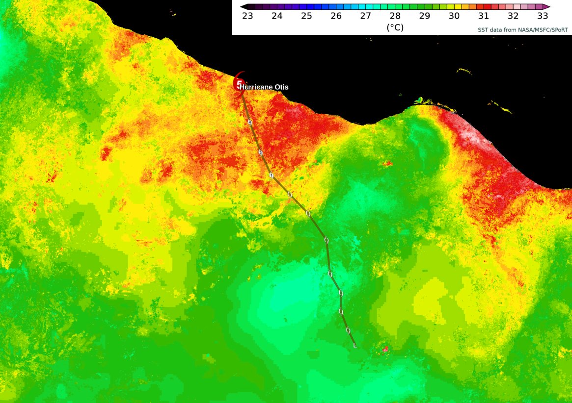
Otis wasn’t exactly square in the middle of the right entrance region, but it was there. Additionally, Otis tracked right over an area of 31°C sea surface temperatures.
Sea surface temperatures were close to 31°C over Otis’s path, which is a few degrees above normal. While not the primary cause of Otis’s rapid intensification, they did not hurt. (Brian McNoldy on Twitter)
This rich warm water did not hurt matters at all.
So how did every reliable model we use miss this? That’s for graduate students and researchers to answer in the coming years, because I have no formal idea. There was something about Otis that models just could not capture and translate to RI. Human forecasters, recognizing the setup were able to mitigate some but not all of the underforecast issue. Otis’s smaller size may have also contributed. My hunch is also that if Otis had tracked, say 30-40 miles east or west of where it was, it would not have gone off to the races like this. It was simply perfectly placed to optimize intensification.
A less sexy explanation? Otis was almost unprecedented in the historical record. Only Hurricane Patricia in the Pacific in 2015 had a greater rate of RI than Otis. And in the modern era no massive storm has hit Acapulco.
Otis was not the fastest rapidly intensifying storm on record, but it was near the top of the list in the East Pacific, lagging only 2015’s Patricia. (Tomer Burg on Twitter)
Unprecedented outcomes are just that, and if the historical record has only one other remotely comparable event in this region, it becomes tough to expect that modeling can “capture” the concept that this would occur in this environment.
It feels like this was a combination of bad luck, bad timing, and bad placement. And it just so happened that a metropolitan area with over 1 million people was in the way.
It’s easy to sit here and pontificate about this or to say that weather forecasts are often wrong. But the thing is, they’re not. They’re often right. With hurricanes, forecasting has improved by leaps and bounds in the last 20 to 30 years. Perfect? No, but often more than acceptable. A failure like this shocks us because we aren’t actually used to forecast failures of this magnitude anymore! 100 years ago? Sure, this was fairly routine. But in the 2020s, we have standards and expectations for weather forecasts, and clearly this was a shock to the system. Busts like this remind us that it’s an imperfect business and there is still much work to do. The work to be done to understand Otis will take time, but we will certainly see many research papers in the coming years.
Weather update: Tammy, Texas rain, and continued wintry weather north
Just a quick punch list of items we’ll be watching over the next few days.
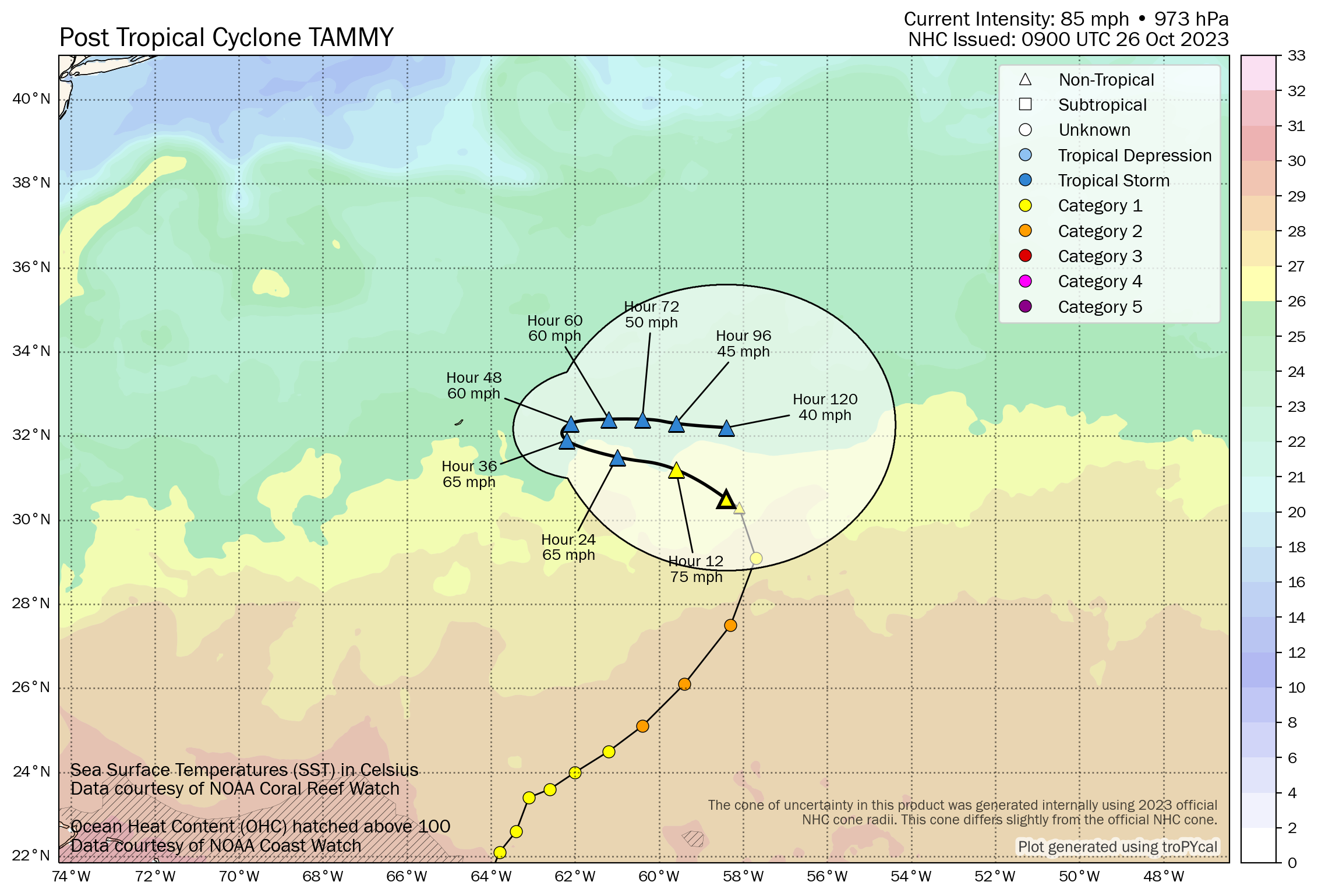
Hurricane Tammy’s final advisory was issued this morning, as it has transitioned into an extratropical entity, or something akin to a strong nor’easter. It will meander east of Bermuda for a few days, and there is some chance this could reacquire tropical characteristics at some point. It won’t go quietly, but hopefully any impacts to Bermuda are minimal.
Post-tropical Tammy will remain a strong storm for several more days as it meanders east of Bermuda. (Tomer Burg)
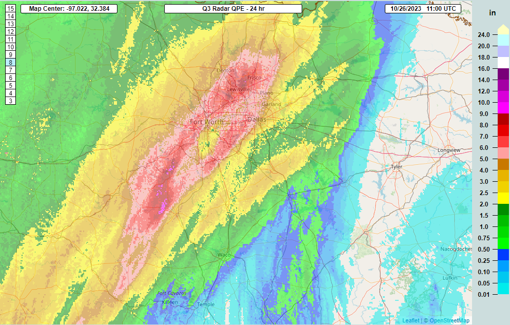
Flash flooding concerns will be in the forecast in the southern Plains over the next few days, meandering from Texas into Arkansas. Generally 3 to 5 inches of rain is possible in spots. But higher amounts are a virtual certainty. South of Dallas, the 24 hour rainfall totals in Hood and Somervell Counties are estimated to be close to 10 inches.
Rain totals southwest of Dallas and Fort Worth are estimated to be close to 10 inches (purple) over the last 24 hours. (NOAA NSSL)
Numerous flash flood warnings are posted in North Texas and Hill Country this morning as heavy rain falls and spreads south and east.
Snow will continue in the northern tier. Over a foot fell in Helena, Montana, with snow spreading into North Dakota. Snow should wind down tonight from west to east.
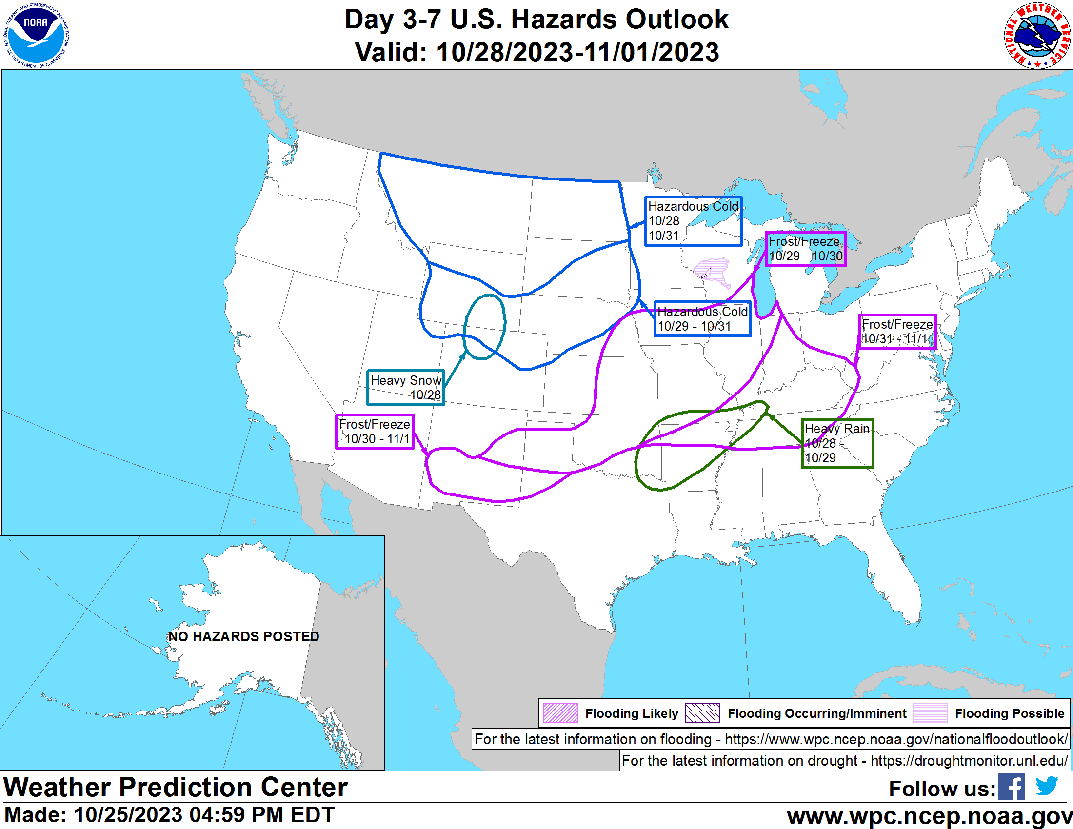
A bunch of items will impact the interior U.S. over the next 3 to 7 days, ranging from heavy snow in the Rockies to heavy rain in the mid-Mississippi Valley to hazardous cold in the North. (NOAA WPC)
The hazards map from the Weather Prediction Center is lit up for days 3 to 7 with cold infiltrating from Canada this weekend in the North, the aforementioned heavy rain in mid-Mississippi Valley, and frost and freeze risk from near the Permian Basin and southern New Mexico across to the Ohio and Tennessee Valleys. We’ll have more tomorrow!
We are going to talk about Otis today because of the hurricane’s dramatic intensification on Tuesday, and overnight landfall along the Southern Pacific coast of Mexico.
Rapid intensification
Otis made landfall on Tuesday night, near Acapulco, with maximum sustained winds of 165 mph. This was a worst-case scenario for this region. Why? Because no storms had been recorded in this area, this strong, before. On top of that, local residents and business owners had less than a day to prepare for the worst hurricane of their lives. So not only was this storm unexpected, there was no institutional memory about what to expect from a major hurricane.
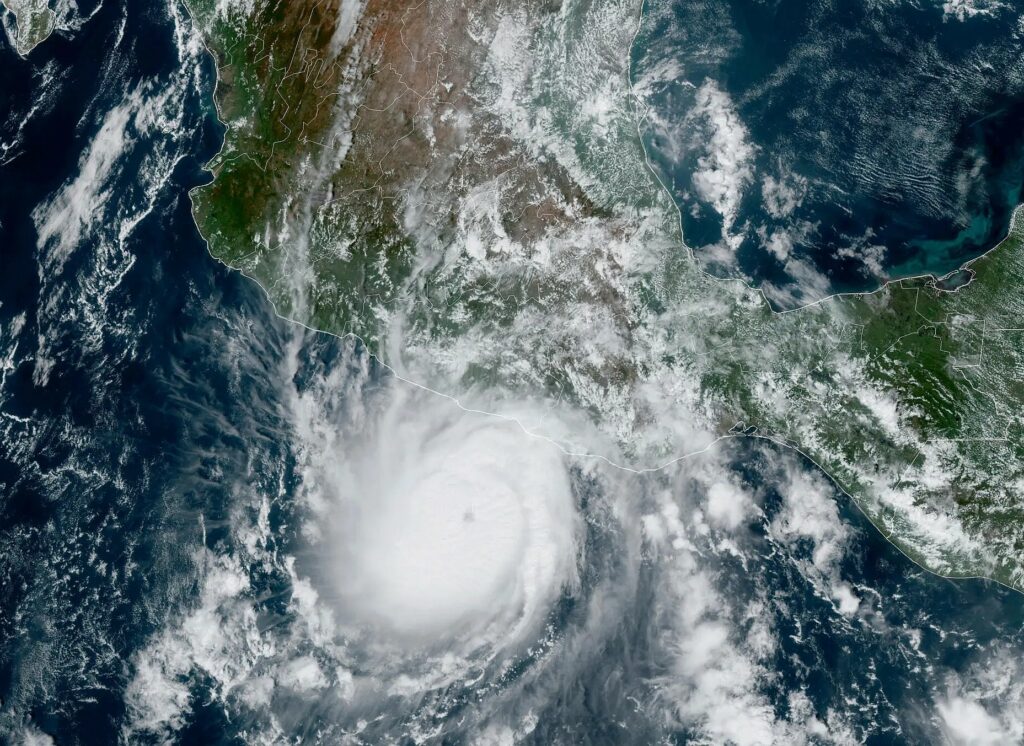
Hurricane Otis nears the southern coast of Mexico on Tuesday. (NOAA)
With this startling burst in intensity, Otis has nearly set a record for rapid intensification within 24 hours. The system strengthened from a 50 mph tropical storm at 1 am CT on Tuesday to 165 mph just 23 hours later. That is 115 mph in 24 hours. It is second only to Hurricane Patricia, a Pacific storm in 2015 that saw its maximum sustained winds increase by 120 mph during a similar period.
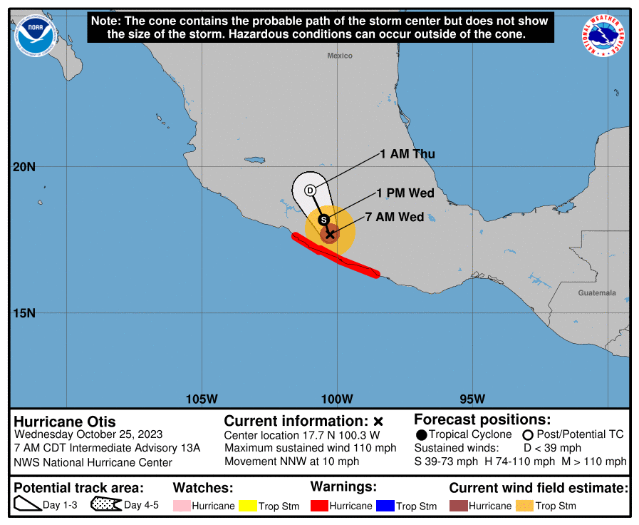
This morning, as it moves inland, Otis is weakening. As of 7 am CT the storm had 110 mph winds, and will continue to lose intensity as it interacts with mountainous terrain. Nevertheless, Otis will continue to bring damaging winds into Southern Mexico today, along with dangerous storm surge. Heavy rains will remain a problem later this week, through Thursday, for much of Southern Mexico. They are likely to produce significant flooding and mudslides.
Forecast track for Hurricane Otis. (National Hurricane Center)
Completely blind-sided
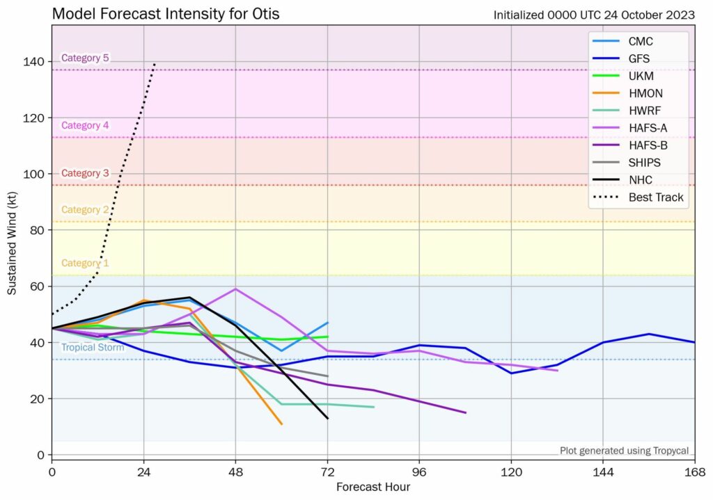
Let’s wind things back to Monday night, and have a look at the model forecasts for the intensity of Hurricane Otis. At the time this was a tropical storm, and largely expected to remain so before its landfall into Mexico. None of our ‘best’ models for predicting tropical system intensity anticipated Otis growing beyond tropical storm-strength. In two decades of forecasting I do not recall a whiff like this one.
A plot of intensity forecasts for Hurricane Otis. (Tomer Burg, Blue Sky).
As a meteorologist, these kind of moments are humbling. Otis will be studied in the coming months and years to understand why it blew up so quickly, and so powerfully, in such a short period of time. In moments like these, forecasters utterly failed the people of Southern Mexico. We must do better.
Hurricane Tammy
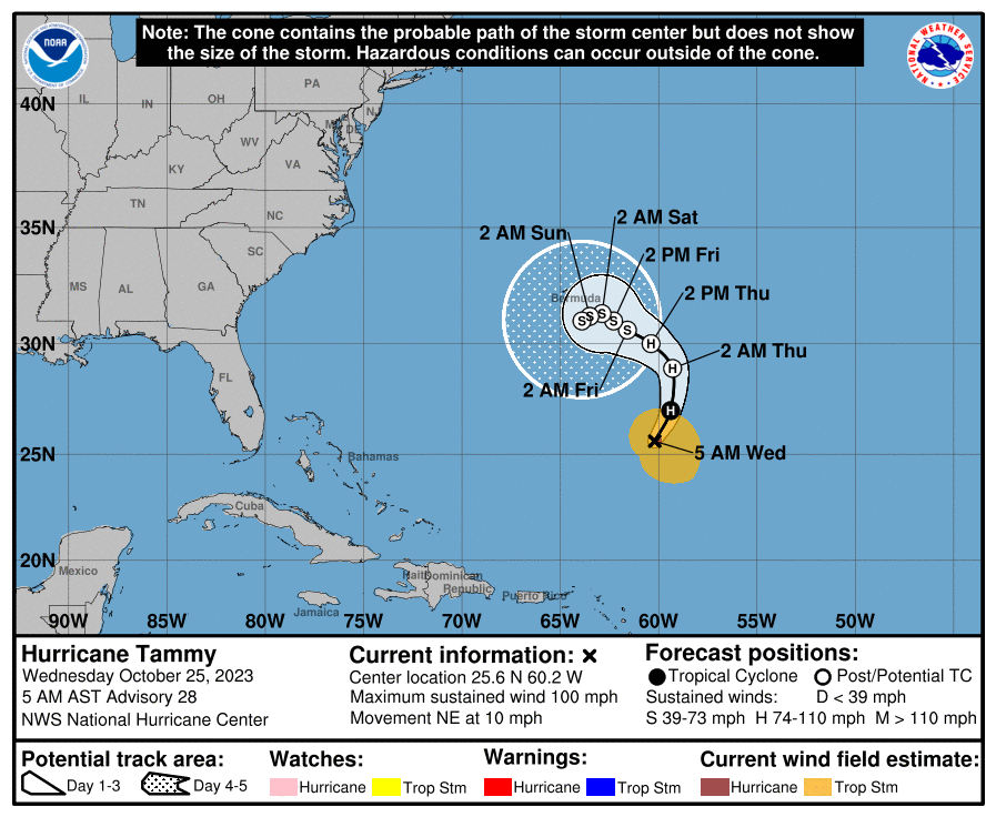
Over in the Atlantic Ocean, Hurricane Tammy continues to dance around the Atlantic Ocean. This storm would be a curiosity given its meandering track, but for its potential to come near Bermuda this weekend. As of Wednesday morning, Tammy has sustained winds of 100 mph, and there is a chance for some slight strengthening today.
However, after today it is likely to interact with a cold front, and begin a transition to a non-tropical storm. There is a fair amount of uncertainty in track and intensity. But for now it looks like Tammy will remain far enough south, and just weak enough, to not bring anything more than garden-variety like storminess to Bermuda this weekend.
Tammy is going to have a walk-about in the Atlantic this week. (National Hurricane Center)
Beyond Tammy, happily, the Atlantic tropics look quiet.