Today we’ll touch on some rain in the West, an update on the eclipse cloud cover outlook, and have some comments on early hurricane season outlooks.
Headlines
- Moderate SoCal flash flooding risk with one of the wet season’s final big storms.
- Still signals for a storm system “in the neighborhood” of the path of totality for April 8th’s eclipse, but confidence is not really any higher.
- AccuWeather released their hurricane season outlook on Wednesday, calling for 20 to 25 named storms and 8 to 12 hurricanes, a very active season.
It does rain in Southern California
Let’s begin out West where a gnarly late season series of storms is helping to “top off” California’s snowpack and deliver one more round of rain to Southern California. One storm is exiting the Sierra today. The next one actually tracks southeast along and off the California coast, where it will bring a round of heavy rain and chance of thunderstorms to SoCal.
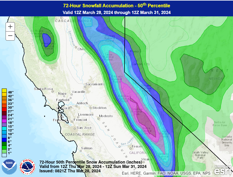
As far as rain goes, it looks like the LA Basin will do well in this one with an inch or two of rain for most. Heavier totals (and some snow, with snow levels perhaps as low as 4,500 feet at times!) will be possible in the LA County and Ventura County mountains, as well as out toward Santa Barbara. San Diego will also do well in this one with 1 to 2 inches of liquid expected. Isolated higher amounts are possible, as is flash flooding in some of these areas.
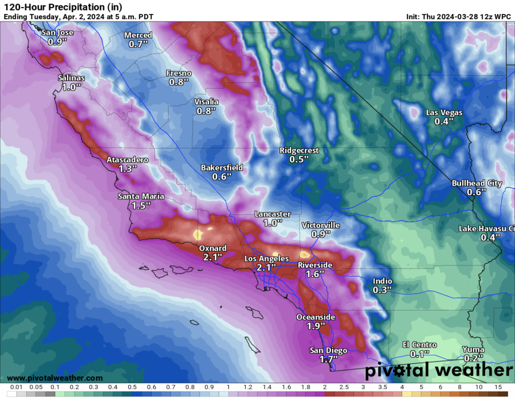
The storm hits Saturday and exits later Sunday, setting up perhaps some quieter weather next week. In addition to rain, there will be some thunderstorms with perhaps the usual California rogue, localized tornado possible.
This storm will emerge in the Plains next week and bring the potential of locally heavy rain and even some more snow to parts of the Central and Eastern U.S., including snow or ice potential in New England next Wednesday or Thursday.
Do we know anything further about the weather for April 8th’s eclipse?
Do we have any clarity on the forecast for the solar eclipse today? Not really. Back on Monday we noted that model ensembles were suggesting a storm exiting the Rockies and some noteworthy precipitation probabilities on the Gulf Coast and in the Midwest. Everything remains pretty status quo today versus Monday.
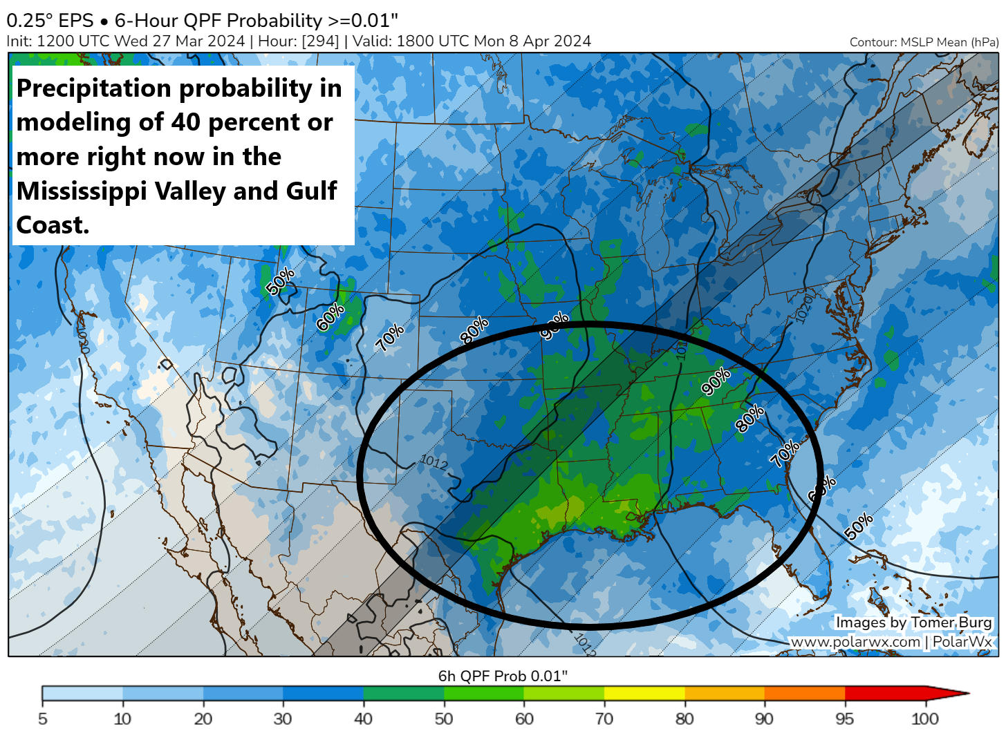
Keep in mind that higher rainfall probabilities do *not* necessarily mean it will be overcast. As is often the case, we could have scattered or broken clouds which could still allow for eclipse viewing, even if rain chances are relatively high.
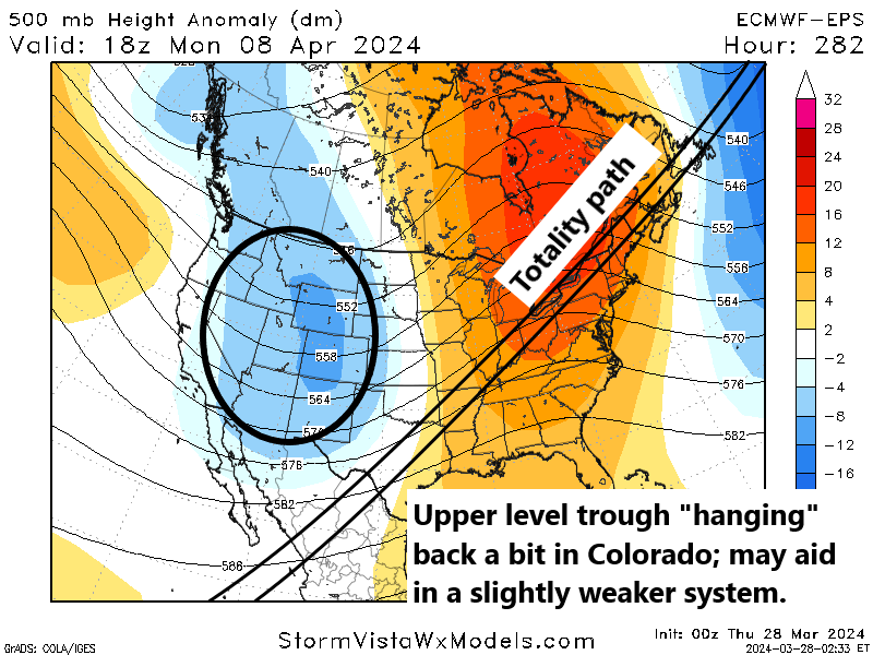
If we could say something of note that’s changed, I might point to the expected system exiting the Rockies. Overall, 500 mb heights are a little less low, which indicates that perhaps the storm system emerging will be a bit weaker? Too soon to say much in that department. But suffice to say that things have not trended much worse since Monday, so that’s good news at least.
Also, shout out to Tomer Burg and StormVista for enabling the eclipse path overlay on their sites. Helpful!
I know some people think this exercise is silly; Matt, you’re devoting a whole section of your post to say “we don’t know.” And you’re correct, we are doing that. But the interest in this forecast is astronomical (pun intended). We are here to give the people what they want!
Anyway, let’s check back in on this on Saturday or Monday.
Here come the big hurricane season outlooks
According to the Barcelona Supercomputing Center’s aggregator of seasonal hurricane forecasts, we have had two as of yesterday: Weather2020 predicts 14 to 19 storms and 8 to 10 hurricanes. StormGeo predicts 21 named storms and 11 hurricanes. Yesterday, AccuWeather published their forecast calling for an “explosive” (their words) hurricane season in the Atlantic. They project 20 to 25 named storms and 8 to 12 hurricanes. They also go on to note that their analog years suggest the Texas coast, Florida, and the Carolinas are at a higher risk than usual this year. Analog years can be fickle, and recall that it is difficult to predict exactly who will get hit before the season begins. Just last year, AccuWeather noted that the entire Florida coast and Southeast coast was at a higher risk than usual, with a lower risk in the Northeast and Texas. While Florida did see Hurricane Idalia and the Carolina coast Tropical Storm Ophelia, the Northeast flirted with Hurricane Lee, while Texas saw Tropical Storm Harold. My point is analogs can produce mixed results.
I don’t take issue with their forecast at all. I do take issue with using the word “explosive” to characterize it for a headline, but that’s a battle we’ll probably continue to lose.
Anyway, we warned you earlier in the month that as these forecasts are released, they will likely be big. AccuWeather is the first major forecaster to tee one up. The next one up should be Colorado State University, generally the gold standard of these sorts of things. Their first outlook will be released next Thursday. We will have a full recap of that next week. Continue to expect some bulled up forecasts.
I’ve come to find that ‘Accu’ in their name doesn’t represent accuracy. It stands for ‘Accustom to hype’
So by highlighting the gulf coast, Florida, and the Carolina coast… they are effectively highlighting about 80% of historical landfall locations. That is like saying “it will snow in the winter north of Houston”. Doesn’t take much science to figure that out.
I derisively subtweeted about that yesterday ha. In reality, they do state that it’s *relative to historical average* so I get it. But yes, if you had to highlight 3 places using historical climatology, those would be it!
looking forward to CSU’s take… 😊
so glad we have Matt, Eric & the Eyewall here to help us understand things this year 💗
🌬 ⚘⚘⚘
Thank you for this report. Living on the Gulf Coast FL Panhandle, Hurricane season is always of concern. Is there a chart or graph somewhere which compares the best predictions against what actually occurred that season? I refer to NOAA and CSU. Not sure which others should be taken seriously.
In my own personal opinion, you’re doing it right already. That said, I believe there is a way to look back at historical metrics from some other providers for storm numbers. However, when it comes to landfall guesses, that would be a lot harder to quantify.
“Explosive” has to be Bastardi’s word. Take it with a grain of salt.