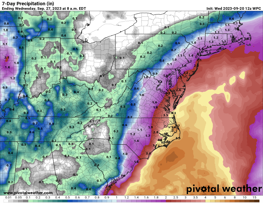
Overall things don’t look too concerning for late September, as Tropical Storm Philippe continues to be a fading force, and Invest 91L appears most likely to track north of the Caribbean Sea and its islands.
Happening Now: Some pesky storms
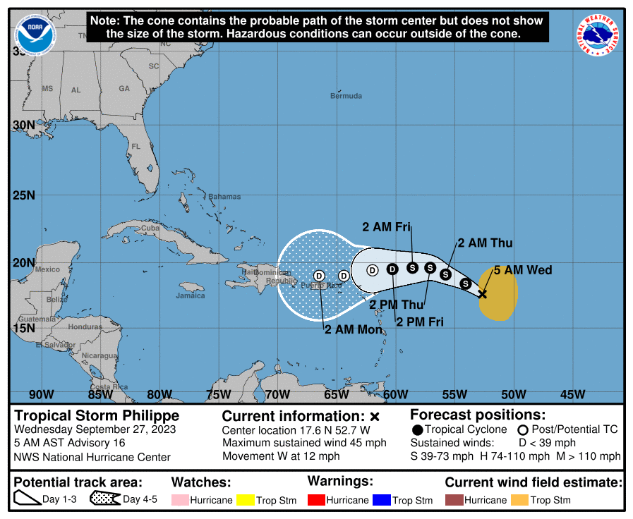
Let’s begin with Tropical Storm Philippe. Frankly, it does not look like much of a tropical system this morning, as the storm is battling against both the influx of some drier air as well as wind shear. This is kryptonite for a tropical storm, and the most likely outcome is that Philippe will dissipate over the next day or two. By this weekend a remnant low should approach Puerto Rico, bringing some elevated rain chances. But I am not seeing anything in this forecast that particularly concerns me.
Au revoir, Philippe? (National Hurricane Center)
Just behind Philippe in the Atlantic lies Invest 91L, which should become the better organized system over the next couple of days. It probably will become Tropical Storm Rina fairly soon as it tracks across the Atlantic Ocean toward the Caribbean Sea. Fortunately, the preponderance of our modeling suggests that this tropical system will mostly likely turn north before reaching the northern Leeward Islands. The continued evolution of 91L will be worth watching, but again it is not something which provides us too much concern at this time.
The medium range (days 6 to 10): Bahamas high jinks
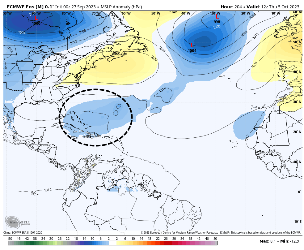
We’re getting to the point of the forecast that is more speculative. However, after the remnants of Philippe move into Puerto Rico and Hispaniola, there may be an opportunity for some sort of low pressure system to congeal in or near the Bahamas about one week from today.
Area where there is some (slight) potential for development next week. (Weather Bell)
There is a definite signal in some of the global models ensembles for this scenario, and the ocean waters are plenty warm in this area. But the signal is not particularly strong, so I would not put too much stock in it. As we get to the end of September, this is the kind of thing we sometimes see in the tropics, with systems spinning up closer to land. If such a system were to develop it probably would get drawn north, perhaps toward Florida or the Eastern United States. But that is super speculative at this point.
Fantasyland (beyond day 10): Some noise, but not a whole lot
When we look even further into the future, well into the first week of October, there’s just not a whole lot out there. We’ll continue to watch the area near the Bahamas mentioned above, as well as the southeastern Gulf of Mexico for potential development. But again this is all pretty vague, and we can’t point to any specific threat. In my book, that’s a good thing.
Two systems are worth watching late this week or weekend, a deep Atlantic Cabo Verde wave and a subtropical system off the coast of the Southeastern United States.
Happening now
There’s not much beyond the slowly fading Hurricane Nigel, which is making a turn to the northeast and will race out to sea harmlessly. It should become a tropical storm in a day or two, and then transition to a post-tropical cyclone as it encounters much colder waters over the Northern Atlantic Ocean. Nigel was the kind of storm we can all live with, a powerful beast that remained at sea and never threatened any landmasses. Would that they all were that way.
The medium-range: Two things to watch
Let’s start with the system closer to the United States, an area of low pressure off the coast of Florida in the Atlantic Ocean. This system may develop into a subtropical storm by around Friday, at which point it is likely to get pulled north toward the Carolinas and Virginia. This will bring a surge of moisture into the region, some high surf, and wind gusts perhaps in excess of 40 mph along coastal areas of North Carolina and Virginia.
NOAA rainfall forecast for now through early next week. (Pivotal Weather)
Probably the biggest threat this weekend to the Southeastern United States coast will come from heavy rainfall, most likely during a period from Friday through Saturday night, with some locations possibly seeing 4 to 6 inches. Tropical rainfall like this can come in bunches, so there will very likely be some localized flooding concerns regardless of whether this system develops or not. By Sunday, whatever this becomes should be pulling hard, away from the eastern coast of the United States.
African wave
As for the African wave, it only recently moved off the continent into the eastern Atlantic Ocean. Over the next few days it should find conditions well suited to further development, and it’s likely to become a tropical depression or possibly even a tropical storm by this weekend. After that? Well, that’s the big question.
The system should move more or less westward through the early part of next week. It seems fairly likely that the storm will get close to the Lesser Antilles, and perhaps Puerto Rico, about seven or eight days from now. At some point it will find a weakness in the high pressure ridge to its north, and lift away from the islands into the open Atlantic Ocean. But since this turn is not likely to occur for at least a week, and perhaps longer, our confidence in the details is understandably low.
This wave may, or may not, threaten the Caribbean Islands next week. (National Hurricane Center)
The bottom line is that this system is worth watching, particularly for places like Antigua and Barbuda, the Virgin Islands, and Puerto Rico. This storm could miss these islands, certainly, but we’re also looking at the possibility of a significant hurricane coming calling. We’ll track it on a daily basis for you right here.
Fantasyland (day 10 and beyond)
There’s not much to see here, especially as concerns tropical weather close to land. That’s just fine with me.
Hurricane Lee is slowly starting to weaken, but remains a large and powerful hurricane as it turns northward on Wednesday morning and it will eventually bring significant impacts to parts of eastern New England and Atlantic Canada this weekend.
Current status of Lee
As of 8 am ET on Wednesday morning, Lee has sustained winds of 115 mph and is moving to the northwest at 6 mph. In terms of timing, it will bring impacts to Bermuda starting late tonight through Friday, and then into New England and Atlantic Canada by later on Friday and Saturday. By that time Lee will be weakening, but should still pack a punch given its large size.
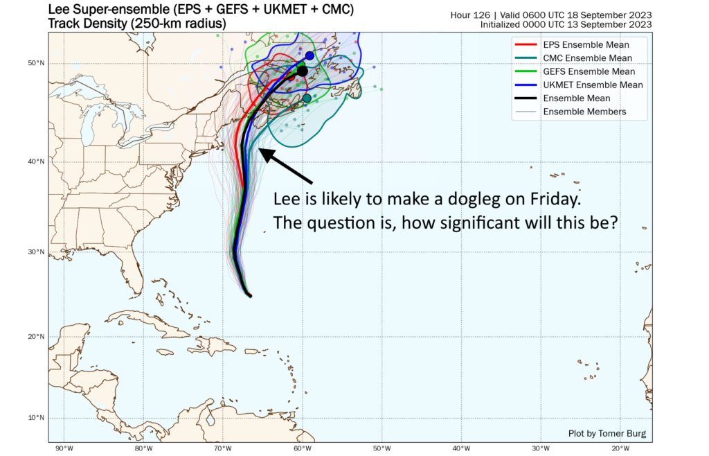
Lee track forecast
Our confidence in where Lee will go over the next couple of days is high. After turning today it should move more or less north, passing to the west of Bermuda. A tropical storm warning is in effect for the island due to the threat of heavy rainfall and strong waves. However, Bermuda thankfully should be spared the worst effects of Lee along this track.
Super-ensemble forecast for Hurricane Lee, with annotation. (Tomer Burg)
After days of uncertainty, we should finally start to get some clarity today on Lee’s track at the end of this week, and its implications for residents of New England and Atlantic Canada. At this point I’m leaning toward a northward track until Friday, at which point the storm should make a dogleg to the left. Our main forecast question, in regard to track, is how significant will this westward bend be? It depends on the strength of a trough of low pressure over the Pennsylvania and New York region.
Our best hurricane and global models indicate that this turn will bring the center of Lee fairly close to the Cape Cod region of Massachusetts early on Saturday morning, although the storm is still expected to remain largely offshore. The center would then move into coastal Maine by Saturday night or Sunday morning. The center would subsequently move through Atlantic Canada and make its exit to the northeast. Again, we should get a better handle on the details of this dogleg over the next 24 hours, and we’ll have an update for you late this afternoon.
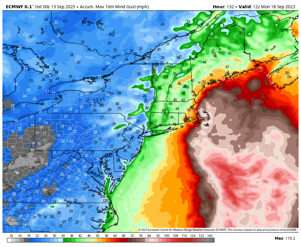
Lee intensity forecast and impacts
Lee now faces a number of factors that should lead to a gradual diminishment in strength, including increasing wind shear and a track that will bring it over cooler seas. However, this process should be slow, and it is likely that Lee will approach Cape Cod and Maine this weekend as a broad, Category 1 hurricane. As it likely will be starting to transition into an extratropical storm, you can probably expect the storm to behave more or less like a very large nor’easter.
Forecast for maximum wind gusts from Hurricane Lee this weekend. (Weather Bell)
After bringing tropical storm impacts to Bermuda, Lee could start to bring Tropical Storm-force winds to the Cape Cod area of Massachusetts by Friday night, and into Maine and Nova Scotia by Saturday morning. How strong will these winds be? That will depend ultimately on the storm’s track and how much its intensity wanes, but the following wind gust forecast from the European model offers a decent representation of risk. Note that wind gusts are short bursts of wind, and that sustained winds will be lower.
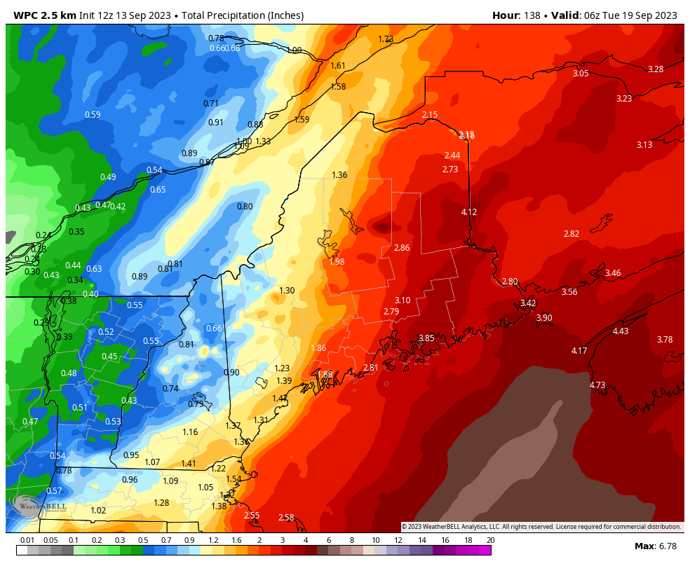
Rainfall totals are likely even less predictable than winds, because they’re not only dependent on track but also more localized conditions that will determine where thunderstorms train. The heaviest totals are likely accumulate in Maine and Nova Scotia, where some areas may see 3 to 6 inches of rainfall in a fairly short period from Lee.
Hurricane Lee rainfall totals. (Weather Bell)
There will, of course, be myriad other effects from this storm. One of them is storm surge. We have seen in the past the larger hurricanes tend to produce a more significant surge of water, and it appears as though Lee could bring a pretty significant coastal surge event into Maine and parts of Canada. The details of this will be worked out in the next day or two as we fine-tune the track forecast. Accordingly, Beach erosion, rough surf, and rip currents are a lock for the East Coast and Atlantic Canada. Not a good beach weekend, to be sure. Areas that see stronger winds and rainfall will likely see downed trees, which could in turn knock down power lines. So be prepared for some disruptions of that kind, as well.
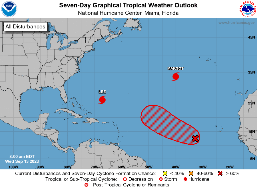
Hurricane Margot and the rest of the gang
Margot is a hurricane at sea. Fortunately there is nothing to see. After spinning and going whee. In a few days, it should cease to be.
Beyond Margot there is another system that is very likely to develop into hurricane over the next several days. This system is probably not a concern for the continental United States or Caribbean islands, but could definitely be something for Bermuda to watch. If so, impacts would occur about a week from now, or maybe a bit longer. But we have a lot of questions to answer before getting into a specific forecast for a storm that would be called Nigel, should it form.
Nigel-to-be will split the uprights between Lee and Margot, most likely. (National Hurricane Center)
Look for our next update on Lee late this afternoon.
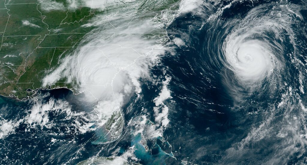
Idalia make landfall near Keaton Beach, Florida, at 7:45 am ET this morning as a Category 3 hurricane with sustained 125-mph winds. The hurricane will continue to produce significant impacts on Florida and other southern states for about the next 24 to 36 hours before it exits into the Atlantic Ocean.
A satellite image of Idalia shortly before Noon ET on Wednesday. That’s Hurricane Franklin spinning in the Atlantic, away from land. (NOAA)
Storm surge
Let’s start with storm surge, which has been considerable in Florida’s Big Bend area. This part of the state has a relatively low population, but Idalia has still been flooding villages and knocking down trees in northern Florida. Peak storm surge levels were about 10 feet, or higher, in the Keaton Beach areas and further south down the coast, toward Yankeetown. As expected, Idalia came in far enough north of the Tampa region on Florida’s Gulf coast to spare that large metro area from its worst effects.
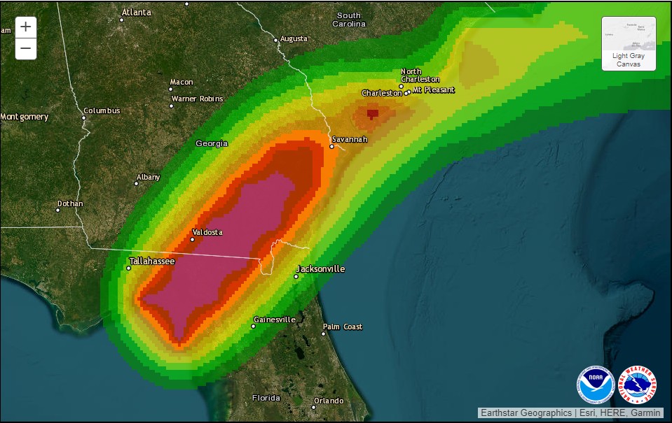
The other area of concern, in terms of surge, is along the coast of South Carolina, particularly near Charleston. Moderate to major flooding is expected in coastal South Carolina later this afternoon when Idalia’s storm surge combines with high tide.
Damaging winds
Idalia briefly reached Category 4 status this morning, but started weakening just before landfall early on Wednesday. This weakening was due to the storm undergoing an eyewall replacement cycle, a process by which an older eyewall weakens and a new one forms. After coming ashore, as storms typically do, this interaction with land has rapidly reduced Idalia’s maximum sustained winds. As of 11 am ET, the National Hurricane Center says they have fallen to 90 mph.
Areas in darker shades of red are most at risk for sustained winds of 60 mph or higher. (National Hurricane Center)
This is still strong enough to uproot trees and down power lines, however. This will be a significant problem in northern Florida, and southern Georgia and South Carolina. Idalia is expected to weaken to just below hurricane strength before moving into the Atlantic Ocean on Thursday morning.
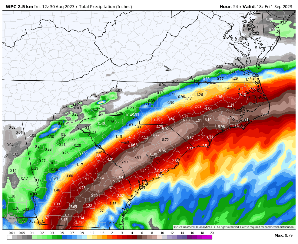
Inland rainfall
Despite Idalia’s relatively rapid forward movement, it is still expected to produce a significant amount of rainfall along its track across the Southeastern United States, including North and South Carolina. Some areas may see as much as 6 to 10 inches of rainfall in total, and a major concern is rainfall rates.
Tropical storms can produce some of the most explosive rainfall rates, which quickly back up drainage systems. Already, this morning, there have been reports of 5 inch-per-hour rainfall rates in Southern Georgia, which will cause significant inland flooding.
NOAA rainfall accumulation forecast for Idalia. (Weather Bell)
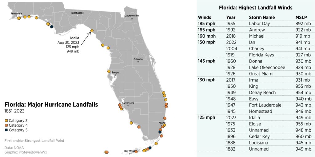
A rare location for such a storm
Meteorologist Steve Bowen has plotted the 21 known hurricanes, since 1851, to strike the Florida peninsula. Many of these storms were clustered in Southern Florida, with only a small handful in the Big Bend region of Florida. The strongest of these, Hurricane Michael, made landfall in 2018 with 160 mph winds.
Florida’s major hurricane landfalls. (Steve Bowen)
Our next update will be today by around 5 pm Eastern.