Quiet tropics are expected to continue into the end of July.
Some signs of a potential tropical wave to monitor in the western Atlantic in early August.
More activity is expected to pick up in mid to late August.
Calm continues a little longer
The tropics continue to look pretty quiet over the next week or so, with no areas worth watching at this time.
Calendar flips into more action?
As we head into August, as we’ve been warning, it does look like the dam will begin to break, slowly at first but with perhaps more voracity as August progresses.
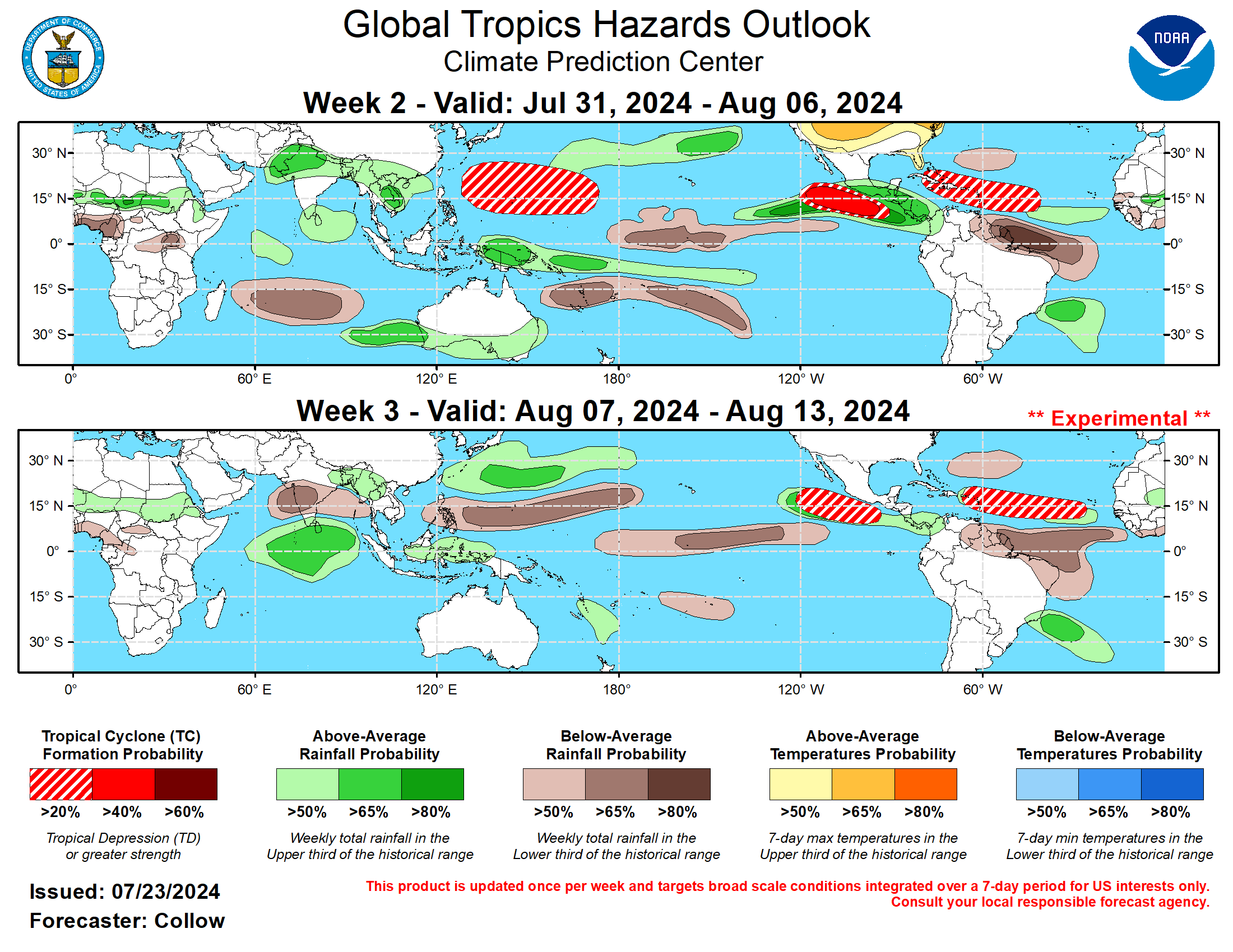
Yesterday afternoon’s week 2 and 3 outlook from the Climate Prediction Center do highlight the Atlantic for tropical potential north of 20 percent.
The week 2-3 tropical hazards outlook from the Climate Prediction Center highlight the western Atlantic and Caribbean through mid-August for possible development. (NOAA CPC)
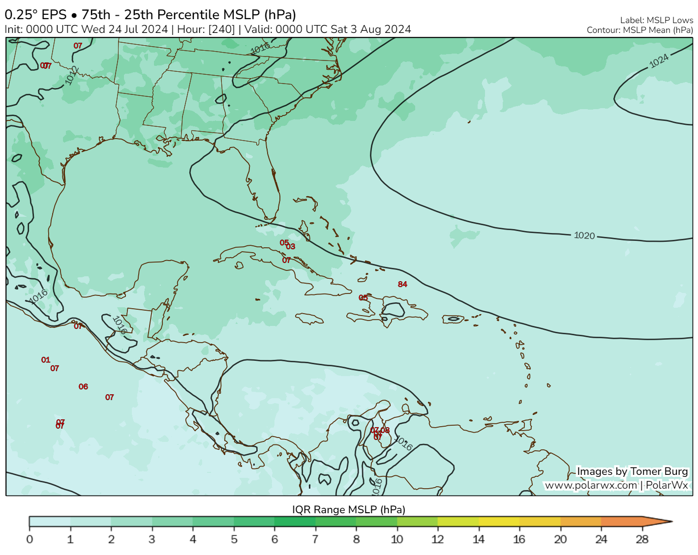
This makes sense on a couple levels. As we noted the other day, it does look like a more favorable “background state” is on the way to the Atlantic basin. Additionally, there is some “buzz” in the modeling looking toward the Bahamas late next week or weekend. The Euro has been on this one for a bit, with the operational model guidance periodically showing something, including at midday today. The ensemble guidance is much less enthusiastic about this, as you can see from the 00z European EPS looking at the IQR difference map from Tomer Burg’s excellent site.
The Euro ensemble IQR difference, which indicates ensemble spread is pretty calm for later next week, with only about 5 or 6 of the 51 ensemble members even showing low pressure. (Tomer Burg)
This really lacks much support from elsewhere at this time. The GFS and its ensemble generally shows little in this region. Even the ICON (for now), which tends to overforecast in the tropics but nailed Beryl in the Gulf doesn’t have a particularly strong signal. That said, wind shear looks relatively modest next week. However, dry air may be in plentiful supply around the area with significant dust in the basin right now, which would limit development. I would say that I can understand modeling picking up on this area for possible development, but I do not necessarily think this merits significant concern at the moment. We’ve got some time, so let’s continue to watch for an uptick in showers and storms in the Bahamas late next week or weekend.
Elsewhere, we continue to see hints of more aggressive change later in August, with European weekly data now showing above normal tropical activity by late month. Not much else we can say at this point, except to make sure you’ve got your season preps complete or soon to be completed as we white knuckle our way into later August.
Signs of change continue to persist in early August.
Mid-August could be quite busy.
Happening in the Atlantic
It’s quiet out there again today.
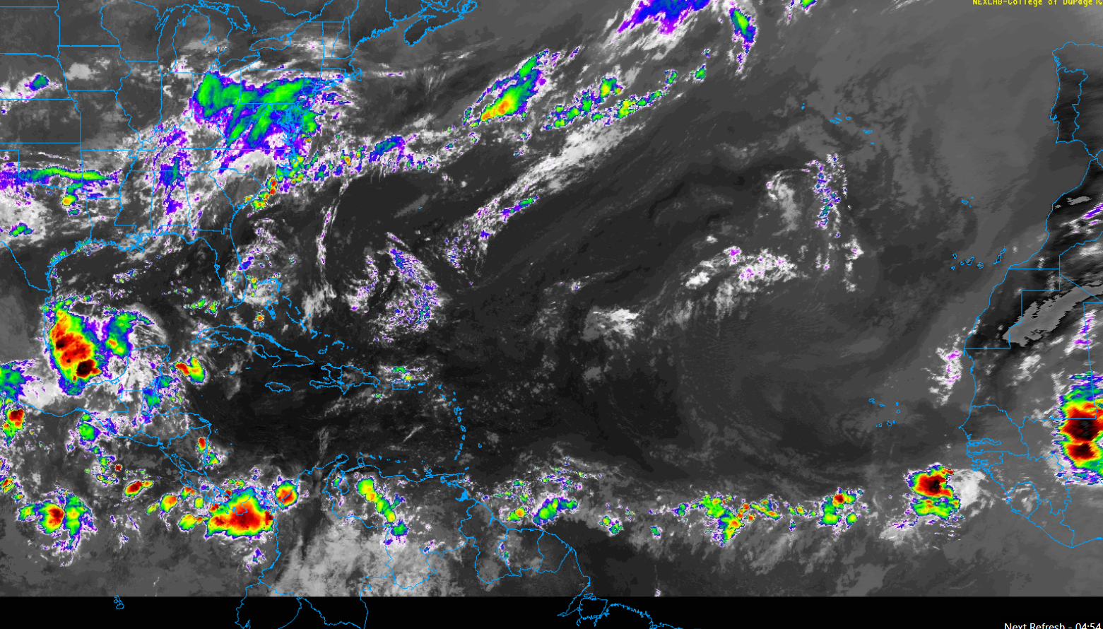
There is nothing of consequence in the Atlantic at this time. (College of DuPage)
There is a smattering of showers across the Atlantic but no organized waves. The Caribbean is quiet. The Gulf is mostly quiet. There is an area of thunderstorms in the Bay of Campeche. Nothing is expected to come of that area, but with thunderstorms pestering the Gulf Coast all week and this down there, you just don’t like to totally take your eyes off this area during hurricane season. Just in case.
But in general, the next 5 to 7 days look to be void of any organized tropical activity in the Atlantic, Caribbean, or Gulf.
When will this change?
The short answer: Probably after the first few days in August.
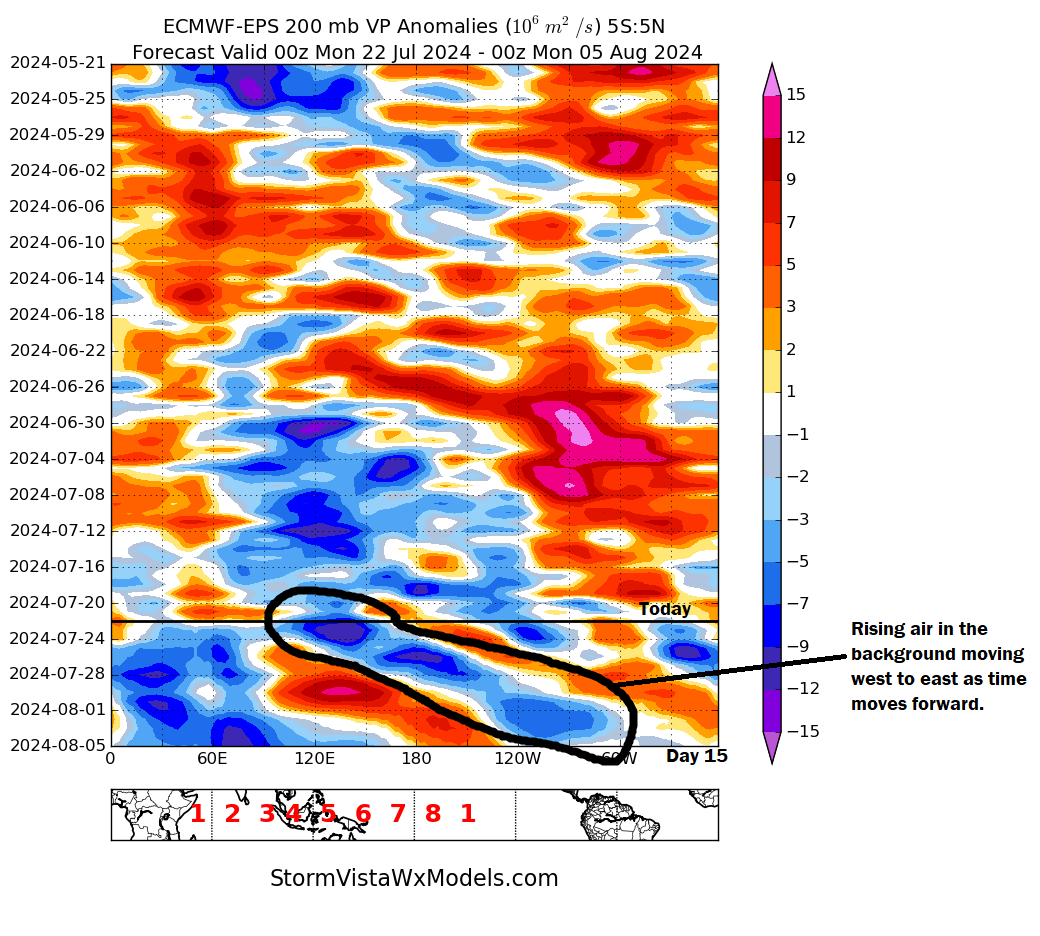
The longer answer: Let’s dive into the weeds a bit. If we look at the background state of the atmosphere in the Atlantic, it’s dominated by sinking air, which is indicated on the chart below by orange and red coloring. However, as we go into early August, I’ve circled an area of migrating rising air. You can match it to the global map below. Notice how over the next two weeks, that area of rising air in the background maneuvers its way from Indonesia to about Central America.
A plot known as a “Hovmoller” showing the Atlantic currently run by sinking air (red/orange color), but with rising air approaching by early August (blue color). (StormVista)
As this rising air moves in, it will gradually tinge the background state of the Atlantic to be more hospitable to tropical systems. Sinking air tends to suppress storm development, whereas rising air promotes it, and as this rising air passes, it will help seed the Atlantic to get ready for action as August progresses.
Could this change? Of course, but in general, this makes sense meteorologically, and this gives us some confidence that it will get busy. And given the current absurdly warm water temperatures across the entire basin, it could get quite busy.
For now, enjoy another week of general calm, and once we see signs of something we’ll address it. Look for our next update on Wednesday or Thursday.
Hurricane Beryl was “only a category one” storm, so how did it cause so many issues?
Today’s post tries to bust the myth of “it was only a category one.”
Hurricane Katrina’s first rodeo
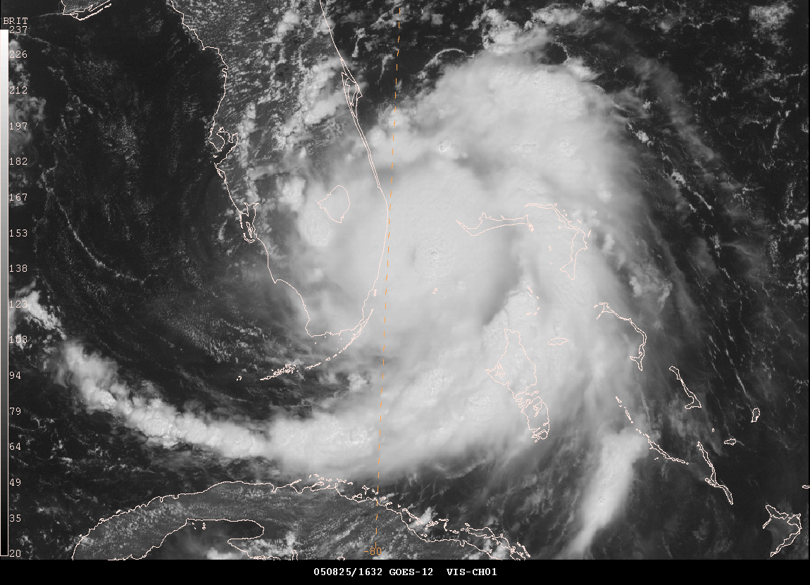
Back in August of 2005, South Florida was struck by a hurricane with maximum sustained winds of 80 mph. The storm made landfall near the border of Miami-Dade and Broward Counties. It killed 14 and caused the 2024 equivalent of $1 billion in damage. It was Hurricane Katrina, and while the storm is obviously remembered for the horror it inflicted on the Gulf Coast, Katrina’s first act was to catch South Florida a bit off-guard. Katrina dumped 10 to 20 inches of rain and knocked out power to about 1.5 million Floridians.
August 26, 2005 front page of The Miami Herald, after Katrina dealt a category 1 blow to South Florida. (Miami Herald)
Katrina intensified from about a 50 mph tropical storm to an 80 mph hurricane in the 24 hours leading up to landfall in South Florida. By the time it re-emerged into the Gulf of Mexico, it had only lost a bit of intensity. You can view a great radar loop from Brian McNoldy’s archive here, and you can see how the storm really got its act together right at landfall.
Katrina approaching the coast of South Florida in 2005 as a category 1 hurricane. (NOAA)
There have been numerous category one hurricanes that have hit land over the years. Yes, most are generally well-behaved. Most cause some damage but not exceptionally long-term disruption. Katrina bucked this trend somewhat, and early this month, Beryl did the same for Houston.
During Katrina, winds gusted to 97 mph in Homestead, 94 mph in Virginia Key, 82 mph in Fort Lauderdale, and 78 mph in Miami. During Beryl, winds gusted to 97 mph just near Freeport, 85 mph in Angleton, 78 mph in Galveston, 84 mph at Hobby Airport, 83 mph at Bush Airport, and 89 mph at the University of Houston. In some ways, Katrina and Beryl make for a nice case study of like-minded category ones. And they also blow away the myth of “it’s only a category one.”
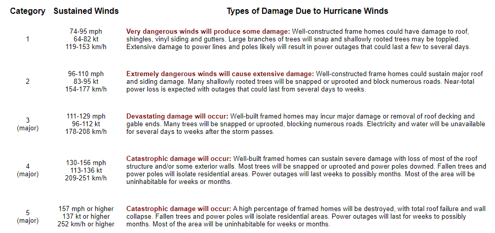
The usefulness of the Saffir-Simpson Scale
For hurricanes, we’ve long relied on the Saffir-Simpson scale to guide us in terms of the definitive categorization of intensity.
The Saffir-Simpson Scale (NOAA)
It’s a great tool for bucketing hurricanes in terms of their strength. Category 5 storms like first ballot hall of famers Andrew, Camille, and Michael generally fit the idea of the scale nicely. It tends to work even better when you consider “major” hurricanes, those that are category 3 and higher. The vast majority of memorable, devastating storms will fall into those buckets.
The uselessness of the Saffir-Simpson Scale
While the scale has true scientific value, many disparate voices within the meteorology and social science communities and beyond have long argued that the Saffir-Simpson Scale falls short in conveying the true threat to the public from a given hurricane. Think about Hurricane Harvey. It was a category 4 hurricane with massive damage on the Middle Texas Coast. By the time it arrived in Houston, it was a tropical storm, but it produced arguably the worst flooding event in Texas history. Hurricane Agnes in 1972 was only a category 1 storm but ended up being the costliest hurricane in American history at the time. The Saffir-Simpson scale, for all its usefulness is based on one variable and one variable only: Maximum sustained wind. If you have a 25 mile radius of hurricane winds that hit 155 mph winds, you have a category 4 hurricane. Whereas a storm like Hurricane Sandy before it was classified as extratropical was “only” a category 1 storm with 85 to 90 mph winds but had a wind field that sent hurricane winds out 175 miles from the center. Which storm is capable of more damage? Or are they capable of equal damage?
Thankfully, most meteorologists recognize this and tend to focus on the impacts more than the category of the storm.
Beryl came in like a wrecking ball
This brings us to Beryl. Right off the top here, let me explain some Matt philosophy for you. Prior to Beryl, Matt believed that things would generally be fine in Houston during category 1 or 2 hurricanes because once they arrived in the city, we’d have gusty winds, some power outages, and scattered damage. But overall, we’d get back up on our feet rather quickly. I even basically said as much literally a few hours before Beryl’s eyewall moved into Houston.
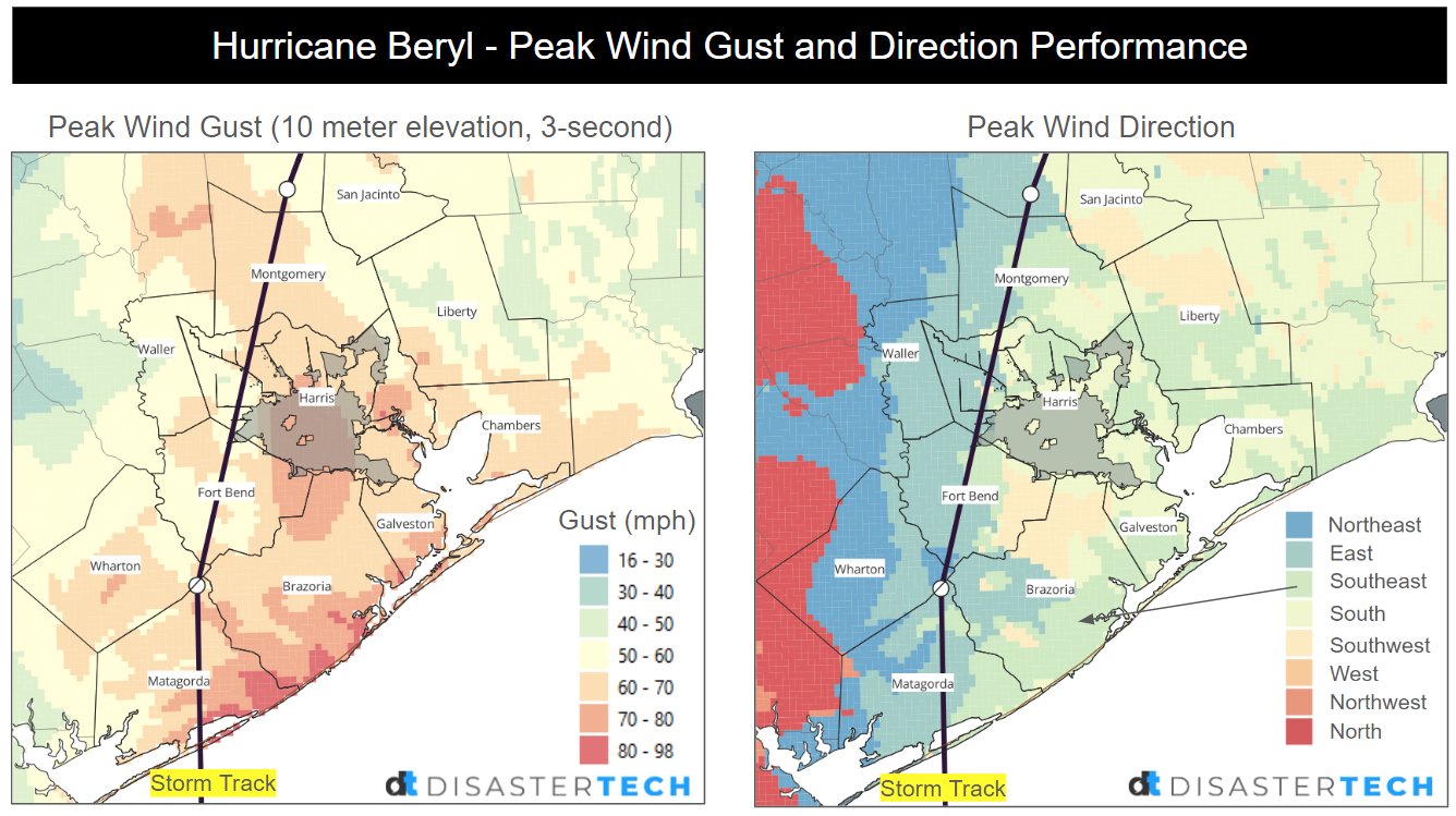
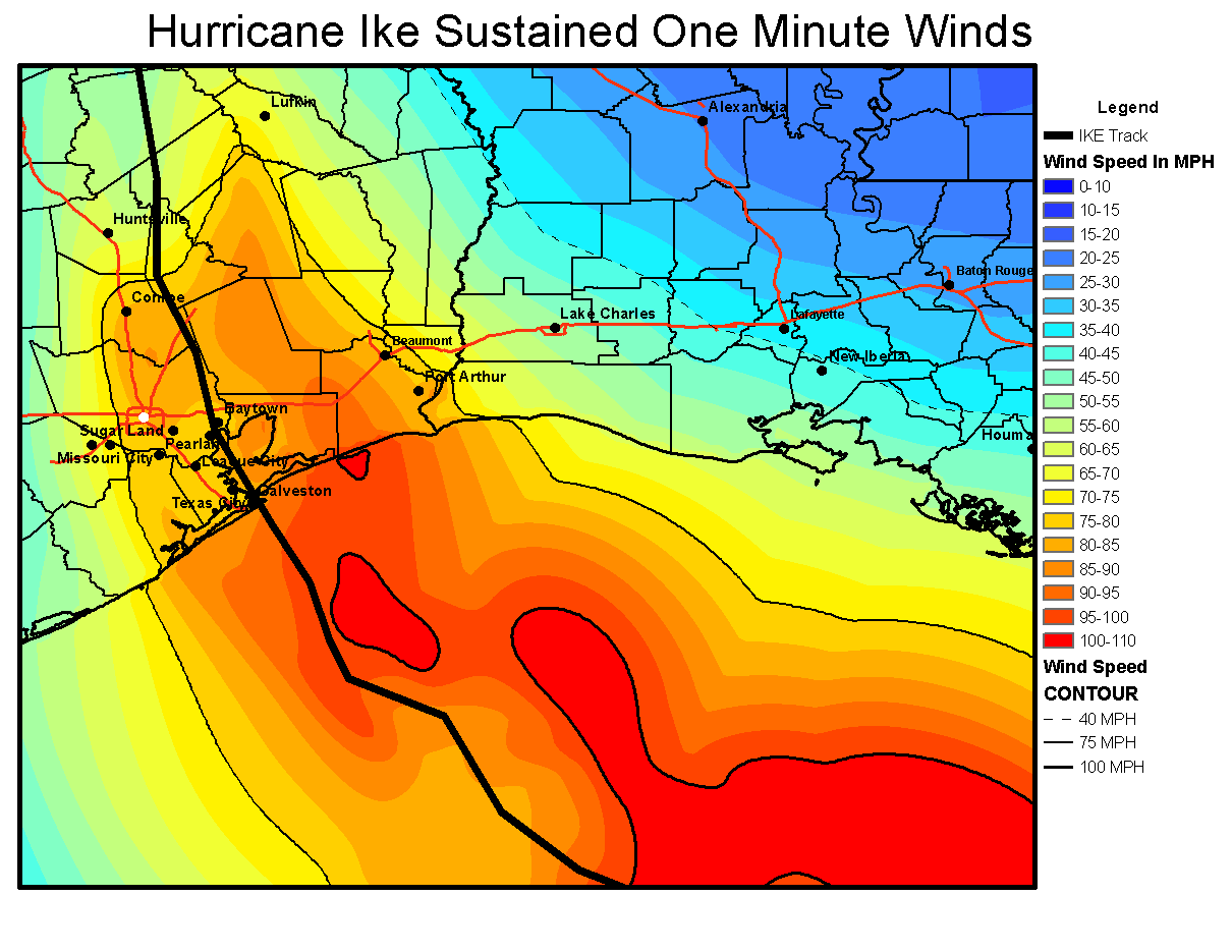
Yes, we did see the forecast 40 to 80 mph wind gusts, but it was more like 60 to 90 mph over the entire metro area. I believed we’d fare well, given that Hurricane Ike, a much larger and somewhat stronger storm in 2008 knocked out power to 2 million customers for up to 2 weeks, even though most of the Houston metro experienced the western (weaker) side. I figured, Beryl, smaller, weaker, but the dirty side…we’ll have outages and some damage, but we’ll manage.
Sustained winds were higher during Ike, but wind gusts in Beryl came up to basically match some of those sustained winds.
Hurricane Ike sustained winds in 2008 ranged from 60 to 90 mph, much higher than in Beryl though wind gusts did get to those levels as well. (NOAA)
Here we are comparing a category 1 relatively compact hurricane to a category 2 unwieldy, large hurricane.
Why did Beryl match Ike’s scope of power outages despite being a weaker storm? First, the track put Houston on the stronger side, so most of the metro area saw the eyewall of Beryl and the strongest winds. Second, and this is where our expectations probably failed us most: Ike was weakening on approach to Texas. Beryl was entering rapid intensification. Beryl was only slightly weaker when it arrived in Houston as it was on the coast. Ike was about 110 mph at landfall and 95 mph once in Houston. Beryl was 80 mph at landfall and 75 mph once in Houston.
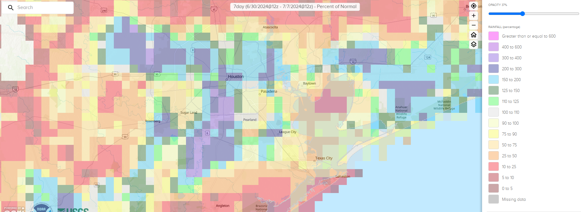
It barely weakened. Why? I think there are two reasons. First, Beryl while undergoing rapid intensification up to landfall took some time to unwind. There is absolutely a difference between a hurricane ramping up at landfall and one that is already decelerating. My new philosophy on this will be to add a category of wind impacts to a storm that is intensifying up to landfall. Second, Beryl was traveling over an area that had seen about 200 to 400 percent of normal rainfall over the prior week.
Percent of normal rainfall between June 30th and July 7th, right before Beryl arrived. (NOAA)
For Houston and points south, basically right on Beryl’s track, we had very soggy ground. This likely contributed both to Beryl maintaining intensity and the wind damage it caused. Trees fall more easily on saturated ground. Could there be an element of brown ocean effect at play here, where hurricanes can maintain intensity over land? Maybe, but that’s a longer-term research project.
There’s certainly an argument to be made about whether or not the power infrastructure in the Houston area is underprepared for the true threat this region faces. After Katrina hit Miami in 2005, 90 percent of customers had power back within three days. Three days after Beryl, about 58 percent of customers were back online in Houston. I don’t want to use this post to assign blame or recommend what should be done, but given that a category one or stronger storm can hit Texas every other year or so on average, this is probably an area that should be a wake up call. Texas should be attempting to match Florida, which has done great work in the hurricane resiliency space, between power restoration and building codes, despite some occasional hurdles.
Most importantly, I want this post to convey that there is honestly no such thing as “only a category one” hurricane or “only a tropical storm.” While classifying storms is good from a scientific standpoint after the fact, it’s not always great science communication in real-time. This was certainly a wake up call for me, and I hope it will be for others that the only thing that matters in each unique storm is what the impacts will be. And hopefully we can convey them in an understandable way to folks here in Texas and elsewhere as our site grows across the Gulf and Atlantic.
The Atlantic is expected to remain generally quiet through the end of the month before activity likely picks back up in early to mid-August.
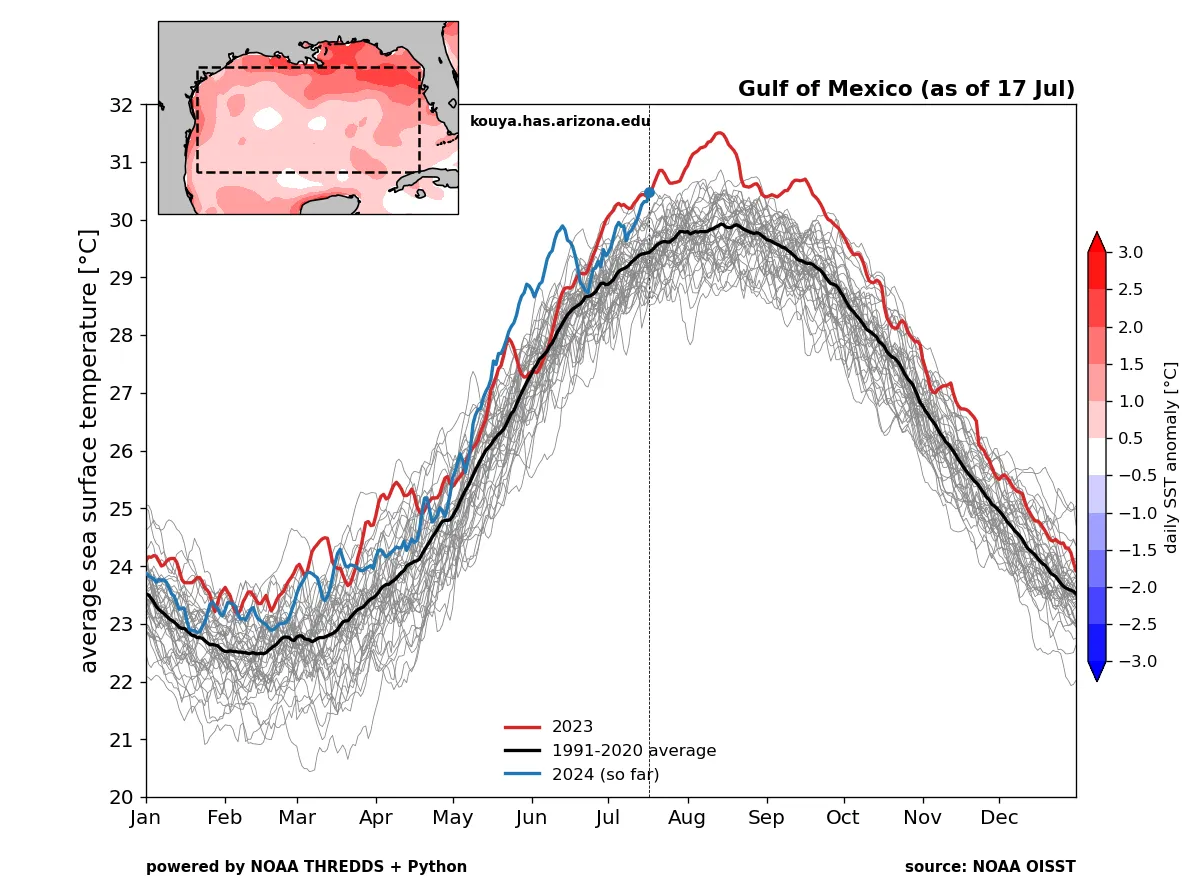
Sea-surface temperatures in the basin have resumed warming after a bit of a pause.
La Niña is technically not here yet, but there is no reason to think it won’t play a big role in the remainder of hurricane season.
Seasonal activity is still expected to be quite a bit more active than normal.
Atlantic slumber continues
No tropical development is expected over the next 7 to 10 days as a continued dust-clogged Atlantic and sinking air in the background suppresses activity. There is a wave emerging off Africa today that a handful of ensemble members give a miniscule chance of development to in about 6 or 7 days, but that seems unlikely and not a concern.
Widespread Saharan dust in yellow, orange, red, and pink is dominating the entire eastern half of the Atlantic Ocean. (University of Wisconsin CIMSS)
How long is this sleep going to last? It’s not uncommon at all for late July to be dormant in the Atlantic, so don’t get too excited. We are still only 6.1 percent of the way through hurricane season using accumulated cyclone energy as a measure. It does appear that conditions will become gradually more conducive to activity again after August 5th, and that’s not just me looking at climatology either. The background state looks to be a good bit less hostile in early August, which could translate to some action before mid-month. I would anticipate a very active mid to late August period right now.
But trouble lurks beneath
After Beryl, one of the common questions was “will this lower water temperatures finally?” And the answer was, “Yes, sort of — along its track.” Even that was minimal, and any benefits we’ve enjoyed from Beryl’s cooler wake have since faded into oblivion. If you look at the Gulf of Mexico specifically, water temperatures have resumed warming, particularly in the central third of the Gulf, where they had not been too terribly warm in June and early July.
The Caribbean? Record warm again. The Atlantic Main Development Region? Approaching record warm levels again. Basically, everywhere you look that matters, water is near record warm levels in the Atlantic. So any hope we may have had that things could meaningfully change this summer appears to be fading. Expect near record warm water to be with us over the peak of hurricane season in the Atlantic.
What’s the deal with La Niña?
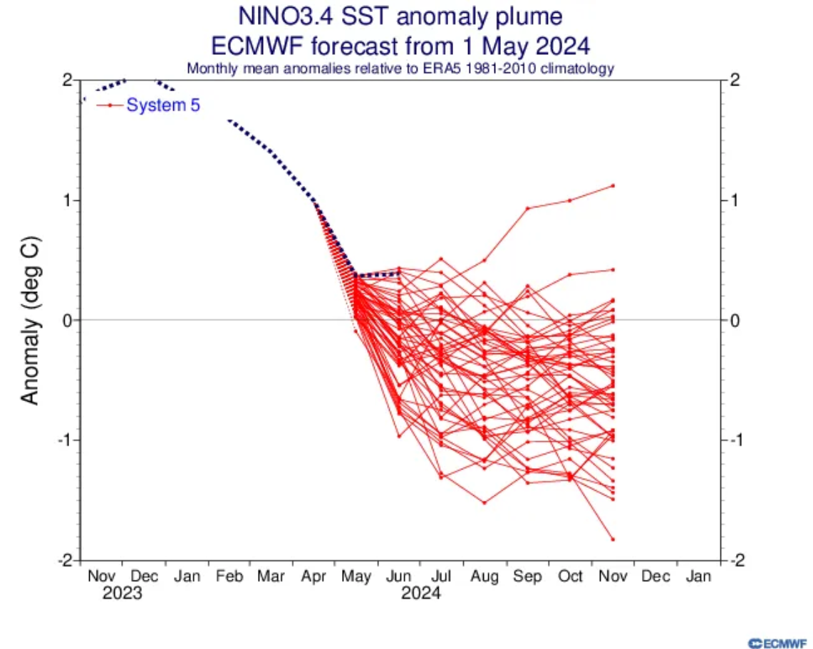
Coming into this hurricane season, one of the big factors for a busy season besides really warm water was La Niña. To this point, however, the La Niña event has mostly been mediocre, at least when you look at the key ENSO 3.4 region water temperatures, which we use to truly define El Niño or La Niña. Here’s the ECMWF forecast for ENSO from May and where we’ve verified.
So far, the sea surface temperature anomalies have tracked with the warmest outliers in the ensemble forecast envelope for La Niña. (ECMWF)
To understand more about what’s happening now, I encourage you to read NOAA’s excellent ENSO blog from last week. In terms of hurricane season, we still expect La Niña to get going next month or in September, but perhaps the pace will be slower than expected earlier in hurricane season. I would argue that most of this “is it or isn’t it La Niña” banter is not particularly important for the rest of hurricane season. The eastern ENSO region is already well into La Niña thresholds, and with a slow drop in SSTs resuming to the west, expect ENSO to behave mostly like La Niña and support an active hurricane season.
The bottom line? All systems seem to be a-go for an active peak of hurricane season.